ATL: HERMINE - Models

Moderator: S2k Moderators

Message
Author
User avatar
centuryv58
Tropical Storm
Tropical Storm
Posts: 233
Age: 67
Joined: Sat Jul 30, 2016 1:24 pm
Location: Southeast Florida

Re: ATL: INVEST 99L - Models

#581 Postby centuryv58 » Sat Aug 20, 2016 12:07 pm

tolakram wrote:
Steve wrote:
tarheelprogrammer wrote:I think when they redo the GFS they need to limit it to 240 hours like the other models. That could stop all the drama and social media posts. Even I get caught up in it sometimes.


I disagree. It's up to people to stop being big babies or on an acute mania/depression wave every time something has potential to develop. Seriously.


Let's ALL just take a breather please. Euro starts in 40 minutes. If you think a single model run is going to make or break a season best stay away. :D


AMEN to that brother! :D
1 likes   

Frank2
Category 5
Category 5
Posts: 4061
Joined: Mon Jul 25, 2005 12:47 pm

Re: ATL: INVEST 99L - Models

#582 Postby Frank2 » Sat Aug 20, 2016 12:10 pm

The old NHC "on the map" thinking made sense - if a trackable system was there, then they'd go to work, but if was just a wave, swirl, etc., then they'd monitor it, but nothing more...

Long-range models that show disaster stress people, only to dissolve into the next run - not worth the anxiety...

GFS is still all over the place as with the others - though AW mentioned in the short term a strong Fall high over NE US in the next 5 days, which could keep 99L westward (the last part is my own thought)...
0 likes   

User avatar
TheAustinMan
Category 5
Category 5
Posts: 1047
Age: 25
Joined: Mon Jul 08, 2013 4:26 pm
Location: United States
Contact:

Re: ATL: INVEST 99L - Models

#583 Postby TheAustinMan » Sat Aug 20, 2016 12:16 pm

This back-and-forth sort of modelling is why global forecast models are tools and not crystal balls or oracles. If we look at the GFS ensembles, we find that there's still plenty of support for tropical cyclogenesis. No tropical wave should simply be "written off" just because some models at this range drop development. The board's having a bit of a meltdown over a run that still has a tropical storm moving through the Florida Straits and into the Gulf - if that were to verify that would still be a fairly significant threat, and I'm sure those who were under the canopy of endless rainfall earlier this week and last week do not want a tropical cyclone headed their way.
3 likes   
ImageImageImage
Treat my opinions with a grain of salt. For official information see your local weather service.

User avatar
gatorcane
S2K Supporter
S2K Supporter
Posts: 23691
Age: 47
Joined: Sun Mar 13, 2005 3:54 pm
Location: Boca Raton, FL

Re: ATL: INVEST 99L - Models

#584 Postby gatorcane » Sat Aug 20, 2016 12:16 pm

12Z NAVGEM more bullish than 06Z which started showing 99L becoming a cyclone the first time in its run guidance:

Image
0 likes   

tolakram
Admin
Admin
Posts: 20009
Age: 62
Joined: Sun Aug 27, 2006 8:23 pm
Location: Florence, KY (name is Mark)

Re: ATL: INVEST 99L - Models

#585 Postby tolakram » Sat Aug 20, 2016 12:22 pm

Just to document the GFS run, it ends up coming ashore just past hour 348. For entertainment only.
Image
0 likes   
M a r k
- - - - -
Join us in chat: Storm2K Chatroom Invite. Android and IOS apps also available.

The posts in this forum are NOT official forecasts and should not be used as such. Posts are NOT endorsed by any professional institution or STORM2K.org. For official information and forecasts, please refer to NHC and NWS products.

tolakram
Admin
Admin
Posts: 20009
Age: 62
Joined: Sun Aug 27, 2006 8:23 pm
Location: Florence, KY (name is Mark)

Re: ATL: INVEST 99L - Models

#586 Postby tolakram » Sat Aug 20, 2016 12:24 pm

HWRF running, still starts slow development before the islands.
0 likes   
M a r k
- - - - -
Join us in chat: Storm2K Chatroom Invite. Android and IOS apps also available.

The posts in this forum are NOT official forecasts and should not be used as such. Posts are NOT endorsed by any professional institution or STORM2K.org. For official information and forecasts, please refer to NHC and NWS products.

User avatar
Steve
S2K Supporter
S2K Supporter
Posts: 9621
Joined: Sat Apr 05, 2003 11:41 pm
Location: Not a state-caster

Re: ATL: INVEST 99L - Models

#587 Postby Steve » Sat Aug 20, 2016 12:24 pm

tarheelprogrammer wrote:
Steve wrote:
tarheelprogrammer wrote:I think when they redo the GFS they need to limit it to 240 hours like the other models. That could stop all the drama and social media posts. Even I get caught up in it sometimes.


I disagree. It's up to people to stop being big babies or on a acute mania/depression wave every time something has potential to develop. Seriously.


To each their own. I just feel like in situations like this the GFS tends to hype up situations or people hype them up when they see it. The ECMWF and CMC tend to not get as much hype but they also only go out to 240 hours. Even as bad as the CMC is it helps not having an extra 144 hours to show pure fantasy. That is all I have to say about it.


I understand your point, but why limit information because some people can't handle it? It's just what I said. People throwing in the towel because a longer range model run changed and no longer threatens them, onus should be on those individuals and not the model = doesn't mean damn the model. Science exists to understand and help explain what's going on. Models are less and less perfect as we go out in time. But we should want to improve them, not do away with them. Information is neutral. People who use it are not. Ultimately, it's on the people squawking, hyping or downing. Anyone with a lick of sense (which should be most on this forum) knows not to hype up models over a week out most of the time. There are rare exceptions of course.
Last edited by Steve on Sat Aug 20, 2016 12:28 pm, edited 2 times in total.
0 likes   

User avatar
Steve
S2K Supporter
S2K Supporter
Posts: 9621
Joined: Sat Apr 05, 2003 11:41 pm
Location: Not a state-caster

Re: ATL: INVEST 99L - Models

#588 Postby Steve » Sat Aug 20, 2016 12:25 pm

Frank2 wrote:The old NHC "on the map" thinking made sense - if a trackable system was there, then they'd go to work, but if was just a wave, swirl, etc., then they'd monitor it, but nothing more...

Long-range models that show disaster stress people, only to dissolve into the next run - not worth the anxiety...

GFS is still all over the place as with the others - though AW mentioned in the short term a strong Fall high over NE US in the next 5 days, which could keep 99L westward (the last part is my own thought)...


Then don't follow them. But wait, you're in here 10 days out. Inconsistent.
0 likes   

User avatar
gatorcane
S2K Supporter
S2K Supporter
Posts: 23691
Age: 47
Joined: Sun Mar 13, 2005 3:54 pm
Location: Boca Raton, FL

Re: ATL: INVEST 99L - Models

#589 Postby gatorcane » Sat Aug 20, 2016 12:31 pm

12Z GFS Ensembles looks to show a lower MSLP in a week's time than the 06Z and focused over the SE Bahamas:

Image
0 likes   

User avatar
NDG
S2K Supporter
S2K Supporter
Posts: 15446
Joined: Sun Jul 09, 2006 10:14 pm
Location: Orlando, FL

Re: ATL: INVEST 99L - Models

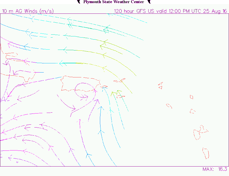
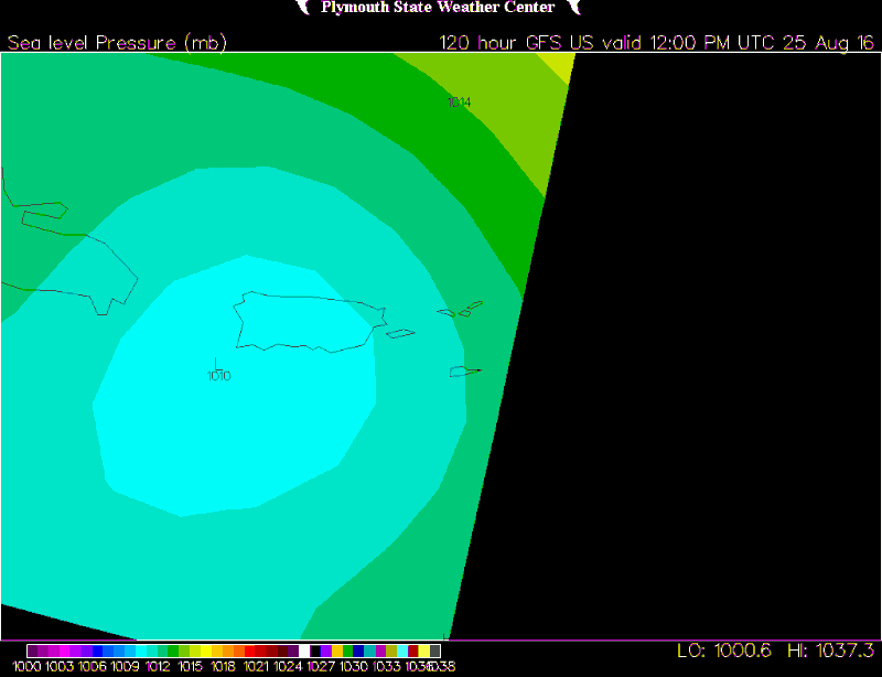
#590 Postby NDG » Sat Aug 20, 2016 12:32 pm

TheStormExpert wrote:Crosses Puerto Rico as an open wave in 120hrs.


Not quiet open.

Image
Image
1 likes   

User avatar
gatorcane
S2K Supporter
S2K Supporter
Posts: 23691
Age: 47
Joined: Sun Mar 13, 2005 3:54 pm
Location: Boca Raton, FL

Re: ATL: INVEST 99L - Models

#591 Postby gatorcane » Sat Aug 20, 2016 12:36 pm

out a little farther at 192 hours, we see a lot of GFS ensembles in the Bahamas area. I count 12 of them below:
Image
1 likes   

User avatar
Blown Away
S2K Supporter
S2K Supporter
Posts: 10146
Joined: Wed May 26, 2004 6:17 am

Re: ATL: INVEST 99L - Models

#592 Postby Blown Away » Sat Aug 20, 2016 12:39 pm

I do think PR/Hispaniola land interaction with a developing weak low played a role in the past 12z, 06z, and 00z GFS runs... The past 18z GFS run lifted farther N once past PR and developed... There are other factors, but the land interaction played a big role IMO...
1 likes   
Hurricane Eye Experience: David 79, Irene 99, Frances 04, Jeanne 04, Wilma 05... EYE COMING MY WAY IN 2024…
Hurricane Brush Experience: Andrew 92, Erin 95, Floyd 99, Matthew 16, Irma 17, Ian 22, Nicole 22…

User avatar
gatorcane
S2K Supporter
S2K Supporter
Posts: 23691
Age: 47
Joined: Sun Mar 13, 2005 3:54 pm
Location: Boca Raton, FL

Re: ATL: INVEST 99L - Models

#593 Postby gatorcane » Sat Aug 20, 2016 12:41 pm

Blown Away wrote:I do think PR/Hispaniola land interaction with a developing weak low played a role in the past 12z, 06z, and 00z GFS runs... The past 18z GFS run lifted farther N once past PR and developed... There are other factors, but the land interaction played a big role IMO...


Yes but the NHC's outlook/shading seems to suggest they think it could maybe go just north of the islands. The NHC also has the FSU Superensembles which we don't have access to. I wonder if the majority of them are showing just north of the islands. NHC has gone to 60% now.
1 likes   

LarryWx
S2K Supporter
S2K Supporter
Posts: 6305
Joined: Sun Sep 07, 2003 2:04 pm
Location: GA

Re: ATL: INVEST 99L - Models

#594 Postby LarryWx » Sat Aug 20, 2016 12:42 pm

gatorcane wrote:out a little farther at 192 hours, we see a lot of GFS ensembles in the Bahamas area. I count 12 of them below:
Image


Gator,
A whopping 8 of the 20 GEFS members hit the S half of FL, which is more than the prior 2 runs at least
1 likes   
Personal Forecast Disclaimer:
The posts in this forum are NOT official forecasts and should not be used as such. They are just the opinion of the poster and may or may not be backed by sound meteorological data. They are NOT endorsed by any professional institution or storm2k.org. For official information, please refer to the NHC and NWS products.

tolakram
Admin
Admin
Posts: 20009
Age: 62
Joined: Sun Aug 27, 2006 8:23 pm
Location: Florence, KY (name is Mark)

Re: ATL: INVEST 99L - Models

#595 Postby tolakram » Sat Aug 20, 2016 12:45 pm

12Z Euro initialized.
Image
0 likes   
M a r k
- - - - -
Join us in chat: Storm2K Chatroom Invite. Android and IOS apps also available.

The posts in this forum are NOT official forecasts and should not be used as such. Posts are NOT endorsed by any professional institution or STORM2K.org. For official information and forecasts, please refer to NHC and NWS products.

User avatar
gatorcane
S2K Supporter
S2K Supporter
Posts: 23691
Age: 47
Joined: Sun Mar 13, 2005 3:54 pm
Location: Boca Raton, FL

Re: ATL: INVEST 99L - Models

#596 Postby gatorcane » Sat Aug 20, 2016 12:46 pm

LarryWx wrote:
gatorcane wrote:out a little farther at 192 hours, we see a lot of GFS ensembles in the Bahamas area. I count 12 of them below:
https://s3.postimg.org/sedapq6fn/gfs_em ... atl_33.png


Gator,
A whopping 8 of the 20 GEFS members hit the S half of FL, which is more than the prior 2 runs at least


Yep interesting indeed seems like more a possibility 99L could make it into at least the SE Bahamas area.
1 likes   

User avatar
Steve
S2K Supporter
S2K Supporter
Posts: 9621
Joined: Sat Apr 05, 2003 11:41 pm
Location: Not a state-caster

Re: ATL: INVEST 99L - Models

#597 Postby Steve » Sat Aug 20, 2016 12:50 pm

gatorcane wrote:
LarryWx wrote:
gatorcane wrote:out a little farther at 192 hours, we see a lot of GFS ensembles in the Bahamas area. I count 12 of them below:
https://s3.postimg.org/sedapq6fn/gfs_em ... atl_33.png


Gator,
A whopping 8 of the 20 GEFS members hit the S half of FL, which is more than the prior 2 runs at least


Yep interesting indeed seems like more a possibility 99L could make it into at least the SE Bahamas area.


Agreed. I think that's one of the hottest spots for this year (along with Florida and possibly the SE US Coast). I think it's also a logical place for 99L to end up (of course it could be a couple hundred miles north or south, but I think it gets that far west at least).
0 likes   

User avatar
Bocadude85
Category 5
Category 5
Posts: 2991
Age: 38
Joined: Mon Apr 18, 2005 2:20 pm
Location: Honolulu,Hi

Re: ATL: INVEST 99L - Models

#598 Postby Bocadude85 » Sat Aug 20, 2016 12:51 pm

HWRF still showing development into a hurricane in the Caribbean...weakens to a tropical storm as it heads towards Hispanola.

http://www.tropicaltidbits.com/analysis/models/?model=hwrf&region=99L&pkg=mslp_wind&runtime=2016082012&fh=108&xpos=0&ypos=445
0 likes   

tolakram
Admin
Admin
Posts: 20009
Age: 62
Joined: Sun Aug 27, 2006 8:23 pm
Location: Florence, KY (name is Mark)

Re: ATL: INVEST 99L - Models

#599 Postby tolakram » Sat Aug 20, 2016 12:56 pm

If you step back through the runs on TT it appears the euro is continuing to increase the vorticity of this system. 4 runs ago there was nothing.

Image
1 likes   
M a r k
- - - - -
Join us in chat: Storm2K Chatroom Invite. Android and IOS apps also available.

The posts in this forum are NOT official forecasts and should not be used as such. Posts are NOT endorsed by any professional institution or STORM2K.org. For official information and forecasts, please refer to NHC and NWS products.

CYCLONE MIKE
Category 5
Category 5
Posts: 2183
Joined: Tue Aug 31, 2004 6:04 pm
Location: Gonzales, LA

Re: ATL: INVEST 99L - Models

#600 Postby CYCLONE MIKE » Sat Aug 20, 2016 12:58 pm

Regarding what this may or not become IF it even makes it into the gulf, when was the last time anything has not struggled to develop in the gulf besides south of 20 in the boc? We have seen it year after year, invest after invest, storm after storm. I hope it gets sheared to death or turns to dust becuase regardless if it's just another wave or invest the last thing we need is another flooding threat down here.
1 likes   
This post is NOT AN OFFICIAL FORECAST and should not be used as such. It is just the opinion of the poster and may or may not be backed by sound meteorological data. It is NOT endorsed by any professional institution including storm2k.org. For Official Information please refer to the NHC and NWS products.


Return to “2016”

Who is online

Users browsing this forum: No registered users and 1 guest