ATL: HERMINE - Models

Moderator: S2k Moderators

Message
Author
User avatar
chaser1
S2K Supporter
S2K Supporter
Posts: 5464
Age: 64
Joined: Sat Oct 15, 2005 5:59 pm
Location: Longwood, Fl

Re: ATL: INVEST 99L - Models

#601 Postby chaser1 » Sat Aug 20, 2016 1:06 pm

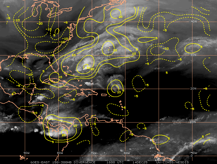
tolakram wrote:If you step back through the runs on TT it appears the euro is continuing to increase the vorticity of this system. 4 runs ago there was nothing.

Image


True, and that especially applies to the system coming off Africa behind as well.
1 likes   
Andy D

(For official information, please refer to the NHC and NWS products.)

Alyono
Professional-Met
Professional-Met
Posts: 6961
Joined: Fri Apr 26, 2013 3:52 pm
Location: Texas Coast

Re: ATL: INVEST 99L - Models

#602 Postby Alyono » Sat Aug 20, 2016 1:10 pm

Blown Away wrote:
Alyono wrote:
SFLcane wrote:Next please... I surrender euro but I get it this basin is just pure garbage as of late.


I take it you did not follow things in the last quit phase. This was NORMAL back then. We are in a quiet phase once again. This may be the norm for 20+ years


I agree, but when does the "Scientific Community" acknowledge we are/have been in a quieter phase... It's been "We are not sure" for years... Yes, following hurricanes when I was a kid during the late 70's and 1980's was painful...


not sure. I'd contend it took about 13 years to say we were in an active phase (and I'd strongly argue, the active phase started in 1985 not 1995)
0 likes   

User avatar
PTrackerLA
Category 5
Category 5
Posts: 5277
Age: 41
Joined: Thu Oct 10, 2002 8:40 pm
Location: Lafayette, LA

Re: ATL: INVEST 99L - Models

#603 Postby PTrackerLA » Sat Aug 20, 2016 1:10 pm

Actually vorticity is even weaker at 72hrs than 00z.
0 likes   

User avatar
Bocadude85
Category 5
Category 5
Posts: 2991
Age: 38
Joined: Mon Apr 18, 2005 2:20 pm
Location: Honolulu,Hi

Re: ATL: INVEST 99L - Models

#604 Postby Bocadude85 » Sat Aug 20, 2016 1:12 pm

PTrackerLA wrote:Actually vorticity is even weaker at 72hrs than 00z.


Yea I'm not sure we will see any development from the Euro this run.
0 likes   

tolakram
Admin
Admin
Posts: 20009
Age: 62
Joined: Sun Aug 27, 2006 8:23 pm
Location: Florence, KY (name is Mark)

Re: ATL: INVEST 99L - Models

#605 Postby tolakram » Sat Aug 20, 2016 1:14 pm

Agreed, washed out at 72 hours while Fiona and the wave behind it are better defined.

Image
0 likes   
M a r k
- - - - -
Join us in chat: Storm2K Chatroom Invite. Android and IOS apps also available.

The posts in this forum are NOT official forecasts and should not be used as such. Posts are NOT endorsed by any professional institution or STORM2K.org. For official information and forecasts, please refer to NHC and NWS products.

User avatar
p1nheadlarry
Category 2
Category 2
Posts: 672
Age: 33
Joined: Wed Jan 29, 2014 2:42 pm
Location: SR County FL

Re: ATL: INVEST 99L - Models

#606 Postby p1nheadlarry » Sat Aug 20, 2016 1:15 pm

SFLcane wrote:Next please... I surrender euro but I get it this basin is just pure garbage as of late.


I'm not willing to write off the next several weeks, nor 99L and possible 90L, but the basin will be on the up near the secondary peak of the season. Especially if the pattern shapes up like it has the last few seasons. Neutral SO conditions persisting until then, or even more negative sst anomalies in the Pacific, could be similar to 1998 or 2010, where we were not in short supply of October hurricanes.
1 likes   
--;->#GoNoles--;->.

User avatar
p1nheadlarry
Category 2
Category 2
Posts: 672
Age: 33
Joined: Wed Jan 29, 2014 2:42 pm
Location: SR County FL

Re: ATL: INVEST 99L - Models

#607 Postby p1nheadlarry » Sat Aug 20, 2016 1:23 pm

Blown Away wrote:NHC has Fiona as remnant low in 48 hours and 12z GFS has at least a Cat 1 hurricane just offshore the SE CONUS... I give up... :double:

IMO, the strengthening Fiona played a big role in squishing 99L in this run...


Fiona will have some trouble with shear over the next 48 hours, but after that it seems like conditions would have Fiona strengthen again before transitioning out of tropical characteristics, but I would reckon closer to where it has already peaked or a tad higher, not a hurricane as the run indicates. At any rate, I trust the NHC forecast, keeping it about the same intensity.

Image

Image
0 likes   
--;->#GoNoles--;->.

tolakram
Admin
Admin
Posts: 20009
Age: 62
Joined: Sun Aug 27, 2006 8:23 pm
Location: Florence, KY (name is Mark)

Re: ATL: INVEST 99L - Models

#608 Postby tolakram » Sat Aug 20, 2016 1:25 pm

Back to no development on the Euro but it's really blowing up what should soon be 90L.
Image
0 likes   
M a r k
- - - - -
Join us in chat: Storm2K Chatroom Invite. Android and IOS apps also available.

The posts in this forum are NOT official forecasts and should not be used as such. Posts are NOT endorsed by any professional institution or STORM2K.org. For official information and forecasts, please refer to NHC and NWS products.

User avatar
p1nheadlarry
Category 2
Category 2
Posts: 672
Age: 33
Joined: Wed Jan 29, 2014 2:42 pm
Location: SR County FL

Re: ATL: INVEST 99L - Models

#609 Postby p1nheadlarry » Sat Aug 20, 2016 1:26 pm

Yellow Evan wrote:idk why people would expect this to bomb out over the Bahamas after interacting with Hispanola and with no MJO/CCKW help. I expect the GFS to back off in intensity gradually the past few days, and now it appears to be playing out.


I wonder if this is why proto-90L gets very intense on this run. The MJO might not be doing 99L any favors, but if the pulse does weaken it could aide the next system if pressures in the western Atl basin drop a little.
0 likes   
--;->#GoNoles--;->.

User avatar
HurricaneBelle
S2K Supporter
S2K Supporter
Posts: 1179
Joined: Sun Aug 27, 2006 6:12 pm
Location: Clearwater, FL

Re: ATL: INVEST 99L - Models

#610 Postby HurricaneBelle » Sat Aug 20, 2016 1:29 pm

tarheelprogrammer wrote:
To each their own. I just feel like in situations like this the GFS tends to hype up situations or people hype them up when they see it. The ECMWF and CMC tend to not get as much hype but they also only go out to 240 hours. Even as bad as the CMC is it helps not having an extra 144 hours to show pure fantasy. That is all I have to say about it.


The GFS doesn't "hype" anything. It's a computer model that generates numerical output. It doesn't care whether it's going to rile up anybody on Storm2K.

The model shouldn't be restricted to 240 hours. Instead, maybe S2K should have a policy restricting opinions on developing systems to one a day, so people can take a breath and look at more than one model run. Then maybe we'd be rid of most of the "OMG Hurricane going to strike in 14 days" and "Season cancel/this basin sucks" posts that have dominated this forum of late.
2 likes   

User avatar
chaser1
S2K Supporter
S2K Supporter
Posts: 5464
Age: 64
Joined: Sat Oct 15, 2005 5:59 pm
Location: Longwood, Fl

Re: ATL: INVEST 99L - Models

#611 Postby chaser1 » Sat Aug 20, 2016 1:29 pm

The EURO update from 24 hours ago is pretty consistant but I do see a couple of subtle distinctions. One is that is appears that the vorticity from 99L might now be just north of the the islands. Two, that whatever vorticity that might be left from Fiona, might well be trapped from moving north. Lastly, the EURO is really cranking this system behind 99L and extremely consistant (and in line with present NHC cone) with 120 hour position of about 22.0N & 45.0W. I'm just curious what weakness is the EURO seeing out in the mid-Atlantic? I just dont seem to see it?
0 likes   
Andy D

(For official information, please refer to the NHC and NWS products.)

User avatar
p1nheadlarry
Category 2
Category 2
Posts: 672
Age: 33
Joined: Wed Jan 29, 2014 2:42 pm
Location: SR County FL

Re: ATL: INVEST 99L - Models

#612 Postby p1nheadlarry » Sat Aug 20, 2016 1:34 pm

Blown Away wrote:I do think PR/Hispaniola land interaction with a developing weak low played a role in the past 12z, 06z, and 00z GFS runs... The past 18z GFS run lifted farther N once past PR and developed... There are other factors, but the land interaction played a big role IMO...


A large system that isn't very organized could have trouble in the islands. Had it obliged to earlier runs and had a robust, structured llc approaching the Antilles, the land interaction/friction might not have as much of an adverse effect. See Georges, Frederic.
0 likes   
--;->#GoNoles--;->.

User avatar
gatorcane
S2K Supporter
S2K Supporter
Posts: 23691
Age: 47
Joined: Sun Mar 13, 2005 3:54 pm
Location: Boca Raton, FL

Re: ATL: INVEST 99L - Models

#613 Postby gatorcane » Sat Aug 20, 2016 1:35 pm

12Z JMA continues to show something entering the SE Bahamas at 168 hours - is usually a conservative model:

Image
1 likes   

User avatar
NDG
S2K Supporter
S2K Supporter
Posts: 15446
Joined: Sun Jul 09, 2006 10:14 pm
Location: Orlando, FL

Re: ATL: INVEST 99L - Models

#614 Postby NDG » Sat Aug 20, 2016 1:36 pm

So I went back on the runs that the GFS shows a strengthening system as it tracks over the Leeward Islands, it was painting a much more moist environment at h70-h40, which might be what the Euro has been handling better all along during the past couple of days or so, so once again the dry environment in the mid levels over the MDR is is putting a lid on development.
1 likes   

Frank2
Category 5
Category 5
Posts: 4061
Joined: Mon Jul 25, 2005 12:47 pm

Re: ATL: INVEST 99L - Models

#615 Postby Frank2 » Sat Aug 20, 2016 1:36 pm

AW (Mark Mancuso) late this morning mentioned a series of Fall-like cold fronts moving off the EC in the next 5 days. Perhaps that will force the subtopical high NE and cause the weakness seen by the model...
0 likes   

User avatar
gatorcane
S2K Supporter
S2K Supporter
Posts: 23691
Age: 47
Joined: Sun Mar 13, 2005 3:54 pm
Location: Boca Raton, FL

Re: ATL: INVEST 99L - Models

#616 Postby gatorcane » Sat Aug 20, 2016 1:38 pm

12Z Euro while weak has a surface low with vorticity in the SE Bahamas at 168 hours:

Image
0 likes   

User avatar
chaser1
S2K Supporter
S2K Supporter
Posts: 5464
Age: 64
Joined: Sat Oct 15, 2005 5:59 pm
Location: Longwood, Fl

Re: ATL: INVEST 99L - Models

#617 Postby chaser1 » Sat Aug 20, 2016 1:44 pm

Well, at least for the present run... the EURO has whatever vorticity associated with 99L squarely located just north of the Southeastern Bahamas. At this juncture of 168 hours from now it looks as if "it" along with "ex-Fiona" and the robust storm/hurricane (wave behind 99L), are all moving in tandum toward the NW to NNW. Short of some massive mid level ridge, it would seem that these features were poised to remain east of the US (unless 99L were to develop at this juncture and threaten the Outer Banks).

I"m still not quite seeing the weakness in the mid-Atlantic causing the developed storm behind 99L to have turned so much more poleward over the previous 72 hr.s
0 likes   
Andy D

(For official information, please refer to the NHC and NWS products.)

User avatar
gatorcane
S2K Supporter
S2K Supporter
Posts: 23691
Age: 47
Joined: Sun Mar 13, 2005 3:54 pm
Location: Boca Raton, FL

Re: ATL: INVEST 99L - Models

#618 Postby gatorcane » Sat Aug 20, 2016 1:44 pm

the 12Z ECMWF develops a cutoff low near Bermuda again and it might create just enough of a weakness to lift the weak surface low north out of the Bahamas. The GFS nor CMC show this cutoff low. Besides that, the ridge over the Carolinas looks strong. The window is tight and timing would be crucial, if 99l does develop and is positioned a little further west it could get under that Carolina high and move west.

Image
0 likes   

User avatar
chaser1
S2K Supporter
S2K Supporter
Posts: 5464
Age: 64
Joined: Sat Oct 15, 2005 5:59 pm
Location: Longwood, Fl

Re: ATL: INVEST 99L - Models

#619 Postby chaser1 » Sat Aug 20, 2016 1:49 pm

Frank2 wrote:AW (Mark Mancuso) late this morning mentioned a series of Fall-like cold fronts moving off the EC in the next 5 days. Perhaps that will force the subtopical high NE and cause the weakness seen by the model...


Ahhh, okay then. At least there would seem to be some cause for any weakness along the Eastern CONUS seaboard. Still, I just don't see anything that causes such a more northward gain in latitude for a developing storm (not 99L but wave east of it) that in 72 hours is still down around 15N and 35W.
0 likes   
Andy D

(For official information, please refer to the NHC and NWS products.)

User avatar
Ntxw
Storm2k Moderator
Storm2k Moderator
Posts: 22785
Joined: Wed Oct 21, 2009 6:34 pm
Location: DFW, Texas

Re: ATL: INVEST 99L - Models

#620 Postby Ntxw » Sat Aug 20, 2016 1:50 pm

NDG wrote:So I went back on the runs that the GFS shows a strengthening system as it tracks over the Leeward Islands, it was painting a much more moist environment at h70-h40, which might be what the Euro has been handling better all along during the past couple of days or so, so once again the dry environment in the mid levels over the MDR is is putting a lid on development.


SAL inversion. Forget the dust, the inversion of warm air above and cool marine air below. In the Great Plains we call this lid the CAP.
2 likes   
The above post and any post by Ntxw is NOT an official forecast and should not be used as such. It is just the opinion of the poster and may or may not be backed by sound meteorological data. It is NOT endorsed by any professional institution including Storm2k. For official information, please refer to NWS products.

  Help support Storm2K!
Help Support Storm2K


Return to “2016”

Who is online

Users browsing this forum: No registered users and 7 guests