
ATL: HERMINE - Post-Tropical - Discussion
Moderator: S2k Moderators
-
Medtronic15

- Tropical Depression

- Posts: 53
- Age: 45
- Joined: Fri Jul 01, 2016 5:25 am
- Location: Texas,USA
Re: ATL: INVEST 99L - Discussion
Right now, firing UP......
0 likes
The posts in this forum are NOT official forecast and should not be used as such. They are just the opinion of the poster and may or may not be backed by sound meteorological data. They are NOT endorsed by any professional institution or STORM2K. For official information, please refer to products from the NHC and NWS.
-
stormhunter7

- Category 2

- Posts: 763
- Joined: Mon May 26, 2008 3:13 pm
- Location: Panama City Beach, Florida
- Contact:
Re: ATL: INVEST 99L - Discussion
I think 99L passed pretty close to this buoy?
http://www.ndbc.noaa.gov/station_page.php?station=41041
http://www.ndbc.noaa.gov/station_page.php?station=41041
0 likes
The following post is NOT an official forecast and should not be used as such. It is just the opinion of the poster and may or may not be backed by sound meteorological data. It is NOT endorsed by any professional institution including storm2k.org For Official Information please refer to the NHC and NWS products. http://www.nhc.noaa.gov

Re: ATL: INVEST 99L - Discussion
stormhunter7 wrote:I think 99L passed pretty close to this buoy?
http://www.ndbc.noaa.gov/station_page.php?station=41041
Two hours of SSE TO SSW winds don't grow on trees at 14N in the deep tropics. There is something at the surface.
2 likes


-
AutoPenalti
- Category 5

- Posts: 4091
- Age: 29
- Joined: Mon Aug 17, 2015 4:16 pm
- Location: Ft. Lauderdale, Florida
Re: ATL: INVEST 99L - Discussion
SFLcane wrote:Most convection in days...
It looks like the west side is waning a bit. South side is starting to pull moisture in.
0 likes
The posts in this forum are NOT official forecasts and should not be used as such. They are just the opinion of the poster and may or may not be backed by sound meteorological data. They are NOT endorsed by any professional institution or STORM2K. For official information, please refer to products from the NHC and NWS.
Model Runs Cheat Sheet:
GFS (5:30 AM/PM, 11:30 AM/PM)
HWRF, GFDL, UKMET, NAVGEM (6:30-8:00 AM/PM, 12:30-2:00 AM/PM)
ECMWF (1:45 AM/PM)
TCVN is a weighted averaged
-
Hurricaneman

- Category 5
- Posts: 7404
- Age: 45
- Joined: Tue Aug 31, 2004 3:24 pm
- Location: central florida
Re: ATL: INVEST 99L - Discussion
Looks like some banding is getting going on the south side and I see no such waning of convection, in fact it seems to be growing and spreading
The posts in this forum are NOT official forecast and should not be used as such. They are just the opinion of the poster and may or may not be backed by sound meteorological data. They are NOT endorsed by any professional institution or STORM2K. For official information, please refer to products from the National Hurricane Center and National Weather Service
The posts in this forum are NOT official forecast and should not be used as such. They are just the opinion of the poster and may or may not be backed by sound meteorological data. They are NOT endorsed by any professional institution or STORM2K. For official information, please refer to products from the National Hurricane Center and National Weather Service
2 likes
-
AutoPenalti
- Category 5
- Posts: 4091
- Age: 29
- Joined: Mon Aug 17, 2015 4:16 pm
- Location: Ft. Lauderdale, Florida
Re: ATL: INVEST 99L - Discussion
Amazing, you can literally see it wrapping around now.
0 likes
The posts in this forum are NOT official forecasts and should not be used as such. They are just the opinion of the poster and may or may not be backed by sound meteorological data. They are NOT endorsed by any professional institution or STORM2K. For official information, please refer to products from the NHC and NWS.
Model Runs Cheat Sheet:
GFS (5:30 AM/PM, 11:30 AM/PM)
HWRF, GFDL, UKMET, NAVGEM (6:30-8:00 AM/PM, 12:30-2:00 AM/PM)
ECMWF (1:45 AM/PM)
TCVN is a weighted averaged
-
SeGaBob
Re: ATL: INVEST 99L - Discussion
Looks decent now. (Relatively speaking) I bet it will get a bit further along every night before waning some in the day until it develops.
0 likes
-
StrongWind

- Tropical Storm

- Posts: 241
- Joined: Tue Aug 31, 2004 5:02 pm
- Location: Deerfield Beach, FL
Re: ATL: INVEST 99L - Discussion
AtlanticWind wrote:Hurricaneman wrote:This now has some convection around the center, could it be possible this gets going before the lesser antilles?
The posts in this forum are NOT official forecast and should not be used as such. They are just the opinion of the poster and may or may not be backed by sound meteorological data. They are NOT endorsed by any professional institution or STORM2K. For official information, please refer to products from the National Hurricane Center and National Weather Service
I think it is definitely possible as globals do not always pick up on development right away.
If it strengthens earlier than expected (ie Antilles vs Bahamas) would one anticipate a more Northerly curving track?
0 likes
-
beoumont

- Category 1

- Posts: 473
- Joined: Sun Jul 10, 2011 4:13 pm
- Location: East Central Florida
- Contact:
Re: ATL: INVEST 99L - Discussion
System kind of reminds me of several sharp easterly waves years ago that produced wind gusts in the Lesser Antilles above 60 mph as it passed through as a very sharp wave; then developed a couple of days later into substantial hurricanes.
0 likes
List of 79 tropical cyclones intercepted by Richard Horodner:
http://www.canebeard.com/page/page/572246.htm
http://www.canebeard.com/page/page/572246.htm


-
USTropics
- Professional-Met

- Posts: 2739
- Joined: Sun Aug 12, 2007 3:45 am
- Location: Florida State University
Re: ATL: INVEST 99L - Discussion
cycloneye wrote:An off topic question. Is the NRL site working as I have tried to get in but nothing.
It's working for me but loading a bit slow:
http://www.nrlmry.navy.mil/TC.html
0 likes
-
cycloneye

- Admin

- Posts: 149511
- Age: 69
- Joined: Thu Oct 10, 2002 10:54 am
- Location: San Juan, Puerto Rico
Re: ATL: INVEST 99L - Discussion
USTropics wrote:cycloneye wrote:An off topic question. Is the NRL site working as I have tried to get in but nothing.
It's working for me but loading a bit slow:
http://www.nrlmry.navy.mil/TC.html
Yes.Slow to navigate.
0 likes
Visit the Caribbean-Central America Weather Thread where you can find at first post web cams,radars
and observations from Caribbean basin members Click Here
and observations from Caribbean basin members Click Here
-
Blown Away

- S2K Supporter

- Posts: 10253
- Joined: Wed May 26, 2004 6:17 am
Re: ATL: INVEST 99L - Discussion
Nice convection this morning... Maybe NHC raises short term development percentages at 8??
0 likes
Hurricane Eye Experience: David 79, Irene 99, Frances 04, Jeanne 04, Wilma 05… Hurricane Brush Experience: Andrew 92, Erin 95, Floyd 99, Matthew 16, Irma 17, Ian 22, Nicole 22…
-
TheStormExpert

-
Gustywind

- Category 5
- Posts: 12334
- Joined: Mon Sep 03, 2007 7:29 am
- Location: Baie-Mahault, GUADELOUPE
Re: ATL: INVEST 99L - Discussion
Tropical Weather Discussion
NWS National Hurricane Center Miami FL
641 AM EDT MON AUG 22 2016
Tropical wave is in the central Atlantic extending from 08N-19N
with axis near 47W, moving W at 15-20 kt within the last 24
hours. There is a 1010 mb low near 14N47W associated with the
wave. Saharan dry air and dust in the wave environment limit the
convection to scattered showers and tstms from 14N to 18N between
44W and 52W. Dry air near this system is expected to inhibit
significant development during the next few days while the
disturbance moves westward to west-northwestward. Environmental
conditions could become more conducive for development late this
week when the system is expected to move near Hispaniola and the
southeastern and central Bahamas.
0 likes
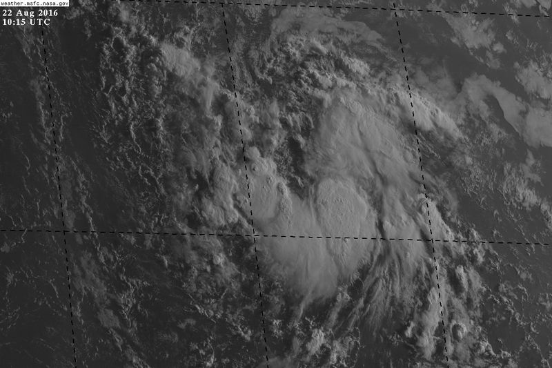
Re: ATL: INVEST 99L - Discussion
This morning 99L still appears to have a broad almost closed off circulation.
http://rammb.cira.colostate.edu/ramsdis ... display=12
http://rammb.cira.colostate.edu/ramsdis ... display=12
0 likes
-
ouragans

- Category 2
- Posts: 501
- Age: 54
- Joined: Sun Jun 12, 2011 12:09 pm
- Location: Abymes, Guadeloupe F.W.I
- Contact:
Re: ATL: INVEST 99L - Discussion
Blown Away wrote:Nice convection this morning... Maybe NHC raises short term development percentages at 8??
I think they will, and same for 5 days. This system has a nice circulation that maintained itself when there was no convection. 99L might even be classified before reaching the islands
0 likes
Personal forecast disclaimer
This post is a personal point of view, not an information. Please refer to official statements for life-threatening decisions.
David '79, Frederic '79, Hugo '89, Iris, Luis & Marilyn '95, Georges '98, Lenny '99, Dean '07, Irma '17, Maria '17, Fiona '22, Philippe '23, Tammy '23
16°13'33.3,"6N -61°36'39.5"W
-
cycloneye
- Admin
- Posts: 149511
- Age: 69
- Joined: Thu Oct 10, 2002 10:54 am
- Location: San Juan, Puerto Rico
Re: ATL: INVEST 99L - Discussion
Shower activity has increased a little over the past 24 hours in
association with a tropical wave located about 850 miles east of
the Lesser Antilles. Dry air near this system is expected to slow
development during the next couple of days days while the
disturbance moves westward to west-northwestward at 15 to 20 mph.
Environmental conditions could become more conducive for development
late this week when the system is expected to move near Hispaniola
and the southeastern and central Bahamas.
* Formation chance through 48 hours...low...20 percent
* Formation chance through 5 days...medium...50 percent
0 likes
Visit the Caribbean-Central America Weather Thread where you can find at first post web cams,radars
and observations from Caribbean basin members Click Here
and observations from Caribbean basin members Click Here
Who is online
Users browsing this forum: No registered users and 100 guests