ATL: HERMINE - Post-Tropical - Discussion
Moderator: S2k Moderators

Re: ATL: INVEST 99L - Discussion
If it can keep developing this convection all day, that will probably help a lot in terms of slowly tightening up a vortex and improving the environment.
0 likes
-
Aric Dunn
- Category 5

- Posts: 21238
- Age: 43
- Joined: Sun Sep 19, 2004 9:58 pm
- Location: Ready for the Chase.
- Contact:
Re: ATL: INVEST 99L - Discussion
on a side note at least starting later tonight and for the 36 hours or so we will have radar 
2 likes
Note: If I make a post that is brief. Please refer back to previous posts for the analysis or reasoning. I do not re-write/qoute what my initial post said each time.
If there is nothing before... then just ask
Space & Atmospheric Physicist, Embry-Riddle Aeronautical University,
I believe the sky is falling...
If there is nothing before... then just ask
Space & Atmospheric Physicist, Embry-Riddle Aeronautical University,
I believe the sky is falling...
-
Nederlander
- S2K Supporter

- Posts: 1259
- Joined: Sat Jul 19, 2008 4:28 pm
- Location: Conroe, TX
Re: ATL: INVEST 99L - Discussion
Ok I see it now... Thanks for the explanation.. Looks like you are right with that call for convection.. Last couple of vis images show a tower bursting right in that area.

Last edited by Nederlander on Tue Aug 23, 2016 9:11 am, edited 1 time in total.
0 likes
-
Hurricaneman

- Category 5
- Posts: 7404
- Age: 45
- Joined: Tue Aug 31, 2004 3:24 pm
- Location: central florida
Re: ATL: INVEST 99L - Discussion
NDG wrote:Aric Dunn wrote:Nederlander wrote:Multiple vorts indeed, but the dominant circulation feature seems to be around 15N, 57W
Thats a mid level vort produced from the overnight convection. use RGB loop and pay attention to the yellow ish color low level clouds they are going right through that feature. the likely candidate would be there area I circled at least for now. likely get more vorts forming and dying.
I agree, that's just a MLC, lower vorticity is further north & west.
Thats usually an indication of NW shear
0 likes
Re: ATL: INVEST 99L - Discussion
SSD initiates Dvorak analysis on this invest.
TXNT25 KNES 231239
TCSNTL
A. TROPICAL DISTURBANCE (99L)
B. 23/1145Z
C. 16.8N
D. 56.5W
E. FIVE/GOES-E
F. T1.0/1.0/D1.0/24HRS
G. IR/EIR/VIS
H. REMARKS...CLOSED LOW LEVEL CIRCULATION COULD NOT BE DISCERNED
IN ANIMATED VISIBLE IMAGERY, SO POSITION IS BASED ON CLOUD SYSTEM
CENTER. SLIGHTLY MORE THAN 2/10 BANDING RESULTS IN A DT OF 1.0. MET AND
PT AGREE. FT IS BASED ON DT.
I. ADDL POSITIONS
NIL
...TURK
0 likes
Personal Forecast Disclaimer:
The posts in this forum are NOT official forecast and should not be used as such. They are just the opinion of the poster and may or may not be backed by sound meteorological data. They are NOT endorsed by any professional institution or storm2k.org. For official information, please refer to RSMC and NWS products.
The posts in this forum are NOT official forecast and should not be used as such. They are just the opinion of the poster and may or may not be backed by sound meteorological data. They are NOT endorsed by any professional institution or storm2k.org. For official information, please refer to RSMC and NWS products.
-
Weatherboy1

- Category 5
- Posts: 1190
- Age: 50
- Joined: Mon Jul 05, 2004 1:50 pm
- Location: Jupiter/Sarasota, FL
Re: ATL: INVEST 99L - Discussion
99 sure looks to be in much better shape now than at any point in her long history. I agree that there does appear to be some separation between a potential LLC and the majority of the convection. But I doubt that will persist much longer at this rate of improvement in organization. We'll see, but it's possible 99 gets its act together much earlier than the central Bahamas. Hmmm...
0 likes
-
cycloneye

- Admin

- Posts: 149520
- Age: 69
- Joined: Thu Oct 10, 2002 10:54 am
- Location: San Juan, Puerto Rico
Re: ATL: INVEST 99L - Recon
000
URNT15 KNHC 231409
AF309 01EEA INVEST HDOB 08 20160823
140000 1705N 06133W 7864 02219 0154 +159 -030 119007 009 008 000 03
140030 1705N 06131W 8187 01876 0158 +173 -037 085005 006 /// /// 03
140100 1705N 06129W 8482 01571 0160 +179 +100 063005 007 /// /// 03
140130 1705N 06127W 8729 01319 0157 +186 +159 041005 005 011 003 03
140200 1704N 06125W 8951 01111 0162 +202 +157 029005 005 011 000 03
140230 1704N 06123W 9205 00867 0163 +215 +162 019007 008 011 000 03
140300 1704N 06121W 9466 00621 0161 +227 +196 012009 009 012 000 00
140330 1703N 06119W 9730 00370 0149 +240 +220 352009 010 012 000 00
140400 1703N 06118W 9783 00316 0139 +245 +224 352009 010 012 001 00
140430 1703N 06116W 9760 00333 0135 +244 +224 353010 010 014 000 00
140500 1703N 06114W 9768 00325 0136 +245 +226 350010 010 014 000 00
140530 1703N 06113W 9778 00314 0134 +245 +227 351010 010 013 000 00
140600 1702N 06111W 9757 00332 0132 +245 +226 350010 011 014 000 00
140630 1702N 06109W 9775 00316 0132 +245 +228 342010 010 012 001 03
140700 1702N 06108W 9768 00319 0130 +245 +228 341010 010 012 000 00
140730 1702N 06106W 9768 00321 0129 +245 +229 339010 010 011 000 03
140800 1701N 06105W 9765 00321 0128 +245 +230 337010 010 013 000 00
140830 1701N 06103W 9770 00314 0127 +245 +230 339010 011 011 001 00
140900 1701N 06101W 9768 00317 0127 +245 +231 338011 011 013 001 00
140930 1701N 06100W 9769 00318 0127 +245 +232 340011 011 012 000 00
$$
0 likes
Visit the Caribbean-Central America Weather Thread where you can find at first post web cams,radars
and observations from Caribbean basin members Click Here
and observations from Caribbean basin members Click Here

Re: ATL: INVEST 99L - Discussion
Hurricaneman wrote:NDG wrote:Aric Dunn wrote:
Thats a mid level vort produced from the overnight convection. use RGB loop and pay attention to the yellow ish color low level clouds they are going right through that feature. the likely candidate would be there area I circled at least for now. likely get more vorts forming and dying.
I agree, that's just a MLC, lower vorticity is further north & west.
Thats usually an indication of NW shear
Yes, since yesterday it has had a bit of a NW shear affecting it, CIMMS has it around 15-20 knots over it, anticylone over it a little displaced to the west of it.
0 likes
-
jlauderdal
- S2K Supporter
- Posts: 7240
- Joined: Wed May 19, 2004 5:46 am
- Location: NE Fort Lauderdale
- Contact:
Re: ATL: INVEST 99L - Discussion
Weatherboy1 wrote:This is going to be very interesting ... and the next couple of model cycles are really going to tell the tale. We're close to the 5-day window where the modelling gets more accurate. So I think we'll have a much better idea about where 99 could be headed in the next 24 hours.
a near perfect track for a big florida hit as it appears it will avoid the Hispaniola-east cuba shredder which has protected us in the past, still need a favorable environment but the track is prime...debby comes to mind about 15 years ago..all models(nogaps was decent back then) had it making a miami strike inside of 72h and it ran into Hispaniola then vaproized within a few hours
2 likes
-
cycloneye
- Admin
- Posts: 149520
- Age: 69
- Joined: Thu Oct 10, 2002 10:54 am
- Location: San Juan, Puerto Rico
Re: ATL: INVEST 99L - Recon

0 likes
Visit the Caribbean-Central America Weather Thread where you can find at first post web cams,radars
and observations from Caribbean basin members Click Here
and observations from Caribbean basin members Click Here
-
tolakram
- Admin
- Posts: 20186
- Age: 62
- Joined: Sun Aug 27, 2006 8:23 pm
- Location: Florence, KY (name is Mark)
Re: ATL: INVEST 99L - Discussion
0 likes
M a r k
- - - - -
Join us in chat: Storm2K Chatroom Invite. Android and IOS apps also available.
The posts in this forum are NOT official forecasts and should not be used as such. Posts are NOT endorsed by any professional institution or STORM2K.org. For official information and forecasts, please refer to NHC and NWS products.
-
cycloneye
- Admin
- Posts: 149520
- Age: 69
- Joined: Thu Oct 10, 2002 10:54 am
- Location: San Juan, Puerto Rico
Re: ATL: INVEST 99L - Recon
URNT15 KNHC 231419
AF309 01EEA INVEST HDOB 09 20160823
141000 1700N 06058W 9770 00316 0126 +245 +232 343011 011 012 000 00
141030 1700N 06056W 9774 00310 0124 +245 +231 341012 012 014 000 03
141100 1700N 06055W 9762 00321 0124 +245 +231 340012 013 014 001 03
141130 1700N 06053W 9765 00317 0123 +241 +238 344012 013 012 000 03
141200 1659N 06051W 9769 00313 0122 +240 +238 343014 015 013 000 00
141230 1659N 06050W 9772 00310 0122 +240 +236 345015 015 013 001 00
141300 1659N 06048W 9768 00312 0121 +242 +232 349015 015 015 001 00
141330 1659N 06046W 9769 00312 0121 +244 +228 353015 015 013 001 00
141400 1658N 06045W 9769 00311 0120 +244 +226 351015 015 014 000 03
141430 1658N 06043W 9770 00310 0120 +245 +221 353015 016 015 000 00
141500 1658N 06041W 9768 00311 0119 +246 +220 353014 015 014 000 00
141530 1658N 06040W 9766 00312 0119 +245 +227 356013 014 014 000 00
141600 1657N 06038W 9778 00301 0119 +245 +227 354013 013 012 001 00
141630 1657N 06036W 9800 00283 0119 +249 +222 353014 014 013 000 03
141700 1657N 06035W 9786 00293 0115 +247 +226 352013 014 013 001 03
141730 1657N 06033W 9761 00313 0115 +241 +237 351013 013 014 000 00
141800 1656N 06031W 9761 00316 0117 +241 +232 347012 013 012 000 00
141830 1656N 06030W 9766 00311 0117 +243 +233 347011 012 012 000 00
141900 1656N 06028W 9769 00308 0118 +243 +233 351011 012 011 001 00
141930 1656N 06026W 9772 00305 0117 +241 +233 356011 012 012 001 00
$$
0 likes
Visit the Caribbean-Central America Weather Thread where you can find at first post web cams,radars
and observations from Caribbean basin members Click Here
and observations from Caribbean basin members Click Here
-
OuterBanker
- S2K Supporter
- Posts: 1761
- Joined: Wed Feb 26, 2003 10:53 am
- Location: Nags Head, NC
- Contact:
-
tolakram
- Admin
- Posts: 20186
- Age: 62
- Joined: Sun Aug 27, 2006 8:23 pm
- Location: Florence, KY (name is Mark)
Re: ATL: INVEST 99L - Discussion
For what it's worth Bastardi has an interesting solution.
Remnants of Fiona cross over Florida into the gulf, need to be watched.
99 moves very close to the coast, making a glancing landfall in southern NC as a cat 3.
Remnants of Fiona cross over Florida into the gulf, need to be watched.
99 moves very close to the coast, making a glancing landfall in southern NC as a cat 3.
0 likes
M a r k
- - - - -
Join us in chat: Storm2K Chatroom Invite. Android and IOS apps also available.
The posts in this forum are NOT official forecasts and should not be used as such. Posts are NOT endorsed by any professional institution or STORM2K.org. For official information and forecasts, please refer to NHC and NWS products.
- - - - -
Join us in chat: Storm2K Chatroom Invite. Android and IOS apps also available.
The posts in this forum are NOT official forecasts and should not be used as such. Posts are NOT endorsed by any professional institution or STORM2K.org. For official information and forecasts, please refer to NHC and NWS products.

Re: ATL: INVEST 99L - Discussion
tolakram wrote:For what it's worth Bastardi has an interesting solution.
Remnants of Fiona cross over Florida into the gulf, need to be watched.
99 moves very close to the coast, making a glancing landfall in southern NC as a cat 3.
This would likely be a very rare double punch on both the east and gulf coast. Interesting for sure.
1 likes
Personal Forecast Disclaimer:
The posts in this forum are NOT official forecast and should not be used as such. They are just the opinion of the poster and may or may not be backed by sound meteorological data. They are NOT endorsed by any professional institution or storm2k.org. For official information, please refer to the NHC and NWS products.
The posts in this forum are NOT official forecast and should not be used as such. They are just the opinion of the poster and may or may not be backed by sound meteorological data. They are NOT endorsed by any professional institution or storm2k.org. For official information, please refer to the NHC and NWS products.
-
cycloneye
- Admin
- Posts: 149520
- Age: 69
- Joined: Thu Oct 10, 2002 10:54 am
- Location: San Juan, Puerto Rico
Re: ATL: INVEST 99L - Recon
Plane decending.
URNT15 KNHC 231429
AF309 01EEA INVEST HDOB 10 20160823
142000 1655N 06024W 9772 00306 0117 +240 +237 355011 011 011 000 00
142030 1655N 06023W 9770 00306 0116 +240 +234 353010 011 011 000 01
142100 1655N 06021W 9768 00307 0115 +240 +234 357008 009 010 001 00
142130 1655N 06020W 9768 00307 0114 +240 +235 001008 009 011 000 00
142200 1654N 06018W 9768 00305 0112 +244 +229 004009 009 010 000 00
142230 1654N 06016W 9770 00304 0111 +250 +214 007009 009 011 000 00
142300 1654N 06015W 9769 00304 0112 +245 +231 008008 009 011 000 03
142330 1654N 06013W 9766 00306 0112 +245 +229 008009 009 010 001 00
142400 1653N 06012W 9768 00306 0113 +245 +229 013009 009 010 001 00
142430 1653N 06010W 9769 00304 0113 +245 +231 016009 010 011 000 03
142500 1653N 06008W 9770 00304 0112 +246 +229 017010 010 010 000 00
142530 1653N 06007W 9769 00304 0111 +246 +224 018009 009 009 001 00
142600 1652N 06005W 9768 00305 0110 +248 +220 029009 009 010 000 00
142630 1652N 06004W 9768 00304 0110 +248 +221 027011 011 010 000 00
142700 1652N 06002W 9768 00304 0111 +245 +225 027011 011 010 000 00
142730 1652N 06000W 9769 00305 0111 +245 +230 027010 011 011 001 00
142800 1651N 05959W 9768 00305 0112 +240 +236 025011 011 010 001 03
142830 1651N 05957W 9770 00304 0113 +242 +236 025010 011 010 000 00
142900 1651N 05955W 9770 00304 0113 +242 +237 023010 010 010 000 00
142930 1651N 05954W 9772 00301 0113 +246 +231 028010 011 010 000 00
$$
0 likes
Visit the Caribbean-Central America Weather Thread where you can find at first post web cams,radars
and observations from Caribbean basin members Click Here
and observations from Caribbean basin members Click Here
-
Aric Dunn
- Category 5
- Posts: 21238
- Age: 43
- Joined: Sun Sep 19, 2004 9:58 pm
- Location: Ready for the Chase.
- Contact:
Re: ATL: INVEST 99L - Discussion
So far wind field from recon as the descended is good indicator something is near by.. how well defined who knows.
0 likes
Note: If I make a post that is brief. Please refer back to previous posts for the analysis or reasoning. I do not re-write/qoute what my initial post said each time.
If there is nothing before... then just ask
Space & Atmospheric Physicist, Embry-Riddle Aeronautical University,
I believe the sky is falling...
If there is nothing before... then just ask
Space & Atmospheric Physicist, Embry-Riddle Aeronautical University,
I believe the sky is falling...
-
cycloneye
- Admin
- Posts: 149520
- Age: 69
- Joined: Thu Oct 10, 2002 10:54 am
- Location: San Juan, Puerto Rico
Re: ATL: INVEST 99L - Recon

0 likes
Visit the Caribbean-Central America Weather Thread where you can find at first post web cams,radars
and observations from Caribbean basin members Click Here
and observations from Caribbean basin members Click Here
-
TheStormExpert
Re: ATL: INVEST 99L - Discussion
tolakram wrote:For what it's worth Bastardi has an interesting solution.
Remnants of Fiona cross over Florida into the gulf, need to be watched.
99 moves very close to the coast, making a glancing landfall in southern NC as a cat 3.
I can see why Joe B. forecasts a North Carolina hit from 99L.
https://twitter.com/MJVentrice/status/768081797733318656
0 likes
Re: ATL: INVEST 99L - Discussion
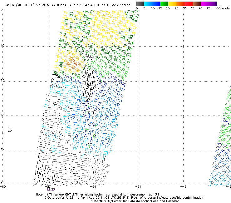
Latest ASCAT did not depict a closed circulation.
0 likes
Personal Forecast Disclaimer:
The posts in this forum are NOT official forecast and should not be used as such. They are just the opinion of the poster and may or may not be backed by sound meteorological data. They are NOT endorsed by any professional institution or storm2k.org. For official information, please refer to RSMC and NWS products.
The posts in this forum are NOT official forecast and should not be used as such. They are just the opinion of the poster and may or may not be backed by sound meteorological data. They are NOT endorsed by any professional institution or storm2k.org. For official information, please refer to RSMC and NWS products.
Who is online
Users browsing this forum: No registered users and 93 guests