ATL: HERMINE - Models
Moderator: S2k Moderators

Re: ATL: INVEST 99L - Models
The HWRF finally gets a better grip on 99L, develops 99L into a tropical storm Saturday night over the NW Bahamas, into a hurricane by Monday afternoon over the SE GOM.
0 likes
-
SouthFLTropics

- Category 5

- Posts: 4258
- Age: 50
- Joined: Thu Aug 14, 2003 8:04 am
- Location: Port St. Lucie, Florida
Re: ATL: INVEST 99L - Models
BobHarlem wrote:Going back to Saturday, Sunday and Monday's 12z euro runs, they are dead on for right now. The actual storm's current position is too far south for Tuesday's run and slightly south of yesterday's euro run. Intensity seems to be right on for all but Tuesday's run.
I'd say the 12z from Monday seems almost spot on right now. If you were to assume the rest of the run is correct it really doesn't start significant development until Saturday night/Sunday morning and leads up to a Monday landfall on the Fl east coast.
0 likes
Fourth Generation Florida Native
Personal Storm History: David 79, Andrew 92, Erin 95, Floyd 99, Irene 99, Frances 04, Jeanne 04, Wilma 05, Matthew 16, Irma 17, Ian 22, Nicole 22, Milton 24
Personal Storm History: David 79, Andrew 92, Erin 95, Floyd 99, Irene 99, Frances 04, Jeanne 04, Wilma 05, Matthew 16, Irma 17, Ian 22, Nicole 22, Milton 24
-
jlauderdal
- S2K Supporter

- Posts: 7240
- Joined: Wed May 19, 2004 5:46 am
- Location: NE Fort Lauderdale
- Contact:
Re: ATL: INVEST 99L - Models
BobHarlem wrote:Going back to Saturday, Sunday and Monday's 12z euro runs, they are dead on for right now. The actual storm's current position is too far south for Tuesday's run and slightly south of yesterday's euro run. Intensity seems to be right on for all but Tuesday's run.
i commented on this over int he discussion thread...the modeling to this point has been good..the anxiety is the inconsistency beyond saturday which really isnt surprising considering it hasnt developed and we know track error rates and intensity forecasting is difficult at best..in summary, starting tomorrow we should have a much better idea of what will happen at 3 days
1 likes


Re: ATL: INVEST 99L - Models
jlauderdal wrote:BobHarlem wrote:Going back to Saturday, Sunday and Monday's 12z euro runs, they are dead on for right now. The actual storm's current position is too far south for Tuesday's run and slightly south of yesterday's euro run. Intensity seems to be right on for all but Tuesday's run.
i commented on this over int he discussion thread...the modeling to this point has been good..the anxiety is the inconsistency beyond saturday which really isnt surprising considering it hasnt developed and we know track error rates and intensity forecasting is difficult at best..in summary, starting tomorrow we should have a much better idea of what will happen at 3 days
Agreed.. Believe the models will become more consistent once we have an established storm.. Or atleast that's the hope!
0 likes
-
CYCLONE MIKE
- Category 5
- Posts: 2183
- Joined: Tue Aug 31, 2004 6:04 pm
- Location: Gonzales, LA
Re: ATL: INVEST 99L - Models
I think that most models have a pretty good handle on what's going to happen. The euro is now a lot more in line with the gfs, track wise at least, and definitely not showing a major hurricane anymore. Gfs just might have been right all along while pretty much everybody was blowing it off, including me at first. Now I'm leaning towards it. Just cant ignore it much longer, way too consistent.
0 likes
This post is NOT AN OFFICIAL FORECAST and should not be used as such. It is just the opinion of the poster and may or may not be backed by sound meteorological data. It is NOT endorsed by any professional institution including storm2k.org. For Official Information please refer to the NHC and NWS products.
Re: ATL: INVEST 99L - Models
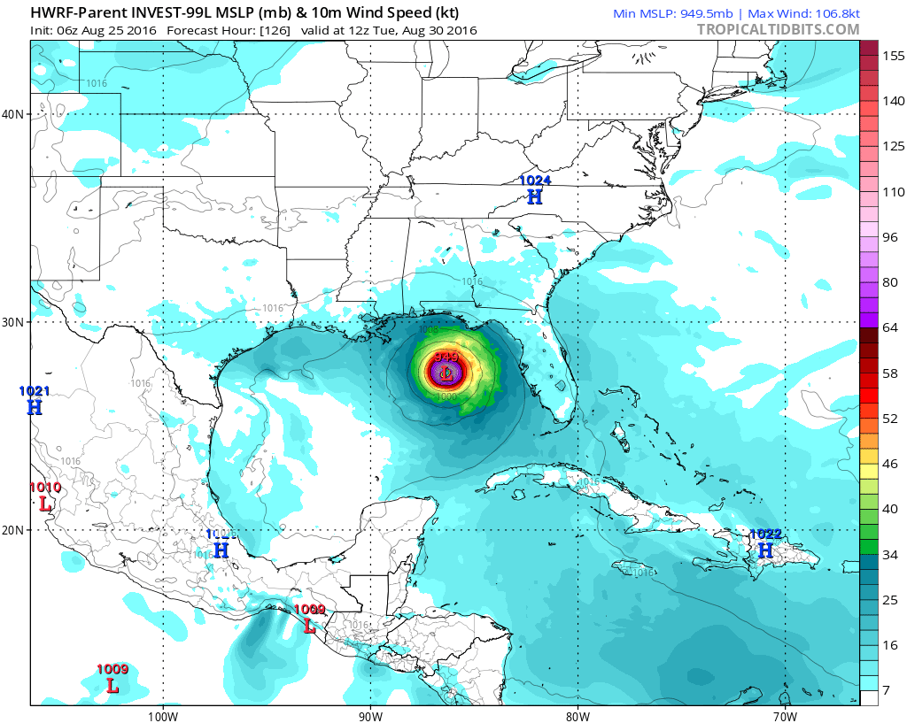
06z HWRF-P ("wide angle"), to give us a sense of location in the Gulf:
1 likes
-
stormlover2013
Re: ATL: INVEST 99L - Models
don't look at just a model one, look at the overall pattern, Bastardi in his video broke it down pretty good...what I do is look at the overall pattern and the pattern the week before, the models are struggling.....especially with intensity so still have a couple days to figure it out
0 likes
-
DESTRUCTION5

- Category 5
- Posts: 4430
- Age: 44
- Joined: Wed Sep 03, 2003 11:25 am
- Location: Stuart, FL
Re: ATL: INVEST 99L - Models
rockyman wrote:06z HWRF-P ("wide angle"), to give us a sense of location in the Gulf:
Grain of salt here... yesterday nothing and a weak storm into spine of state...today cat 3 heading to LA. Tomorrow new solution likley...maybe even 12z.
2 likes
GATOR NATION IS E V E R Y W H E R E !
-
OntarioEggplant
- Category 1

- Posts: 312
- Joined: Sun Aug 07, 2016 11:16 am
Re: ATL: INVEST 99L - Models
CYCLONE MIKE wrote:I think that most models have a pretty good handle on what's going to happen. The euro is now a lot more in line with the gfs, track wise at least, and definitely not showing a major hurricane anymore. Gfs just might have been right all along while pretty much everybody was blowing it off, including me at first. Now I'm leaning towards it. Just cant ignore it much longer, way too consistent.
The only reason the Euro isn't showing a major hurricane anymore is due to land interaction with Florida as it is either too close to it (12Z yesterday) or spends more time over it (00Z). Just a little further offshore, and the Euro is still blowing this up.
1 likes
-
TeamPlayersBlue

- Category 5
- Posts: 3531
- Joined: Tue Feb 02, 2010 1:44 am
- Location: Denver/Applewood, CO
Re: ATL: INVEST 99L - Models
Just need to keep watching the high over the mid-atlantic. Currently it breaks down and the storm is moving north. Just keep watching the center of this high. It seems everytime the center of it gets close to the shore, it dies down quickly and allows the storm to move poleward immediately.
0 likes
Personal Forecast Disclaimer:
The posts in this forum are NOT official forecast and should not be used as such. They are just the opinion of the poster and may or may not be backed by sound meteorological data. They are NOT endorsed by any professional institution or storm2k.org. For official information, please refer to the NHC and NWS products.
The posts in this forum are NOT official forecast and should not be used as such. They are just the opinion of the poster and may or may not be backed by sound meteorological data. They are NOT endorsed by any professional institution or storm2k.org. For official information, please refer to the NHC and NWS products.
-
WeatherEmperor
- S2K Supporter
- Posts: 4806
- Age: 42
- Joined: Thu Sep 04, 2003 2:54 pm
- Location: South Florida
Re: ATL: INVEST 99L - Models
SouthFLTropics wrote:Frank P wrote:SunnyThoughts wrote:06Z HWRF model moving wnw I believe in the Gulf 976mb http://www.tropicaltidbits.com/analysis ... 0&ypos=205
Well that is a shift to the left... wonder if that will be the flavor of the day for the models....
It's actually a shift to the right and more organized from the 00z run. 00z didn't have much of anything.
This has been an issue with the HWRF. It shows development and then drops it, shows development again and drop it yet again for a few days now. I understand the HWRF can be like this but it has done this for almost the entire existence of 99L. Can this particular run really be trusted? What if it magically drops development on its next run cycle?
1 likes
-
Blown Away

- S2K Supporter
- Posts: 10253
- Joined: Wed May 26, 2004 6:17 am
Re: ATL: INVEST 99L - Models
NDG wrote:The HWRF finally gets a better grip on 99L, develops 99L into a tropical storm Saturday night over the NW Bahamas, into a hurricane by Monday afternoon over the SE GOM.
NW Bahamas? Does it go through Fl Straits or across peninsula? Confused how it gets from NW Bahamas to NE Gom... On my phone... Thx
0 likes
Hurricane Eye Experience: David 79, Irene 99, Frances 04, Jeanne 04, Wilma 05… Hurricane Brush Experience: Andrew 92, Erin 95, Floyd 99, Matthew 16, Irma 17, Ian 22, Nicole 22…
-
Frank P
- S2K Supporter
- Posts: 2779
- Joined: Fri Aug 29, 2003 10:52 am
- Location: Biloxi Beach, Ms
- Contact:
Re: ATL: INVEST 99L - Models
WeatherEmperor wrote:SouthFLTropics wrote:Frank P wrote:
Well that is a shift to the left... wonder if that will be the flavor of the day for the models....
It's actually a shift to the right and more organized from the 00z run. 00z didn't have much of anything.
This has been an issue with the HWRF. It shows development and then drops it, shows development again and drop it yet again for a few days now. I understand the HWRF can be like this but it has done this for almost the entire existence of 99L. Can this particular run really be trusted? What if it magically drops development on its next run cycle?
Yesterday's run it was a weak system that ran up the spine of Florida, today it shifts west and becomes what looks to be a major heading for the NGOM... No telling what the next run will bring... eventually one will get it right, lets hope its not this run, esp for the folks in S. LA...
2 likes


Re: ATL: INVEST 99L - Models
You have to give the HWRF some credit for consistency: the past two days worth of runs have insisted that no development would take place until Saturday night / Sunday morning (similar to the Euro). The difference on this run is that it's out over the Gulf and has time to strengthen.
2 likes
-
srainhoutx

- S2K Supporter
- Posts: 6919
- Age: 68
- Joined: Sun Jan 14, 2007 11:34 am
- Location: Haywood County, NC
- Contact:
Re: ATL: INVEST 99L - Models
Blown Away wrote:
NW Bahamas? Does it go through Fl Straits or across peninsula? Confused how it gets from NW Bahamas to NE Gom... On my phone... Thx
Crosses the Keys near Marathon heading WNW into Florida Bay/SE GOM.
1 likes
Carla/Alicia/Jerry(In The Eye)/Michelle/Charley/Ivan/Dennis/Katrina/Rita/Wilma/Ike/Harvey
Member: National Weather Association
Wx Infinity Forums
http://wxinfinity.com/index.php
Facebook.com/WeatherInfinity
Twitter @WeatherInfinity
Member: National Weather Association
Wx Infinity Forums
http://wxinfinity.com/index.php
Facebook.com/WeatherInfinity
Twitter @WeatherInfinity
-
DESTRUCTION5
- Category 5
- Posts: 4430
- Age: 44
- Joined: Wed Sep 03, 2003 11:25 am
- Location: Stuart, FL
Re: ATL: INVEST 99L - Models
Blown Away wrote:NDG wrote:The HWRF finally gets a better grip on 99L, develops 99L into a tropical storm Saturday night over the NW Bahamas, into a hurricane by Monday afternoon over the SE GOM.
NW Bahamas? Does it go through Fl Straits or across peninsula? Confused how it gets from NW Bahamas to NE Gom... On my phone... Thx
Direct shot thru straights and Keys with no land interaction wnw twards LA. Ish...
1 likes
GATOR NATION IS E V E R Y W H E R E !


Re: ATL: INVEST 99L - Models
Blown Away wrote:NDG wrote:The HWRF finally gets a better grip on 99L, develops 99L into a tropical storm Saturday night over the NW Bahamas, into a hurricane by Monday afternoon over the SE GOM.
NW Bahamas? Does it go through Fl Straits or across peninsula? Confused how it gets from NW Bahamas to NE Gom... On my phone... Thx
Hard to tell because it has the the low jumping around over the Bahamas, not really a good grip on it until it gets it through the FL Straights and not through S FL.
1 likes
-
BigB0882
- S2K Supporter
- Posts: 2292
- Joined: Thu Jul 03, 2003 12:08 am
- Location: Baton Rouge, LA
- Contact:
Re: ATL: INVEST 99L - Models
How does the ridge look on the end of the HWRF run? Just curious if it will continue towards LA or will it begin a more northerly track and show the ridge weakening or moving away which may send it toward AL/MS.
1 likes
Re: ATL: INVEST 99L - Models
TheStormExpert wrote:12z Model Guidance.
Not a fan of this westward shift!
1 likes
Who is online
Users browsing this forum: No registered users and 50 guests