2016 EPAC Season

This is the general tropical discussion area. Anyone can take their shot at predicting a storms path.

Moderator: S2k Moderators

Forum rules

The posts in this forum are NOT official forecasts and should not be used as such. They are just the opinion of the poster and may or may not be backed by sound meteorological data. They are NOT endorsed by any professional institution or STORM2K. For official information, please refer to products from the National Hurricane Center and National Weather Service.

Help Support Storm2K
Message
Author
User avatar
cycloneye
Admin
Admin
Posts: 145331
Age: 68
Joined: Thu Oct 10, 2002 10:54 am
Location: San Juan, Puerto Rico

Re: 2016 EPAC Season

#761 Postby cycloneye » Fri Aug 26, 2016 6:56 pm

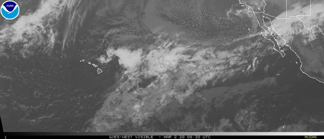
A large area of disturbed weather has formed several hundred miles
south of the southwestern coast of Mexico. Environmental conditions
are expected to be somewhat conducive for gradual development after
the weekend while the system moves west-northwestward at 10 to 15
mph.
* Formation chance through 48 hours...low...near 0 percent
* Formation chance through 5 days...low...30 percent
0 likes   
Visit the Caribbean-Central America Weather Thread where you can find at first post web cams,radars
and observations from Caribbean basin members Click Here

dexterlabio
Category 5
Category 5
Posts: 3468
Joined: Sat Oct 24, 2009 11:50 pm

Re: 2016 EPAC Season

#762 Postby dexterlabio » Fri Aug 26, 2016 9:35 pm

Interesting how most people downplay this year's EPAC season but it continues to give us surprises. :lol:
0 likes   
Personal Forecast Disclaimer:
The posts in this forum are NOT official forecast and should not be used as such. They are just the opinion of the poster and may or may not be backed by sound meteorological data. They are NOT endorsed by any professional institution or storm2k.org. For official information, please refer to the NHC and NWS products.

User avatar
Kingarabian
S2K Supporter
S2K Supporter
Posts: 15981
Joined: Sat Aug 08, 2009 3:06 am
Location: Honolulu, Hawaii

Re: 2016 EPAC Season

#763 Postby Kingarabian » Fri Aug 26, 2016 9:47 pm

dexterlabio wrote:Interesting how most people downplay this year's EPAC season but it continues to give us surprises. :lol:


People simply ignored that there was a +PDO and that it was at record levels.
0 likes   
RIP Kobe Bryant

User avatar
Yellow Evan
Professional-Met
Professional-Met
Posts: 16143
Age: 27
Joined: Fri Jul 15, 2011 12:48 pm
Location: Henderson, Nevada/Honolulu, HI
Contact:

Re: 2016 EPAC Season

#764 Postby Yellow Evan » Fri Aug 26, 2016 9:48 pm

dexterlabio wrote:Interesting how most people downplay this year's EPAC season but it continues to give us surprises. :lol:


I've never personally witnessed a +PDO/non-Nino 80s like setup play out before, plus La Nina never happened.
0 likes   

talkon
Tropical Storm
Tropical Storm
Posts: 204
Joined: Tue Aug 12, 2014 7:28 am

Re: 2016 EPAC Season

#765 Postby talkon » Fri Aug 26, 2016 10:29 pm

12Z EC shows 2 more storms in 10 days, while 18Z GFS shows 3 more in 16 days.
The EPAC is surely going to be hyperactive again.
0 likes   
DISCLAIMER: I am not a meteorologist. Any posts I made, unless copied from some official agency, are only my opinion and is unofficial and often exaggerated. Please refer to your official RSMC for official products and warnings.

User avatar
kala
Tropical Storm
Tropical Storm
Posts: 101
Age: 28
Joined: Wed Jun 08, 2016 5:35 am
Location: Arizona

Re: 2016 EPAC Season

#766 Postby kala » Sun Aug 28, 2016 3:29 am

I'm not saying anything in particular but... :wink:

Image

Image

It's quite amazing how far along we are already in the EPAC proper.

Just one storm behind 1992 as of today, and potentially two more storms in the first few days of September. At least to me, it's looking like a W, X, Y, or even Z storm might be possible this season, especially if EPAC can keep up the storm "density" that it's achieved thus far, into October.
0 likes   

User avatar
cycloneye
Admin
Admin
Posts: 145331
Age: 68
Joined: Thu Oct 10, 2002 10:54 am
Location: San Juan, Puerto Rico

Re: 2016 EPAC Season

#767 Postby cycloneye » Sun Aug 28, 2016 7:12 am

1. A broad area of cloudiness and disorganized showers is located
several hundred miles south of the southern tip of the Baja
California peninsula. Development, if any, of this system is
expected to be slow to occur as it moves westward or west-
northwestward during the next few days.
* Formation chance through 48 hours...low...10 percent
* Formation chance through 5 days...low...20 percent

2. An area of low pressure is expected to form later this week a few
hundred miles south or southeast of Acapulco, Mexico. Environmental
conditions appear conducive for slow development of this system as
it moves generally west-northwestward.
* Formation chance through 48 hours...low...near 0 percent
* Formation chance through 5 days...low...20 percent
0 likes   
Visit the Caribbean-Central America Weather Thread where you can find at first post web cams,radars
and observations from Caribbean basin members Click Here

User avatar
Kingarabian
S2K Supporter
S2K Supporter
Posts: 15981
Joined: Sat Aug 08, 2009 3:06 am
Location: Honolulu, Hawaii

Re: 2016 EPAC Season

#768 Postby Kingarabian » Mon Aug 29, 2016 6:23 am

ZCZC MIATWOEP ALL
TTAA00 KNHC DDHHMM

TROPICAL WEATHER OUTLOOK
NWS NATIONAL HURRICANE CENTER MIAMI FL
1100 PM PDT SUN AUG 28 2016

For the eastern North Pacific...east of 140 degrees west longitude:

The National Hurricane Center is issuing advisories on Hurricane
Lester, located about 1100 miles west-southwest of the southern
tip of the Baja California peninsula.

1. A large area of cloudiness and showers located several hundred
miles south-southwest of the southern tip of the Baja California
peninsula is showing some signs of organization. However, any
development of this system is expected to be slow to occur while it
moves slowly westward or west-northwestward during the next few
days.
* Formation chance through 48 hours...low...10 percent
* Formation chance through 5 days...low...20 percent

2. An area of low pressure is expected to form later this week a few
hundred miles south or southeast of Acapulco, Mexico. Environmental
conditions appear conducive for slow development of this system
while it moves west-northwestward or northwestward.
* Formation chance through 48 hours...low...near 0 percent
* Formation chance through 5 days...medium...40 percent

Forecaster Kimberlain
0 likes   
RIP Kobe Bryant

User avatar
Ntxw
Storm2k Moderator
Storm2k Moderator
Posts: 22785
Joined: Wed Oct 21, 2009 6:34 pm
Location: DFW, Texas

Re: 2016 EPAC Season

#769 Postby Ntxw » Mon Aug 29, 2016 9:17 am

Twins, possibly both majors later today if Madeline succeeds. Brings back the triplets memories. Both of these should rack up some huge ACE.

Image
0 likes   
The above post and any post by Ntxw is NOT an official forecast and should not be used as such. It is just the opinion of the poster and may or may not be backed by sound meteorological data. It is NOT endorsed by any professional institution including Storm2k. For official information, please refer to NWS products.

  Help support Storm2K!
Help Support Storm2K

User avatar
Yellow Evan
Professional-Met
Professional-Met
Posts: 16143
Age: 27
Joined: Fri Jul 15, 2011 12:48 pm
Location: Henderson, Nevada/Honolulu, HI
Contact:

Re: 2016 EPAC Season

#770 Postby Yellow Evan » Mon Aug 29, 2016 9:18 am

000
ABPZ20 KNHC 291151
TWOEP

TROPICAL WEATHER OUTLOOK
NWS NATIONAL HURRICANE CENTER MIAMI FL
500 AM PDT MON AUG 29 2016

For the eastern North Pacific...east of 140 degrees west longitude:

The National Hurricane Center is issuing advisories on Hurricane
Lester, located over a thousand miles west-southwest of the southern
tip of the Baja California peninsula.

A large area of disorganized cloudiness and showers is located
several hundred miles south-southwest of the southern tip of the
Baja California peninsula. Any development of this system is
expected to be slow to occur while it moves slowly westward or
west-northwestward during the next few days.
* Formation chance through 48 hours...low...10 percent
* Formation chance through 5 days...low...30 percent

An area of low pressure is expected to form later this week a few
hundred miles south or southeast of Acapulco, Mexico. Environmental
conditions appear conducive for slow development of this system
while it moves west-northwestward or northwestward.
* Formation chance through 48 hours...low...near 0 percent
* Formation chance through 5 days...medium...40 percent

$$
Forecaster Roberts
0 likes   

User avatar
Extratropical94
Professional-Met
Professional-Met
Posts: 3538
Age: 30
Joined: Wed Oct 20, 2010 6:36 am
Location: Hamburg, Germany
Contact:

Re: 2016 EPAC Season

#771 Postby Extratropical94 » Mon Aug 29, 2016 12:39 pm

000
ABPZ20 KNHC 291732
TWOEP

TROPICAL WEATHER OUTLOOK
NWS NATIONAL HURRICANE CENTER MIAMI FL
1100 AM PDT MON AUG 29 2016

For the eastern North Pacific...east of 140 degrees west longitude:

The National Hurricane Center is issuing advisories on Hurricane
Lester, located well to the west of the southern tip of the Baja
California peninsula.

Disorganized showers and a few thunderstorms continue in association
with a broad area of low pressure located several hundred miles
south-southwest of the southern tip of the Baja California
peninsula. Any development of this system is expected to be slow to
occur while it moves slowly westward or west-northwestward during
the next few days.
* Formation chance through 48 hours...low...10 percent
* Formation chance through 5 days...low...30 percent

An area of low pressure is expected to form toward the end of
the week a few hundred miles south or southeast of Acapulco,
Mexico. Environmental conditions appear conducive for slow
development of this system while it moves west-northwestward or
northwestward.
* Formation chance through 48 hours...low...near 0 percent
* Formation chance through 5 days...medium...40 percent

$$
Forecaster Roberts
0 likes   
54° 11' 59'' N, 9° 9' 20'' E
Boomer Sooner!
Go Broncos! Go Cards! Go Niners!
- Daniel

User avatar
Darvince
Tropical Storm
Tropical Storm
Posts: 184
Joined: Wed Sep 02, 2015 10:25 pm
Location: Phoenix AZ

Re: 2016 EPAC Season

#772 Postby Darvince » Mon Aug 29, 2016 12:52 pm

why hello there
Image
0 likes   
:craz:

User avatar
Ntxw
Storm2k Moderator
Storm2k Moderator
Posts: 22785
Joined: Wed Oct 21, 2009 6:34 pm
Location: DFW, Texas

Re: 2016 EPAC Season

#773 Postby Ntxw » Mon Aug 29, 2016 2:08 pm

Madeline did it, twin majors. 5th major of the season and Lester probably 3rd Cat 4

Image
0 likes   
The above post and any post by Ntxw is NOT an official forecast and should not be used as such. It is just the opinion of the poster and may or may not be backed by sound meteorological data. It is NOT endorsed by any professional institution including Storm2k. For official information, please refer to NWS products.


  Help support Storm2K!

Help Support Storm2K


hurricanes1234
Category 5
Category 5
Posts: 2907
Joined: Sat Jul 28, 2012 6:19 pm
Location: Trinidad and Tobago

Re: 2016 EPAC Season

#774 Postby hurricanes1234 » Mon Aug 29, 2016 6:07 pm

Les Twins :lol: :lol:

Image
1 likes   
PLEASE NOTE: With the exception of information from weather agencies that I may copy and paste here, my posts will NEVER be official, since I am NOT a meteorologist. They are solely my amateur opinion, and may or may not be accurate. Therefore, please DO NOT use them as official details, particularly when making important decisions. Thank you.

User avatar
1900hurricane
Category 5
Category 5
Posts: 6059
Age: 34
Joined: Fri Feb 06, 2015 12:04 pm
Location: Houston, TX
Contact:

Re: 2016 EPAC Season

#775 Postby 1900hurricane » Mon Aug 29, 2016 7:05 pm

Now if only 92C can give us triplets. I'm not holding my breath though. :P
0 likes   
Contract Meteorologist. TAMU & MSST. Fiercely authentic, one of a kind. We are all given free will, so choose a life meant to be lived. We are the Masters of our own Stories.
Opinions expressed are mine alone.

Follow me on Twitter at @1900hurricane : Read blogs at https://1900hurricane.wordpress.com/

User avatar
Kingarabian
S2K Supporter
S2K Supporter
Posts: 15981
Joined: Sat Aug 08, 2009 3:06 am
Location: Honolulu, Hawaii

Re: 2016 EPAC Season

#776 Postby Kingarabian » Mon Aug 29, 2016 7:25 pm

Is the MJO still in the WPAC?
0 likes   
RIP Kobe Bryant

User avatar
1900hurricane
Category 5
Category 5
Posts: 6059
Age: 34
Joined: Fri Feb 06, 2015 12:04 pm
Location: Houston, TX
Contact:

Re: 2016 EPAC Season

#777 Postby 1900hurricane » Mon Aug 29, 2016 9:48 pm

Kingarabian wrote:Is the MJO still in the WPAC?

It looks like it has deamplified to me. The biggest upward 200 mb vertical motion anomalies are actually in the EPac right now with the tropical cyclone activity.

Image

Image
0 likes   
Contract Meteorologist. TAMU & MSST. Fiercely authentic, one of a kind. We are all given free will, so choose a life meant to be lived. We are the Masters of our own Stories.
Opinions expressed are mine alone.

Follow me on Twitter at @1900hurricane : Read blogs at https://1900hurricane.wordpress.com/

User avatar
Kingarabian
S2K Supporter
S2K Supporter
Posts: 15981
Joined: Sat Aug 08, 2009 3:06 am
Location: Honolulu, Hawaii

Re: 2016 EPAC Season

#778 Postby Kingarabian » Mon Aug 29, 2016 10:16 pm

From Wunderground:

Today 1 year ago:
Image
Now in the same date:
Image
Deja vu?!
1 likes   
RIP Kobe Bryant

hurricanes1234
Category 5
Category 5
Posts: 2907
Joined: Sat Jul 28, 2012 6:19 pm
Location: Trinidad and Tobago

Re: 2016 EPAC Season

#779 Postby hurricanes1234 » Mon Aug 29, 2016 10:33 pm

What a déjà vu as well!

With that slow activity in most of August I never thought we would see two majors at once before the month ended.

The EPAC this year is moving in bursts of intense activity followed by periods of low activity.
0 likes   
PLEASE NOTE: With the exception of information from weather agencies that I may copy and paste here, my posts will NEVER be official, since I am NOT a meteorologist. They are solely my amateur opinion, and may or may not be accurate. Therefore, please DO NOT use them as official details, particularly when making important decisions. Thank you.

User avatar
Yellow Evan
Professional-Met
Professional-Met
Posts: 16143
Age: 27
Joined: Fri Jul 15, 2011 12:48 pm
Location: Henderson, Nevada/Honolulu, HI
Contact:

Re: 2016 EPAC Season

#780 Postby Yellow Evan » Mon Aug 29, 2016 10:36 pm

hurricanes1234 wrote:
The EPAC this year is moving in bursts of intense activity followed by periods of low activity.


To be fair, I think that's true in a lot of years.
0 likes   


Return to “Talkin' Tropics”

Who is online

Users browsing this forum: Dougiefresh, Hurricane2022, riapal, southmdwatcher, Stratton23 and 54 guests