
Well, it just would'nt have made sense to upgrade without substantiated 35knots and I would have been positive of at least 1005mb pressures (likely lower).
It's S-H-E-A-R madness
ATL: HERMINE - Post-Tropical - Discussion
Moderator: S2k Moderators
Re: ATL: NINE - Tropical Depression - Discussion
1 likes
Andy D
(For official information, please refer to the NHC and NWS products.)
(For official information, please refer to the NHC and NWS products.)

Re: ATL: NINE - Tropical Depression - Discussion
HurriGuy wrote:hurricanehunter69 wrote:Looking at this water vapor loop, I'm losing faith in the trough and the current NHC track ( trough appears to be moving more zonal and off to the east? ) I pray west shifts in track are not forthcoming? http://www.ssd.noaa.gov/goes/comp/ceus/flash-wv.html
the trough that is picking it up has not even gotten to the water vapor loop
So it isn't the one over Minnesota?
1 likes
Personal Forecast Disclaimer:
The posts in this forum are NOT official forecast and should not be used as such. They are just the opinion of the poster and may or may not be backed by sound meteorological data. They are NOT endorsed by any professional institution or storm2k.org. For official information, please refer to the NHC and NWS products.
The posts in this forum are NOT official forecast and should not be used as such. They are just the opinion of the poster and may or may not be backed by sound meteorological data. They are NOT endorsed by any professional institution or storm2k.org. For official information, please refer to the NHC and NWS products.


Re: ATL: NINE - Tropical Depression - Discussion
tarheelprogrammer wrote:Convection waning and center becoming exposed. It is about to go naked. I would of waited to upgrade now that I see this. The western Atlantic is just pathetic. Track will probably shift west more if it stays weak correct?
You forgot Gaston.....but they have yet to sample the eastern side.
1 likes
The posts or stuff said are NOT an official forecast. Please look to the NHC and NWS for official forecasts and products.
Floyd-1999, Frances-2004, Jeanne-2004, Fay-2008, Beryl-2012, Debby-2012, Colin-2016, Hermine-2016, Julia-2016, Matthew-2016, Irma-2017, Elsa-2021, Idalia-2023, Debby-2024, Helene-2024.
Go Gators! Go Jags!
Floyd-1999, Frances-2004, Jeanne-2004, Fay-2008, Beryl-2012, Debby-2012, Colin-2016, Hermine-2016, Julia-2016, Matthew-2016, Irma-2017, Elsa-2021, Idalia-2023, Debby-2024, Helene-2024.
Go Gators! Go Jags!
Re: ATL: NINE - Tropical Depression - Discussion
crimi481 wrote:Heavy rain squall / band here. Englewood, FL. Heavier south/ Ft Myers area
http://radar.weather.gov/ridge/radar.ph ... W&loop=yes
I'm east of you, Englewood, and it's dropping buckets right now.
Not sure if this is related to TD9 tho.
1 likes
Cleo - 1964, Betsy - 1965, David - 1979, Andrew - 1992, Charlie (Francis, Ivan, Jeanne) - 2004, Irma - 2017, Ian - 2022, Milton - 2024

Re: ATL: NINE - Tropical Depression - Discussion
hurricanehunter69 wrote:Looking at this water vapor loop, I'm losing faith in the trough and the current NHC track ( trough appears to be moving more zonal and off to the east? ) I pray west shifts in track are not forthcoming? http://www.ssd.noaa.gov/goes/comp/ceus/flash-wv.html
Just my opinion but the models seem to have a decent handle on the synoptic set up and IMO Apalachicola would be the Western most outlier. From Apalach west will probably see very little in the way of impacts from TD 9. Not a forecast just my opinion based on many years of following the tropics. With that being said, the season is just now getting ramped up and who knows what's in store down the road.
2 likes
-
Evil Jeremy

- S2K Supporter

- Posts: 5463
- Age: 32
- Joined: Mon Apr 10, 2006 2:10 pm
- Location: Los Angeles, CA
Re: ATL: NINE - Recon
000
URNT15 KWBC 291922
NOAA3 0709A CYCLONE HDOB 15 20160829
191230 2411N 08333W 9219 00794 0094 +213 +208 153028 029 027 000 00
191300 2413N 08333W 9225 00792 0095 +213 +207 151026 028 026 000 00
191330 2415N 08333W 9225 00791 0095 +213 +205 149026 027 026 000 00
191400 2417N 08333W 9225 00792 0095 +214 +208 150026 027 026 000 00
191430 2419N 08332W 9225 00792 0096 +214 +209 148026 027 026 000 00
191500 2421N 08332W 9225 00793 0097 +214 +209 146027 028 026 000 00
191530 2423N 08332W 9226 00793 0097 +214 +209 145028 029 027 000 00
191600 2425N 08332W 9225 00793 0098 +213 +206 148027 028 025 000 00
191630 2427N 08331W 9224 00795 0099 +214 +204 145027 027 025 000 00
191700 2430N 08331W 9225 00796 0099 +215 +203 145028 029 026 000 00
191730 2432N 08331W 9225 00796 0100 +215 +196 144031 031 026 000 00
191800 2434N 08331W 9225 00798 0101 +215 +199 145030 031 026 000 00
191830 2436N 08330W 9225 00797 0102 +214 +203 143028 028 023 001 00
191900 2438N 08330W 9227 00796 0101 +216 +198 144028 028 024 000 00
191930 2440N 08330W 9226 00797 0101 +218 +198 145028 028 024 000 00
192000 2442N 08330W 9226 00797 0101 +218 +196 142028 029 023 000 00
192030 2444N 08329W 9227 00796 0102 +216 +200 141028 028 022 000 00
192100 2446N 08329W 9226 00797 0103 +214 +200 140028 029 023 000 00
192130 2448N 08329W 9227 00797 0103 +217 +197 140029 029 022 000 00
192200 2450N 08329W 9225 00799 0102 +221 +188 138028 029 021 000 00
0 likes
Frances 04 / Jeanne 04 / Katrina 05 / Wilma 05 / Fay 08 / Debby 12 / Andrea 13 / Colin 16 / Hermine 16 / Matthew 16 / Irma 17

Re: ATL: NINE - Tropical Depression - Discussion
My latest NWS forecast for Hernando Beach:
Wednesday Night: Tropical storm conditions possible. Showers and possibly a thunderstorm. Low around 78. Chance of precipitation is 80%. New rainfall amounts between three quarters and one inch possible.
Thursday: Tropical storm conditions possible. Showers and possibly a thunderstorm. High near 85. Chance of precipitation is 90%.
1 likes
Re: ATL: NINE - Tropical Depression - Discussion
ronjon wrote:My latest NWS forecast for Hernando Beach:
Wednesday Night: Tropical storm conditions possible. Showers and possibly a thunderstorm. Low around 78. Chance of precipitation is 80%. New rainfall amounts between three quarters and one inch possible.
Thursday: Tropical storm conditions possible. Showers and possibly a thunderstorm. High near 85. Chance of precipitation is 90%.
I don't see this making landfall to the North in 2 to 3 days, it is moving too fast. I think at the earliest will be 84 hrs for landfall.
1 likes
Personal Forecast Disclaimer:
The posts in this forum are NOT official forecast and should not be used as such. They are just the opinion of the poster and may or may not be backed by sound meteorological data. They are NOT endorsed by any professional institution or storm2k.org. For official information, please refer to the NHC and NWS products.
The posts in this forum are NOT official forecast and should not be used as such. They are just the opinion of the poster and may or may not be backed by sound meteorological data. They are NOT endorsed by any professional institution or storm2k.org. For official information, please refer to the NHC and NWS products.
Re: ATL: NINE - Tropical Depression - Discussion
Overall TD 9 has improved in structure today from where it was 12 hrs ago - if not a TS now, then by tomorrow morning. Huge batch of moisture from FL peninsula convective activity moving offshore will help to moisten environment. Think dry air will keep organization trends slow - at least for next 12-24 hours.
2 likes

Re: ATL: NINE - Tropical Depression - Discussion
Center looks quite poorly organized and they're barely even finding 30kt winds let alone storm force, and the shear seems to be displacing the actual convection further from the center than satellite indicates.
I still have the same bet I made with someone a week ago that this won't get named and all indications are that I'll be winning.
I still have the same bet I made with someone a week ago that this won't get named and all indications are that I'll be winning.
1 likes
The above post is not official and should not be used as such. It is the opinion of the poster and may or may not be backed by sound meteorological data. It is not endorsed by any professional institution or storm2k.org. For official information, please refer to the NHC and NWS products.
-
indianforever
- Tropical Low

- Posts: 14
- Joined: Wed Aug 24, 2016 10:27 am
Re: ATL: NINE - Tropical Depression - Discussion
its going to run into the yucatan pennisula
1 likes

Re: ATL: NINE - Tropical Depression - Discussion
HurriGuy wrote:http://manati.star.nesdis.noaa.gov/ascat_images/cur_25km_META/zooms/WMBas75.png
Hmmm...latest ASCAT. From the last scan to this one, the circulation does not look as impressive
That's from last night.
1 likes
-
galaxy401

- Category 5

- Posts: 2446
- Age: 30
- Joined: Sat Aug 25, 2012 9:04 pm
- Location: Casa Grande, Arizona
Re: ATL: NINE - Tropical Depression - Discussion
Hammy wrote:Center looks quite poorly organized and they're barely even finding 30kt winds let alone storm force, and the shear seems to be displacing the actual convection further from the center than satellite indicates.
I still have the same bet I made with someone a week ago that this won't get named and all indications are that I'll be winning.
Well we have three days so don't hold your breath.
3 likes
Got my eyes on moving right into Hurricane Alley: Florida.
-
Evil Jeremy
- S2K Supporter
- Posts: 5463
- Age: 32
- Joined: Mon Apr 10, 2006 2:10 pm
- Location: Los Angeles, CA
Re: ATL: NINE - Recon
000
URNT15 KWBC 291932
NOAA3 0709A CYCLONE HDOB 16 20160829
192230 2452N 08328W 9225 00799 0104 +220 +186 136029 029 020 000 00
192300 2454N 08328W 9225 00801 0105 +217 +205 134029 029 022 000 00
192330 2456N 08328W 9225 00801 0106 +218 +199 134029 030 018 001 00
192400 2458N 08328W 9231 00798 0107 +218 +199 129028 029 017 001 03
192430 2457N 08330W 9226 00800 0106 +218 +195 128030 031 019 000 00
192500 2456N 08332W 9229 00797 0104 +216 +200 129030 030 020 000 00
192530 2455N 08334W 9227 00798 0103 +217 +201 130028 029 020 000 00
192600 2454N 08335W 9228 00796 0103 +216 +199 131028 030 021 000 00
192630 2453N 08337W 9226 00797 0103 +215 +199 133029 029 021 000 00
192700 2451N 08338W 9227 00796 0103 +217 +203 133028 028 019 000 00
192730 2450N 08340W 9228 00796 0102 +216 +205 129028 028 022 000 00
192800 2449N 08341W 9227 00796 0101 +217 +204 128028 029 020 000 00
192830 2447N 08343W 9227 00795 0101 +216 +205 127028 028 022 000 00
192900 2446N 08345W 9230 00794 0101 +218 +204 125028 029 022 000 00
192930 2445N 08346W 9229 00793 0100 +215 +205 125028 029 024 000 00
193000 2443N 08348W 9228 00792 0098 +216 +212 125028 028 026 000 00
193030 2442N 08349W 9229 00791 0098 +218 +211 125029 030 024 000 00
193100 2441N 08351W 9227 00791 0096 +221 +203 125028 029 024 000 00
193130 2440N 08352W 9232 00788 0096 +219 +203 126029 030 025 000 00
193200 2438N 08354W 9229 00789 0094 +221 +202 125026 027 024 000 00
0 likes
Frances 04 / Jeanne 04 / Katrina 05 / Wilma 05 / Fay 08 / Debby 12 / Andrea 13 / Colin 16 / Hermine 16 / Matthew 16 / Irma 17
Re: ATL: NINE - Tropical Depression - Discussion
NDG wrote:HurriGuy wrote:http://manati.star.nesdis.noaa.gov/ascat_images/cur_25km_META/zooms/WMBas75.png
Hmmm...latest ASCAT. From the last scan to this one, the circulation does not look as impressive
That's from last night.
Not according to the date and time.
Weird. Wonder what is going on....anyone else have that problem?
1 likes
The posts in this forum are NOT official forecast and should not be used as such. They are just the opinion of the poster and may or may not be backed by sound meteorological data. They are NOT endorsed by any professional institution or storm2k.org. For official information, please refer to the NHC and NWS products.
-
Blown Away

- S2K Supporter
- Posts: 10253
- Joined: Wed May 26, 2004 6:17 am
Re: ATL: NINE - Tropical Depression - Discussion
Once TD9 crosses over into the N Atlantic it may find better conditions...
7 likes
Hurricane Eye Experience: David 79, Irene 99, Frances 04, Jeanne 04, Wilma 05… Hurricane Brush Experience: Andrew 92, Erin 95, Floyd 99, Matthew 16, Irma 17, Ian 22, Nicole 22…
Re: ATL: NINE - Tropical Depression - Discussion
I thought the Hunters flew out of Mobile, when did they move to Tampa, they are missing a lot of needed drops on their way from Mobile to the system that would help with the models. Maybe they can return to Mobile and on the way do some drops.
1 likes
Personal Forecast Disclaimer:
The posts in this forum are NOT official forecast and should not be used as such. They are just the opinion of the poster and may or may not be backed by sound meteorological data. They are NOT endorsed by any professional institution or storm2k.org. For official information, please refer to the NHC and NWS products.
The posts in this forum are NOT official forecast and should not be used as such. They are just the opinion of the poster and may or may not be backed by sound meteorological data. They are NOT endorsed by any professional institution or storm2k.org. For official information, please refer to the NHC and NWS products.
Re: ATL: NINE - Tropical Depression - Discussion
According to the map, it's going under a anti-cyclone (or it formed above it).
http://tropic.ssec.wisc.edu/real-time/a ... wg8shr.GIF
http://tropic.ssec.wisc.edu/real-time/a ... wg8shr.GIF
1 likes
The posts or stuff said are NOT an official forecast. Please look to the NHC and NWS for official forecasts and products.
Floyd-1999, Frances-2004, Jeanne-2004, Fay-2008, Beryl-2012, Debby-2012, Colin-2016, Hermine-2016, Julia-2016, Matthew-2016, Irma-2017, Elsa-2021, Idalia-2023, Debby-2024, Helene-2024.
Go Gators! Go Jags!
Floyd-1999, Frances-2004, Jeanne-2004, Fay-2008, Beryl-2012, Debby-2012, Colin-2016, Hermine-2016, Julia-2016, Matthew-2016, Irma-2017, Elsa-2021, Idalia-2023, Debby-2024, Helene-2024.
Go Gators! Go Jags!
Re: ATL: NINE - Tropical Depression - Discussion
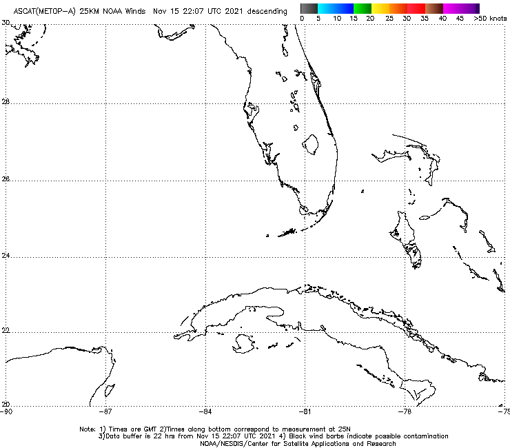
Dang I suck.
This is the latest descending pass. So sorry
Last edited by HurriGuy on Mon Aug 29, 2016 2:43 pm, edited 2 times in total.
3 likes
The posts in this forum are NOT official forecast and should not be used as such. They are just the opinion of the poster and may or may not be backed by sound meteorological data. They are NOT endorsed by any professional institution or storm2k.org. For official information, please refer to the NHC and NWS products.
Who is online
Users browsing this forum: No registered users and 42 guests