Fish and Fish
Moderator: S2k Moderators
Forum rules

The posts in this forum are NOT official forecasts and should not be used as such. They are just the opinion of the poster and may or may not be backed by sound meteorological data. They are NOT endorsed by any professional institution or STORM2K. For official information, please refer to products from the National Hurricane Center and National Weather Service.

Fish and Fish
Two fishes ...gulf and carib is where the action will be if any. Enjoy your weekend.
0 likes
-
Rainband
Re: Fish and Fish
tatar sauce or cocktailjfaul wrote:Two fishes ...gulf and carib is where the action will be if any. Enjoy your weekend.
0 likes
Re: Fish and Fish
Rainband wrote:tatar sauce or cocktailjfaul wrote:Two fishes ...gulf and carib is where the action will be if any. Enjoy your weekend.
tarter for juan and cocktail for kate
0 likes
-
Rainband
Re: Fish and Fish
jfaul wrote:Rainband wrote:tatar sauce or cocktailjfaul wrote:Two fishes ...gulf and carib is where the action will be if any. Enjoy your weekend.
tarter for juan and cocktail for kate
0 likes
-
Josephine96
-
WeatherEmperor
- S2K Supporter

- Posts: 4806
- Age: 41
- Joined: Thu Sep 04, 2003 2:54 pm
- Location: South Florida
-
Stormsfury

- Category 5

- Posts: 10549
- Age: 53
- Joined: Wed Feb 05, 2003 6:27 pm
- Location: Summerville, SC
WeatherEmperor wrote:Nah. Kate is most likely going to be a fish. It is way too late to be affected by a Cape Verde system so late in the season. Now the Carib is another story.
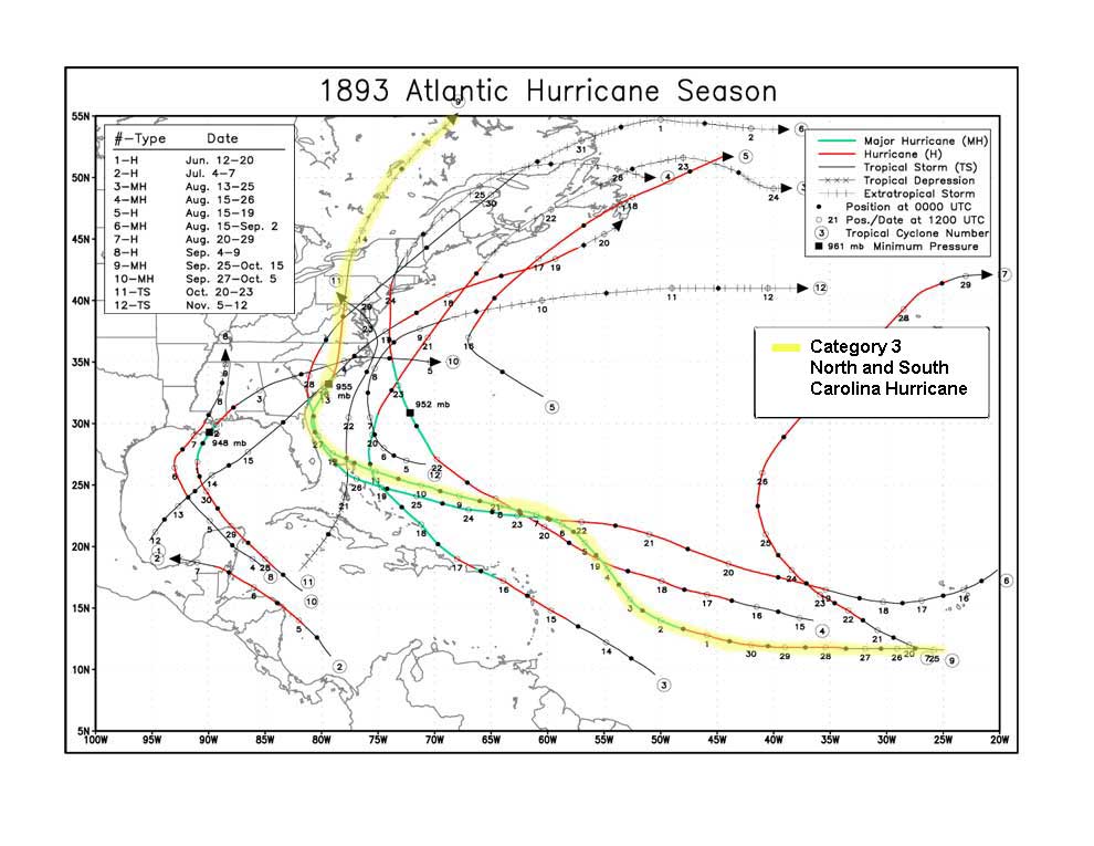
Remember, this is 2003 ... the same was said for Ana in April ... and the earliest Tropical Depression (#2) of record for so far east (even though nothing came of it). History has shown us that it has happened once before. Storm #9 in 1893 which struck South Carolina developed on 9/25/1893 (as a 40 mph tropical storm at 11.6ºN, and 25.0ºW) and became a hurricane east of 35ºW (specifically 11.7ºN, 33.6ºW). It hit South Carolina, just east of Charleston, SC as a 120 mph, 955 mb (estimated) CAT 3 hurricane on October 13th, 1893 and was the second of two major hurricanes to hit South Carolina that year (the first was the Sea Islands Hurricane which was believed to have killed 1,000-2,000 people along GA/SC)
http://www.stormsfury1.com/Weather/Trop ... s/1893.jpg
http://www.stormsfury1.com/Weather/Trop ... s/1893.txt
I'm not saying that's gonna happen. Personally, I don't think that it will happen at this time. But it's too early IMO to declare #16 a fish when it's just beginning to take shape.
SF
0 likes
-
ColdFront77

-
Stormsfury
- Category 5
- Posts: 10549
- Age: 53
- Joined: Wed Feb 05, 2003 6:27 pm
- Location: Summerville, SC

Re: Fish and Fish
jfaul wrote:Two fishes ...gulf and carib is where the action will be if any.
This is a reasonable assumption.
0 likes

-
Aquawind

- Category 5
- Posts: 6714
- Age: 62
- Joined: Mon Jun 16, 2003 10:41 pm
- Location: Salisbury, NC
- Contact:
5am discussion..not a done deal yet.
UNTIL A WELL-DEFINED CENTER BECOMES APPARENT...
THE FUTURE TRACK WILL REMAIN UNCERTAIN. THE RIGHTMOST GFS MODEL
IMMEDIATELY TAKES THE CYCLONE RAPIDLY NORTH-NORTHWESTWARD...WHICH
DOES NOT APPEAR LIKELY GIVEN THE PAST AND CURRENT SATELLITE MOTION
TRENDS. THE REST OF THE NHC GUIDANCE IS SLOWER AND QUITE DIVERGENT
TOWARD THE NORTHWEST OR WEST-NORTHWEST...WITH MOST STILL INDICATING
RECURVATURE IN 72-96 HOURS. THE OFFICIAL FORECAST TRACK IS SLIGHTLY
TO THE LEFT OF AND SLOWER THAN THE PREVIOUS FORECAST TRACK...AND
VERY CLOSE TO THE UKMET AND MEDIUM BAM CONSENSUS. IF TD-16
DEVELOPS/REMAINS FARTHER SOUTH... THEN IT MAY NOT GET FAR ENOUGH
NORTH TO GET PICKED UP BY THE LARGE TROUGH THAT IS FORECAST TO DIG
SOUTHWESTWARD AND WEAKEN THE SUBTROPICAL RIDGE AXIS TO THE NORTH OF
THE CYCLCONE IN 48 TO 72 HOURS.
ENVIRONMENTAL CONDITIONS ARE FORECAST OT REMAIN ONLY MARGINALLY
FAVORABLE FOR SOME SLOW STRENGTHENING TO OCCUR...SO THE SHIPS MODEL
WAS CLOSELY FOLLOWED. HOWEVER...IF THE CYCLONE REMAINS FARTHER
SOUTH THAN FORECAST...THE VERTICAL SHEAR WILL BE MUCH LESS...AND
MORE STRENGTHENING WOULD BE POSSIBLE.
FORECASTER STEWART
Fish is a more likely scenario this late in the season.. sooner or later we shall see.
0 likes
Who is online
Users browsing this forum: No registered users and 46 guests