Could the LLC be having a fujiwara reaction with the MLC? The darn tng is moving SW, even as the MLC stays where it is.
This storm makes no sense. 09L.exe has crashed.
ATL: HERMINE - Post-Tropical - Discussion
Moderator: S2k Moderators
-
Hurricane Andrew

- S2K Supporter

- Posts: 1891
- Age: 27
- Joined: Sun May 23, 2010 2:53 pm
- Location: KS
Re: ATL: NINE - Tropical Depression - Discussion
0 likes
The Enthusiast
NREMT-AEMT, WX nerd
Irene '11, Sandy '12, Irma '17 (SAR)
"Hard to think we were born to live this way..." -Wage War
-
SunnyThoughts
- Category 5

- Posts: 2263
- Joined: Wed Jul 09, 2003 12:42 pm
- Location: Pensacola, Florida
Re: ATL: NINE - Tropical Depression - Discussion
Depression 09L
UW-CIMSS Automated Satellite-Based
Advanced Dvorak Technique (ADT)
Version 8.2.1
Tropical Cyclone Intensity Estimation Algorithm
Current Intensity Analysis
UW - CIMSS
ADVANCED DVORAK TECHNIQUE
ADT-Version 8.2.1
Tropical Cyclone Intensity Algorithm
----- Current Analysis -----
Date : 30 AUG 2016 Time : 214500 UTC
Lat : 24:25:48 N Lon : 87:20:20 W
CI# /Pressure/ Vmax
3.3 / 992.8mb/ 51.0kt
Final T# Adj T# Raw T#
3.3 3.6 3.7
0 likes
Re: ATL: NINE - Tropical Depression - Discussion
Siker wrote:Hammy wrote:Aric Dunn wrote:the wind over in the far east quad are not flowing inward. they should s to se but rather they are S to SW. very odd.
This is probably going to degenerate into a trough as the models a few days ago showed, and that indicates that process is beginning--there's essentially little to no convergence going on by the looks of it. I still don't think this will ever get any stronger and there's nothing out there, aside from model speculation, that gives any indication otherwise.
Weird times we live in when every model calling for intensification counts as "nothing". Then again, I guess it depends who you ask.
I'll bet several fake dollars this gets named.
I think so, too and I have a theory as to why!
I believe they HAVE to name as many as possible, in order to meet their "projected" number of storms they said there would be during a particular year.
Almost a self-fulfilling prophecy type of thing.
0 likes
Cleo - 1964, Betsy - 1965, David - 1979, Andrew - 1992, Charlie (Francis, Ivan, Jeanne) - 2004, Irma - 2017, Ian - 2022, Milton - 2024
-
SouthDadeFish

- Professional-Met

- Posts: 2835
- Joined: Thu Sep 23, 2010 2:54 pm
- Location: Miami, FL
- Contact:
Re: ATL: NINE - Tropical Depression - Discussion
Hurricane Andrew wrote:Could the LLC be having a fujiwara reaction with the MLC? The darn tng is moving SW, even as the MLC stays where it is.
This storm makes no sense. 09L.exe has crashed.
It highly likely is. A local vorticity maximum exists in three dimensions. As you move away from the vorticity maximum, the cyclonic circulation around it decreases. However, the low-level circulation is within range to "feel" the cyclonic flow around and below the mid-level circulation. The rate of rotation around the mid-level circulation depends on the strength of the vortex and how close they are to one another. Conversely, the low-level circulation is acting to rotate the mid-level circulation around cyclonically as well. You must also consider both of these vortices are embedded in a background flow, causing their cyclonic rotation around one another to be less clear. It is a complicated process, but I hope this explanation helps.
3 likes
-
Soonercane
Re: ATL: NINE - Tropical Depression - Discussion
Hammy wrote:Alyono wrote:convection needs to stop wrapping around the MLC in order for it to die. It's forming a rainband around the MLC
This is why I disagree with a Hurricane Watch. I thought a TS watch was enough for now
Is this acting similarly to Gabrielle in 2013 when it was over Puerto Rico with the MLC actually pulling energy away from the LLC?
Good analogy, I do think it will get named but I would bet it doesn't get over 45 knots
0 likes

Re: ATL: NINE - Tropical Depression - Discussion
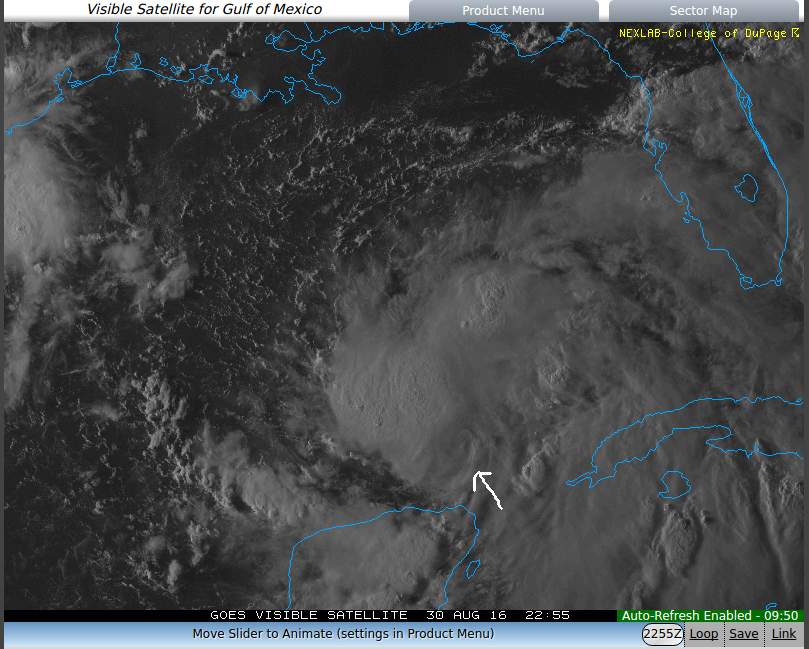
Nasty view as the sun goes down
LOOP
http://climate.cod.edu/hanis/satellite/ ... o-vis-1-24
http://climate.cod.edu/hanis/satellite/ ... verDim=100
LOOP
http://climate.cod.edu/hanis/satellite/ ... o-vis-1-24
http://climate.cod.edu/hanis/satellite/ ... verDim=100
3 likes
-
Hurricane Andrew
- S2K Supporter
- Posts: 1891
- Age: 27
- Joined: Sun May 23, 2010 2:53 pm
- Location: KS
Re: ATL: NINE - Tropical Depression - Discussion
SouthDadeFish wrote:Hurricane Andrew wrote:Could the LLC be having a fujiwara reaction with the MLC? The darn tng is moving SW, even as the MLC stays where it is.
This storm makes no sense. 09L.exe has crashed.
It highly likely is. A local vorticity maximum exists in three dimensions. As you move away from the vorticity maximum, the cyclonic circulation around it decreases. However, the low-level circulation is within range to "feel" the cyclonic flow around and below the mid-level circulation. The rate of rotation around the mid-level circulation depends on the strength of the vortex and how close they are to one another. Conversely, the low-level circulation is acting to rotate the mid-level circulation around cyclonically as well. You must also consider both of these vortices are embedded in a background flow, causing their cyclonic rotation around one another to be less clear. It is a complicated process, but I hope this explanation helps.
It does, thank you. It makes a lot of sense actually. Considering that the LLC has been moving while the MLC stays stationary, this is definately a lopsided reaction. The blossoming convection is about to cover both. The whole thing might pull together, but it has limited time to do so IMO.
0 likes
The Enthusiast
NREMT-AEMT, WX nerd
Irene '11, Sandy '12, Irma '17 (SAR)
"Hard to think we were born to live this way..." -Wage War

Re: ATL: NINE - Tropical Depression - Discussion
Alyono wrote:convection needs to stop wrapping around the MLC in order for it to die. It's forming a rainband around the MLC
This is why I disagree with a Hurricane Watch. I thought a TS watch was enough for now
Amen! this was issued 48 hours out plenty of time to evacuate so a TS watch til tomorrow would have been fine I think also.
0 likes
Robbielyn McCrary
I know just about enough to sound like I know what I'm talking about sometimes. But for your safety please follow the nhc for truly professional forecasting.
I know just about enough to sound like I know what I'm talking about sometimes. But for your safety please follow the nhc for truly professional forecasting.
-
drewschmaltz
- S2K Supporter
- Posts: 351
- Joined: Thu Aug 27, 2015 8:19 pm
Re: ATL: NINE - Tropical Depression - Discussion
Soonercane wrote:Hammy wrote:Alyono wrote:convection needs to stop wrapping around the MLC in order for it to die. It's forming a rainband around the MLC
This is why I disagree with a Hurricane Watch. I thought a TS watch was enough for now
Is this acting similarly to Gabrielle in 2013 when it was over Puerto Rico with the MLC actually pulling energy away from the LLC?
Good analogy, I do think it will get named but I would bet it doesn't get over 45 knots
NHC, forum mets, and models say otherwise. I will take that bet and say 50knots inside 18 hours.
Last edited by drewschmaltz on Tue Aug 30, 2016 6:26 pm, edited 1 time in total.
0 likes
I HAVE ABSOLUTELY NO IDEA WHAT I'M TALKING ABOUT. PLEASE CONSULT SOMEONE WHO DOES. START WITH THE NHC. ALL POSTS ARE FOR ENTERTAINMENT PURPOSES ONLY.

Re: ATL: NINE - Tropical Depression - Discussion
The ULL north of Hispaniola is just about to grab the outflow of TD9 and ventilate it with a second outflow channel.
http://tropic.ssec.wisc.edu/real-time/a ... g8wvir.GIF
http://tropic.ssec.wisc.edu/real-time/a ... g8wvir.GIF
1 likes
-
AutoPenalti
- Category 5
- Posts: 4091
- Age: 29
- Joined: Mon Aug 17, 2015 4:16 pm
- Location: Ft. Lauderdale, Florida
Re: ATL: NINE - Tropical Depression - Discussion
TJRE wrote:Nasty view as the sun goes down
LOOP
http://climate.cod.edu/hanis/satellite/ ... o-vis-1-24
http://climate.cod.edu/hanis/satellite/ ... verDim=100
WARNING: That picture is NSFW.
1 likes
The posts in this forum are NOT official forecasts and should not be used as such. They are just the opinion of the poster and may or may not be backed by sound meteorological data. They are NOT endorsed by any professional institution or STORM2K. For official information, please refer to products from the NHC and NWS.
Model Runs Cheat Sheet:
GFS (5:30 AM/PM, 11:30 AM/PM)
HWRF, GFDL, UKMET, NAVGEM (6:30-8:00 AM/PM, 12:30-2:00 AM/PM)
ECMWF (1:45 AM/PM)
TCVN is a weighted averaged
-
SouthDadeFish
- Professional-Met
- Posts: 2835
- Joined: Thu Sep 23, 2010 2:54 pm
- Location: Miami, FL
- Contact:
Re: ATL: NINE - Tropical Depression - Discussion
Something to keep in mind about the mid-level centers... They are typically generated from prior convection. The exposed mid-level center off to the SE everyone is observing now was created by the last night's convective burst. As the convection faded, the vorticity remains, and will do so until it is mixed out. This new convective burst has the potential to create a new mid-level circulation if it persists. It is the nature of convection and latent heat release. It generates vorticity.
If the new convective burst can remain aligned with the low-level center (something that hasn't happened thus far), then mid-level vorticity will be generated over the LLC. For the most part, the current convective burst has been aligned with the LLC. This will be something to keep an eye on in the overnight hours. If convection remains aligned with the LLC, this will help to vertically stack the TC.
If the new convective burst can remain aligned with the low-level center (something that hasn't happened thus far), then mid-level vorticity will be generated over the LLC. For the most part, the current convective burst has been aligned with the LLC. This will be something to keep an eye on in the overnight hours. If convection remains aligned with the LLC, this will help to vertically stack the TC.
6 likes
-
TropicalAnalystwx13

- Category 5
- Posts: 2109
- Age: 28
- Joined: Tue Jul 19, 2011 8:20 pm
- Location: Wilmington, NC
- Contact:
Re: ATL: NINE - Tropical Depression - Discussion
Hammy wrote:Aric Dunn wrote:the wind over in the far east quad are not flowing inward. they should s to se but rather they are S to SW. very odd.
This is probably going to degenerate into a trough as the models a few days ago showed, and that indicates that process is beginning--there's essentially little to no convergence going on by the looks of it. I still don't think this will ever get any stronger and there's nothing out there, aside from model speculation, that gives any indication otherwise.
The National Hurricane Center would not have hurricane watches up and be forecasting a strong tropical storm landfall if there weren't indications otherwise. They know what they're doing.
Nine is organizing this evening. The LLC and MLC are as close as they've ever been, pressures are slowly falling, and convection continues to build.
3 likes

Re: ATL: NINE - Tropical Depression - Discussion
Where is this big turn to North that is suppose to be happening?
Edit: On a side note the Mid Level winds are blowing NNW here in South Louisiana.
Edit: On a side note the Mid Level winds are blowing NNW here in South Louisiana.
0 likes
Personal Forecast Disclaimer:
The posts in this forum are NOT official forecast and should not be used as such. They are just the opinion of the poster and may or may not be backed by sound meteorological data. They are NOT endorsed by any professional institution or storm2k.org. For official information, please refer to the NHC and NWS products.
The posts in this forum are NOT official forecast and should not be used as such. They are just the opinion of the poster and may or may not be backed by sound meteorological data. They are NOT endorsed by any professional institution or storm2k.org. For official information, please refer to the NHC and NWS products.

Re: ATL: NINE - Tropical Depression - Discussion
SouthDadeFish wrote:Something to keep in mind about the mid-level centers... They are typically generated from prior convection. The exposed mid-level center off to the SE everyone is observing now was created by the last night's convective burst. As the convection faded, the vorticity remains, and will do so until it is mixed out. This new convective burst has the potential to create a new mid-level circulation if it persists. It is the nature of convection and latent heat release. It generates vorticity.
If the new convective burst can remain aligned with the low-level center (something that hasn't happened thus far), then mid-level vorticity will be generated over the LLC. For the most part, the current convective burst has been aligned with the LLC. This will be something to keep an eye on in the overnight hours. If convection remains aligned with the LLC, this will help to vertically stack the TC.
... and in essence likely pull the old MLC, BUT might that feature potentially be fully absorbed or potentially rotate around any vertically stacked core as a "vorticity max" type feature?
0 likes
Andy D
(For official information, please refer to the NHC and NWS products.)
(For official information, please refer to the NHC and NWS products.)
-
hohnywx
- Category 2

- Posts: 511
- Age: 35
- Joined: Sun Jul 19, 2009 8:34 pm
- Location: Hastings-on-Hudson, NY
Re: ATL: NINE - Tropical Depression - Discussion
robbielyn wrote:Alyono wrote:convection needs to stop wrapping around the MLC in order for it to die. It's forming a rainband around the MLC
This is why I disagree with a Hurricane Watch. I thought a TS watch was enough for now
Amen! this was issued 48 hours out plenty of time to evacuate so a TS watch til tomorrow would have been fine I think also.
What? The NHC rules state that a watch is issued 48 hours in advance of either TS or Hurricane conditions. We are less than 48 hours away from conditions potentially arriving at the Florida coast.
0 likes
-
TropicalAnalystwx13
- Category 5
- Posts: 2109
- Age: 28
- Joined: Tue Jul 19, 2011 8:20 pm
- Location: Wilmington, NC
- Contact:
Re: ATL: NINE - Tropical Depression - Discussion
Blinhart wrote:Where is this big turn to North that is suppose to be happening?
Edit: On a side note the Mid Level winds are blowing NNW here in South Louisiana.
It's already beginning a northwest motion. It should turn north overnight and northeast by tomorrow evening.
0 likes
Re: ATL: NINE - Tropical Depression - Discussion
I was under the impression that only 36 hr.s were required in advance of T.S. force conditions, but 48 hr. for hurricane force.
0 likes
Andy D
(For official information, please refer to the NHC and NWS products.)
(For official information, please refer to the NHC and NWS products.)
Re: ATL: NINE - Tropical Depression - Discussion
TropicalAnalystwx13 wrote:Blinhart wrote:Where is this big turn to North that is suppose to be happening?
Edit: On a side note the Mid Level winds are blowing NNW here in South Louisiana.
It's already beginning a northwest motion. It should turn north overnight and northeast by tomorrow evening.
When does the Recon get back in there to show that the center is still further South.
0 likes
Personal Forecast Disclaimer:
The posts in this forum are NOT official forecast and should not be used as such. They are just the opinion of the poster and may or may not be backed by sound meteorological data. They are NOT endorsed by any professional institution or storm2k.org. For official information, please refer to the NHC and NWS products.
The posts in this forum are NOT official forecast and should not be used as such. They are just the opinion of the poster and may or may not be backed by sound meteorological data. They are NOT endorsed by any professional institution or storm2k.org. For official information, please refer to the NHC and NWS products.
-
SouthDadeFish
- Professional-Met
- Posts: 2835
- Joined: Thu Sep 23, 2010 2:54 pm
- Location: Miami, FL
- Contact:
Re: ATL: NINE - Tropical Depression - Discussion
chaser1 wrote:... and in essence likely pull the old MLC, BUT might that feature potentially be fully absorbed or potentially rotate around any vertically stacked core as a "vorticity max" type feature?
The old mid-level vorticity maximum will remain present until it is either mixed out through turbulent processes and/or merged with a new mid-level center. It will likely be a gradual process.
0 likes
Who is online
Users browsing this forum: No registered users and 31 guests