UW - CIMSS
ADVANCED DVORAK TECHNIQUE
ADT-Version 8.2.1
Tropical Cyclone Intensity Algorithm
----- Current Analysis -----
Date : 31 AUG 2016 Time : 121500 UTC
Lat : 24:46:57 N Lon : 88:02:19 W
CI# /Pressure/ Vmax
3.6 / 988.7mb/ 57.0kt
Final T# Adj T# Raw T#
3.6 3.8 4.2
Center Temp : -70.1C Cloud Region Temp : -73.3C
Scene Type : EMBEDDED CENTER CLOUD REGION
Positioning Method : FORECAST INTERPOLATION
Ocean Basin : ATLANTIC
Dvorak CI > MSLP Conversion Used : CKZ Method
Tno/CI Rules : Constraint Limits : 0.5T/hour
Weakening Flag : ON
Rapid Dissipation Flag : OFF
C/K/Z MSLP Estimate Inputs :
- Average 34 knot radii : N/A
- Environmental MSLP : 1011mb
Satellite Name : GOES13
Satellite Viewing Angle : 32.4 degrees
Overdone but even it agrees satellite presentation is good.
ATL: HERMINE - Post-Tropical - Discussion
Moderator: S2k Moderators
-
tarheelprogrammer

- S2K Supporter

- Posts: 1793
- Joined: Mon Mar 28, 2016 9:25 pm
- Location: Raleigh, NC area (Garner, NC)
Re: ATL: NINE - Tropical Depression - Discussion
0 likes
My posts are not official forecasts. They are just my opinion and may or may not be backed by sound meteorological data. They are NOT endorsed by any professional institution or storm2k.org. For official information, please refer to the NHC and NWS products.

Re: ATL: NINE - Tropical Depression - Discussion
This is where I believe the LLC is near 24.2N & 88.2W, in red.
The MLC I have it just to the east of it, in blue.
The Circulation looks like is elongated SW to NE.
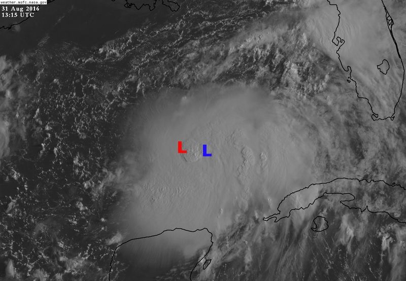
The MLC I have it just to the east of it, in blue.
The Circulation looks like is elongated SW to NE.
Last edited by NDG on Wed Aug 31, 2016 8:47 am, edited 1 time in total.
0 likes
-
MGC

- S2K Supporter
- Posts: 5940
- Joined: Sun Mar 23, 2003 9:05 pm
- Location: Pass Christian MS, or what is left.
Re: ATL: NINE - Tropical Depression - Discussion
09L has an impressive satellite presentation this morning.....likely a TS now. Sure wish it would get moving. I hate when tropical cyclones sit and fester. More time over water increases the odds of a hurricane at landfall IMO......MGC
4 likes
Re: ATL: NINE - Tropical Depression - Discussion
JaxGator wrote:Has anyone seen this recent ASCAT pass? It's 3 hours old so it might look different by now.
https://pbs.twimg.com/media/CrLpdjFWEAA2jDm.jpg
Is 10 hours old, not 3 hours, time stamp on the bottom in UTC.
1 likes
Re: ATL: NINE - Recon Discussion
NOAA43 was to take off at 1130Z but not yet airborne, apparently due to mechanical or technical problems...
0 likes
-
Aric Dunn
- Category 5

- Posts: 21238
- Age: 43
- Joined: Sun Sep 19, 2004 9:58 pm
- Location: Ready for the Chase.
- Contact:
Re: ATL: NINE - Tropical Depression - Discussion
with the only two notable curved bands the center appears to be just north of 24N still around 87.5W. We may see some fairly rapid intensification today.

1 likes
Note: If I make a post that is brief. Please refer back to previous posts for the analysis or reasoning. I do not re-write/qoute what my initial post said each time.
If there is nothing before... then just ask
Space & Atmospheric Physicist, Embry-Riddle Aeronautical University,
I believe the sky is falling...
If there is nothing before... then just ask
Space & Atmospheric Physicist, Embry-Riddle Aeronautical University,
I believe the sky is falling...
-
tropicwatch

- Category 5
- Posts: 3426
- Age: 62
- Joined: Sat Jun 02, 2007 10:01 am
- Location: The Villages, Florida
- Contact:
Re: ATL: NINE - Tropical Depression - Discussion
[quote="NDG"]This is where I believe the LLC is near 18.2N & 88.2W, in red.
The MLC I have it just to the east of it, in blue.
The Circulation looks like is elongated SW to NE.
You mean 24.2N
The MLC I have it just to the east of it, in blue.
The Circulation looks like is elongated SW to NE.
You mean 24.2N
0 likes
Tropicwatch
Agnes 72', Eloise 75, Elena 85', Kate 85', Charley 86', Florence 88', Beryl 94', Dean 95', Erin 95', Opal 95', Earl 98', Georges 98', Ivan 2004', Arlene 2005', Dennis 2005', Ida 2009' Debby 2012' Irma 2017' Michael 2018'
Agnes 72', Eloise 75, Elena 85', Kate 85', Charley 86', Florence 88', Beryl 94', Dean 95', Erin 95', Opal 95', Earl 98', Georges 98', Ivan 2004', Arlene 2005', Dennis 2005', Ida 2009' Debby 2012' Irma 2017' Michael 2018'
Re: ATL: NINE - Tropical Depression - Discussion
TS wind pros for the Tampa Bay area went down with the last advisory so the decision not to include them in a watch area looks good so far. If the track edges more to the west those already low odds will drop more. Any eastward shift and warnings can be extended down the coast. Regardless the real hazard has always been and continues to remain heavy rain. A flood watch is out for 8-12" of rain expected. The hazards for the bay area are well advertised for those with eyes to see and ears to hear and they always have been. I have to sift through a lot of junk on this forum to find stuff of value. That's unfortunate
1 likes
-
tigerz3030
- Tropical Depression

- Posts: 64
- Joined: Tue Aug 23, 2016 4:38 pm
Re: ATL: NINE - Tropical Depression - Discussion
With it tilted SW to NE, will it start going more NE sooner?
2 likes

Re: ATL: NINE - Tropical Depression - Discussion
tarheelprogrammer wrote:UW - CIMSS
ADVANCED DVORAK TECHNIQUE
ADT-Version 8.2.1
Tropical Cyclone Intensity Algorithm
----- Current Analysis -----
Date : 31 AUG 2016 Time : 121500 UTC
Lat : 24:46:57 N Lon : 88:02:19 W
CI# /Pressure/ Vmax
3.6 / 988.7mb/ 57.0kt
Final T# Adj T# Raw T#
3.6 3.8 4.2
Center Temp : -70.1C Cloud Region Temp : -73.3C
Scene Type : EMBEDDED CENTER CLOUD REGION
Positioning Method : FORECAST INTERPOLATION
Ocean Basin : ATLANTIC
Dvorak CI > MSLP Conversion Used : CKZ Method
Tno/CI Rules : Constraint Limits : 0.5T/hour
Weakening Flag : ON
Rapid Dissipation Flag : OFF
C/K/Z MSLP Estimate Inputs :
- Average 34 knot radii : N/A
- Environmental MSLP : 1011mb
Satellite Name : GOES13
Satellite Viewing Angle : 32.4 degrees
Overdone but even it agrees satellite presentation is good.
With this, the ship reporting the 43 MPH wind, do you think they might up this to at least a 40 MPH TS or wait the 3 or 4 hours for Recon to get in there and might find a system that is starting to bomb out and it is already at 65 MPH and pressure down to like 985. I think right now it is probably a 45MPH TS with a pressure around 998. Looks like it could be starting to ramp up.
2 likes
Personal Forecast Disclaimer:
The posts in this forum are NOT official forecast and should not be used as such. They are just the opinion of the poster and may or may not be backed by sound meteorological data. They are NOT endorsed by any professional institution or storm2k.org. For official information, please refer to the NHC and NWS products.
The posts in this forum are NOT official forecast and should not be used as such. They are just the opinion of the poster and may or may not be backed by sound meteorological data. They are NOT endorsed by any professional institution or storm2k.org. For official information, please refer to the NHC and NWS products.


Re: ATL: NINE - Tropical Depression - Discussion
NDG wrote:JaxGator wrote:Has anyone seen this recent ASCAT pass? It's 3 hours old so it might look different by now.
https://pbs.twimg.com/media/CrLpdjFWEAA2jDm.jpg
Is 10 hours old, not 3 hours, time stamp on the bottom in UTC.
Opps..sorry. My bad. Got it from a tweet Michael Ventrice posted.
1 likes
The posts or stuff said are NOT an official forecast. Please look to the NHC and NWS for official forecasts and products.
Floyd-1999, Frances-2004, Jeanne-2004, Fay-2008, Beryl-2012, Debby-2012, Colin-2016, Hermine-2016, Julia-2016, Matthew-2016, Irma-2017, Elsa-2021, Idalia-2023, Debby-2024, Helene-2024.
Go Gators! Go Jags!
Floyd-1999, Frances-2004, Jeanne-2004, Fay-2008, Beryl-2012, Debby-2012, Colin-2016, Hermine-2016, Julia-2016, Matthew-2016, Irma-2017, Elsa-2021, Idalia-2023, Debby-2024, Helene-2024.
Go Gators! Go Jags!
-
tropicwatch
- Category 5
- Posts: 3426
- Age: 62
- Joined: Sat Jun 02, 2007 10:01 am
- Location: The Villages, Florida
- Contact:
Re: ATL: NINE - Recon Discussion
Looks like they have one scheduled to take off at 11am central time.
1. TROPICAL DEPRESSION NINE (GULF OF MEXICO)
FLIGHT ONE - NOAA 43 FLIGHT TWO - NOAA 43
A. 31/1730Z,2330Z A. 01/0530Z,1130Z
B. NOAA3 1109A CYCLONE B. NOAA3 1209A CYCLONE
C. 31/1600Z C. 01/0400Z
D. 26.3N 86.7W D. 27.5N 85.5W
E. 31/1700Z TO 31/2330Z E. 01/0500Z TO 01/1130Z
F. SFC TO 10,000 FT F. SFC TO 10,000 FT
0 likes
Tropicwatch
Agnes 72', Eloise 75, Elena 85', Kate 85', Charley 86', Florence 88', Beryl 94', Dean 95', Erin 95', Opal 95', Earl 98', Georges 98', Ivan 2004', Arlene 2005', Dennis 2005', Ida 2009' Debby 2012' Irma 2017' Michael 2018'
Agnes 72', Eloise 75, Elena 85', Kate 85', Charley 86', Florence 88', Beryl 94', Dean 95', Erin 95', Opal 95', Earl 98', Georges 98', Ivan 2004', Arlene 2005', Dennis 2005', Ida 2009' Debby 2012' Irma 2017' Michael 2018'
-
tarheelprogrammer
- S2K Supporter
- Posts: 1793
- Joined: Mon Mar 28, 2016 9:25 pm
- Location: Raleigh, NC area (Garner, NC)
Re: ATL: NINE - Tropical Depression - Discussion
Blinhart wrote:tarheelprogrammer wrote:UW - CIMSS
ADVANCED DVORAK TECHNIQUE
ADT-Version 8.2.1
Tropical Cyclone Intensity Algorithm
----- Current Analysis -----
Date : 31 AUG 2016 Time : 121500 UTC
Lat : 24:46:57 N Lon : 88:02:19 W
CI# /Pressure/ Vmax
3.6 / 988.7mb/ 57.0kt
Final T# Adj T# Raw T#
3.6 3.8 4.2
Center Temp : -70.1C Cloud Region Temp : -73.3C
Scene Type : EMBEDDED CENTER CLOUD REGION
Positioning Method : FORECAST INTERPOLATION
Ocean Basin : ATLANTIC
Dvorak CI > MSLP Conversion Used : CKZ Method
Tno/CI Rules : Constraint Limits : 0.5T/hour
Weakening Flag : ON
Rapid Dissipation Flag : OFF
C/K/Z MSLP Estimate Inputs :
- Average 34 knot radii : N/A
- Environmental MSLP : 1011mb
Satellite Name : GOES13
Satellite Viewing Angle : 32.4 degrees
Overdone but even it agrees satellite presentation is good.
With this, the ship reporting the 43 MPH wind, do you think they might up this to at least a 40 MPH TS or wait the 3 or 4 hours for Recon to get in there and might find a system that is starting to bomb out and it is already at 65 MPH and pressure down to like 985. I think right now it is probably a 45MPH TS with a pressure around 998. Looks like it could be starting to ramp up.
Almost all METS I have talked to believe this is a TS now and many believe it was late last night/early this morning.
3 likes
My posts are not official forecasts. They are just my opinion and may or may not be backed by sound meteorological data. They are NOT endorsed by any professional institution or storm2k.org. For official information, please refer to the NHC and NWS products.
Re: ATL: NINE - Tropical Depression - Discussion
panamatropicwatch wrote:NDG wrote:This is where I believe the LLC is near 18.2N & 88.2W, in red.
The MLC I have it just to the east of it, in blue.
The Circulation looks like is elongated SW to NE.
You mean 24.2N
Yes, thank you. I will correct.
1 likes
-
benh316
Re: ATL: NINE - Tropical Depression - Discussion
FYI everyone - Governor Rick Scott has issued Executive Order 16-205 declaring a state of emergency in 42 counties within the state of Florida in preparation for Tropical Depression Nine.
Governor Scott said, "Last night, hurricane and tropical storm watches were issued along Florida’s Gulf Coast from Pasco County to Gulf County. We also learned that the National Hurricane Center expects Tropical Depression Nine to become a Tropical Storm sometime today. It is crucial that every Floridian has a plan in place to ensure their families, homes and businesses are fully prepared. Floridians can make their own plan at FLGetaPlan.com. I have been closely monitoring this storm’s development and our emergency management officials have been working hard to make sure we are ready to respond to any potential impacts. By declaring a state of emergency in advance of this storm, we are ensuring that state, regional and local agencies can work together to meet the needs of our communities. We will continue to do all we can to keep our families and visitors safe and informed as this storm approaches our state."
Governor Scott said, "Last night, hurricane and tropical storm watches were issued along Florida’s Gulf Coast from Pasco County to Gulf County. We also learned that the National Hurricane Center expects Tropical Depression Nine to become a Tropical Storm sometime today. It is crucial that every Floridian has a plan in place to ensure their families, homes and businesses are fully prepared. Floridians can make their own plan at FLGetaPlan.com. I have been closely monitoring this storm’s development and our emergency management officials have been working hard to make sure we are ready to respond to any potential impacts. By declaring a state of emergency in advance of this storm, we are ensuring that state, regional and local agencies can work together to meet the needs of our communities. We will continue to do all we can to keep our families and visitors safe and informed as this storm approaches our state."
3 likes
Re: ATL: NINE - Tropical Depression - Discussion
The system has been up and down during it's lifetime (3 hours from now the convection might be gone again), so no doubt the NHC will wait for recon before upgrading. The 43 mph wind reported by a ship might have been in a thunderstorm (we had similar winds here yesterday during a thunderstorm), so not enough for upgrading.
Frank
Frank
Last edited by Frank2 on Wed Aug 31, 2016 8:49 am, edited 1 time in total.
0 likes

Re: ATL: NINE - Tropical Depression - Discussion
Pressure still not doing much at the closest buoy.
I think we still have a few hours for the core to heat up until it really starts to drop.
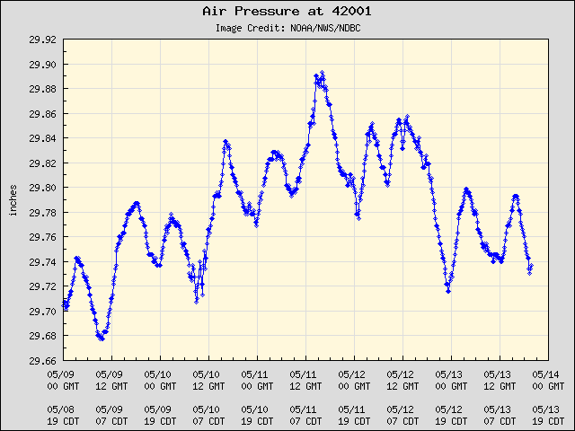
I think we still have a few hours for the core to heat up until it really starts to drop.
0 likes
-
toad strangler

- S2K Supporter
- Posts: 4546
- Joined: Sun Jul 28, 2013 3:09 pm
- Location: Earth
- Contact:
Re: ATL: NINE - Tropical Depression - Discussion
This will be Hermine @ 11AM
2 likes
My Weather Station
https://www.wunderground.com/dashboard/pws/KFLPORTS603
https://www.wunderground.com/dashboard/pws/KFLPORTS603
-
Aric Dunn
- Category 5
- Posts: 21238
- Age: 43
- Joined: Sun Sep 19, 2004 9:58 pm
- Location: Ready for the Chase.
- Contact:
Re: ATL: NINE - Tropical Depression - Discussion
the ship National Glory reported pressure of 1003mb about 20 miles south of the center about an hour ago.
0 likes
Note: If I make a post that is brief. Please refer back to previous posts for the analysis or reasoning. I do not re-write/qoute what my initial post said each time.
If there is nothing before... then just ask
Space & Atmospheric Physicist, Embry-Riddle Aeronautical University,
I believe the sky is falling...
If there is nothing before... then just ask
Space & Atmospheric Physicist, Embry-Riddle Aeronautical University,
I believe the sky is falling...
Re: ATL: NINE - Tropical Depression - Discussion
psyclone wrote:TS wind pros for the Tampa Bay area went down with the last advisory so the decision not to include them in a watch area looks good so far. If the track edges more to the west those already low odds will drop more. Any eastward shift and warnings can be extended down the coast. Regardless the real hazard has always been and continues to remain heavy rain. A flood watch is out for 8-12" of rain expected. The hazards for the bay area are well advertised for those with eyes to see and ears to hear and they always have been. I have to sift through a lot of junk on this forum to find stuff of value. That's unfortunate
Feel free to pass by what you see as junk. Junk posts are in the eye of the beholder. What may be junk for you doesn't mean it's junk for others. My reasoning for my posts stands, you're entitled to your opinion as am I and others. It doesn't make either one of us right. After all, your post doesnt seem needed and could just as easily be deemed as junk. Tolerance is always good. Let's stay on topic now.
Last edited by caneman on Wed Aug 31, 2016 8:58 am, edited 4 times in total.
0 likes
Who is online
Users browsing this forum: No registered users and 66 guests