
Some counties beginning to issue evacuation orders:
https://twitter.com/FloridaTropics1/status/771019564050161664
ATL: HERMINE - Post-Tropical - Discussion
Moderator: S2k Moderators

Re: ATL: NINE - Tropical Depression - Discussion
Dave C wrote:Blinhart wrote:Dave C wrote:Something to think about, the slower this moves towards the coast the better chance of upwelling due to low ocean heat content, especially if it's stronger.
Actually upwelling isn't as much a factor in the Gulf due to the Water temp goes almost all the way to the bottom of the Gulf due to the depth not being as much as the Ocean and not having freezing temps dropping the water temps that much during the winter, so the temps don't fluctuate that much. If I remember correctly.
I'm pretty sure someone mentioned the 26 deg. isotherm is only a short distance below the surface.
It's over 30 Degree temp right now so 26 would be probably around 3 or 4 thousand feet.
1 likes
Personal Forecast Disclaimer:
The posts in this forum are NOT official forecast and should not be used as such. They are just the opinion of the poster and may or may not be backed by sound meteorological data. They are NOT endorsed by any professional institution or storm2k.org. For official information, please refer to the NHC and NWS products.
The posts in this forum are NOT official forecast and should not be used as such. They are just the opinion of the poster and may or may not be backed by sound meteorological data. They are NOT endorsed by any professional institution or storm2k.org. For official information, please refer to the NHC and NWS products.
-
SapphireSea
- Category 1

- Posts: 430
- Joined: Wed Aug 24, 2005 12:13 pm
- Location: Miami, FL
Re: ATL: NINE - Tropical Depression - Discussion
GCANE wrote:Core is improving.
Not quite symmetrically centered on the CoC yet.
But, at 1.5C in the 500 to 400mb area with lower temperatures below which aids parcel ascent.
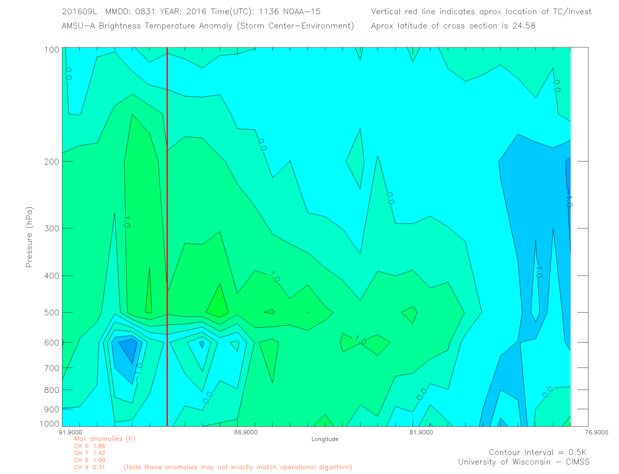
What? I thought warm air rises and not cooler air. That seems like mid level inversion which can suppress convection. Certainly heat should be high if it were warm core which it is.
1 likes
Forecast Disclaimer:
Don't be stupid. Make your own informed decisions.
Don't be stupid. Make your own informed decisions.
-
wsoutherland

- Tropical Low

- Posts: 20
- Joined: Sat Jun 10, 2006 4:14 pm
- Location: Bradenton, FL
- Contact:
Re: ATL: NINE - Tropical Depression - Discussion
Question for you -- Bradenton, west coast of FL here -- it seems that the weather we have moving through here
has a lot more lightning than I remember from near-misses in the past. Any thoughts on why that might be?
https://drive.google.com/file/d/0B6K9OatmRM5ddkNEU0luemNtaVE/view?usp=sharing
https://drive.google.com/file/d/0B6K9OatmRM5dbm9HdVJrVEtCRzg/view?usp=sharing
has a lot more lightning than I remember from near-misses in the past. Any thoughts on why that might be?
https://drive.google.com/file/d/0B6K9OatmRM5ddkNEU0luemNtaVE/view?usp=sharing
https://drive.google.com/file/d/0B6K9OatmRM5dbm9HdVJrVEtCRzg/view?usp=sharing
Last edited by wsoutherland on Wed Aug 31, 2016 11:32 am, edited 1 time in total.
0 likes
Re: ATL: NINE - Tropical Depression - Discussion
Blinhart wrote:Dave C wrote:Something to think about, the slower this moves towards the coast the better chance of upwelling due to low ocean heat content, especially if it's stronger.
Actually upwelling isn't as much a factor in the Gulf due to the Water temp goes almost all the way to the bottom of the Gulf due to the depth not being as much as the Ocean and not having freezing temps dropping the water temps that much during the winter, so the temps don't fluctuate that much. If I remember correctly.
the depression is centered just north of the shelf north of the Yucatan. the water there should be at least 10,000 feet. it's in the deep end of the pool.
1 likes

Re: ATL: NINE - Recon Discussion
panamatropicwatch wrote:Air Force planes will be getting into the act this afternoon.
1. TROPICAL DEPRESSION NINE (GULF OF MEXICO)
FLIGHT ONE - TEAL 71 FLIGHT TWO - TEAL 72
A. 01/0000Z A. 01/1430Z,1730Z,2030Z
B. AFXXX 1109A CYCLONE B. AFXXX 1309A CYCLONE
C. 31/2245Z C. 01/1330Z
D. 26.ON 87.4W D. 27.7N 86.0W
E. 31/2330Z TO 01/0130Z E. 01/1400Z TO 01/2030Z
F. SFC TO 10,000 FT
That's good. They and NOAA will be a great help.
0 likes
The posts or stuff said are NOT an official forecast. Please look to the NHC and NWS for official forecasts and products.
Floyd-1999, Frances-2004, Jeanne-2004, Fay-2008, Beryl-2012, Debby-2012, Colin-2016, Hermine-2016, Julia-2016, Matthew-2016, Irma-2017, Elsa-2021, Idalia-2023, Debby-2024, Helene-2024.
Go Gators! Go Jags!
Floyd-1999, Frances-2004, Jeanne-2004, Fay-2008, Beryl-2012, Debby-2012, Colin-2016, Hermine-2016, Julia-2016, Matthew-2016, Irma-2017, Elsa-2021, Idalia-2023, Debby-2024, Helene-2024.
Go Gators! Go Jags!
-
Chris_in_Tampa
- Category 5

- Posts: 5101
- Age: 42
- Joined: Thu Jun 21, 2007 11:06 pm
- Location: Tampa, Florida, USA
- Contact:
Re: ATL: NINE - Recon Discussion
"3. REMARKS: FLIGHT ONE ABOVE IS A RESOURCES PERMITTING
FIGHT WHICH WAS ADDED."
The Air Force may or may not fly that mission scheduled to depart at 6:45pm EDT this evening. NOAA is on the way now so as long as they can continue perhaps the AF will not.
FIGHT WHICH WAS ADDED."
The Air Force may or may not fly that mission scheduled to depart at 6:45pm EDT this evening. NOAA is on the way now so as long as they can continue perhaps the AF will not.
0 likes
-
TreasureIslandFLGal

- S2K Supporter

- Posts: 1584
- Age: 58
- Joined: Sun Aug 15, 2004 6:16 pm
- Location: Cancun, Mexico (northeast Yucatan coast)
Re: ATL: NINE - Tropical Depression - Discussion
chaser1 wrote:hohnywx wrote:CrazyC83 wrote:When does Recon fly into the storm?
Should be taking off within the next 15 mins.
Are you kidding me????? As if this P3 has been taxiing for the last 1 1/2 hours? What are they doing.... I mean, how much time does it take to load a few box meals for that small crew??
Likely dodging the extreme rains currently getting in the area. the takeoff field could even be experiencing flooding right now.
1 likes
Chrissy & Ligeia

-
ScottNAtlanta

- Category 5
- Posts: 2535
- Joined: Sat May 25, 2013 3:11 pm
- Location: Atlanta, GA
Re: ATL: NINE - Tropical Depression - Discussion
Pressure readings are already down to 1005mb and recon still has got quite a ways to go
(996/45kts)
(996/45kts)
1 likes
The posts in this forum are NOT official forecast and should not be used as such. They are just the opinion of the poster and may or may not be backed by sound meteorological data. They are NOT endorsed by any professional institution or storm2k.org. For official information, please refer to the NHC and NWS products.
-
CrazyC83
- Professional-Met

- Posts: 34315
- Joined: Tue Mar 07, 2006 11:57 pm
- Location: Deep South, for the first time!
Re: ATL: NINE - Recon
000
URNT15 KWBC 311625
NOAA3 1009A CYCLONE HDOB 04 20160831
161600 2651N 08325W 5953 04498 0080 +028 //// 199024 025 027 000 01
161630 2651N 08327W 5950 04503 0082 +027 //// 197025 028 027 000 01
161700 2651N 08330W 5949 04503 0075 +030 //// 200022 022 027 000 01
161730 2651N 08332W 5949 04501 0073 +030 //// 201024 025 029 000 01
161800 2650N 08334W 5949 04499 0069 +032 //// 199024 025 029 000 01
161830 2650N 08337W 5951 04499 0070 +033 +029 200026 026 028 000 00
161900 2650N 08339W 5951 04500 0073 +033 +021 201022 023 027 000 00
161930 2650N 08342W 5950 04499 0068 +034 +025 209019 021 026 000 00
162000 2650N 08344W 5952 04499 0062 +038 +030 203015 016 025 000 00
162030 2649N 08346W 5950 04501 0073 +033 +024 204013 014 028 000 00
162100 2649N 08349W 5951 04499 0071 +034 +022 204011 011 037 003 00
162130 2649N 08351W 5952 04498 0063 +038 +037 192015 021 040 011 00
162200 2649N 08354W 5980 04457 0056 +038 //// 175023 025 034 014 01
162230 2648N 08356W 5966 04470 0052 +039 //// 150020 022 036 002 01
162300 2648N 08359W 5975 04464 0051 +040 //// 163021 022 031 001 01
162330 2648N 08401W 5957 04486 0057 +036 //// 144023 028 028 001 01
162400 2648N 08404W 5994 04433 0058 +037 //// 160027 033 028 001 01
162430 2647N 08406W 6107 04279 0061 +043 //// 160022 024 028 001 01
162500 2647N 08409W 6267 04070 0068 +052 //// 172022 025 028 001 01
162530 2647N 08411W 6446 03838 0077 +063 //// 179029 031 027 004 01
Descent starting.
0 likes
Re: ATL: NINE - Tropical Depression - Discussion
Possibly the 2 low centers are wrestling with each other - as opposed to joining. A hybrid system. I see no other reason for it not strengthening now. Do you?
I am no pro
I am no pro
1 likes
-
OntarioEggplant
- Category 1
- Posts: 312
- Joined: Sun Aug 07, 2016 11:16 am
Re: ATL: NINE - Tropical Depression - Discussion
Consistent >30 KT FL winds well away from the center.
1 likes

Re: ATL: NINE - Tropical Depression - Discussion
GOMEX 26C Isotherm
http://www.aoml.noaa.gov/phod/dataphod1 ... 3god26.png
http://www.aoml.noaa.gov/phod/dataphod1 ... 3god26.png
1 likes
-
SolarBear73
- Tropical Low
- Posts: 12
- Joined: Tue Aug 23, 2016 8:07 pm
Re: ATL: NINE - Tropical Depression - Discussion
Can anyone confirm which direction the storm is currently moving,or is it still stationary?
1 likes

Re: ATL: NINE - Tropical Depression - Discussion
drezee wrote:Over/under on pressure and max flight level winds found by recon...996mb and 54kts...give me your guess
I will compile the list and see who wins! I will donate $10 on behalf of the winner to Storm2K.
4 likes

Re: ATL: NINE - Tropical Depression - Discussion
JaxGator wrote:WJXT was live at Cedar Key and storm surge has already almost covered one the beaches there and is about to cover the roadway right by it. Also, power poles at that beach are being surrounded by water.
Storm surge depends on a lot of different factors but the square miles surface area of the water exposed to wind is the primary "power factor".
Last estimates I heard were high tides 5 ft above normal in some areas.
1 likes
Re: ATL: NINE - Tropical Depression - Discussion
ScottNAtlanta wrote:I'm sticking with 996/45kts on first vortex
BTW...if you get it right...what is the prize?

See above
1 likes
-
SapphireSea
- Category 1
- Posts: 430
- Joined: Wed Aug 24, 2005 12:13 pm
- Location: Miami, FL
Re: ATL: NINE - Tropical Depression - Discussion
wsoutherland wrote:Question for you -- Bradenton, west coast of FL here -- it seems that the weather we have moving through here
has a lot more lightning than I remember from near-misses in the past. Any thoughts on why that might be?
https://drive.google.com/file/d/0B6K9OatmRM5ddkNEU0luemNtaVE/view?usp=sharing
It means that latent CAPE was fairly strong and that widespread convection is going on. Rising air making contact with negatively charged ions. More of a happenstance of the environment. Hail and other things would indicate severely unstable setup
1 likes
Forecast Disclaimer:
Don't be stupid. Make your own informed decisions.
Don't be stupid. Make your own informed decisions.
Re: ATL: NINE - Tropical Depression - Discussion
Nimbus wrote:JaxGator wrote:WJXT was live at Cedar Key and storm surge has already almost covered one the beaches there and is about to cover the roadway right by it. Also, power poles at that beach are being surrounded by water.
Storm surge depends on a lot of different factors but the square miles surface area of the water exposed to wind is the primary "power factor".
Last estimates I heard were high tides 5 ft above normal in some areas.
That's a big rise. The waves are not big yet per say but the water is rising. Locals said on the news that the road would be covered by 2pm.
Last edited by JaxGator on Wed Aug 31, 2016 11:38 am, edited 1 time in total.
1 likes
The posts or stuff said are NOT an official forecast. Please look to the NHC and NWS for official forecasts and products.
Floyd-1999, Frances-2004, Jeanne-2004, Fay-2008, Beryl-2012, Debby-2012, Colin-2016, Hermine-2016, Julia-2016, Matthew-2016, Irma-2017, Elsa-2021, Idalia-2023, Debby-2024, Helene-2024.
Go Gators! Go Jags!
Floyd-1999, Frances-2004, Jeanne-2004, Fay-2008, Beryl-2012, Debby-2012, Colin-2016, Hermine-2016, Julia-2016, Matthew-2016, Irma-2017, Elsa-2021, Idalia-2023, Debby-2024, Helene-2024.
Go Gators! Go Jags!
Who is online
Users browsing this forum: No registered users and 67 guests