ATL: HERMINE - Post-Tropical - Discussion

Moderator: S2k Moderators

Message
Author
Aric Dunn
Category 5
Category 5
Posts: 21238
Age: 43
Joined: Sun Sep 19, 2004 9:58 pm
Location: Ready for the Chase.
Contact:

Re: ATL: HERMINE - Tropical Storm - Discussion

#6881 Postby Aric Dunn » Wed Aug 31, 2016 5:16 pm

JKingTampa wrote:I'm curious as to how much wind Pinellas County might get. I realize the storm is supposed to make landfall quite a bit north but considering the worst of the system is on the south and east sides, with the amount of rain we are receiving.. Even low end tropical storm force winds would bring down trees fairly easy.

you better keep a look out over the next hour big squall coming high winds and maybe weak tornado's.
2 likes   
Note: If I make a post that is brief. Please refer back to previous posts for the analysis or reasoning. I do not re-write/qoute what my initial post said each time.
If there is nothing before... then just ask :)

Space & Atmospheric Physicist, Embry-Riddle Aeronautical University,
I believe the sky is falling...

User avatar
tarheelprogrammer
S2K Supporter
S2K Supporter
Posts: 1793
Joined: Mon Mar 28, 2016 9:25 pm
Location: Raleigh, NC area (Garner, NC)

Re: ATL: HERMINE - Tropical Storm - Discussion

#6882 Postby tarheelprogrammer » Wed Aug 31, 2016 5:17 pm

Appears to be stacked to my untrained eyes.
0 likes   
My posts are not official forecasts. They are just my opinion and may or may not be backed by sound meteorological data. They are NOT endorsed by any professional institution or storm2k.org. For official information, please refer to the NHC and NWS products.

User avatar
TropicalSailor
Tropical Depression
Tropical Depression
Posts: 94
Joined: Thu Aug 25, 2016 8:24 am
Location: Panama City Beach, FL

Re: ATL: HERMINE - Tropical Storm - Discussion

#6883 Postby TropicalSailor » Wed Aug 31, 2016 5:17 pm

OntarioEggplant wrote:
Aric Dunn wrote:heavy squall about to come ashore near tampa. doppler velocities continue to show 50kt plus wind now with plenty of rotation.


Yes I'm afraid this band will be the initial source of tornadoes.


Don't go to the NFL preseason game in Tampa Bay if it isn't already canceled. :eek:
1 likes   

User avatar
alienstorm
Category 1
Category 1
Posts: 496
Joined: Tue Jul 31, 2007 1:29 pm
Location: Miami Fla western suburb

Re: ATL: HERMINE - Tropical Storm - Discussion

#6884 Postby alienstorm » Wed Aug 31, 2016 5:18 pm

Dont know if my eyes are starting to play tricks on me, but it seems to be moving ENE...
0 likes   
Personal Forecast Disclaimer:The posts in this forum are NOT official forecast and should not be used as such. They are just the opinion of the poster and may or may not be backed by sound meteorological data. They are NOT endorsed by any professional institution or storm2k.org. For official information, please refer to the NHC and NWS products.

tolakram
Admin
Admin
Posts: 20050
Age: 62
Joined: Sun Aug 27, 2006 8:23 pm
Location: Florence, KY (name is Mark)

Re: ATL: HERMINE - Tropical Storm - Discussion

#6885 Postby tolakram » Wed Aug 31, 2016 5:18 pm

1 likes   
M a r k
- - - - -
Join us in chat: Storm2K Chatroom Invite. Android and IOS apps also available.

The posts in this forum are NOT official forecasts and should not be used as such. Posts are NOT endorsed by any professional institution or STORM2K.org. For official information and forecasts, please refer to NHC and NWS products.

Aric Dunn
Category 5
Category 5
Posts: 21238
Age: 43
Joined: Sun Sep 19, 2004 9:58 pm
Location: Ready for the Chase.
Contact:

Re: ATL: HERMINE - Tropical Storm - Discussion

#6886 Postby Aric Dunn » Wed Aug 31, 2016 5:18 pm

alienstorm wrote:Dont know if my eyes are starting to play tricks on me, but it seems to be moving ENE...


recon is about to make a pass prelim look the center has moved east again..
1 likes   
Note: If I make a post that is brief. Please refer back to previous posts for the analysis or reasoning. I do not re-write/qoute what my initial post said each time.
If there is nothing before... then just ask :)

Space & Atmospheric Physicist, Embry-Riddle Aeronautical University,
I believe the sky is falling...

User avatar
TropicalSailor
Tropical Depression
Tropical Depression
Posts: 94
Joined: Thu Aug 25, 2016 8:24 am
Location: Panama City Beach, FL

Re: ATL: HERMINE - Tropical Storm - Discussion

#6887 Postby TropicalSailor » Wed Aug 31, 2016 5:19 pm

alienstorm wrote:Dont know if my eyes are starting to play tricks on me, but it seems to be moving ENE...


Don't you dare say that! Aric said it isn't moving!

But in all seriousness I thought the same thing.
1 likes   

tolakram
Admin
Admin
Posts: 20050
Age: 62
Joined: Sun Aug 27, 2006 8:23 pm
Location: Florence, KY (name is Mark)

Re: ATL: HERMINE - Tropical Storm - Discussion

#6888 Postby tolakram » Wed Aug 31, 2016 5:20 pm

alienstorm wrote:Dont know if my eyes are starting to play tricks on me, but it seems to be moving ENE...


You are only seeing the top of the storm. I'm thinking shear might be increasing blowing the tops toward the NE. Remember recon is IN the storm and the center is not moving much.

Image
1 likes   
M a r k
- - - - -
Join us in chat: Storm2K Chatroom Invite. Android and IOS apps also available.

The posts in this forum are NOT official forecasts and should not be used as such. Posts are NOT endorsed by any professional institution or STORM2K.org. For official information and forecasts, please refer to NHC and NWS products.

User avatar
NDG
S2K Supporter
S2K Supporter
Posts: 15473
Joined: Sun Jul 09, 2006 10:14 pm
Location: Orlando, FL

Re: ATL: HERMINE - Tropical Storm - Discussion

#6889 Postby NDG » Wed Aug 31, 2016 5:21 pm

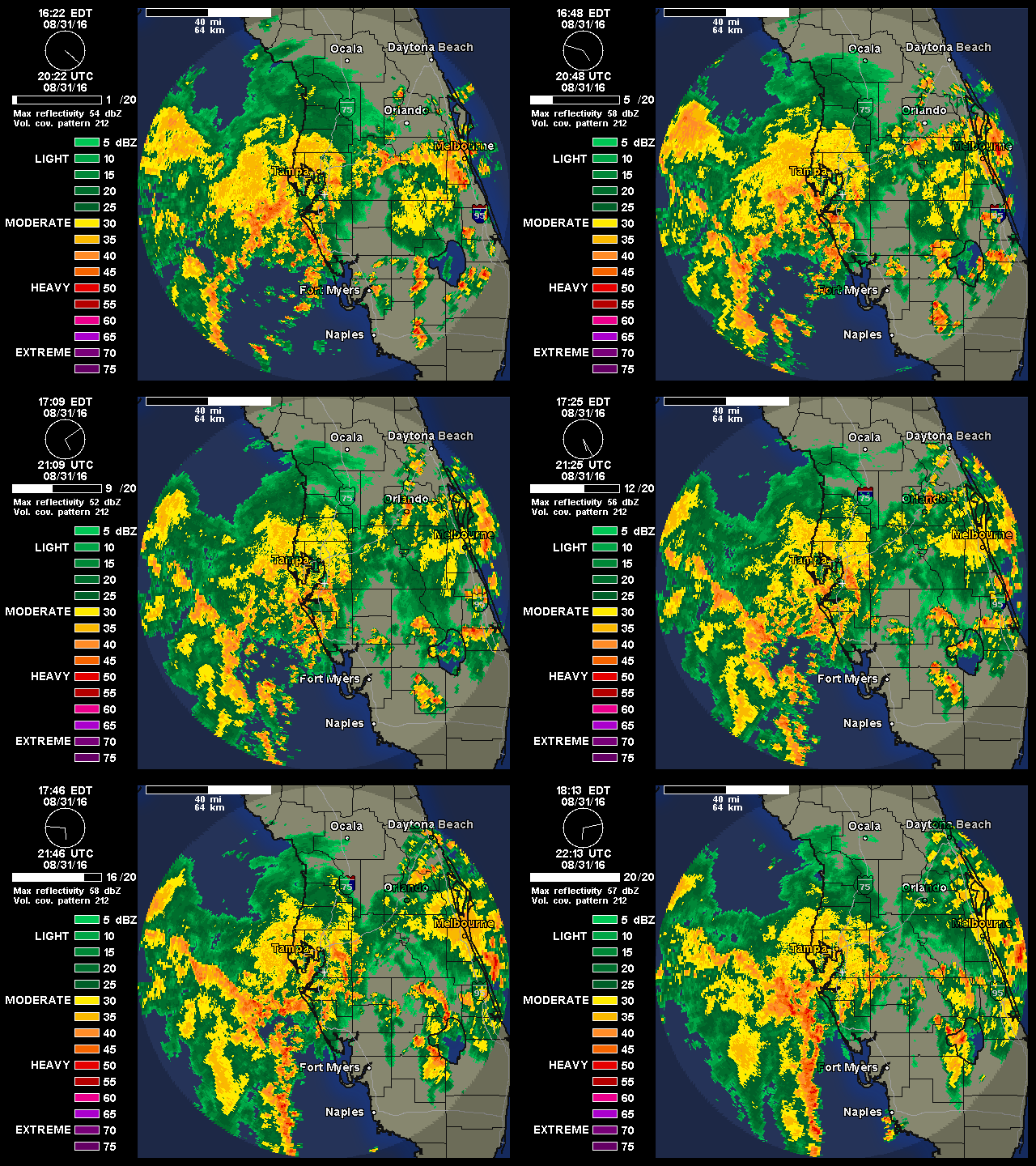
Yet another heavy squall heading toward Tampa Bay.

Image
1 likes   

User avatar
SouthFloridawx
S2K Supporter
S2K Supporter
Posts: 8346
Age: 46
Joined: Tue Jul 26, 2005 1:16 am
Location: Sarasota, FL
Contact:

Re: ATL: NINE - Recon Discussion

#6890 Postby SouthFloridawx » Wed Aug 31, 2016 5:23 pm

Just saw your post, but thank you.
Blinhart wrote:
SouthFloridawx wrote:When is the next mission going out?

Sent from my SM-G900P using Tapatalk


Seems they had some mechanical issues might be a while.
0 likes   

Aric Dunn
Category 5
Category 5
Posts: 21238
Age: 43
Joined: Sun Sep 19, 2004 9:58 pm
Location: Ready for the Chase.
Contact:

Re: ATL: HERMINE - Tropical Storm - Discussion

#6891 Postby Aric Dunn » Wed Aug 31, 2016 5:23 pm

NDG wrote:Yet another heavy squall heading toward Tampa Bay.

[i mg]http://i20.photobucket.com/albums/b245/ndgarcia/ndgarcia168/WUNIDS_map%206_zpsyjbr4lju.gif[/img]


the one coming is way worse than any thus far today. doppler velocities up to 60 kts with a lot of rotation. about to come in just north of brandenton.
2 likes   
Note: If I make a post that is brief. Please refer back to previous posts for the analysis or reasoning. I do not re-write/qoute what my initial post said each time.
If there is nothing before... then just ask :)

Space & Atmospheric Physicist, Embry-Riddle Aeronautical University,
I believe the sky is falling...

caneman
Category 5
Category 5
Posts: 1456
Joined: Fri Sep 05, 2014 5:44 am
Location: Clearwater Beach, Fl

Re: ATL: HERMINE - Tropical Storm - Discussion

#6892 Postby caneman » Wed Aug 31, 2016 5:24 pm

JKingTampa wrote:I'm curious as to how much wind Pinellas County might get. I realize the storm is supposed to make landfall quite a bit north but considering the worst of the system is on the south and east sides, with the amount of rain we are receiving.. Even low end tropical storm force winds would bring down trees fairly easy.


I will tell you having lived on the beaches here for 40 years to expect minimal T.S. winds. I don't care what others here say and I don't care that there isnt T.S. warnings. 40 years of experience with these types of brushes and you kind of know what to expect based on experience.
Last edited by caneman on Wed Aug 31, 2016 5:38 pm, edited 1 time in total.
1 likes   

psyclone
S2K Supporter
S2K Supporter
Posts: 4779
Joined: Wed Aug 24, 2005 9:04 pm
Location: palm harbor fl

Re: ATL: HERMINE - Tropical Storm - Discussion

#6893 Postby psyclone » Wed Aug 31, 2016 5:24 pm

Sarasota to Tampa bay folks...oh my at what is coming up from the south. marine warning calling for possible waterspouts and gusts to 40KT. that is wicked with torrential rain. hopefully that weakens some.
3 likes   

tolakram
Admin
Admin
Posts: 20050
Age: 62
Joined: Sun Aug 27, 2006 8:23 pm
Location: Florence, KY (name is Mark)

Re: ATL: HERMINE - Tropical Storm - Discussion

#6894 Postby tolakram » Wed Aug 31, 2016 5:25 pm

Another trick when looking at the visible is to speed it up and then put your mouse cursor over where the storms are firing in these blobs (tops a little higher than the surrounding ouytflow). You will find that you barely have to move your mouse yet the entire cloud top seems to be expanding or drifting e/ne. THis tells me the lower level center isn't moving much.
1 likes   
M a r k
- - - - -
Join us in chat: Storm2K Chatroom Invite. Android and IOS apps also available.

The posts in this forum are NOT official forecasts and should not be used as such. Posts are NOT endorsed by any professional institution or STORM2K.org. For official information and forecasts, please refer to NHC and NWS products.

CrazyC83
Professional-Met
Professional-Met
Posts: 34103
Joined: Tue Mar 07, 2006 11:57 pm
Location: Deep South, for the first time!

Re: ATL: HERMINE - Recon

#6895 Postby CrazyC83 » Wed Aug 31, 2016 5:27 pm

000
URNT15 KWBC 312205
NOAA3 1009A CYCLONE HDOB 38 20160831
215600 2419N 08610W 8422 01563 0070 +181 +154 199048 048 028 000 00
215630 2421N 08611W 8423 01561 0069 +182 +154 200048 048 030 000 00
215700 2422N 08613W 8424 01559 0070 +179 +156 199048 048 030 000 00
215730 2424N 08614W 8424 01559 0072 +176 +152 199048 048 031 000 00
215800 2425N 08616W 8423 01559 0072 +176 +141 201048 048 032 000 00
215830 2427N 08618W 8424 01557 0071 +176 +148 200047 047 031 000 00
215900 2428N 08619W 8425 01555 0069 +177 +151 200048 048 032 000 00
215930 2430N 08621W 8421 01557 0068 +178 +145 199048 048 033 000 00
220000 2431N 08622W 8426 01552 0068 +173 +166 198047 048 035 000 00
220030 2433N 08624W 8393 01585 0066 +172 +161 200048 052 036 001 00
220100 2434N 08626W 8398 01579 0065 +174 +145 200050 051 037 002 00
220130 2436N 08627W 8415 01559 0060 +177 +150 200050 050 033 007 00
220200 2437N 08629W 8404 01569 0060 +175 +155 200051 052 037 006 00
220230 2439N 08630W 8408 01560 0055 +175 +164 199049 050 038 006 00
220300 2440N 08632W 8403 01569 0056 +176 +166 196047 047 038 005 00
220330 2442N 08634W 8400 01574 0055 +179 +164 193049 050 040 003 00
220400 2443N 08635W 8403 01567 0053 +176 +159 191049 050 036 004 00
220430 2445N 08637W 8413 01554 0048 +181 +158 188047 048 039 004 00
220500 2446N 08639W 8403 01564 0048 +184 +164 192042 045 037 004 00
220530 2448N 08640W 8406 01560 0046 +185 +172 195040 044 041 006 00

Had to return home - picking back up. Will add the missing data.
0 likes   

User avatar
chris_fit
Category 5
Category 5
Posts: 3255
Age: 42
Joined: Wed Sep 10, 2003 11:58 pm
Location: Tampa Bay Area, FL

Re: ATL: HERMINE - Tropical Storm - Discussion

#6896 Postby chris_fit » Wed Aug 31, 2016 5:27 pm

60mph flight level winds - not bad
0 likes   

CrazyC83
Professional-Met
Professional-Met
Posts: 34103
Joined: Tue Mar 07, 2006 11:57 pm
Location: Deep South, for the first time!

Re: ATL: HERMINE - Recon

#6897 Postby CrazyC83 » Wed Aug 31, 2016 5:27 pm

000
URNT12 KWBC 312154
VORTEX DATA MESSAGE AL092016
A. 31/20:54:55Z
B. 24 deg 45 min N
087 deg 18 min W
C. 850 mb 1460 m
D. 29 kt
E. 344 deg 26 nm
F. 079 deg 21 kt
G. 351 deg 110 nm
H. EXTRAP 1002 mb
I. 20 C / 1539 m
J. 21 C / 1530 m
K. 17 C / NA
L. NA
M. NA
N. 12345 / 8
O. .01 / 5 nm
P. NOAA3 1009A CYCLONE OB 28
SLP EXTRAP FROM 850 MB
MAX OUTBOUND AND MAX FL WIND 47 KT 187 / 63 NM 21:12:45Z
MAX FL TEMP 21 C 187 / 18 NM FROM FL CNTR
MAX OUTBOUND SFC WIND 42 KT 193 / 33 NM 21:03:54Z
0 likes   

Aric Dunn
Category 5
Category 5
Posts: 21238
Age: 43
Joined: Sun Sep 19, 2004 9:58 pm
Location: Ready for the Chase.
Contact:

Re: ATL: HERMINE - Tropical Storm - Discussion

#6898 Postby Aric Dunn » Wed Aug 31, 2016 5:27 pm

tolakram wrote:Another trick when looking at the visible is to speed it up and then put your mouse cursor over where the storms are firing in these blobs (tops a little higher than the surrounding ouytflow). You will find that you barely have to move your mouse yet the entire cloud top seems to be expanding or drifting e/ne. THis tells me the lower level center isn't moving much.

sometimes ill cut a hole in paper and place it over the center and loop it .. does the same just gets rid of all the frill confusing the human eye.
1 likes   
Note: If I make a post that is brief. Please refer back to previous posts for the analysis or reasoning. I do not re-write/qoute what my initial post said each time.
If there is nothing before... then just ask :)

Space & Atmospheric Physicist, Embry-Riddle Aeronautical University,
I believe the sky is falling...

txwatcher91
Category 5
Category 5
Posts: 1498
Joined: Tue Aug 02, 2005 2:29 pm

Re: ATL: HERMINE - Tropical Storm - Discussion

#6899 Postby txwatcher91 » Wed Aug 31, 2016 5:28 pm

Aric Dunn wrote:
NDG wrote:Yet another heavy squall heading toward Tampa Bay.

[i mg]http://i20.photobucket.com/albums/b245/ndgarcia/ndgarcia168/WUNIDS_map%206_zpsyjbr4lju.gif[/img]


the one coming is way worse than any thus far today. doppler velocities up to 60 kts with a lot of rotation. about to come in just north of brandenton.


On high res radar I'm seeing a small patch of 75-85mph winds with that band.
3 likes   

CrazyC83
Professional-Met
Professional-Met
Posts: 34103
Joined: Tue Mar 07, 2006 11:57 pm
Location: Deep South, for the first time!

Re: ATL: HERMINE - Recon

#6900 Postby CrazyC83 » Wed Aug 31, 2016 5:28 pm

000
URNT15 KWBC 312125
NOAA3 1009A CYCLONE HDOB 34 20160831
211600 2329N 08726W 8412 01572 0062 +193 +158 220040 041 036 010 00
211630 2327N 08726W 8405 01580 0062 +194 +149 217040 041 035 011 00
211700 2326N 08726W 8404 01583 0064 +196 +136 216038 038 035 010 00
211730 2324N 08726W 8404 01583 0063 +199 +134 215036 037 035 008 00
211800 2322N 08726W 8404 01584 0068 +194 +134 219034 034 035 007 00
211830 2321N 08726W 8403 01588 0070 +196 +129 221033 033 035 008 00
211900 2319N 08726W 8403 01588 0070 +197 +129 223032 033 032 010 00
211930 2317N 08726W 8404 01587 0072 +193 +131 225031 031 030 011 00
212000 2315N 08726W 8405 01586 0073 +192 +131 228031 031 031 011 00
212030 2313N 08726W 8404 01589 0075 +191 +130 227031 031 032 010 03
212100 2313N 08724W 8405 01588 0073 +194 +127 224031 032 /// /// 03
212130 2314N 08721W 8404 01591 0075 +193 +128 223036 037 033 007 03
212200 2315N 08719W 8404 01590 0075 +193 +129 222037 038 032 007 00
212230 2316N 08717W 8404 01589 0074 +193 +128 219036 037 035 005 00
212300 2317N 08715W 8404 01589 0074 +192 +128 217036 036 034 005 00
212330 2318N 08713W 8404 01589 0076 +189 +129 217036 036 031 005 00
212400 2319N 08711W 8404 01590 0079 +184 +130 218038 038 032 004 00
212430 2321N 08709W 8404 01590 0080 +183 +131 217038 038 035 002 00
212500 2322N 08707W 8404 01588 0079 +184 +127 213039 040 033 001 00
212530 2323N 08705W 8403 01590 0080 +183 +129 208040 040 034 001 00

000
URNT15 KWBC 312135
NOAA3 1009A CYCLONE HDOB 35 20160831
212600 2324N 08703W 8403 01589 0080 +183 +128 206040 041 033 001 00
212630 2326N 08701W 8403 01590 0081 +182 +126 206041 041 031 001 00
212700 2327N 08658W 8404 01588 0079 +183 +127 209041 041 030 001 00
212730 2328N 08656W 8403 01590 0079 +183 +127 210040 040 031 000 00
212800 2329N 08654W 8404 01589 0079 +183 +125 210039 039 030 000 00
212830 2330N 08652W 8404 01590 0080 +183 +126 209036 037 029 001 00
212900 2331N 08650W 8403 01591 0082 +181 +136 208034 034 029 001 00
212930 2332N 08648W 8403 01591 0082 +181 +134 208032 033 030 000 00
213000 2332N 08646W 8404 01590 0080 +183 +134 209033 034 031 000 00
213030 2333N 08644W 8404 01590 0078 +184 +145 209035 036 029 001 00
213100 2334N 08641W 8404 01591 0081 +181 +145 210036 036 030 000 00
213130 2335N 08639W 8404 01589 0081 +180 +146 209036 037 031 000 00
213200 2336N 08637W 8404 01590 0081 +178 +160 209037 038 031 000 00
213230 2337N 08635W 8404 01591 0083 +179 +160 209038 038 030 000 00
213300 2338N 08633W 8404 01590 0081 +180 +154 209039 039 029 001 00
213330 2339N 08631W 8404 01592 0084 +177 +160 209039 039 031 000 00
213400 2340N 08629W 8404 01592 0085 +174 +163 207038 039 031 000 00
213430 2341N 08626W 8404 01592 0085 +175 +161 207040 041 031 000 00
213500 2342N 08624W 8404 01593 0085 +177 +158 206042 042 029 000 00
213530 2343N 08622W 8404 01591 0083 +179 +156 208043 043 029 000 00

000
URNT15 KWBC 312145
NOAA3 1009A CYCLONE HDOB 36 20160831
213600 2344N 08620W 8403 01593 0085 +178 +146 206043 043 030 000 00
213630 2345N 08618W 8403 01592 0085 +177 +140 205043 044 028 001 00
213700 2346N 08616W 8404 01592 0086 +176 +134 203043 044 027 001 00
213730 2347N 08613W 8403 01593 0085 +177 +146 202042 043 028 000 00
213800 2348N 08611W 8415 01580 0083 +181 +129 205043 043 028 000 00
213830 2349N 08609W 8412 01581 0083 +181 +122 202044 044 028 000 00
213900 2350N 08607W 8414 01579 0084 +180 +127 202044 044 029 000 00
213930 2351N 08605W 8406 01587 0083 +180 +124 202044 044 029 001 00
214000 2352N 08603W 8416 01578 0084 +179 +130 204043 044 031 000 00
214030 2354N 08601W 8392 01606 0084 +179 +123 202043 043 030 000 00
214100 2355N 08559W 8368 01629 0084 +179 +113 201043 044 028 000 00
214130 2356N 08557W 8347 01646 0084 +177 +107 203043 043 026 000 00
214200 2356N 08555W 8371 01626 0082 +182 +128 203039 042 027 000 00
214230 2357N 08553W 8392 01605 0078 +183 +173 205039 041 031 000 00
214300 2357N 08550W 8410 01583 0078 +186 +149 203039 040 030 000 00
214330 2357N 08548W 8420 01577 0081 +188 +137 202040 042 029 000 00
214400 2358N 08546W 8421 01577 0082 +187 +149 202041 042 028 000 00
214430 2358N 08543W 8415 01581 0080 +188 +147 204041 042 028 000 00
214500 2359N 08541W 8415 01581 0079 +190 +136 200041 042 027 000 03
214530 2358N 08539W 8419 01577 0079 +195 +121 201041 042 026 000 00


000
URNT15 KWBC 312155
NOAA3 1009A CYCLONE HDOB 37 20160831
214600 2358N 08537W 8418 01579 0077 +195 +141 200039 040 026 000 03
214630 2400N 08536W 8417 01579 0079 +193 +146 199040 040 /// /// 03
214700 2402N 08537W 8421 01577 0078 +194 +144 199040 041 026 000 03
214730 2402N 08539W 8417 01579 0078 +193 +133 199042 042 026 000 00
214800 2402N 08541W 8419 01580 0081 +191 +134 203042 042 026 000 00
214830 2403N 08543W 8415 01581 0082 +186 +145 203042 042 026 000 00
214900 2403N 08545W 8419 01581 0086 +184 +146 202042 043 027 000 00
214930 2404N 08547W 8431 01566 0082 +186 +155 199040 041 028 001 00
215000 2404N 08549W 8431 01566 0081 +185 +164 199040 043 031 001 00
215030 2404N 08551W 8424 01569 0079 +181 +174 204037 042 032 001 00
215100 2405N 08553W 8392 01603 0080 +181 +125 200045 045 031 000 03
215130 2406N 08555W 8386 01608 0083 +179 +113 198045 045 024 000 00
215200 2407N 08557W 8416 01576 0081 +183 +120 198045 046 025 000 00
215230 2409N 08558W 8429 01565 0080 +185 +122 199047 047 025 000 00
215300 2410N 08600W 8421 01568 0077 +181 +146 199046 046 026 000 00
215330 2412N 08602W 8427 01563 0077 +181 +133 198046 046 024 000 00
215400 2413N 08603W 8424 01563 0076 +180 +129 199048 048 025 000 00
215430 2415N 08605W 8423 01563 0074 +180 +144 200048 048 027 000 00
215500 2416N 08606W 8421 01563 0072 +181 +144 200048 049 025 000 00
215530 2418N 08608W 8423 01561 0070 +182 +154 200049 049 028 000 00
0 likes   


Return to “2016”

Who is online

Users browsing this forum: No registered users and 64 guests