ATL: HERMINE - Post-Tropical - Discussion

Moderator: S2k Moderators

Message
Author
hipshot
Category 2
Category 2
Posts: 593
Joined: Tue Jul 06, 2010 9:18 pm
Location: Dallas, Texas

Re: ATL: HERMINE - Tropical Storm - Discussion

#6981 Postby hipshot » Wed Aug 31, 2016 6:18 pm

benh316 wrote:
tigerz3030 wrote:
northjaxpro wrote:
I am with a private company which I help them in weather forecasting. I am not with the NWS directly, but do know those guys there at our NWS Jax office.

I also think we will see more adjustments to the track with time later tonigh or early Friday if the trends I am seeing continue into the evening hours.


What kind of changes? More east again towards us? Also, does anyone have a link where I can see the latest look of Hermine?
Thanks


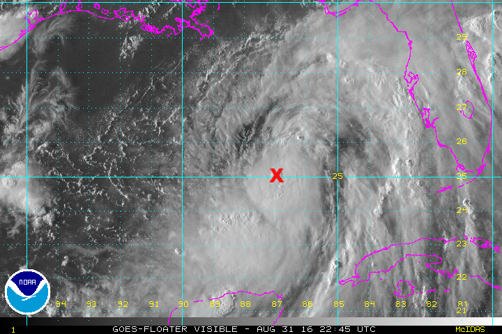
Here is the IR for night time:

http://weather.msfc.nasa.gov/cgi-bin/ge ... olor=black

Watch it like a hawk lol


That is getting to look pretty f***ing ugly.
0 likes   

caneman
Category 5
Category 5
Posts: 1456
Joined: Fri Sep 05, 2014 5:44 am
Location: Clearwater Beach, Fl

Re: ATL: HERMINE - Tropical Storm - Discussion

#6982 Postby caneman » Wed Aug 31, 2016 6:19 pm

I concur. I've been thinking Cedar Key the whole time as well. If this east shift verifies as a trend, it'd be darn nice if they would put St. Pete and Clearwater under watches. The city I live in Largo has had the most rain so far with 10 inches today!!!!! That has to be a record. Any kind of wind and trees are going down.
Last edited by caneman on Wed Aug 31, 2016 6:20 pm, edited 2 times in total.
0 likes   

User avatar
northjaxpro
S2K Supporter
S2K Supporter
Posts: 8900
Joined: Mon Sep 27, 2010 11:21 am
Location: Jacksonville, FL

Re: ATL: HERMINE - Tropical Storm - Discussion

#6983 Postby northjaxpro » Wed Aug 31, 2016 6:20 pm

Well, it looks as if this new convective blowup on imagery near the center really is looking good. This explains why Recon is finding a slowly strengthening cyclone. I am not liking this trend at all. Hermine is perculating folks.
3 likes   
NEVER, EVER SAY NEVER in the tropics and weather in general, and most importantly, with life itself!!

________________________________________________________________________________________

Fay 2008 Beryl 2012 Debby 2012 Colin 2016 Hermine 2016 Julia 2016 Matthew 2016 Irma 2017 Dorian 2019

CrazyC83
Professional-Met
Professional-Met
Posts: 34103
Joined: Tue Mar 07, 2006 11:57 pm
Location: Deep South, for the first time!

Re: ATL: HERMINE - Recon

#6984 Postby CrazyC83 » Wed Aug 31, 2016 6:20 pm

000
URNT15 KWBC 312315
NOAA3 1009A CYCLONE HDOB 45 20160831
230600 2505N 08735W 8407 01549 0025 +201 +152 324008 009 013 000 00
230630 2505N 08733W 8407 01548 0029 +194 +154 326006 006 014 000 00
230700 2506N 08731W 8408 01547 0028 +197 +149 307007 008 013 000 00
230730 2506N 08729W 8407 01548 0028 +196 +146 304006 007 014 000 00
230800 2507N 08727W 8407 01547 0027 +197 +143 325008 008 012 000 00
230830 2507N 08725W 8407 01546 0026 +196 +141 319009 010 012 000 00
230900 2508N 08722W 8408 01545 0028 +193 +146 305009 009 015 000 00
230930 2508N 08720W 8407 01545 0026 +192 +156 299010 012 014 000 00
231000 2509N 08718W 8407 01543 0021 +198 +151 304011 012 013 000 00
231030 2509N 08716W 8407 01542 0020 +196 +160 290010 010 013 000 00
231100 2510N 08714W 8407 01540 0016 +200 +158 282010 011 014 000 00
231130 2511N 08712W 8413 01534 0014 +201 +152 276010 011 013 000 03
231200 2513N 08712W 8407 01540 0013 +205 +142 294007 007 013 000 00
231230 2515N 08711W 8407 01538 0010 +212 +141 309003 005 012 000 03
231300 2516N 08710W 8412 01535 0008 +210 +160 160003 004 011 000 00
231330 2517N 08708W 8415 01535 0011 +208 +161 148005 007 016 000 00
231400 2517N 08706W 8410 01536 0006 +213 +163 154009 010 022 000 00
231430 2517N 08704W 8412 01533 0004 +215 +164 134013 014 035 000 00
231500 2517N 08702W 8407 01539 0004 +215 +155 134014 015 039 000 00
231530 2517N 08700W 8420 01525 0010 +206 +171 126018 019 041 000 00

Pressure 1000mb.
0 likes   

User avatar
SEASON_CANCELED
Category 3
Category 3
Posts: 887
Joined: Mon Jul 06, 2009 5:17 am
Location: 8 Bit Charlie Sheen

Re: ATL: HERMINE - Tropical Storm - Discussion

#6985 Postby SEASON_CANCELED » Wed Aug 31, 2016 6:20 pm

caneman wrote:I concur. I've been thinking Cedar Key the whole time as well. If this east shift verifies as a trend, it'd be darn nice if they would put St. Pete and Clearwater under watches.


Yah at most a direct hit on citrus county..nobody is talking about a direct hit on saint Pete Tampa. I think not extending watches to Sarasota was a midtake
Last edited by SEASON_CANCELED on Wed Aug 31, 2016 6:21 pm, edited 1 time in total.
0 likes   
i am a big stupid ugly moron with an ugly face and a big butt and my butt stinks and i like to kiss my own butt

User avatar
chris_fit
Category 5
Category 5
Posts: 3255
Age: 42
Joined: Wed Sep 10, 2003 11:58 pm
Location: Tampa Bay Area, FL

Re: ATL: HERMINE - Tropical Storm - Discussion

#6986 Postby chris_fit » Wed Aug 31, 2016 6:20 pm

caneman wrote:I concur. I've been thinking Cedar Key the whole time as well. If this east shift verifies as a trend, it'd be darn nice if they would put St. Pete and Clearwater under watches.


I know right, I'd like to know the reasoning.

Warning, OK, fine, maybe no warning.... but not even a watch???? These are the places getting the worst of it right now. Tropical Storm Conditions ARE occurring. right. now. (check the latest band on radar)
1 likes   

Aric Dunn
Category 5
Category 5
Posts: 21238
Age: 43
Joined: Sun Sep 19, 2004 9:58 pm
Location: Ready for the Chase.
Contact:

Re: ATL: HERMINE - Tropical Storm - Discussion

#6987 Postby Aric Dunn » Wed Aug 31, 2016 6:21 pm

pressure down to a 1000mb.. deepening every hours. motion still very slow and erratic.
Last edited by Aric Dunn on Wed Aug 31, 2016 6:22 pm, edited 1 time in total.
3 likes   
Note: If I make a post that is brief. Please refer back to previous posts for the analysis or reasoning. I do not re-write/qoute what my initial post said each time.
If there is nothing before... then just ask :)

Space & Atmospheric Physicist, Embry-Riddle Aeronautical University,
I believe the sky is falling...

OntarioEggplant
Category 1
Category 1
Posts: 312
Joined: Sun Aug 07, 2016 11:16 am

Re: ATL: HERMINE - Tropical Storm - Discussion

#6988 Postby OntarioEggplant » Wed Aug 31, 2016 6:21 pm

Pressure dropping on each pass now. Extrap 1000 MB
1 likes   

benh316

Re: ATL: HERMINE - Tropical Storm - Discussion

#6989 Postby benh316 » Wed Aug 31, 2016 6:23 pm

northjaxpro wrote:Well, it looks as if this new convective blowup on imagery near the center really is looking good. This explains why Recon is finding a slowly strengthening cyclone. I am not liking this trend at all. Hermine is perculating folks.


Couldn't agree more. This is seriously becoming a more and more dangerous situation - and now it's night time. Some folks may end up waking up realizing they are in the middle of a disaster they thought was blowing past them - once again pun is intended.

If this east track continues for 4-6 more hours, I would be seriously concerned.. Let alone the rapidly increasing vorticity

EDIT - to clarify - the east motion still appears to be more wobble in nature. Again, for how long...
Last edited by benh316 on Wed Aug 31, 2016 6:24 pm, edited 1 time in total.
0 likes   

User avatar
artist
Category 5
Category 5
Posts: 9792
Joined: Mon Jun 06, 2005 3:26 pm
Location: West Palm

Re: ATL: HERMINE - Tropical Storm - Discussion

#6990 Postby artist » Wed Aug 31, 2016 6:23 pm

Image

The east one was the latest 1002
chris_fit wrote:
JaxGator wrote:


More storms are popping on that loop. The strengthening trend is ominous.


So is that eastward push an illusion or really happening? I cant even tell with recon lol
0 likes   

stormreader

Re: ATL: HERMINE - Tropical Storm - Discussion

#6991 Postby stormreader » Wed Aug 31, 2016 6:24 pm

[img]http://www.ssd.noaa.gov/goes/east/eaus/wv-animated.gif[img]
WV imagery showing elongated Hermine (SW-NE) in response to "suction" provided by trough over E US. Storm energy already streaming up along the Eastern Seaboard. However, Hermine (the storm itself) remains relatively stubborn with not much movement over last 24 hours. Still waiting for truly decisive N to NE move by the storm.
0 likes   

BRweather
Category 1
Category 1
Posts: 331
Joined: Wed Aug 31, 2016 8:50 am
Location: Baton Rouge, LA

Re: ATL: HERMINE - Tropical Storm - Discussion

#6992 Postby BRweather » Wed Aug 31, 2016 6:24 pm

Hopefully Air Force will have a little better flight path. :lol:

Getting difficult to make out each path
1 likes   

User avatar
sponger
S2K Supporter
S2K Supporter
Posts: 1623
Joined: Thu Jul 22, 2004 11:26 am
Location: St Augustine

Re: ATL: HERMINE - Tropical Storm - Discussion

#6993 Postby sponger » Wed Aug 31, 2016 6:25 pm

chris_fit wrote:
JaxGator wrote:


More storms are popping on that loop. The strengthening trend is ominous.


So is that eastward push an illusion or really happening? I cant even tell with recon lol


We have been fooled before but recon and visual confirms East! Lets see how long it lasts! Remember Charley? A wobble turned out to be a hook and we did not recognize it for 2 hours. Remember Jeanne, model garbage in garbage out. We did not have the NOAA flights critical for model input so anything is possible, but this is not a wobble. This is movement!
Last edited by sponger on Wed Aug 31, 2016 6:27 pm, edited 1 time in total.
1 likes   
The following post is NOT an official forecast and should not be used as such. It is just the opinion of the poster and may or may not be backed by sound meteorological data. It is NOT endorsed by any professional institution including storm2k.org For Official Information please refer to the NHC and NWS products.

FLLurker32
Tropical Storm
Tropical Storm
Posts: 245
Joined: Mon Aug 29, 2016 10:31 am

Re: ATL: HERMINE - Tropical Storm - Discussion

#6994 Postby FLLurker32 » Wed Aug 31, 2016 6:26 pm

To the naked eye on radar it does look like it's going NE already BUT I know with the shifting of convection that can be deceiving. I'm interested to know what the AF finds.
0 likes   
Heather

User avatar
NDG
S2K Supporter
S2K Supporter
Posts: 15473
Joined: Sun Jul 09, 2006 10:14 pm
Location: Orlando, FL

Re: ATL: HERMINE - Tropical Storm - Discussion

#6995 Postby NDG » Wed Aug 31, 2016 6:26 pm

Where they have been finding the lowest pressure, for those that are wondering, right by the deep convection.

Image
2 likes   

stormreader

Re: ATL: HERMINE - Tropical Storm - Discussion

#6996 Postby stormreader » Wed Aug 31, 2016 6:27 pm

stormreader wrote:[img]http://www.ssd.noaa.gov/goes/east/eaus/wv-animated.gif[img]
WV imagery showing elongated Hermine (SW-NE) in response to "suction" provided by trough over E US. Storm energy already streaming up along the Eastern Seaboard. However, Hermine (the storm itself) remains relatively stubborn with not much movement over last 24 hours. Still waiting for truly decisive N to NE move by the storm.
Sorry! Forgot how to post actual images to the board.
0 likes   

tallywx
Category 2
Category 2
Posts: 790
Joined: Thu Jul 03, 2003 10:19 am
Location: Raleigh/Durham, NC

Re: ATL: HERMINE - Tropical Storm - Discussion

#6997 Postby tallywx » Wed Aug 31, 2016 6:29 pm

sponger wrote:
chris_fit wrote:
JaxGator wrote:
More storms are popping on that loop. The strengthening trend is ominous.


So is that eastward push an illusion or really happening? I cant even tell with recon lol


We have been fooled before but recon and visual confirms East! Lets see how long it lasts! Remember Charley? A wobble turned out to be a hook and we did not recognize it for 2 hours. Remember Jeanne, model garbage in garbage out. We did not have the NOAA flights critical for model input so anything is possible, but this is not a wobble. This is movement!


Latest aircraft pressure and wind center was north of previous fix (wind center at 2516N 08710W, pressure center at 2517N 08702W). Last pass was at 2457N 08659W. Still wobbling about, but if anything the latest wobble was due N or NNNNW.
Last edited by tallywx on Wed Aug 31, 2016 6:30 pm, edited 1 time in total.
0 likes   

cdavis6287
Tropical Depression
Tropical Depression
Posts: 61
Joined: Mon Aug 22, 2016 11:37 pm

Re: ATL: HERMINE - Tropical Storm - Discussion

#6998 Postby cdavis6287 » Wed Aug 31, 2016 6:29 pm

rickybobby wrote:On and off rain in port orange for most of the day. No wind.

Small world. I live in palm coast. Used to live in the shores and work in Ormond.
0 likes   

psyclone
S2K Supporter
S2K Supporter
Posts: 4779
Joined: Wed Aug 24, 2005 9:04 pm
Location: palm harbor fl

Re: ATL: HERMINE - Tropical Storm - Discussion

#6999 Postby psyclone » Wed Aug 31, 2016 6:29 pm

I wouldn't be surprised to see the track tilt back east a touch. time will tell. It sure looks like the forgotten coast over to the big bend is in line for the worst with that lopsided windfield. I'd really be concerned up there. Franklin county is doing mandatory evacuations and that seems warranted based on how vulnerable that coastline is to surge. Speaking of surge I just love the new storm surge product from the NHC. It is just superb. Bravo to the folks at the NHC that worked on that. I can envision that product resulting in lifesaving decisions during a big event. Too bad it wasn't around for Katrina.
2 likes   

Aric Dunn
Category 5
Category 5
Posts: 21238
Age: 43
Joined: Sun Sep 19, 2004 9:58 pm
Location: Ready for the Chase.
Contact:

Re: ATL: HERMINE - Tropical Storm - Discussion

#7000 Postby Aric Dunn » Wed Aug 31, 2016 6:29 pm

tallywx wrote:
sponger wrote:
chris_fit wrote:
So is that eastward push an illusion or really happening? I cant even tell with recon lol


We have been fooled before but recon and visual confirms East! Lets see how long it lasts! Remember Charley? A wobble turned out to be a hook and we did not recognize it for 2 hours. Remember Jeanne, model garbage in garbage out. We did not have the NOAA flights critical for model input so anything is possible, but this is not a wobble. This is movement!


Latest aircraft pressure and wind center was north of previous fix. Still wobbling about.

yeah very erratic at the moment. models are slowly bringing it ashore later and later into friday.
0 likes   
Note: If I make a post that is brief. Please refer back to previous posts for the analysis or reasoning. I do not re-write/qoute what my initial post said each time.
If there is nothing before... then just ask :)

Space & Atmospheric Physicist, Embry-Riddle Aeronautical University,
I believe the sky is falling...


Return to “2016”

Who is online

Users browsing this forum: No registered users and 48 guests