GCANE wrote:That buoy just SE of the CoC is really taking a dive.
ATL: HERMINE - Post-Tropical - Discussion
Moderator: S2k Moderators
-
terrapintransit

- Category 1

- Posts: 275
- Age: 51
- Joined: Tue Sep 04, 2007 8:08 pm
- Location: Williamsport, Pa
Re: ATL: HERMINE - Tropical Storm - Discussion
What does this suggest??
0 likes
Aaron
-
drewschmaltz
- S2K Supporter

- Posts: 351
- Joined: Thu Aug 27, 2015 8:19 pm
Re: ATL: HERMINE - Tropical Storm - Discussion
terrapintransit wrote:What does this suggest??
Well, that converts to a surface pressure of 1000 mb for reference.
Last edited by drewschmaltz on Thu Sep 01, 2016 6:01 am, edited 1 time in total.
1 likes
I HAVE ABSOLUTELY NO IDEA WHAT I'M TALKING ABOUT. PLEASE CONSULT SOMEONE WHO DOES. START WITH THE NHC. ALL POSTS ARE FOR ENTERTAINMENT PURPOSES ONLY.

Re: ATL: HERMINE - Tropical Storm - Discussion
terrapintransit wrote:What does this suggest??GCANE wrote:That buoy just SE of the CoC is really taking a dive.
Intensification
1 likes
-
Extratropical94

- Professional-Met

- Posts: 3545
- Age: 31
- Joined: Wed Oct 20, 2010 6:36 am
- Location: Hamburg, Germany
- Contact:
Re: ATL: HERMINE - Tropical Storm - Discussion
GCANE wrote:That buoy just SE of the CoC is really taking a dive.
http://www.ndbc.noaa.gov/plot_met.php?s ... _label=CDT
Most impressive thing IMO is that Hermine is actually moving away from that buoy but the pressure keeps dropping.
0 likes
54° 11' 59'' N, 9° 9' 20'' E
Boomer Sooner!
Go Broncos! Go Cards!
Clinching counties, one at a time: https://mob-rule.com/user-gifs/USA/xtrp94.gif
- Daniel
Boomer Sooner!
Go Broncos! Go Cards!
Clinching counties, one at a time: https://mob-rule.com/user-gifs/USA/xtrp94.gif
- Daniel

Re: ATL: HERMINE - Tropical Storm - Discussion
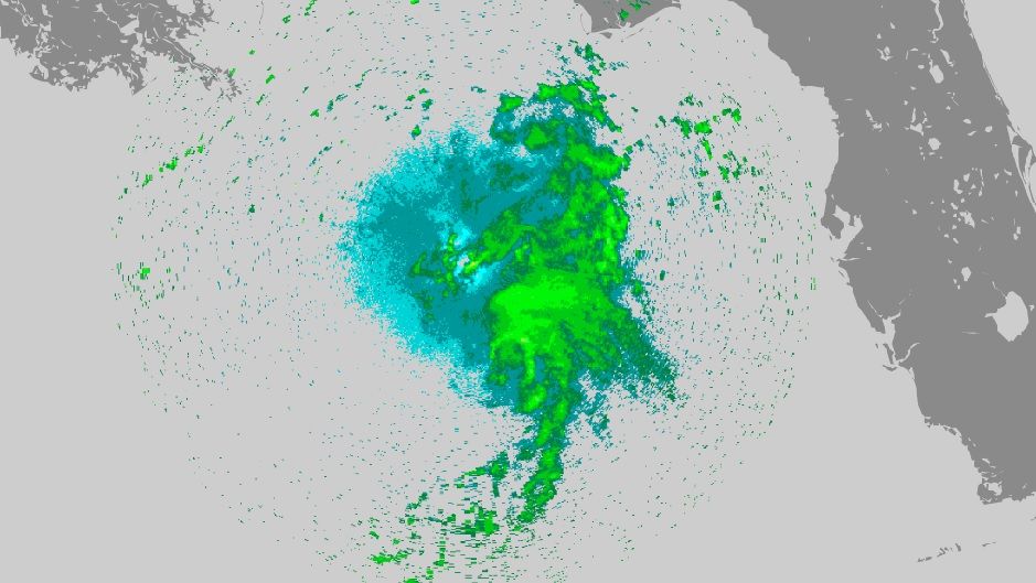
Nice radar shot from the NOAA recon, nice banding developing around the coc.
1 likes

Re: ATL: HERMINE - Tropical Storm - Discussion
Really starting to spin up now so we will have to watch the windfields.
The outflow north of the system is expanding north and west without as much restriction so I'm expecting a more symmetric storm at landfall.
Currently most of the convection is pushed off to the east of the center but the center track has been solid NNE.
Models are all in close agreement about the landfall of those strong core winds being closer to St George island than Cedar key although St George island gets the weak side of the storm.
Wind field from a 969 mb Hurricane could still bring tropical storm force winds as far east as the Pinellas beaches though.
0 likes

Re: ATL: HERMINE - Tropical Storm - Discussion
NDG wrote:So based on the recon fixes during the past 4 hours, Hermine is almost moving on a NE heading, based on the calculations below with an average speed of 12.5 mph.Code: Select all
Point 1:
25 56 00N
 ,
087 04 00W
Point 2:
26 40 00N
 ,
086 20 00W
Distance:   109.5 km (to 4 SF*)
Initial bearing:   041°42′50″
Final bearing:   042°02′20″
Yeah quite worrisome..its been moving nearly due NE now. if it continued, landfall further east between Taylor County and cedar key.
1 likes
Re: ATL: HERMINE - Tropical Storm - Discussion
Nimbus wrote:Really starting to spin up now so we will have to watch the windfields.
The outflow north of the system is expanding north and west without as much restriction so I'm expecting a more symmetric storm at landfall.
Currently most of the convection is pushed off to the east of the center but the center track has been solid NNE.
Models are all in close agreement about the landfall of those strong core winds being closer to St George island than Cedar key although St George island gets the weak side of the storm.
Wind field from a 969 mb Hurricane could still bring tropical storm force winds as far east as the Pinellas beaches though.
Not entirely true. Did you,see what Ndg posted? Northeast for last 4 hours. That could mean Cedar Key or a bit north is in play.
0 likes
Re: ATL: HERMINE - Tropical Storm - Discussion
Nimbus wrote:Really starting to spin up now so we will have to watch the windfields.
The outflow north of the system is expanding north and west without as much restriction so I'm expecting a more symmetric storm at landfall.
Currently most of the convection is pushed off to the east of the center but the center track has been solid NNE.
Models are all in close agreement about the landfall of those strong core winds being closer to St George island than Cedar key although St George island gets the weak side of the storm.
Wind field from a 969 mb Hurricane could still bring tropical storm force winds as far east as the Pinellas beaches though.
No question that Pinellas county will see TS force winds even if it stays at this same strength, as recon has found those winds more than 100 miles east of the coc.
1 likes
Re: ATL: HERMINE - Tropical Storm - Discussion
Extratropical94 wrote:GCANE wrote:That buoy just SE of the CoC is really taking a dive.
http://www.ndbc.noaa.gov/plot_met.php?s ... _label=CDT
Most impressive thing IMO is that Hermine is actually moving away from that buoy but the pressure keeps dropping.
Exactly.
I know RI is subjective, but one criteria, if I remember correctly, is a drop of 25 mb in 24 hrs or roughly 1 mb per hr.
Someone please correct me if I am wrong.
0 likes
Re: ATL: HERMINE - Tropical Storm - Discussion
Will NHC go ahead and extend watches down through Pinellas and if so when? Anyone have thoughts?
0 likes
Re: ATL: HERMINE - Tropical Storm - Discussion
GCANE wrote:Extratropical94 wrote:GCANE wrote:That buoy just SE of the CoC is really taking a dive.
http://www.ndbc.noaa.gov/plot_met.php?s ... _label=CDT
Most impressive thing IMO is that Hermine is actually moving away from that buoy but the pressure keeps dropping.
Exactly.
I know RI is subjective, but one criteria, if I remember correctly, is a drop of 25 mb in 24 hrs or roughly 1 mb per hr.
Someone please correct me if I am wrong.
It is 42 mb for 24 hours, not 25. 1.75mb per hour
2 likes
Re: ATL: HERMINE - Tropical Storm - Discussion
caneman wrote:Well, if that holds true and continues thay way and my math is correct that would put it just over 100 miles off my coast line. Is NHC going to go ahead and play chicken?
Caneman..if this heading holds and the storm continues to expand and strengthen, I think the NHC would have no choice but to extend the TS warnings to cover Tampa Bay area.
0 likes
Re: ATL: HERMINE - Tropical Storm - Discussion
caneman wrote:Will NHC go ahead and extend watches down through Pinellas and if so when? Anyone have thoughts?
If the current heading continues I wouldn't doubt if they extend hurricane watch and or warnings down to Pinellas County as they could see close to hurricane force winds in gusts, IMO.
1 likes
-
txwatcher91
- Category 5

- Posts: 1498
- Joined: Tue Aug 02, 2005 2:29 pm
Re: ATL: HERMINE - Tropical Storm - Discussion
Now down to 993mb on most recent pass by recon and center moved N or slightly NNW from previous fix. Looks like it is either wobbling this direction or maybe starting a new movement (some models turn it due N today).
0 likes
-
OntarioEggplant
- Category 1
- Posts: 312
- Joined: Sun Aug 07, 2016 11:16 am
Re: ATL: HERMINE - Tropical Storm - Discussion
It's amazing how every phase through the center has it down 1 mb
0 likes
Re: ATL: HERMINE - Tropical Storm - Discussion
Based on the latest fix it looks like Hermine did a jog to the north, so maybe back to a NNE heading over the next few hours.
1 likes
Re: ATL: HERMINE - Tropical Storm - Discussion
ronjon wrote:caneman wrote:Well, if that holds true and continues thay way and my math is correct that would put it just over 100 miles off my coast line. Is NHC going to go ahead and play chicken?
Caneman..if this heading holds and the storm continues to expand and strengthen, I think the NHC would have no choice but to extend the TS warnings to cover Tampa Bay area.
My frustration is that they can be slow to react. Based on my logic and a few others yesterday, pinellas should have been included yesterday. If you got t.s. winds at Anclote, you're most certainly going to have them on pinellas beaches since they protrude out west. I mean if NWS is saying expect mid 40's gusts... Oh well. Let's see what happens.
Last edited by caneman on Thu Sep 01, 2016 6:23 am, edited 2 times in total.
0 likes
Re: ATL: HERMINE - Tropical Storm - Discussion
outflow expanding to the NW quad. This should be a hurricane in a few hours
2 likes
Re: ATL: HERMINE - Tropical Storm - Discussion
txwatcher91 wrote:Now down to 993mb on most recent pass by recon and center moved N or slightly NNW from previous fix. Looks like it is either wobbling this direction or maybe starting a new movement (some models turn it due N today).
LOL...wobble watching has commenced!
2 likes
Who is online
Users browsing this forum: No registered users and 8 guests