wv loop, looks like it's building outflow on the north now.
http://weather.msfc.nasa.gov/cgi-bin/get-goes?satellite=GOES-E%20CONUS&lat=25&lon=-85&info=wv&zoom=4&width=1400&height=800&quality=90&type=Animation&palette=wv2.pal&numframes=30&mapcolor=black
ATL: HERMINE - Post-Tropical - Discussion
Moderator: S2k Moderators
-
tolakram
- Admin

- Posts: 20186
- Age: 62
- Joined: Sun Aug 27, 2006 8:23 pm
- Location: Florence, KY (name is Mark)
Re: ATL: HERMINE - Tropical Storm - Discussion
1 likes
M a r k
- - - - -
Join us in chat: Storm2K Chatroom Invite. Android and IOS apps also available.
The posts in this forum are NOT official forecasts and should not be used as such. Posts are NOT endorsed by any professional institution or STORM2K.org. For official information and forecasts, please refer to NHC and NWS products.
-
marionstorm
- Tropical Depression

- Posts: 94
- Joined: Wed Aug 31, 2016 4:46 am
Re: ATL: HERMINE - Tropical Storm - Discussion
When will the next plane be in to give us a Vortex message?
0 likes

Re: ATL: HERMINE - Tropical Storm - Discussion
OuterBanker wrote:When I went to bed last night it was forecast up the middle of the state. Now it's back to along the coast. In fact latest models have it right over the outer banks.
But, I'm not worried. Wxman several days ago said that it wasn't going to be a Carolina problem
Make sure to tell the Ocracoke Cedar Island ferry captain that tomorrow.
Lite squalls over the sound this morning. The outer banks sure need rain.
Last edited by syfr on Thu Sep 01, 2016 7:31 am, edited 2 times in total.
0 likes
I'm not a meteorologist, I'm an electronics engineer. While I can probably fix your toaster oven, you're not going to learn about storms from me!
New Mexico had no hurricanes. Then I moved to NC right before Fran.....
New Mexico had no hurricanes. Then I moved to NC right before Fran.....
-
northjaxpro

- S2K Supporter

- Posts: 8900
- Joined: Mon Sep 27, 2010 11:21 am
- Location: Jacksonville, FL
Re: ATL: HERMINE - Tropical Storm - Discussion
txwatcher91 wrote:I guess we can put to rest the theory now that models are wrong and this is likely to make landfall along or south of Tampa...
On a serious note residents need to make sure they are prepared for this storm. A hurricane at landfall looks increasingly likely and it could possibly be stronger than currently forecast also. A high cat 1 or low 2 that is strengthening at landfall can be pretty bad.
That is the huge concern right now.
0 likes
NEVER, EVER SAY NEVER in the tropics and weather in general, and most importantly, with life itself!!
________________________________________________________________________________________
Fay 2008 Beryl 2012 Debby 2012 Colin 2016 Hermine 2016 Julia 2016 Matthew 2016 Irma 2017 Dorian 2019
________________________________________________________________________________________
Fay 2008 Beryl 2012 Debby 2012 Colin 2016 Hermine 2016 Julia 2016 Matthew 2016 Irma 2017 Dorian 2019
-
tolakram
- Admin
- Posts: 20186
- Age: 62
- Joined: Sun Aug 27, 2006 8:23 pm
- Location: Florence, KY (name is Mark)
Re: ATL: HERMINE - Tropical Storm - Discussion
marionstorm wrote:When will the next plane be in to give us a Vortex message?
Flight two is scheduled for 13:30Z which is one hour from now.
1 likes
M a r k
- - - - -
Join us in chat: Storm2K Chatroom Invite. Android and IOS apps also available.
The posts in this forum are NOT official forecasts and should not be used as such. Posts are NOT endorsed by any professional institution or STORM2K.org. For official information and forecasts, please refer to NHC and NWS products.
- - - - -
Join us in chat: Storm2K Chatroom Invite. Android and IOS apps also available.
The posts in this forum are NOT official forecasts and should not be used as such. Posts are NOT endorsed by any professional institution or STORM2K.org. For official information and forecasts, please refer to NHC and NWS products.
-
Hurricane Andrew

- S2K Supporter
- Posts: 1891
- Age: 27
- Joined: Sun May 23, 2010 2:53 pm
- Location: KS
Re: ATL: HERMINE - Tropical Storm - Discussion
It definitely looks like it will continue to intensify until landfall, convection is beginning to swing around north of the center. Could make a run for a strong cat 1 or weak 2...surge may be higher than expected.
0 likes
The Enthusiast
NREMT-AEMT, WX nerd
Irene '11, Sandy '12, Irma '17 (SAR)
"Hard to think we were born to live this way..." -Wage War
-
deltadog03

- Professional-Met

- Posts: 3580
- Joined: Tue Jul 05, 2005 6:16 pm
- Location: Macon, GA
Re: ATL: HERMINE - Tropical Storm - Discussion
tolakram wrote:wv loop, looks like it's building outflow on the north now.
http://weather.msfc.nasa.gov/cgi-bin/get-goes?satellite=GOES-E%20CONUS&lat=25&lon=-85&info=wv&zoom=4&width=1400&height=800&quality=90&type=Animation&palette=wv2.pal&numframes=30&mapcolor=black
Great post. Also tells me where she is heading. Prob gonna get tugged in a general Northerly direction.
0 likes
-
txwatcher91
- Category 5

- Posts: 1498
- Joined: Tue Aug 02, 2005 2:29 pm
Re: ATL: HERMINE - Tropical Storm - Discussion
My concern for FL residents is this, most have prepared for a tropical storm or low cat 1 hurricane. Hermine is now taking on a classic "fist" shape on satellite, shear continues to decrease, outflow is expanding and it's becoming more symmetrical. These all point to continued steady to quick strengthening today and up to landfall. A cat 2 is very possible imo and many would not have time to prepare and/or evacuate if necessary.
0 likes
-
txwatcher91
- Category 5
- Posts: 1498
- Joined: Tue Aug 02, 2005 2:29 pm
Re: ATL: HERMINE - Tropical Storm - Discussion
caneman wrote:txwatcher91 wrote:I guess we can put to rest the theory now that models are wrong and this is likely to make landfall along or south of Tampa...
On a serious note residents need to make sure they are prepared for this storm. A hurricane at landfall looks increasingly likely and it could possibly be stronger than currently forecast also. A high cat 1 or low 2 that is strengthening at landfall can be pretty bad.
I'm pretty sure only 1 person ever said that and they stopped posting. So, really kind of irrelevant.
It's important to note since some new posters were doubting or questioning the NHC. I bring it up because the NHC is great at what they do and while not perfect their expertise combined with use of all the tools they have available makes them the go to source for these scenarios.
3 likes
Re: ATL: HERMINE - Tropical Storm - Discussion
deltadog03 wrote:tolakram wrote:wv loop, looks like it's building outflow on the north now.
http://weather.msfc.nasa.gov/cgi-bin/get-goes?satellite=GOES-E%20CONUS&lat=25&lon=-85&info=wv&zoom=4&width=1400&height=800&quality=90&type=Animation&palette=wv2.pal&numframes=30&mapcolor=black
Great post. Also tells me where she is heading. Prob gonna get tugged in a general Northerly direction.
I may owe someone a steak dinner. Cedar Key looks,out now and Appalachacola looks about right. Although yesterday the said a N.E. turn and today the say NNE through landfall.
Last edited by caneman on Thu Sep 01, 2016 7:41 am, edited 1 time in total.
1 likes
-
terrapintransit

- Category 1

- Posts: 275
- Age: 51
- Joined: Tue Sep 04, 2007 8:08 pm
- Location: Williamsport, Pa
Re: ATL: HERMINE - Tropical Storm - Discussion
Feeding off that hot water..
txwatcher91 wrote:My concern for FL residents is this, most have prepared for a tropical storm or low cat 1 hurricane. Hermine is now taking on a classic "fist" shape on satellite, shear continues to decrease, outflow is expanding and it's becoming more symmetrical. These all point to continued steady to quick strengthening today and up to landfall. A cat 2 is very possible imo and many would not have time to prepare and/or evacuate if necessary.
0 likes
Aaron
Re: ATL: HERMINE - Tropical Storm - Discussion
txwatcher91 wrote:caneman wrote:txwatcher91 wrote:I guess we can put to rest the theory now that models are wrong and this is likely to make landfall along or south of Tampa...
On a serious note residents need to make sure they are prepared for this storm. A hurricane at landfall looks increasingly likely and it could possibly be stronger than currently forecast also. A high cat 1 or low 2 that is strengthening at landfall can be pretty bad.
I'm pretty sure only 1 person ever said that and they stopped posting. So, really kind of irrelevant.
It's important to note since some new posters were doubting or questioning the NHC. I bring it up because the NHC is great at what they do and while not perfect their expertise combined with use of all the tools they have available makes them the go to source for these scenarios.
I'm pretty sure everyone is aware of the newbie people I disagree with but to each his own.
2 likes

Re: ATL: HERMINE - Tropical Storm - Discussion
txwatcher91 wrote:My concern for FL residents is this, most have prepared for a tropical storm or low cat 1 hurricane. Hermine is now taking on a classic "fist" shape on satellite, shear continues to decrease, outflow is expanding and it's becoming more symmetrical. These all point to continued steady to quick strengthening today and up to landfall. A cat 2 is very possible imo and many would not have time to prepare and/or evacuate if necessary.
This is where the benefits of the new storm surge guidance comes into play. It's already accounting for a storm being a bit stronger than forecast. Hopefully the people making calls have been using it properly.
2 likes
-
tolakram
- Admin
- Posts: 20186
- Age: 62
- Joined: Sun Aug 27, 2006 8:23 pm
- Location: Florence, KY (name is Mark)
Re: ATL: HERMINE - Recon Discussion
Looks like next flight starts at 9:30 EDT, 13:30Z. Did I get that right? I always screw up reading the recon flight times.
I. ATLANTIC REQUIREMENTS
1. TROPICAL DEPRESSION NINE (GULF OF MEXICO)
FLIGHT ONE - TEAL 71 FLIGHT TWO - TEAL 72
A. 01/0000Z A. 01/1430Z,1730Z,2030Z
B. AFXXX 1109A CYCLONE B. AFXXX 1309A CYCLONE
C. 31/2245Z C. 01/1330Z
D. 26.ON 87.4W D. 27.7N 86.0W
E. 31/2330Z TO 01/0130Z E. 01/1400Z TO 01/2030Z
F. SFC TO 10,000 FT F. SFC TO 10,000 FT
FLIGHT THREE - TEAL 71 FLIGHT FOUR -TEAL 72
A. 01/2330Z,02/0230Z,0530Z A. 02/0830Z,1130Z,1430Z
B. AFXXX 1409A CYCLONE B. AFXXX 1509A CYCLONE
C. 01/2230Z C. 02/0730Z
D. 29.0N 85.0W D. 30.2N 83.2W
E. 01/2300Z TO 02/0530Z E. 02/0800Z TO 02/1430Z
F. SFC TO 10,000 FT F. SFC TO 10,000 FT
2. SUCCEEDING DAY OUTLOOK: CONTINUE 3-HRLY FIXES WHILE
SYSTEM REMAINS A THREAT.
3. REMARKS: FLIGHT ONE ABOVE IS A RESOURCES PERMITTING
FIGHT WHICH WAS ADDED.
0 likes
M a r k
- - - - -
Join us in chat: Storm2K Chatroom Invite. Android and IOS apps also available.
The posts in this forum are NOT official forecasts and should not be used as such. Posts are NOT endorsed by any professional institution or STORM2K.org. For official information and forecasts, please refer to NHC and NWS products.
- - - - -
Join us in chat: Storm2K Chatroom Invite. Android and IOS apps also available.
The posts in this forum are NOT official forecasts and should not be used as such. Posts are NOT endorsed by any professional institution or STORM2K.org. For official information and forecasts, please refer to NHC and NWS products.
-
thundercam96

- Tropical Storm

- Posts: 129
- Joined: Thu Aug 18, 2011 3:01 pm
- Location: Boston, MA
Re: ATL: HERMINE - Tropical Storm - Discussion
northjaxpro wrote:thundercam96 wrote:I feel like Daytona Beach is in the clear...
I would be very mindful .to not make such a declaration. Although Volusia County may not be under watches or warnings at this time, but that still does not guarantee that you get some impacts. Remember, this is a large storm and the tropical storm wind field will be only expand across the area. Also, as.the squalls move through the region after landfall during the next 24 hours, there is still the possity of tornadoes which can spin up without warnings. Yes, even in the areas just outside the watch or warning areas.
The reason I made that statement, is because it seems as if we will miss the main effects of it. Forecasting 20 mph winds, and the local colleges are still planning for class tomorrow. Business as usual unfortunately.
1 likes
Fay '08 / Mathew 16'
Personal Forecast Disclaimer: I am not a certified meteorologist, therefore, what is posted on this forum under my header should not be treated as an official forecast. Please refer to the NWS/NHC products for forecast information.
Personal Forecast Disclaimer: I am not a certified meteorologist, therefore, what is posted on this forum under my header should not be treated as an official forecast. Please refer to the NWS/NHC products for forecast information.
-
deltadog03
- Professional-Met
- Posts: 3580
- Joined: Tue Jul 05, 2005 6:16 pm
- Location: Macon, GA
Re: ATL: HERMINE - Tropical Storm - Discussion
caneman wrote:deltadog03 wrote:tolakram wrote:wv loop, looks like it's building outflow on the north now.
http://weather.msfc.nasa.gov/cgi-bin/get-goes?satellite=GOES-E%20CONUS&lat=25&lon=-85&info=wv&zoom=4&width=1400&height=800&quality=90&type=Animation&palette=wv2.pal&numframes=30&mapcolor=black
Great post. Also tells me where she is heading. Prob gonna get tugged in a general Northerly direction.
I may owe someone a steak dinner. Cedar Key looks,out now and Appalachacola looks about right.
Nah.
0 likes
-
Dean4Storms
- S2K Supporter
- Posts: 6358
- Age: 63
- Joined: Sun Aug 31, 2003 1:01 pm
- Location: Miramar Bch. FL
Re: ATL: HERMINE - Tropical Storm - Discussion
Still not much convection on the western flank and you'll need convection to transport some of the higher winds to the surface there so I'm feeling much better here just West of PCB.
Looks like the highest winds will be directly North, NE, East and SE wherever the Center eventually crosses the Coast, you won't have to travel too far West to just have some weak Gales.
Looks like the highest winds will be directly North, NE, East and SE wherever the Center eventually crosses the Coast, you won't have to travel too far West to just have some weak Gales.
0 likes

Re: ATL: HERMINE - Tropical Storm - Discussion
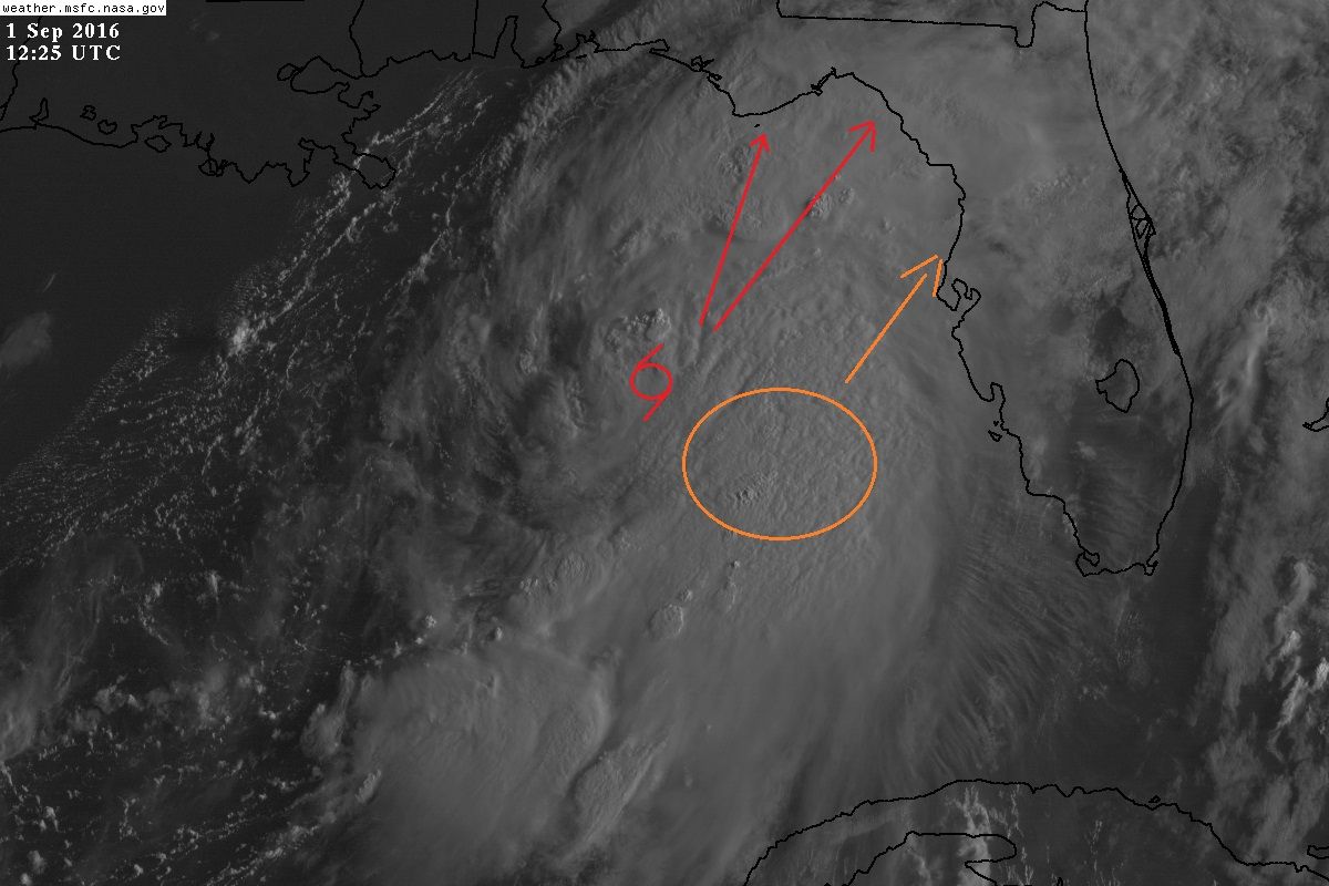
Don't let the quiet wx over Tampa Bay area fool you, I have been seeing a lot of people even on TV thinking that the worst is gone. As Hermine tracks NNE the worst wx is yet to come as sampled the recon earlier this morning the area circled in orange where plenty of tropical force winds were found.
2 likes
-
SunnyThoughts
- Category 5
- Posts: 2263
- Joined: Wed Jul 09, 2003 12:42 pm
- Location: Pensacola, Florida
Re: ATL: HERMINE - Tropical Storm - Discussion
For those in the path who have never experienced a cat 1 hurricane strengthening as it makes landfall, let me tell you...it is NOT a walk in the park. Especially if the area hasn't been hit in a long time and you have numerous trees in the vicinity. In 1995...we stayed home and rode out Hurricane Erin here just to the East of Pensacola. WAs a cat 1 and strengthened to about 100mph just as she came onshore. We had 15 or more trees down on our property..and brush up to our knees ( limbs, leaves just piled up as far as you could see) The worst thing...we were without power for 10 days because it took that long to clear the downed trees for the power trucks to even get in and start to repair the lines and poles. You guys in the path be safe.
1 likes
-
northjaxpro
- S2K Supporter
- Posts: 8900
- Joined: Mon Sep 27, 2010 11:21 am
- Location: Jacksonville, FL
Re: ATL: HERMINE - Tropical Storm - Discussion
txwatcher91 wrote:My concern for FL residents is this, most have prepared for a tropical storm or low cat 1 hurricane. Hermine is now taking on a classic "fist" shape on satellite, shear continues to decrease, outflow is expanding and it's becoming more symmetrical. These all point to continued steady to quick strengthening today and up to landfall. A cat 2 is very possible imo and many would not have time to prepare and/or evacuate if necessary.
Exactly. Great post. I am really concerned for those in the hurricane warning area.in the Big Bend region. Hope they prepared for the worse. We say that all the time, but it is so important to plan for worst case scenarios. Hermine is intensifying at a decent rate this morning and it sure looks like the cyclone may end up.being stronger than the NHC had indicated the last couple of days.
But we had models earlier showing this potential for.a rathet strong hurricane in Apalachee Bay. So it is possible to see Hermine ramp into close to a Cat 2 storm. I hope Hermine is running out of time for this before landfalll
1 likes
NEVER, EVER SAY NEVER in the tropics and weather in general, and most importantly, with life itself!!
________________________________________________________________________________________
Fay 2008 Beryl 2012 Debby 2012 Colin 2016 Hermine 2016 Julia 2016 Matthew 2016 Irma 2017 Dorian 2019
________________________________________________________________________________________
Fay 2008 Beryl 2012 Debby 2012 Colin 2016 Hermine 2016 Julia 2016 Matthew 2016 Irma 2017 Dorian 2019
Who is online
Users browsing this forum: No registered users and 34 guests