000
UZNT13 KWBC 012227
XXAA 51227 99288 70851 08185 99986 27415 06509 00627 ///// /////
92564 23608 05016 85303 21023 05511 70971 14856 03002 88999 77999
31313 09608 82208
61616 NOAA3 WXWXA HERMINE OB 13
62626 CENTER MBL WND 05014 AEV 33236 DLM WND 05010 985696 WL150 0
5512 080 REL 2877N08513W 220819 SPG 2877N08514W 221243 =
XXBB 51228 99288 70851 08185 00986 27415 11850 21023 22827 20241
33764 17017 44696 14656
21212 00986 06509 11964 05015 22921 05018 33912 05013 44850 05511
55696 08002
31313 09608 82208
61616 NOAA3 WXWXA HERMINE OB 13
62626 CENTER MBL WND 05014 AEV 33236 DLM WND 05010 985696 WL150 0
5512 080 REL 2877N08513W 220819 SPG 2877N08514W 221243 =
ATL: HERMINE - Post-Tropical - Discussion
Moderator: S2k Moderators
-
HenkL
- S2K Supporter

- Posts: 2401
- Joined: Fri Sep 10, 2004 5:33 pm
- Location: Groningen, The Netherlands
- Contact:
Re: ATL: HERMINE - Recon
0 likes
-
HenkL
- S2K Supporter
- Posts: 2401
- Joined: Fri Sep 10, 2004 5:33 pm
- Location: Groningen, The Netherlands
- Contact:
Re: ATL: HERMINE - Recon
000
URNT12 KWBC 012232
VORTEX DATA MESSAGE AL092016
A. 01/22:08:28Z
B. 28 deg 45 min N
085 deg 08 min W
C. 700 mb 2982 m
D. 57 kt
E. 079 deg 26 nm
F. 173 deg 60 kt
G. 074 deg 65 nm
H. 986 mb
I. 15 C / 3061 m
J. 15 C / 3060 m
K. 8 C / NA
L. OPEN EAST
M. C25
N. 12345 / 7
O. .01 / 2 nm
P. NOAA3 WXWXA HERMINE OB 14
MAX FL WIND 69 KT 179 / 40 NM 20:48:39Z
MAX FL TEMP 16 C 078 / 26 NM FROM FL CNTR
CNTR DROPSONDE SFC WIND 065 / 09 KTS
0 likes
-
tolakram
- Admin

- Posts: 20186
- Age: 62
- Joined: Sun Aug 27, 2006 8:23 pm
- Location: Florence, KY (name is Mark)
Re: ATL: HERMINE - Recon

0 likes
M a r k
- - - - -
Join us in chat: Storm2K Chatroom Invite. Android and IOS apps also available.
The posts in this forum are NOT official forecasts and should not be used as such. Posts are NOT endorsed by any professional institution or STORM2K.org. For official information and forecasts, please refer to NHC and NWS products.
Re: ATL: HERMINE - Hurricane - Discussion
Nimbus wrote:tallywx wrote:Hurricaneman wrote:
Maybe even slightly east of there
The posts in this forum are NOT official forecast and should not be used as such. They are just the opinion of the poster and may or may not be backed by sound meteorological data. They are NOT endorsed by any professional institution or STORM2K. For official information, please refer to products from the National Hurricane Center and National Weather Service.
According to recon fixes in the past hour it's moved 10 ticks to the north and only 2 ticks to the east. That's more N than even NNE. That line extrapolates to Lanark Village or Alligator Point (west of track).
Official track has the stronger eyewall missing Tallahassee to the east, radar imagery is showing the high altitude convection tighten around the eyewall. Last minute forecast tweaks might be real helpful.
Given the direction of movement, Tallahassee would need to get into the southeast eyewall to feel the strongest side of this. Like Kate in '85 when the center moved over Quincy and raked the northern half of Tallahassee with the southeast eyewall (Tallahassee airport was south of the eyewall which is why it only gusted to 68 mph in Kate, which wasn't reflective of the winds the northern side of town got). In any case, that'll be hard to replicate here even if Hermine comes in west of track. I don't see Tallahassee getting SE quad.
0 likes
-
Tampa Bay Hurricane

- Category 5

- Posts: 5597
- Age: 38
- Joined: Fri Jul 22, 2005 7:54 pm
- Location: St. Petersburg, FL
Re: ATL: HERMINE - Hurricane - Discussion
62 mph gust at st Pete Albert whitted airport just now
0 likes
-
stormhunter7

- Category 2

- Posts: 763
- Joined: Mon May 26, 2008 3:13 pm
- Location: Panama City Beach, Florida
- Contact:
Re: ATL: HERMINE - Hurricane - Discussion

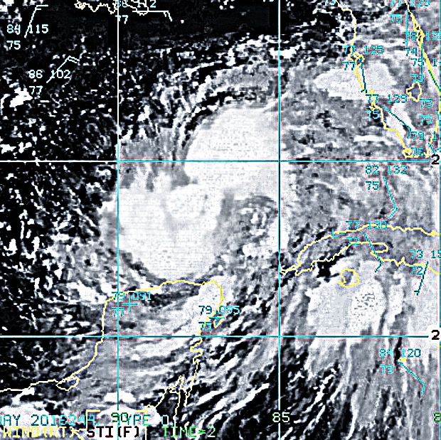
Think we can call that an eye now?
3 likes
The following post is NOT an official forecast and should not be used as such. It is just the opinion of the poster and may or may not be backed by sound meteorological data. It is NOT endorsed by any professional institution including storm2k.org For Official Information please refer to the NHC and NWS products. http://www.nhc.noaa.gov


Re: ATL: HERMINE - Hurricane - Discussion
On Bay news 9 they just reported two gusts on the Pinellas coast of over 70mph, one was 78mph.. I believe southern Pinellas. When that squall came through.
1 likes
-
HenkL
- S2K Supporter
- Posts: 2401
- Joined: Fri Sep 10, 2004 5:33 pm
- Location: Groningen, The Netherlands
- Contact:
Re: ATL: HERMINE - Recon
000
URNT15 KWBC 012241
NOAA3 WXWXA HERMINE HDOB 22 20160901
223200 2843N 08536W 6941 03108 9929 +113 //// 339041 044 041 010 01
223230 2843N 08533W 6949 03093 9934 +107 //// 342036 039 036 004 01
223300 2843N 08531W 6958 03086 9928 +109 //// 351033 035 035 006 01
223330 2843N 08528W 6950 03085 9919 +111 //// 355034 035 035 005 01
223400 2843N 08526W 6958 03073 9911 +115 //// 351036 037 037 004 01
223430 2843N 08523W 6950 03076 9895 +123 +116 348037 037 035 004 00
223500 2843N 08521W 6960 03061 9887 +127 +115 343035 035 037 006 00
223530 2843N 08518W 6952 03063 9887 +121 +120 337032 033 040 003 00
223600 2843N 08516W 6940 03075 9874 +124 //// 336027 029 038 007 01
223630 2843N 08513W 6958 03046 9865 +128 //// 333028 030 033 002 05
223700 2844N 08511W 6972 03028 9864 +129 +120 336023 025 031 000 03
223730 2845N 08509W 6959 03041 9863 +130 +112 337022 022 029 000 00
223800 2846N 08507W 6960 03040 9862 +132 +097 341017 019 028 000 00
223830 2847N 08505W 6961 03035 9855 +134 +103 342013 014 025 000 00
223900 2848N 08503W 6961 03033 9843 +143 +095 331010 012 023 000 00
223930 2849N 08501W 6962 03031 9840 +145 +094 322007 008 023 000 03
224000 2851N 08459W 6959 03033 9840 +144 +104 342007 007 017 000 00
224030 2851N 08457W 6966 03026 9833 +149 +105 309005 006 014 000 00
224100 2853N 08455W 6962 03028 9830 +153 +082 313001 003 014 000 00
224130 2854N 08453W 6963 03026 9826 +156 +082 044001 004 013 000 03
0 likes
-
tropicwatch

- Category 5
- Posts: 3426
- Age: 62
- Joined: Sat Jun 02, 2007 10:01 am
- Location: The Villages, Florida
- Contact:
Re: ATL: HERMINE - Hurricane - Discussion
Dean4Storms wrote:This buoy gusting to 66kts.... Has to be close to the SE Eyewall.
Edit....68kts.
http://www.ndbc.noaa.gov/station_page.php?station=42036
and a pressure 989.6mb
0 likes
Tropicwatch
Agnes 72', Eloise 75, Elena 85', Kate 85', Charley 86', Florence 88', Beryl 94', Dean 95', Erin 95', Opal 95', Earl 98', Georges 98', Ivan 2004', Arlene 2005', Dennis 2005', Ida 2009' Debby 2012' Irma 2017' Michael 2018'
Agnes 72', Eloise 75, Elena 85', Kate 85', Charley 86', Florence 88', Beryl 94', Dean 95', Erin 95', Opal 95', Earl 98', Georges 98', Ivan 2004', Arlene 2005', Dennis 2005', Ida 2009' Debby 2012' Irma 2017' Michael 2018'
-
tolakram
- Admin
- Posts: 20186
- Age: 62
- Joined: Sun Aug 27, 2006 8:23 pm
- Location: Florence, KY (name is Mark)
Re: ATL: HERMINE - Recon

0 likes
M a r k
- - - - -
Join us in chat: Storm2K Chatroom Invite. Android and IOS apps also available.
The posts in this forum are NOT official forecasts and should not be used as such. Posts are NOT endorsed by any professional institution or STORM2K.org. For official information and forecasts, please refer to NHC and NWS products.
- - - - -
Join us in chat: Storm2K Chatroom Invite. Android and IOS apps also available.
The posts in this forum are NOT official forecasts and should not be used as such. Posts are NOT endorsed by any professional institution or STORM2K.org. For official information and forecasts, please refer to NHC and NWS products.
-
HenkL
- S2K Supporter
- Posts: 2401
- Joined: Fri Sep 10, 2004 5:33 pm
- Location: Groningen, The Netherlands
- Contact:
Re: ATL: HERMINE - Recon
000
URNT15 KNHC 012243
AF304 1409A HERMINE HDOB 03 20160901
223330 3024N 08834W 8379 01601 0074 +174 +143 031019 021 /// /// 03
223400 3024N 08831W 8385 01609 0081 +173 +141 029020 021 /// /// 03
223430 3023N 08829W 8386 01612 0085 +169 +150 028019 020 /// /// 03
223500 3022N 08827W 8389 01597 0070 +172 +150 029019 020 /// /// 03
223530 3021N 08824W 8385 01588 0075 +169 +153 023017 018 /// /// 03
223600 3021N 08822W 8389 01602 0086 +168 +154 029017 018 /// /// 03
223630 3020N 08820W 8387 01602 0086 +167 +157 032017 018 017 000 00
223700 3019N 08817W 8384 01608 0085 +168 +154 033020 021 017 000 03
223730 3019N 08815W 8386 01602 0084 +167 +153 034019 021 018 000 00
223800 3019N 08812W 8383 01604 0082 +166 +149 031019 020 019 000 03
223830 3019N 08810W 8387 01600 0081 +165 +148 028021 021 021 000 03
223900 3019N 08807W 8385 01604 0084 +166 +150 031020 021 018 000 03
223930 3019N 08805W 8384 01607 0085 +165 +151 026020 021 017 000 00
224000 3019N 08802W 8367 01624 0084 +170 +142 027021 021 016 000 03
224030 3018N 08800W 8375 01616 0083 +168 +143 029020 021 016 000 03
224100 3018N 08757W 8373 01616 0083 +166 +150 030021 022 016 000 00
224130 3018N 08755W 8372 01614 0082 +168 +144 027021 022 017 000 00
224200 3017N 08752W 8375 01611 0082 +167 +135 027021 022 015 000 00
224230 3017N 08750W 8375 01610 0082 +165 +137 035021 022 016 000 00
224300 3016N 08747W 8373 01612 0081 +165 +139 038022 023 016 000 03
(AF plane en route)
0 likes
-
stormhunter7
- Category 2
- Posts: 763
- Joined: Mon May 26, 2008 3:13 pm
- Location: Panama City Beach, Florida
- Contact:
Re: ATL: HERMINE - Hurricane - Discussion
Product: NOAA Vortex Message (URNT12 KWBC)
Transmitted: 1st day of the month at 22:32Z
Agency: National Oceanic and Atmospheric Administration (NOAA)
Aircraft: Lockheed WP-3D Orion (Reg. Num. N43RF)
Mission: Non-Tasked (not tasked by National Hurricane Center) (flight in the North Atlantic basin)
Mission Identifier: Hermine (Probably storm name)
Observation Number: 14
A. Time of Center Fix: 1st day of the month at 22:08:28Z
B. Center Fix Coordinates: 28°45'N 85°08'W (28.75N 85.1333W)
B. Center Fix Location: 104 statute miles (167 km) to the SSE (162°) from Panama City, FL, USA.
C. Minimum Height at Standard Level: 2,982m (9,783ft) at 700mb
D. Estimated (by SFMR or visually) Maximum Surface Wind Inbound: 57kts (~ 65.6mph)
E. Location of the Estimated Maximum Surface Wind Inbound: 26 nautical miles (30 statute miles) to the ENE/E (79°) of center fix
F. Maximum Flight Level Wind Inbound: From 173° at 60kts (From the S at ~ 69.0mph)
G. Location of Maximum Flight Level Wind Inbound: 65 nautical miles (75 statute miles) to the ENE (74°) of center fix
H. Minimum Sea Level Pressure: 986mb (29.12 inHg)
I. Maximum Flight Level Temp & Pressure Altitude Outside Eye: 15°C (59°F) at a pressure alt. of 3,061m (10,043ft)
J. Maximum Flight Level Temp & Pressure Altitude Inside Eye: 15°C (59°F) at a pressure alt. of 3,060m (10,039ft)
K. Dewpoint Temp (collected at same location as temp inside eye): 8°C (46°F)
K. Sea Surface Temp (collected at same location as temp inside eye): Not Available
L. Eye Character: Open in the east (center has 50% or more, but less than 100%, of eyewall coverage)
M. Eye Shape & Diameter: Circular with a diameter of 25 nautical miles (29 statute miles)
N. Fix Determined By: Penetration, Radar, Wind, Pressure and Temperature
N. Fix Level: 700mb
O. Navigational Fix Accuracy: 0.01 nautical miles
O. Meteorological Accuracy: 2 nautical miles
Remarks Section:
Maximum Flight Level Wind: 69kts (~ 79.4mph) which was observed 40 nautical miles (46 statute miles) to the S (179°) from the flight level center at 20:48:39Z
Maximum Flight Level Temp: 16°C (61°F) which was observed 26 nautical miles (30 statute miles) to the ENE (78°) from the flight level center
Dropsonde Surface Wind at Center: From 65° at 9kts (From the ENE at 10mph)
0 likes
The following post is NOT an official forecast and should not be used as such. It is just the opinion of the poster and may or may not be backed by sound meteorological data. It is NOT endorsed by any professional institution including storm2k.org For Official Information please refer to the NHC and NWS products. http://www.nhc.noaa.gov
-
deltadog03

- Professional-Met

- Posts: 3580
- Joined: Tue Jul 05, 2005 6:16 pm
- Location: Macon, GA
Re: ATL: HERMINE - Hurricane - Discussion
tallywx wrote:Hurricaneman wrote:NDG wrote:It started doing a more NE jog the last couple of hours, I think the NHC landfall spot is good.
Maybe even slightly east of there
The posts in this forum are NOT official forecast and should not be used as such. They are just the opinion of the poster and may or may not be backed by sound meteorological data. They are NOT endorsed by any professional institution or STORM2K. For official information, please refer to products from the National Hurricane Center and National Weather Service.
According to recon fixes in the past hour it's moved 10 ticks to the north and only 2 ticks to the east. That's more N than even NNE. That line extrapolates to Lanark Village or Alligator Point (west of track).
Agreed...its going to have to start really moving NE from here to the coast to hit NHC point IMHO..Recon has been showing a NNE if not a NNNNE *I know that's not real** LOL motion.
2 likes
-
tolakram
- Admin
- Posts: 20186
- Age: 62
- Joined: Sun Aug 27, 2006 8:23 pm
- Location: Florence, KY (name is Mark)
Re: ATL: HERMINE - Hurricane - Discussion
1 likes
M a r k
- - - - -
Join us in chat: Storm2K Chatroom Invite. Android and IOS apps also available.
The posts in this forum are NOT official forecasts and should not be used as such. Posts are NOT endorsed by any professional institution or STORM2K.org. For official information and forecasts, please refer to NHC and NWS products.
- - - - -
Join us in chat: Storm2K Chatroom Invite. Android and IOS apps also available.
The posts in this forum are NOT official forecasts and should not be used as such. Posts are NOT endorsed by any professional institution or STORM2K.org. For official information and forecasts, please refer to NHC and NWS products.
-
Aric Dunn
- Category 5
- Posts: 21238
- Age: 43
- Joined: Sun Sep 19, 2004 9:58 pm
- Location: Ready for the Chase.
- Contact:
Re: ATL: HERMINE - Hurricane - Discussion
doing another ne wobble..
0 likes
Note: If I make a post that is brief. Please refer back to previous posts for the analysis or reasoning. I do not re-write/qoute what my initial post said each time.
If there is nothing before... then just ask
Space & Atmospheric Physicist, Embry-Riddle Aeronautical University,
I believe the sky is falling...
If there is nothing before... then just ask
Space & Atmospheric Physicist, Embry-Riddle Aeronautical University,
I believe the sky is falling...
-
tropicwatch
- Category 5
- Posts: 3426
- Age: 62
- Joined: Sat Jun 02, 2007 10:01 am
- Location: The Villages, Florida
- Contact:
Re: ATL: HERMINE - Hurricane - Discussion
Ruh Roh!
0 likes
Tropicwatch
Agnes 72', Eloise 75, Elena 85', Kate 85', Charley 86', Florence 88', Beryl 94', Dean 95', Erin 95', Opal 95', Earl 98', Georges 98', Ivan 2004', Arlene 2005', Dennis 2005', Ida 2009' Debby 2012' Irma 2017' Michael 2018'
Agnes 72', Eloise 75, Elena 85', Kate 85', Charley 86', Florence 88', Beryl 94', Dean 95', Erin 95', Opal 95', Earl 98', Georges 98', Ivan 2004', Arlene 2005', Dennis 2005', Ida 2009' Debby 2012' Irma 2017' Michael 2018'
-
StormHunter72
- Tropical Storm

- Posts: 166
- Joined: Wed May 25, 2016 6:36 am
- Location: Nature Coast
Re: ATL: HERMINE - Hurricane - Discussion
I agree just had at least 50mph hereronjon wrote:Very heavy squall as I speak in hernando beach..wind gusts to 60 mph..torrential rain... hoping I don't lose power..winds have really come up the last hour
0 likes
The following post is NOT an official forecast and should not be used as such. It is just the opinion of the poster and may or may not be backed by sound meteorological data. It is NOT endorsed by any professional institution including storm2k.org For Official Information please refer to the NHC and NWS products.

Re: ATL: HERMINE - Hurricane - Discussion
Aric Dunn wrote:doing another ne wobble..
Yeap, another big NE wobble.
224130 2854N 08453W 6963 03026 9826 +156 +082 044001 004 013 000 03
0 likes

-
RazorTracks
- Tropical Wave

- Posts: 9
- Age: 38
- Joined: Sun Aug 28, 2016 4:59 pm
- Location: Arkansas
Re: ATL: HERMINE - Hurricane - Discussion
tolakram wrote:Just off the FTP site

That's avatar worthy right there, simply beautiful. My current avatar is little 99L when she was still a baby, going to have to update it to a more current version.
Don't want to water down the thread too much, but I do want to say that this is the first experience I've had following a TC from birth to landfall and its been riveting. I have learned more from the people on this site than I ever have regarding weather, and that's saying a lot.
What's the consensus on movement right now? I'm trying to watch it closely and can't quite pinpoint where it's ultimately heading.
1 likes
***NOT a professional, posts are opinion ONLY***
Who is online
Users browsing this forum: No registered users and 52 guests