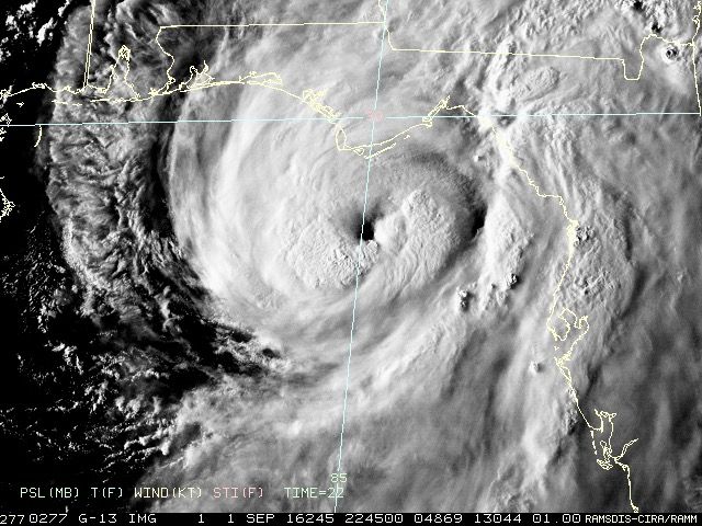
panamatropicwatch wrote:Hermine's eye is looking impressive on enhanced satellite.

Eye appears to be tightening up on radar as well.. WOW... that is a great IR sat photo of a strengthening hurricane!
Moderator: S2k Moderators

panamatropicwatch wrote:Hermine's eye is looking impressive on enhanced satellite.
Aric Dunn wrote:Frank P wrote:NDG wrote:
Yeap, another big NE wobble.
224130 2854N 08453W 6963 03026 9826 +156 +082 044001 004 013 000 03
Looks NNE to NE to me on radar... radar tells the story now on movement..
no recon does..

RazorTracks wrote:panamatropicwatch wrote:
Ruh Roh!
I saved and enhanced the last frame of that satellite image to make up for some of the darkness, and, well, I'll just let it tell the story:
I'd say that's the best the eye has looked thus far.
HurricaneBelle wrote:TPAcane wrote:I think people tend to forget or have never experienced SUSTAINED high winds. That was a quick blast and it was kinda scary. For those near the eye of a hurricane it is surreal. You think how does a structure stand the pressure. Even a strong 60MPH sustained storm is frightening let alone a CAT 1. A lot of folks who have never experienced this and hopefully never will...they think these bands are a hurricane...never to experience the fright under a CDO. For those that say this is just a wimpy CAT 1...75-80mph or even 50mph sustained winds are very unnerving if not downright frightening. These bands always remind me of a big monster breathing, like a beast taunting, giving the storm almost a life force of its own...huffing and puffing. Always in awe....and again...prayers to those where this is headed....truly anything other than a strong winter cold front is not fun...
This is why it always aggravates me when, say, a tropical storm is brewing and someone says "oh we get a 40 MPH wind in a summer thunderstorm". Yeah, for about one minute or less with some gusts. Not hours of 40 MPH winds, which is a completely different thing.


stormhunter7 wrote:
Think we can call that an eye now?
Hurricane Andrew wrote:If this had 12-18 more hours over water...wow

Frank P wrote:panamatropicwatch wrote:Hermine's eye is looking impressive on enhanced satellite.
Eye appears to be tightening up on radar as well.. WOW... that is a great IR sat photo of a strengthening hurricane!


Users browsing this forum: No registered users and 85 guests