You forget all it takes is one of the mini vortices to drop by and you forget it only had sustained winds of less than 70, which still is nothing to sneeze at, particularly where there are many trees about. And usually a hurricane can have multiple mini vortices which can randomlly hit without any warning. Trust me, I know.
Steve wrote:I think from a historical perspective, people are blowing the potential and look out of proportion. TWC was hawking the buoy the center just past by and promoted the gusts. Sustained was 50s which is plenty strong enough, but I'm thinking the NHC has been overplaying intensity for at least a few years. I haven't really seen a lot of sustained winds with any recent tropical systems measured on land. Obviously the winds will usually be stronger over water.
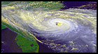
This is a cool storm but it's not some vicious Cat 3/4/5. Dry air slots have mixed in, there is no real core and the eye is ragged. It looks like a high end TS/low end H. I'm not downing on it, but people should keep their perspective.


