ATL: HERMINE - Post-Tropical - Discussion

Moderator: S2k Moderators

Message
Author
RL3AO
Moderator-Pro Met
Moderator-Pro Met
Posts: 16308
Joined: Thu Jun 14, 2007 10:03 pm
Location: NC

Re: ATL: HERMINE - Hurricane - Discussion

#8521 Postby RL3AO » Thu Sep 01, 2016 7:02 pm

chaser1 wrote:I'm guessing that recon will continue to fly right up to eye landfall, or does that pose an enchanced risk to crew and plane? Really looks like Hermine wants to make a push to Cat 2. Time frame seems a bit too close though


They'll fly until landfall. If they're at 10000 ft there isn't a risk.
0 likes   

Soonercane

Re: ATL: HERMINE - Hurricane - Discussion

#8522 Postby Soonercane » Thu Sep 01, 2016 7:03 pm

Does anyone think this about to undergo extratropical transition, with stronger winds aloft not translating to the sfc, and the wind field enlarging (combined with the upper jet dynamics on its northeast side)?
0 likes   

User avatar
ronjon
Category 5
Category 5
Posts: 4822
Joined: Fri Aug 19, 2005 5:17 pm
Location: Hernando Beach, FL

Re: ATL: HERMINE - Hurricane - Discussion

#8523 Postby ronjon » Thu Sep 01, 2016 7:03 pm

Wow down to 983 mb!

BULLETIN
HURRICANE HERMINE INTERMEDIATE ADVISORY NUMBER 18A
NWS NATIONAL HURRICANE CENTER MIAMI FL AL092016
800 PM EDT THU SEP 01 2016

...HERMINE CONTINUING TO STRENGTHEN...
...LIFE-THREATENING SURGE AND FLOODING RAINS EXPECTED...


SUMMARY OF 800 PM EDT...0000 UTC...INFORMATION
----------------------------------------------
LOCATION...29.1N 84.8W
ABOUT 45 MI...70 KM SSE OF APALACHICOLA FLORIDA
ABOUT 105 MI...170 KM W OF CEDAR KEY FLORIDA
MAXIMUM SUSTAINED WINDS...80 MPH...130 KM/H
PRESENT MOVEMENT...NNE OR 30 DEGREES AT 14 MPH...22 KM/H
MINIMUM CENTRAL PRESSURE...983 MB...29.03 INCHES
0 likes   

User avatar
chaser1
S2K Supporter
S2K Supporter
Posts: 5467
Age: 64
Joined: Sat Oct 15, 2005 5:59 pm
Location: Longwood, Fl

Re: ATL: HERMINE - Hurricane - Discussion

#8524 Postby chaser1 » Thu Sep 01, 2016 7:04 pm

artist wrote:Did you make it in?
Aric Dunn wrote:dekle beach and horseshoe are going to take the main blow from this... right front quad..


Horseshoe Beach is the last place you'd wanna be right now. I've only been there once but there's nothing there that would not be under water in a significant surge. Anyone staying there has a death wish (and thats coming from a crazy person that chases 'em lol)
1 likes   
Andy D

(For official information, please refer to the NHC and NWS products.)

seahawkjd
S2K Supporter
S2K Supporter
Posts: 632
Joined: Wed Sep 10, 2003 4:12 pm
Location: Morehead City, NC
Contact:

Re: ATL: HERMINE - Hurricane - Discussion

#8525 Postby seahawkjd » Thu Sep 01, 2016 7:04 pm

Rookie question, but is the friction and shape of the land its approaching helping to tighten it up? I remember years ago Derek used to talk about that happening with some storms.
1 likes   
Gloria, Hugo, Emily, Bertha, Bonnie, Dennis (twice), Fran, Floyd, Isabel, Irene, Arthur, Matthew, Florence, Dorian (and many tropical storms and nor'easters).

User avatar
AdamFirst
S2K Supporter
S2K Supporter
Posts: 2491
Age: 36
Joined: Thu Aug 14, 2008 10:54 am
Location: Port Saint Lucie, FL

Re: ATL: HERMINE - Hurricane - Discussion

#8526 Postby AdamFirst » Thu Sep 01, 2016 7:05 pm

Sending best wishes to anyone in the path of this storm...it's got that sinister look as it rears up for landfall.
0 likes   
Dolphins Marlins Canes Golden Panthers HEAT
Andrew 1992 - Irene 1999 - Frances 2004 - Jeanne 2004 - Wilma 2005 - Fay 2008 - Isaac 2012 - Matthew 2016 - Irma 2017 - Dorian 2019 - Ian 2022 - Nicole 2022 - Milton 2024

User avatar
chaser1
S2K Supporter
S2K Supporter
Posts: 5467
Age: 64
Joined: Sat Oct 15, 2005 5:59 pm
Location: Longwood, Fl

Re: ATL: HERMINE - Hurricane - Discussion

#8527 Postby chaser1 » Thu Sep 01, 2016 7:05 pm

Soonercane wrote:Does anyone think this about to undergo extratropical transition, with stronger winds aloft not translating to the sfc, and the wind field enlarging (combined with the upper jet dynamics on its northeast side)?


Given the expanding wind fields one would think maybe. Then you take a look at the satellite and look at that core, and try to make a case for undergoing extratropical transitioning.
0 likes   
Andy D

(For official information, please refer to the NHC and NWS products.)

User avatar
Hybridstorm_November2001
S2K Supporter
S2K Supporter
Posts: 2811
Joined: Sat Aug 21, 2004 2:50 pm
Location: SW New Brunswick, Canada
Contact:

Re: ATL: HERMINE - Hurricane - Discussion

#8528 Postby Hybridstorm_November2001 » Thu Sep 01, 2016 7:07 pm

Stay safe everyone in Hermine's path.
1 likes   

BRweather
Category 1
Category 1
Posts: 331
Joined: Wed Aug 31, 2016 8:50 am
Location: Baton Rouge, LA

Re: ATL: HERMINE - Hurricane - Discussion

#8529 Postby BRweather » Thu Sep 01, 2016 7:07 pm

I am not trying to downplay this storm, but even though it is strengthening, I am seeing no visuals that make my jaw drop. TWC has someone on Apalachicola and the eye is not too far from him and it does not look too significant.

Also the rains have really thinned out and the heavy rains are in isolated bans and they are not training as bad.

We will have to see what the aftermath is, but I am getting the sense the area will be okay.

Edit: The surge prone areas look at the moment where the most damage will occur
Last edited by BRweather on Thu Sep 01, 2016 7:08 pm, edited 1 time in total.
1 likes   

User avatar
chaser1
S2K Supporter
S2K Supporter
Posts: 5467
Age: 64
Joined: Sat Oct 15, 2005 5:59 pm
Location: Longwood, Fl

Re: ATL: HERMINE - Hurricane - Discussion

#8530 Postby chaser1 » Thu Sep 01, 2016 7:08 pm

NWFL56 wrote:
chaser1 wrote:
Hurricane Andrew wrote:If this had 12-18 more hours over water...wow


Thank heaven it didn't! Been peaking at sat. pics all day while busy with work. Figured a nighttime landfall with a borderline hurricane. This is not looking borderline; At least not in the last couple of hours. Aric, you ever fly on down here to chase this? Anyone else out there in or near Wakulla county with video/pics?

I was in Wakulla. I left. Lol. In Tallahassee now.


NOOOOOO, you could've stayed at a hotel on 98 I think, just outside the storm surge zone. Then again, far less down there to film or watch. Marsh and trees
0 likes   
Andy D

(For official information, please refer to the NHC and NWS products.)

Noles2016
Tropical Depression
Tropical Depression
Posts: 58
Joined: Tue Aug 30, 2016 9:15 pm

Re: ATL: HERMINE - Hurricane - Discussion

#8531 Postby Noles2016 » Thu Sep 01, 2016 7:09 pm

chaser1 wrote:
artist wrote:Did you make it in?
Aric Dunn wrote:dekle beach and horseshoe are going to take the main blow from this... right front quad..


Horseshoe Beach is the last place you'd wanna be right now. I've only been there once but there's nothing there that would not be under water in a significant surge. Anyone staying there has a death wish (and thats coming from a crazy person that chases 'em lol)


Anyone along the coast of the Bay knows better... at least you'd think... we flood for some afternoon thunderstorms that roll in from the Gulf!
0 likes   

User avatar
NDG
S2K Supporter
S2K Supporter
Posts: 15446
Joined: Sun Jul 09, 2006 10:14 pm
Location: Orlando, FL

Re: ATL: HERMINE - Hurricane - Discussion

#8532 Postby NDG » Thu Sep 01, 2016 7:10 pm

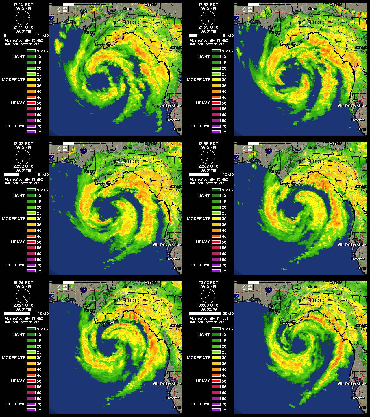
A strengthening hurricane at landfall, not good!!!

Image
2 likes   

User avatar
Kazmit
Category 5
Category 5
Posts: 2124
Age: 22
Joined: Mon Jul 25, 2016 8:49 am
Location: Williamsburg, VA / Bermuda

Re: ATL: HERMINE - Hurricane - Discussion

#8533 Postby Kazmit » Thu Sep 01, 2016 7:10 pm

Hermine's a big storm... outflow extends from Atlanta down to the western tip of Cuba. :eek:
Image
0 likes   
Igor 2010, Sandy 2012, Fay 2014, Gonzalo 2014, Joaquin 2015, Nicole 2016, Humberto 2019

I am only a tropical weather enthusiast. My predictions are not official and may or may not be backed by sound meteorological data. For official information, please refer to the NHC and NWS products.

Aric Dunn
Category 5
Category 5
Posts: 21238
Age: 42
Joined: Sun Sep 19, 2004 9:58 pm
Location: Ready for the Chase.
Contact:

Re: ATL: HERMINE - Hurricane - Discussion

#8534 Postby Aric Dunn » Thu Sep 01, 2016 7:11 pm

IT has slowed down quite a bit again.
0 likes   
Note: If I make a post that is brief. Please refer back to previous posts for the analysis or reasoning. I do not re-write/qoute what my initial post said each time.
If there is nothing before... then just ask :)

Space & Atmospheric Physicist, Embry-Riddle Aeronautical University,
I believe the sky is falling...

User avatar
chaser1
S2K Supporter
S2K Supporter
Posts: 5467
Age: 64
Joined: Sat Oct 15, 2005 5:59 pm
Location: Longwood, Fl

Re: ATL: HERMINE - Hurricane - Discussion

#8535 Postby chaser1 » Thu Sep 01, 2016 7:12 pm

Really surprised that the Orlando area has gotten as little as it has today. That said, i'm guessing the S.E. quad might bring in some bands that'll finally rotate around and over us. Would think that what slight risk of tornados might play out along these strong feeder bands coming ashore on the west coast.
0 likes   
Andy D

(For official information, please refer to the NHC and NWS products.)

User avatar
chaser1
S2K Supporter
S2K Supporter
Posts: 5467
Age: 64
Joined: Sat Oct 15, 2005 5:59 pm
Location: Longwood, Fl

Re: ATL: HERMINE - Hurricane - Discussion

#8536 Postby chaser1 » Thu Sep 01, 2016 7:12 pm

Aric Dunn wrote:IT has slowed down quite a bit again.


deepening perhaps?
0 likes   
Andy D

(For official information, please refer to the NHC and NWS products.)

User avatar
GCANE
S2K Supporter
S2K Supporter
Posts: 11497
Joined: Mon Oct 22, 2007 8:03 am

Re: ATL: HERMINE - Hurricane - Discussion

#8537 Postby GCANE » Thu Sep 01, 2016 7:13 pm

Stay safe everyone. Hopefully, everyone has taken the best precautions they can. Prayers are with you.
Last edited by GCANE on Thu Sep 01, 2016 7:14 pm, edited 1 time in total.
1 likes   

Aric Dunn
Category 5
Category 5
Posts: 21238
Age: 42
Joined: Sun Sep 19, 2004 9:58 pm
Location: Ready for the Chase.
Contact:

Re: ATL: HERMINE - Hurricane - Discussion

#8538 Postby Aric Dunn » Thu Sep 01, 2016 7:14 pm

chaser1 wrote:
Aric Dunn wrote:IT has slowed down quite a bit again.


deepening perhaps?


quite likely.
1 likes   
Note: If I make a post that is brief. Please refer back to previous posts for the analysis or reasoning. I do not re-write/qoute what my initial post said each time.
If there is nothing before... then just ask :)

Space & Atmospheric Physicist, Embry-Riddle Aeronautical University,
I believe the sky is falling...

tolakram
Admin
Admin
Posts: 20010
Age: 62
Joined: Sun Aug 27, 2006 8:23 pm
Location: Florence, KY (name is Mark)

Re: ATL: HERMINE - Hurricane - Discussion

#8539 Postby tolakram » Thu Sep 01, 2016 7:14 pm

0 likes   
M a r k
- - - - -
Join us in chat: Storm2K Chatroom Invite. Android and IOS apps also available.

The posts in this forum are NOT official forecasts and should not be used as such. Posts are NOT endorsed by any professional institution or STORM2K.org. For official information and forecasts, please refer to NHC and NWS products.

BRweather
Category 1
Category 1
Posts: 331
Joined: Wed Aug 31, 2016 8:50 am
Location: Baton Rouge, LA

Re: ATL: HERMINE - Hurricane - Discussion

#8540 Postby BRweather » Thu Sep 01, 2016 7:15 pm

If I am Jim Cantore,

I am trying to get to Perry.
1 likes   


Return to “2016”

Who is online

Users browsing this forum: No registered users and 5 guests