I'm going to guess this will be similar to Katrina 2005 in south Florida
The posts in this forum are NOT official forecast and should not be used as such. They are just the opinion of the poster and may or may not be backed by sound meteorological data. They are NOT endorsed by any professional institution or STORM2K. For official information, please refer to products from the National Hurricane Center and National Weather Service.
ATL: HERMINE - Post-Tropical - Discussion
Moderator: S2k Moderators
-
Hurricaneman

- Category 5

- Posts: 7404
- Age: 45
- Joined: Tue Aug 31, 2004 3:24 pm
- Location: central florida
-
adam0983
Re: ATL: HERMINE - Hurricane - Discussion
Hurricane Hermine has always loved the night. Strengthen baby strengthen. Doesn't want to hit the land yet. Just an opinion not a forecast.
1 likes

Re: ATL: HERMINE - Hurricane - Discussion
This storm has been a bit of a tornado producer. New warning.

0 likes
-
RazorTracks
- Tropical Wave

- Posts: 9
- Age: 38
- Joined: Sun Aug 28, 2016 4:59 pm
- Location: Arkansas
Re: ATL: HERMINE - Hurricane - Discussion
Steve wrote:I think from a historical perspective, people are blowing the potential and look out of proportion. TWC was hawking the buoy the center just past by and promoted the gusts. Sustained was 50s which is plenty strong enough, but I'm thinking the NHC has been overplaying intensity for at least a few years. I haven't really seen a lot of sustained winds with any recent tropical systems measured on land. Obviously the winds will usually be stronger over water.
This is a cool storm but it's not some vicious Cat 3/4/5. Dry air slots have mixed in, there is no real core and the eye is ragged. It looks like a high end TS/low end H. I'm not downing on it, but people should keep their perspective.
Man, I don't know about you but I'm here because I love to watch, learn, and follow anything relating to weather - not to see livelihoods and swaths of land destroyed. The fact that it turned into a hurricane at all had me excited, just to see the entire event unfold from day one. I don't care that it's not a Cat 3/4/5, in fact that's a good thing because we can still get our weather fix while not TOO much harm is on its way.
I'll never understand those that have your attitude, like "oh yeah it's a hurricane, but I've seen SO much worse than that!" I don't think anyone here is disappointed but you.
0 likes
***NOT a professional, posts are opinion ONLY***
-
SeGaBob
Re: ATL: HERMINE - Hurricane - Discussion
i'm getting anxious...
Btw we had a outer band drop a 1/2 inch in 10 minutes earllier.
Btw we had a outer band drop a 1/2 inch in 10 minutes earllier.
0 likes

Re: ATL: HERMINE - Hurricane - Discussion
adam0983 wrote:Hurricane Hermine has always loved the night. Strengthen baby strengthen. Doesn't want to hit the land yet. Just an opinion not a forecast.
Actually, Hermine has hated the night and loved the mornings. But that was as an Invest and a depression.
and "strengthen baby strengthen"????
2 likes
-
Aric Dunn
- Category 5
- Posts: 21238
- Age: 43
- Joined: Sun Sep 19, 2004 9:58 pm
- Location: Ready for the Chase.
- Contact:
Re: ATL: HERMINE - Hurricane - Discussion
BRweather wrote:If I am Jim Cantore,
I am trying to get to Perry.
from the looks of it may be to far north will end of on the north quad. horseshoe beach or dekle beach will have the highest SE quad winds.
0 likes
Note: If I make a post that is brief. Please refer back to previous posts for the analysis or reasoning. I do not re-write/qoute what my initial post said each time.
If there is nothing before... then just ask
Space & Atmospheric Physicist, Embry-Riddle Aeronautical University,
I believe the sky is falling...
If there is nothing before... then just ask
Space & Atmospheric Physicist, Embry-Riddle Aeronautical University,
I believe the sky is falling...

Re: ATL: HERMINE - Hurricane - Discussion
Aric Dunn wrote:chaser1 wrote:Aric Dunn wrote:IT has slowed down quite a bit again.
deepening perhaps?
quite likely.
I'm guessing we might soon see a little bit of an eastward jerk in reaction to that ball of convection swinging up and around from the south. Game of inches for those on the ground. Say?? If you already responded I missed it, but did you make it down here to chase?
0 likes
Andy D
(For official information, please refer to the NHC and NWS products.)
(For official information, please refer to the NHC and NWS products.)
Re: ATL: HERMINE - Hurricane - Discussion
Hurricaneman wrote:I'm going to guess this will be similar to Katrina 2005 in south Florida
The posts in this forum are NOT official forecast and should not be used as such. They are just the opinion of the poster and may or may not be backed by sound meteorological data. They are NOT endorsed by any professional institution or STORM2K. For official information, please refer to products from the National Hurricane Center and National Weather Service.
The storm perhaps, but the construction standards of buildings and the amount trees that will go down.. no .. Tallahassee has a Tree City USA designation.. lots of trees on cars, roofs, etc. will occur tonight.
2 likes
-
Aric Dunn
- Category 5
- Posts: 21238
- Age: 43
- Joined: Sun Sep 19, 2004 9:58 pm
- Location: Ready for the Chase.
- Contact:
Re: ATL: HERMINE - Hurricane - Discussion
chaser1 wrote:Aric Dunn wrote:chaser1 wrote:
deepening perhaps?
quite likely.
I'm guessing we might soon see a little bit of an eastward jerk in reaction to that ball of convection swinging up and around from the south. Game of inches for those on the ground. Say?? If you already responded I missed it, but did you make it down here to chase?
yep last two recon passes showed more of ne component.
0 likes
Note: If I make a post that is brief. Please refer back to previous posts for the analysis or reasoning. I do not re-write/qoute what my initial post said each time.
If there is nothing before... then just ask
Space & Atmospheric Physicist, Embry-Riddle Aeronautical University,
I believe the sky is falling...
If there is nothing before... then just ask
Space & Atmospheric Physicist, Embry-Riddle Aeronautical University,
I believe the sky is falling...
Re: ATL: HERMINE - Hurricane - Discussion
psyclone wrote:Looks like an increasing chance of a hurricane landfall in the big bend/forgotten coast region. Hurricanes never hit there...except when they do. Imagine if we had accurate tropical cyclone maps over a 1000 year period or more. No doubt we'd find no one is exempt..but it's easy to be fooled by long stretches of luck...which can last a century or more. there's no doubt that some stretches of coast are more vulnerable than others but lower risk doesn't = no risk. It's easy to be fooled by small sample sizes. So, Georgia coast, NE Florida coast, Tampa Bay...and other places showing off remarkable luck streaks just remember your number will eventually pop in the game that is tropical roulette.
I had stated this before as well. I believe we go in cyclical patterns. Louisiana and Texas had a stretch of activity, carolina did too. Florida's time may be up.
1 likes
-
terstorm1012

- S2K Supporter

- Posts: 1314
- Age: 44
- Joined: Fri Sep 10, 2004 5:36 pm
- Location: Millersburg, PA
Re: ATL: HERMINE - Hurricane - Discussion
being reported Recon found 100mph winds just above the surface. this escalated quickly.
Last edited by terstorm1012 on Thu Sep 01, 2016 7:20 pm, edited 1 time in total.
2 likes
my posts in this forum are NOT official forecast and should not be used as such. They are just my opinion (to which I welcome challenges!) and may or may not be backed by sound meteorological data. They are NOT endorsed by any professional institution or storm2k.org. For official information, please refer to the NHC and NWS products

Re: ATL: HERMINE - Hurricane - Discussion
Hammy wrote:Alyono wrote:... And as an aside this seems to be the first hurricane since 1966 to landfall between Cedar Key and Apalachicola.
That's bad news, because when any area hasn't had a hurricane for such a long period, most people living there assume it won't happen again.
1 likes

Re: ATL: HERMINE - Hurricane - Discussion
I must say I'm quite surprised this managed to organize as it did, it was starting to remind me of Ana in 2013 earlier. One thing I'm wondering aside from the obviously better upper environment--is the shape of the coastline partially responsible for intensification, or is it too low in elevation to matter?
0 likes
The above post is not official and should not be used as such. It is the opinion of the poster and may or may not be backed by sound meteorological data. It is not endorsed by any professional institution or storm2k.org. For official information, please refer to the NHC and NWS products.
-
Aric Dunn
- Category 5
- Posts: 21238
- Age: 43
- Joined: Sun Sep 19, 2004 9:58 pm
- Location: Ready for the Chase.
- Contact:
Re: ATL: HERMINE - Hurricane - Discussion
chaser1 wrote:Aric Dunn wrote:chaser1 wrote:
deepening perhaps?
quite likely.
I'm guessing we might soon see a little bit of an eastward jerk in reaction to that ball of convection swinging up and around from the south. Game of inches for those on the ground. Say?? If you already responded I missed it, but did you make it down here to chase?
no plane was late and nothing else available close by. ill miss landfall by a few hours
0 likes
Note: If I make a post that is brief. Please refer back to previous posts for the analysis or reasoning. I do not re-write/qoute what my initial post said each time.
If there is nothing before... then just ask
Space & Atmospheric Physicist, Embry-Riddle Aeronautical University,
I believe the sky is falling...
If there is nothing before... then just ask
Space & Atmospheric Physicist, Embry-Riddle Aeronautical University,
I believe the sky is falling...
-
Aric Dunn
- Category 5
- Posts: 21238
- Age: 43
- Joined: Sun Sep 19, 2004 9:58 pm
- Location: Ready for the Chase.
- Contact:
Re: ATL: HERMINE - Hurricane - Discussion
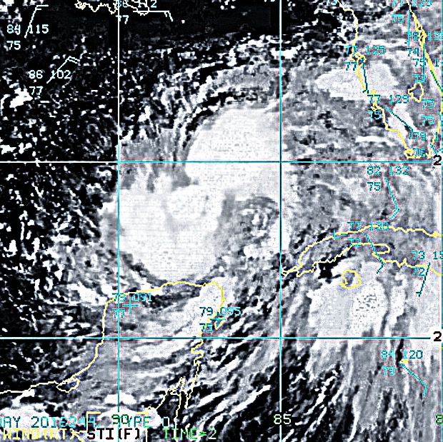
eye continuing to contract and deeper convection working its way into a somewhat coherent eyewall. cat 2 before landfall is still quite possible.
2 likes
Note: If I make a post that is brief. Please refer back to previous posts for the analysis or reasoning. I do not re-write/qoute what my initial post said each time.
If there is nothing before... then just ask
Space & Atmospheric Physicist, Embry-Riddle Aeronautical University,
I believe the sky is falling...
If there is nothing before... then just ask
Space & Atmospheric Physicist, Embry-Riddle Aeronautical University,
I believe the sky is falling...
Re: ATL: HERMINE - Hurricane - Discussion
Once again watch the sleepers that cross the Atlantic.I am with FrankP and I may of dropped by for one up to 90mph at his place built like a rock!  I hope to many vortices do not come down you fellas out there I hated those during Georges.
0 likes

Re: ATL: HERMINE - Hurricane - Discussion
RazorTracks wrote:Steve wrote:I think from a historical perspective, people are blowing the potential and look out of proportion. TWC was hawking the buoy the center just past by and promoted the gusts. Sustained was 50s which is plenty strong enough, but I'm thinking the NHC has been overplaying intensity for at least a few years. I haven't really seen a lot of sustained winds with any recent tropical systems measured on land. Obviously the winds will usually be stronger over water.
This is a cool storm but it's not some vicious Cat 3/4/5. Dry air slots have mixed in, there is no real core and the eye is ragged. It looks like a high end TS/low end H. I'm not downing on it, but people should keep their perspective.
Man, I don't know about you but I'm here because I love to watch, learn, and follow anything relating to weather - not to see livelihoods and swaths of land destroyed. The fact that it turned into a hurricane at all had me excited, just to see the entire event unfold from day one. I don't care that it's not a Cat 3/4/5, in fact that's a good thing because we can still get our weather fix while not TOO much harm is on its way.
I'll never understand those that have your attitude, like "oh yeah it's a hurricane, but I've seen SO much worse than that!" I don't think anyone here is disappointed but you.
You missed all my points and mischaracterized me having an attitude I never even thought of. Not hating, but people are being impacted now. So in deference to that and an intensifying storm close to landfall, I'm not going to address all that again. I'll just say that people need to be realistic and factual and not be hyping stuff up. It was spurned by a comment on TWC.
Last edited by Steve on Thu Sep 01, 2016 7:29 pm, edited 2 times in total.
1 likes
-
tropicwatch

- Category 5
- Posts: 3426
- Age: 62
- Joined: Sat Jun 02, 2007 10:01 am
- Location: The Villages, Florida
- Contact:
Re: ATL: HERMINE - Hurricane - Discussion
Aric Dunn wrote:eye continuing to contract and deeper convection working its way into a somewhat coherent eyewall. cat 2 before landfall is still quite possible.
I thought it was shrinking too, not good.
0 likes
Tropicwatch
Agnes 72', Eloise 75, Elena 85', Kate 85', Charley 86', Florence 88', Beryl 94', Dean 95', Erin 95', Opal 95', Earl 98', Georges 98', Ivan 2004', Arlene 2005', Dennis 2005', Ida 2009' Debby 2012' Irma 2017' Michael 2018'
Agnes 72', Eloise 75, Elena 85', Kate 85', Charley 86', Florence 88', Beryl 94', Dean 95', Erin 95', Opal 95', Earl 98', Georges 98', Ivan 2004', Arlene 2005', Dennis 2005', Ida 2009' Debby 2012' Irma 2017' Michael 2018'
-
Hurricaneman
- Category 5
- Posts: 7404
- Age: 45
- Joined: Tue Aug 31, 2004 3:24 pm
- Location: central florida
Re: ATL: HERMINE - Hurricane - Discussion
pouring buckets and 40mph gusts maybe higher, this is producing as expected in central Florida and over performing in the panhandle
The posts in this forum are NOT official forecast and should not be used as such. They are just the opinion of the poster and may or may not be backed by sound meteorological data. They are NOT endorsed by any professional institution or STORM2K. For official information, please refer to products from the National Hurricane Center and National Weather Service.
The posts in this forum are NOT official forecast and should not be used as such. They are just the opinion of the poster and may or may not be backed by sound meteorological data. They are NOT endorsed by any professional institution or STORM2K. For official information, please refer to products from the National Hurricane Center and National Weather Service.
Last edited by Hurricaneman on Thu Sep 01, 2016 7:30 pm, edited 1 time in total.
1 likes
Who is online
Users browsing this forum: No registered users and 6 guests