ATL: HERMINE - Post-Tropical - Discussion

Moderator: S2k Moderators

Message
Author
ZX12R
S2K Supporter
S2K Supporter
Posts: 82
Joined: Mon Aug 29, 2016 8:09 pm

Re: ATL: HERMINE - Hurricane - Discussion

#8601 Postby ZX12R » Thu Sep 01, 2016 7:49 pm

Aric Dunn wrote:cedar key is getting pounded. likely gust to hurricane.
http://hurricanetrack.com/cam2.html


Water level seems to be approaching what it was several hours ago, now building to the high tide level. Surf is more angry or energetic than before.
1 likes   

User avatar
cjrciadt
S2K Supporter
S2K Supporter
Posts: 1616
Joined: Mon Aug 22, 2005 1:11 pm
Location: Kissimmee, FL

Re: ATL: HERMINE - Hurricane - Discussion

#8602 Postby cjrciadt » Thu Sep 01, 2016 7:50 pm

Multiple Tornado Warnings in CFL
2 likes   

caneman
Category 5
Category 5
Posts: 1447
Joined: Fri Sep 05, 2014 5:44 am
Location: Clearwater Beach, Fl

Re: ATL: HERMINE - Hurricane - Discussion

#8603 Postby caneman » Thu Sep 01, 2016 7:50 pm

NDG wrote:I wouldn't doubt if the next nasty squall approaching west central FL has hurricane force winds in gusts.

http://i20.photobucket.com/albums/b245/ ... qpjlvf.gif

I'm concerned you're right. Have to admit, I didn't really prepare like I should have seeing that It was heading to appalachacola. Now it looks close to Perry.
Last edited by Ntxw on Thu Sep 01, 2016 7:53 pm, edited 1 time in total.
Reason: Removed img tags
1 likes   

User avatar
terstorm1012
S2K Supporter
S2K Supporter
Posts: 1314
Age: 43
Joined: Fri Sep 10, 2004 5:36 pm
Location: Millersburg, PA

Re: ATL: HERMINE - Hurricane - Discussion

#8604 Postby terstorm1012 » Thu Sep 01, 2016 7:51 pm

galaxy401 wrote:
Aric Dunn wrote:
galaxy401 wrote:
Where did you hear about this?


it was the 86kt on the last recon minob.


That was the flight winds. The first post seemed to implied the surface winds.


it ws the first recon pass, and not at the surface, at around 1000mb level. sorry for the confusion and i should have provided the link where I saw it. I apologize. https://twitter.com/wxmeddler/status/771501317265104896 in the SE eyewall
Last edited by terstorm1012 on Thu Sep 01, 2016 7:53 pm, edited 1 time in total.
2 likes   
my posts in this forum are NOT official forecast and should not be used as such. They are just my opinion (to which I welcome challenges!) and may or may not be backed by sound meteorological data. They are NOT endorsed by any professional institution or storm2k.org. For official information, please refer to the NHC and NWS products

User avatar
chris_fit
Category 5
Category 5
Posts: 3222
Age: 42
Joined: Wed Sep 10, 2003 11:58 pm
Location: Tampa Bay Area, FL

Re: ATL: HERMINE - Hurricane - Discussion

#8605 Postby chris_fit » Thu Sep 01, 2016 7:51 pm

You guys think that big feeder off shore will make it to the bay area? I'm doubting it.... And if it does, it will be much weaker IMO
0 likes   

RL3AO
Moderator-Pro Met
Moderator-Pro Met
Posts: 16308
Joined: Thu Jun 14, 2007 10:03 pm
Location: NC

Re: ATL: HERMINE - Hurricane - Discussion

#8606 Postby RL3AO » Thu Sep 01, 2016 7:52 pm

2.5 feet of inundation already at Cedar Key at low tide. Storm surge around six feet (above normal expected value). Water rises 3.5 feet by high tide (without anymore storm surge added on top).

Image
1 likes   

User avatar
gatorcane
S2K Supporter
S2K Supporter
Posts: 23691
Age: 47
Joined: Sun Mar 13, 2005 3:54 pm
Location: Boca Raton, FL

Re: ATL: HERMINE - Hurricane - Discussion

#8607 Postby gatorcane » Thu Sep 01, 2016 7:52 pm

Is it me or is it taking a big wobble more ENE? It is like it is avoiding landfall as long as it can.
3 likes   

User avatar
JaxGator
Category 2
Category 2
Posts: 780
Joined: Sun Jun 12, 2016 3:33 pm
Location: Jacksonville Florida

Re: ATL: HERMINE - Hurricane - Discussion

#8608 Postby JaxGator » Thu Sep 01, 2016 7:53 pm

Evil Jeremy wrote:This is moving noticeably more to the east now on radar.
http://radar.weather.gov/radar.php?prod ... W&loop=yes


Yeah, that not good at all and possibly having more time over the Atlantic. However, in the now, it's getting bad fast. Tallahassee already has reported numerous power outages.
Last edited by JaxGator on Thu Sep 01, 2016 7:54 pm, edited 1 time in total.
1 likes   
The posts or stuff said are NOT an official forecast. Please look to the NHC and NWS for official forecasts and products.

Floyd-1999, Frances-2004, Jeanne-2004, Fay-2008, Beryl-2012, Debby-2012, Colin-2016, Hermine-2016, Julia-2016, Matthew-2016, Irma-2017, Elsa-2021, Idalia-2023, Debby-2024, Helene-2024.


Go Gators! Go Jags!

User avatar
chaser1
S2K Supporter
S2K Supporter
Posts: 5467
Age: 64
Joined: Sat Oct 15, 2005 5:59 pm
Location: Longwood, Fl

Re: ATL: HERMINE - Hurricane - Discussion

#8609 Postby chaser1 » Thu Sep 01, 2016 7:54 pm

jlauderdal wrote:
NDG wrote:I wouldn't doubt if the next nasty squall approaching west central FL has hurricane force winds in gusts.

http://i20.photobucket.com/albums/b245/ ... qpjlvf.gif
that inbound feeder band could cause some big power outages..get ready


BIG TIME! Was just thinking that. This is really gonna cause a lot of havoc with dock, marinas, sand dunes, ect. all up the coast this eve. , especially with the high tides ranging from 2:00 - 3:30am coming up
Last edited by Ntxw on Thu Sep 01, 2016 8:02 pm, edited 1 time in total.
Reason: Removed img tags
1 likes   
Andy D

(For official information, please refer to the NHC and NWS products.)

User avatar
JtSmarts
S2K Supporter
S2K Supporter
Posts: 1437
Age: 39
Joined: Thu Jul 10, 2003 1:29 pm
Location: Columbia, South Carolina

Re: ATL: HERMINE - Hurricane - Discussion

#8610 Postby JtSmarts » Thu Sep 01, 2016 7:54 pm

Are any local stations doing wall to wall coverage? I've been watching the stations in Tallahassee and none of them are streaming at the moment.
0 likes   

User avatar
RazorTracks
Tropical Wave
Tropical Wave
Posts: 9
Age: 38
Joined: Sun Aug 28, 2016 4:59 pm
Location: Arkansas

Re: ATL: HERMINE - Hurricane - Discussion

#8611 Postby RazorTracks » Thu Sep 01, 2016 7:54 pm

NDG wrote:I wouldn't doubt if the next nasty squall approaching west central FL has hurricane force winds in gusts.

http://i20.photobucket.com/albums/b245/ ... qpjlvf.gif


I'm not the most familiar with TCs, but I can tell you that the next squall line appears to be packing a punch. Where I'm from, a line moving in like that means tornado sirens incoming for sure. Can't imagine the implications here are any better. I just hope the people that are taking this lightly (I've seen a couple posts in this thread alone) are paying attention to it.
Last edited by Ntxw on Thu Sep 01, 2016 8:01 pm, edited 2 times in total.
Reason: Removed img tags
1 likes   
***NOT a professional, posts are opinion ONLY***

User avatar
JKingTampa
Tropical Storm
Tropical Storm
Posts: 101
Joined: Wed Sep 10, 2014 8:16 pm
Location: St. Petersburg, FL

Re: ATL: HERMINE - Hurricane - Discussion

#8612 Postby JKingTampa » Thu Sep 01, 2016 7:54 pm

chris_fit wrote:You guys think that big feeder off shore will make it to the bay area? I'm doubting it.... And if it does, it will be much weaker IMO


Pretty sure it will, at least Pinellas County. Storm is moving in more of an eastern direction now bringing them closer.
1 likes   

User avatar
Evil Jeremy
S2K Supporter
S2K Supporter
Posts: 5463
Age: 32
Joined: Mon Apr 10, 2006 2:10 pm
Location: Los Angeles, CA

Re: ATL: HERMINE - Hurricane - Discussion

#8613 Postby Evil Jeremy » Thu Sep 01, 2016 7:54 pm

gatorcane wrote:Is it me or is it taking a big wobble more ENE? It is like it is avoiding landfall as long as it can.


That's what it looks like, and unfortunately recon is unable to communicate at this time so we don't know what they found.
1 likes   
Frances 04 / Jeanne 04 / Katrina 05 / Wilma 05 / Fay 08 / Debby 12 / Andrea 13 / Colin 16 / Hermine 16 / Matthew 16 / Irma 17

ZX12R
S2K Supporter
S2K Supporter
Posts: 82
Joined: Mon Aug 29, 2016 8:09 pm

Re: ATL: HERMINE - Hurricane - Discussion

#8614 Postby ZX12R » Thu Sep 01, 2016 7:56 pm

In eastern Ocala. Constant rain but not heavy. No substantial winds to speak of. Just typical mediocre bands moving through. Just a report.
0 likes   

User avatar
chaser1
S2K Supporter
S2K Supporter
Posts: 5467
Age: 64
Joined: Sat Oct 15, 2005 5:59 pm
Location: Longwood, Fl

Re: ATL: HERMINE - Hurricane - Discussion

#8615 Postby chaser1 » Thu Sep 01, 2016 7:57 pm

gatorcane wrote:Is it me or is it taking a big wobble more ENE? It is like it is avoiding landfall as long as it can.


It is. Probably in large part to the convective vorticity max swinging up and around from the south side, and sort of pulling the whole system with it. In a couple (or few hours) as it rotates up and close to its north quadrant, you'll likely see the same effect where it'll perhaps jog slighly more northerly at that time.
0 likes   
Andy D

(For official information, please refer to the NHC and NWS products.)

User avatar
Hurricane Andrew
S2K Supporter
S2K Supporter
Posts: 1891
Age: 26
Joined: Sun May 23, 2010 2:53 pm
Location: KS

Re: ATL: HERMINE - Hurricane - Discussion

#8616 Postby Hurricane Andrew » Thu Sep 01, 2016 7:57 pm

Anyone have the live IR loop from MSFC?
0 likes   

The Enthusiast
NREMT-AEMT, WX nerd

Irene '11, Sandy '12, Irma '17 (SAR)

"Hard to think we were born to live this way..." -Wage War

User avatar
JaxGator
Category 2
Category 2
Posts: 780
Joined: Sun Jun 12, 2016 3:33 pm
Location: Jacksonville Florida

Re: ATL: HERMINE - Hurricane - Discussion

#8617 Postby JaxGator » Thu Sep 01, 2016 7:57 pm

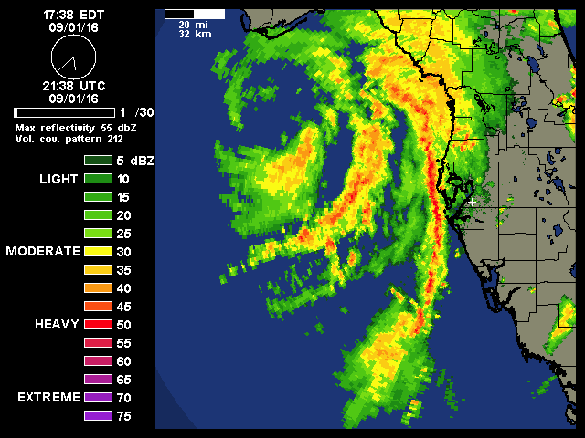
This will have more time over water if it keeps following the coast.
Last edited by JaxGator on Thu Sep 01, 2016 8:02 pm, edited 1 time in total.
2 likes   
The posts or stuff said are NOT an official forecast. Please look to the NHC and NWS for official forecasts and products.

Floyd-1999, Frances-2004, Jeanne-2004, Fay-2008, Beryl-2012, Debby-2012, Colin-2016, Hermine-2016, Julia-2016, Matthew-2016, Irma-2017, Elsa-2021, Idalia-2023, Debby-2024, Helene-2024.


Go Gators! Go Jags!

User avatar
Ntxw
Storm2k Moderator
Storm2k Moderator
Posts: 22785
Joined: Wed Oct 21, 2009 6:34 pm
Location: DFW, Texas

Re: ATL: HERMINE - Hurricane - Discussion

#8618 Postby Ntxw » Thu Sep 01, 2016 7:57 pm

She definitely may have RI'd or is doing so. ADT shot up pretty quick.

UW - CIMSS
ADVANCED DVORAK TECHNIQUE
ADT-Version 8.2.1
Tropical Cyclone Intensity Algorithm

----- Current Analysis -----
Date : 01 SEP 2016 Time : 234500 UTC
Lat : 29:09:02 N Lon : 84:50:41 W


CI# /Pressure/ Vmax
3.1 / 993.0mb/ 47.0kt


Final T# Adj T# Raw T#
3.1 4.2 5.9


While dvorak is subjective you have to raise an eyebrow. The Raw T #' is something you see with a major hurricane
1 likes   
The above post and any post by Ntxw is NOT an official forecast and should not be used as such. It is just the opinion of the poster and may or may not be backed by sound meteorological data. It is NOT endorsed by any professional institution including Storm2k. For official information, please refer to NWS products.

  Help support Storm2K!
Help Support Storm2K

jlauderdal
S2K Supporter
S2K Supporter
Posts: 7183
Joined: Wed May 19, 2004 5:46 am
Location: NE Fort Lauderdale
Contact:

Re: ATL: HERMINE - Hurricane - Discussion

#8619 Postby jlauderdal » Thu Sep 01, 2016 7:58 pm

chaser1 wrote:
jlauderdal wrote:
NDG wrote:I wouldn't doubt if the next nasty squall approaching west central FL has hurricane force winds in gusts.

http://i20.photobucket.com/albums/b245/ ... qpjlvf.gif
that inbound feeder band could cause some big power outages..get ready


BIG TIME! Was just thinking that. This is really gonna cause a lot of havoc with dock, marinas, sand dunes, ect. all up the coast this eve. , especially with the high tides ranging from 2:00 - 3:30am coming up

Friction with land should apin up tornados..will see..this band is intensifying too..bring in the woman and children folks
Last edited by Ntxw on Thu Sep 01, 2016 8:02 pm, edited 1 time in total.
Reason: Removed img tags
0 likes   

FLLurker32
Tropical Storm
Tropical Storm
Posts: 245
Joined: Mon Aug 29, 2016 10:31 am

Re: ATL: HERMINE - Hurricane - Discussion

#8620 Postby FLLurker32 » Thu Sep 01, 2016 7:59 pm

ZX12R wrote:In eastern Ocala. Constant rain but not heavy. No substantial winds to speak of. Just typical mediocre bands moving through. Just a report.


I'm in Belleview. We had some nasty ones go through a bit ago. There was a tornado warning in North lake and south marion with it. So even if it's not at you yet, they will be.
0 likes   
Heather


Return to “2016”

Who is online

Users browsing this forum: No registered users and 5 guests