ATL: HERMINE - Post-Tropical - Discussion

Moderator: S2k Moderators

Message
Author
User avatar
JaxGator
Category 2
Category 2
Posts: 780
Joined: Sun Jun 12, 2016 3:33 pm
Location: Jacksonville Florida

Re: ATL: HERMINE - Hurricane - Discussion

#8621 Postby JaxGator » Thu Sep 01, 2016 8:00 pm

jlauderdal wrote:
chaser1 wrote:
jlauderdal wrote:that inbound feeder band could cause some big power outages..get ready


BIG TIME! Was just thinking that. This is really gonna cause a lot of havoc with dock, marinas, sand dunes, ect. all up the coast this eve. , especially with the high tides ranging from 2:00 - 3:30am coming up

Friction with land should apin up tornados..will see..this band is intensifying too..bring in the woman and children folks


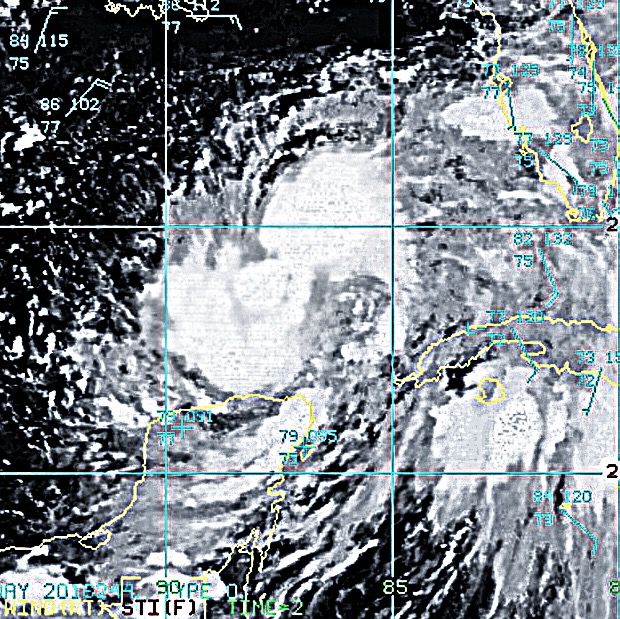
Looks like one of the radars might be down at the end of the loop. NWS Jax's radar shows that part of the hurricane still intact and getting stronger.
1 likes   
The posts or stuff said are NOT an official forecast. Please look to the NHC and NWS for official forecasts and products.

Floyd-1999, Frances-2004, Jeanne-2004, Fay-2008, Beryl-2012, Debby-2012, Colin-2016, Hermine-2016, Julia-2016, Matthew-2016, Irma-2017, Elsa-2021, Idalia-2023, Debby-2024, Helene-2024.


Go Gators! Go Jags!

BRweather
Category 1
Category 1
Posts: 331
Joined: Wed Aug 31, 2016 8:50 am
Location: Baton Rouge, LA

Re: ATL: HERMINE - Hurricane - Discussion

#8622 Postby BRweather » Thu Sep 01, 2016 8:01 pm

The automated station on the Tyndall Tower south of Apalachicola
recently reported a sustained wind of 61 mph (98 km/h) and a wind
gust of 76 mph (122 km/h) at an elevation of 115 ft (35 m).
1 likes   

Aric Dunn
Category 5
Category 5
Posts: 21238
Age: 42
Joined: Sun Sep 19, 2004 9:58 pm
Location: Ready for the Chase.
Contact:

Re: ATL: HERMINE - Hurricane - Discussion

#8623 Postby Aric Dunn » Thu Sep 01, 2016 8:02 pm

Cedar key is not having fun right now..
1 likes   
Note: If I make a post that is brief. Please refer back to previous posts for the analysis or reasoning. I do not re-write/qoute what my initial post said each time.
If there is nothing before... then just ask :)

Space & Atmospheric Physicist, Embry-Riddle Aeronautical University,
I believe the sky is falling...

User avatar
Weatherhorse
Tropical Low
Tropical Low
Posts: 22
Age: 50
Joined: Mon Jun 25, 2012 3:08 pm
Location: NW Marion County, FL

Re: ATL: HERMINE - Hurricane - Discussion

#8624 Postby Weatherhorse » Thu Sep 01, 2016 8:02 pm

Halfway between Ocala and Gainesville. No winds here yet, just steady rain for now.


FLLurker32 wrote:
ZX12R wrote:In eastern Ocala. Constant rain but not heavy. No substantial winds to speak of. Just typical mediocre bands moving through. Just a report.


I'm in Belleview. We had some nasty ones go through a bit ago. There was a tornado warning in North lake and south marion with it. So even if it's not at you yet, they will be.
1 likes   
"Prepare for the worst and hope for the best." Anon.
The posts in this forum are NOT official forecasts and should not be used as such. They are just the opinion of the poster and may or may not be backed by sound meteorological data. They are NOT endorsed by any professional institution or STORM2K. For official information, please refer to products from the NHC and NWS.

OntarioEggplant
Category 1
Category 1
Posts: 312
Joined: Sun Aug 07, 2016 11:16 am

Re: ATL: HERMINE - Hurricane - Discussion

#8625 Postby OntarioEggplant » Thu Sep 01, 2016 8:03 pm

Lightning going off in Cedar Key
1 likes   

Orlando
Tropical Storm
Tropical Storm
Posts: 119
Joined: Sat Aug 27, 2016 6:29 am

Re: ATL: HERMINE - Hurricane - Discussion

#8626 Postby Orlando » Thu Sep 01, 2016 8:03 pm

http://www.wctv.tv/livestream in Tallahassee is doing a live stream.
1 likes   

User avatar
chaser1
S2K Supporter
S2K Supporter
Posts: 5465
Age: 64
Joined: Sat Oct 15, 2005 5:59 pm
Location: Longwood, Fl

Re: ATL: HERMINE - Hurricane - Discussion

#8627 Postby chaser1 » Thu Sep 01, 2016 8:05 pm

For those of you all in the Carolina's and points north. My take is that the course northeast going through N. Fla, southern GA., S. Carolina and off the N. Carolina coast... will keep the core of the storm close enough to the coastline that allow it to continue to pull up a rich feed of moisture thus perhaps lessoning the weakening process until then reaching the Atlantic. At this time, it regains tropical characteristics - or not, but thats not really of great importance how barolclinic it may be considered to be. What is important will likely be the extensive low lying and coastal flooding that I think will take place primarily from the N.C. Outer banks northward to Long Island and E. Mass. Looks like the set up might keep a strong fetch pushing in high waves and wind on top of some level of storm surge impacted tides. There could be a respectible threat to coastal roads, low lying properties and significant beach erosion. Depending on the strength of the winds, I'm guessing substantial power outages might occur from exposed wires fallen from trees along its eventual path northeast from Fla. to N. Carolina. Be careful up there.
2 likes   
Andy D

(For official information, please refer to the NHC and NWS products.)

cdavis6287
Tropical Depression
Tropical Depression
Posts: 61
Joined: Mon Aug 22, 2016 11:37 pm

Re: ATL: HERMINE - Hurricane - Discussion

#8628 Postby cdavis6287 » Thu Sep 01, 2016 8:05 pm

Getting windy in the Saint Augustine area. Just checking in.
2 likes   

ZX12R
S2K Supporter
S2K Supporter
Posts: 82
Joined: Mon Aug 29, 2016 8:09 pm

Re: ATL: HERMINE - Hurricane - Discussion

#8629 Postby ZX12R » Thu Sep 01, 2016 8:05 pm

FLLurker32 wrote:
ZX12R wrote:In eastern Ocala. Constant rain but not heavy. No substantial winds to speak of. Just typical mediocre bands moving through. Just a report.


I'm in Belleview. We had some nasty ones go through a bit ago. There was a tornado warning in North lake and south marion with it. So even if it's not at you yet, they will be.


I believe it. I expect it to get worse than it has been. The first band to come through a couple hours ago, was more intense. Radar suggests the possibility of heavier bands coming through overnight.
1 likes   

User avatar
cycloneye
Admin
Admin
Posts: 145336
Age: 68
Joined: Thu Oct 10, 2002 10:54 am
Location: San Juan, Puerto Rico

Re: ATL: HERMINE - Advisories

#8630 Postby cycloneye » Thu Sep 01, 2016 8:05 pm

HURRICANE HERMINE TROPICAL CYCLONE UPDATE
NWS NATIONAL HURRICANE CENTER MIAMI FL AL092016
900 PM EDT THU SEP 01 2016

...9 PM EDT POSITION UPDATE...

The automated station on the Tyndall Tower south of Apalachicola
recently reported a sustained wind of 61 mph (98 km/h) and a wind
gust of 76 mph (122 km/h) at an elevation of 115 ft (35 m).


SUMMARY OF 900 PM EDT...0100 UTC...INFORMATION
----------------------------------------------
LOCATION...29.2N 84.6W
ABOUT 40 MI...65 KM SE OF APALACHICOLA FLORIDA
ABOUT 95 MI...155 KM W
0 likes   
Visit the Caribbean-Central America Weather Thread where you can find at first post web cams,radars
and observations from Caribbean basin members Click Here

User avatar
NDG
S2K Supporter
S2K Supporter
Posts: 15446
Joined: Sun Jul 09, 2006 10:14 pm
Location: Orlando, FL

Re: ATL: HERMINE - Hurricane - Discussion

#8631 Postby NDG » Thu Sep 01, 2016 8:05 pm

A strong vorticity went over WDW, now over Windermere in Orange County.
1 likes   

Aric Dunn
Category 5
Category 5
Posts: 21238
Age: 42
Joined: Sun Sep 19, 2004 9:58 pm
Location: Ready for the Chase.
Contact:

Re: ATL: HERMINE - Hurricane - Discussion

#8632 Postby Aric Dunn » Thu Sep 01, 2016 8:07 pm

it has slowed considerably and eyewall keep contracting and looking better every frame.
0 likes   
Note: If I make a post that is brief. Please refer back to previous posts for the analysis or reasoning. I do not re-write/qoute what my initial post said each time.
If there is nothing before... then just ask :)

Space & Atmospheric Physicist, Embry-Riddle Aeronautical University,
I believe the sky is falling...

tolakram
Admin
Admin
Posts: 20009
Age: 62
Joined: Sun Aug 27, 2006 8:23 pm
Location: Florence, KY (name is Mark)

Re: ATL: HERMINE - Hurricane - Discussion

#8633 Postby tolakram » Thu Sep 01, 2016 8:07 pm

Saved radar loop

Image
0 likes   
M a r k
- - - - -
Join us in chat: Storm2K Chatroom Invite. Android and IOS apps also available.

The posts in this forum are NOT official forecasts and should not be used as such. Posts are NOT endorsed by any professional institution or STORM2K.org. For official information and forecasts, please refer to NHC and NWS products.

BRweather
Category 1
Category 1
Posts: 331
Joined: Wed Aug 31, 2016 8:50 am
Location: Baton Rouge, LA

Re: ATL: HERMINE - Hurricane - Discussion

#8634 Postby BRweather » Thu Sep 01, 2016 8:08 pm

Cross City looks like the new point of most extreme conditions
0 likes   

SunnyThoughts
Category 5
Category 5
Posts: 2263
Joined: Wed Jul 09, 2003 12:42 pm
Location: Pensacola, Florida

Re: ATL: HERMINE - Hurricane - Discussion

#8635 Postby SunnyThoughts » Thu Sep 01, 2016 8:08 pm

...9 PM EDT position update...

The automated station on the Tyndall tower south of Apalachicola
recently reported a sustained wind of 61 mph (98 km/h) and a wind
gust of 76 mph (122 km/h) at an elevation of 115 ft (35 m).

Summary of 900 PM EDT...0100 UTC...information
----------------------------------------------
location...29.2n 84.6w
about 40 mi...65 km se of Apalachicola Florida
about 95 mi...155 km W of Cedar Key Florida
maximum sustained winds...80 mph...130 km/h
present movement...NNE or 30 degrees at 14 mph...22 km/h
minimum central pressure...983 mb...29.03 inches
1 likes   

OntarioEggplant
Category 1
Category 1
Posts: 312
Joined: Sun Aug 07, 2016 11:16 am

Re: ATL: HERMINE - Hurricane - Discussion

#8636 Postby OntarioEggplant » Thu Sep 01, 2016 8:08 pm

How much Hermine is strengthening and improving as it makes landfall is kind of scary
0 likes   

User avatar
drezee
S2K Supporter
S2K Supporter
Posts: 3664
Joined: Mon Jun 09, 2003 12:49 pm
Location: FL

Re: ATL: HERMINE - Hurricane - Discussion

#8637 Postby drezee » Thu Sep 01, 2016 8:08 pm

Please do not tell me that recon coms are lost right before a strengthening Hurricane comes ashore
0 likes   

User avatar
RazorTracks
Tropical Wave
Tropical Wave
Posts: 9
Age: 38
Joined: Sun Aug 28, 2016 4:59 pm
Location: Arkansas

Re: ATL: HERMINE - Hurricane - Discussion

#8638 Postby RazorTracks » Thu Sep 01, 2016 8:08 pm

Aric Dunn wrote:Cedar key is not having fun right now..


Looks like the storm surge is almost up to the top of the sea wall, which has already been mostly inundated with waves anyway. That area might not fare so well when all is said and done.

http://hurricanetrack.com/cam2.html
1 likes   
***NOT a professional, posts are opinion ONLY***

tolakram
Admin
Admin
Posts: 20009
Age: 62
Joined: Sun Aug 27, 2006 8:23 pm
Location: Florence, KY (name is Mark)

Re: ATL: HERMINE - Hurricane - Discussion

#8639 Postby tolakram » Thu Sep 01, 2016 8:09 pm

0 likes   
M a r k
- - - - -
Join us in chat: Storm2K Chatroom Invite. Android and IOS apps also available.

The posts in this forum are NOT official forecasts and should not be used as such. Posts are NOT endorsed by any professional institution or STORM2K.org. For official information and forecasts, please refer to NHC and NWS products.

User avatar
gatorcane
S2K Supporter
S2K Supporter
Posts: 23691
Age: 47
Joined: Sun Mar 13, 2005 3:54 pm
Location: Boca Raton, FL

Re: ATL: HERMINE - Hurricane - Discussion

#8640 Postby gatorcane » Thu Sep 01, 2016 8:09 pm

Radar presentation continues to improve...very impressive!
0 likes   


Return to “2016”

Who is online

Users browsing this forum: No registered users and 3 guests