ATL: HERMINE - Post-Tropical - Discussion

Moderator: S2k Moderators

Message
Author
User avatar
cycloneye
Admin
Admin
Posts: 145303
Age: 68
Joined: Thu Oct 10, 2002 10:54 am
Location: San Juan, Puerto Rico

Re: ATL: HERMINE - Advisories

#9021 Postby cycloneye » Fri Sep 02, 2016 7:02 am

BULLETIN
TROPICAL STORM HERMINE INTERMEDIATE ADVISORY NUMBER 20A
NWS NATIONAL HURRICANE CENTER MIAMI FL AL092016
800 AM EDT FRI SEP 02 2016

...HERMINE WEAKENING BUT WINDS INCREASING ALONG THE SOUTHEAST
COAST...
...STORM SURGE AND FLOODING RAINS CONTINUE...


SUMMARY OF 800 AM EDT...1200 UTC...INFORMATION
----------------------------------------------
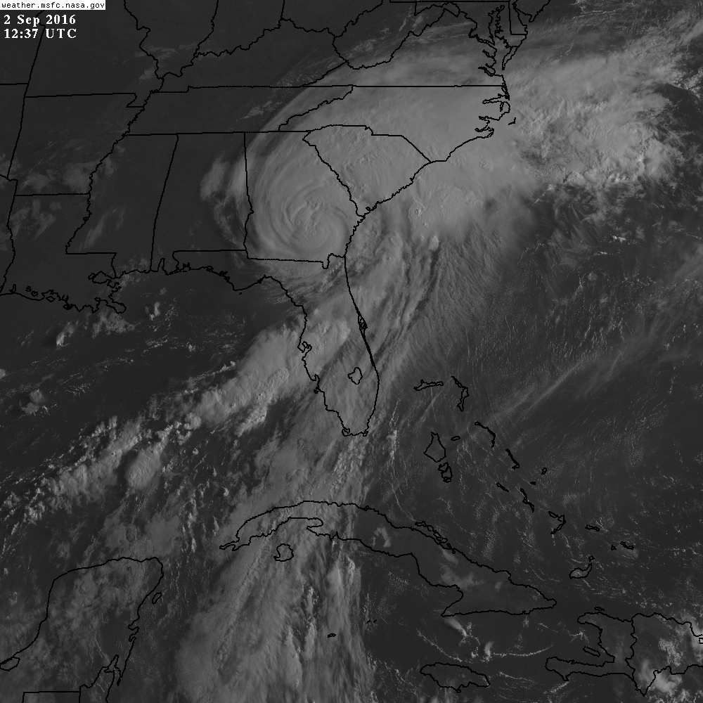
LOCATION...31.2N 82.9W
ABOUT 35 MI...60 KM NE OF VALDOSTA GEORGIA
ABOUT 120 MI...190 KM WSW OF SAVANNAH GEORGIA
MAXIMUM SUSTAINED WINDS...60 MPH...95 KM/H
PRESENT MOVEMENT...NNE OR 25 DEGREES AT 14 MPH...22 KM/H
MINIMUM CENTRAL PRESSURE...987 MB...29.21 INCHES


WATCHES AND WARNINGS
--------------------
CHANGES WITH THIS ADVISORY:

The Tropical Storm Warning has been discontinued west of the
Ochlockonee River.

SUMMARY OF WATCHES AND WARNINGS IN EFFECT:

A Tropical Storm Warning is in effect for...
* Englewood to Ochlockonee River
* Flagler/Volusia County line to Duck
* Pamlico and Albemarle Sounds

A Tropical Storm Watch is in effect for...
* North of Duck to Sandy Hook
* Chesapeake Bay from Smith Point southward
* Southern Delaware Bay

Interests elsewhere along the United States northeast coast should
monitor the progress of this system.

For storm information specific to your area, including possible
inland watches and warnings, please monitor products issued by your
local National Weather Service forecast office.


DISCUSSION AND 48-HOUR OUTLOOK
------------------------------
At 800 AM EDT (1200 UTC), the center of Tropical Storm Hermine was
located inland inland over southern Georgia near latitude 31.2
North, longitude 82.9 West. Hermine is moving toward the
north-northeast near 14 mph (22 km/h) and this motion is expected to
continue today and Saturday. On the forecast track, the center of
Hermine will continue to move across southeastern Georgia today,
move across the coastal Carolinas tonight and move offshore of the
North Carolina coast on Saturday.

Maximum sustained winds have decreased to near 60 mph (95 km/h) with
higher gusts. Additional weakening is forecast while the center of
Hermine remains over land. Some re-strengthening is expected after
the center moves offshore of the North Carolina coast on Saturday.

Tropical-storm-force winds extend outward up to 175 miles (280 km)
from the center. Recently reported wind gusts include 46 mph (74
km/h) at Brunswick, Georgia, and St. Augustine, Florida.

The estimated minimum central pressure is 987 mb (29.21 inches).


HAZARDS AFFECTING LAND
----------------------
WIND: Tropical storm conditions are expected to continue near the
center of Hermine this morning and spread northward within the
warning area along the Atlantic coast later today and tonight.
Winds in the tropical storm warning area along the Gulf coast of
Florida should gradually diminish today. Tropical storm conditions
are possible in the watch area on Saturday and Sunday.

STORM SURGE: The combination of a storm surge and the tide will
continue to cause normally dry areas near the coast to be flooded by
rising waters moving inland from the shoreline. Hazardous storm
surge will continue this morning along the Florida Gulf coast in
areas of onshore winds.

The water could reach the following heights above ground if the
peak surge occurs at the time of high tide...

Aucilla River to Bonita Beach...including Tampa Bay...1 to 3 feet
Florida-Georgia line to Tidewater of Virginia...1 to 3 feet

RAINFALL: Hermine is expected to produce storm total rainfall
accumulations of 5 to 10 inches over the southeastern United States
from northwest Florida through southern and eastern Georgia into
South Carolina and eastern North Carolina, with possible isolated
maximum amounts of 15 inches. These rains may cause life-threatening
floods and flash floods. Heavy rain could reach the coastal
Mid-Atlantic states from Virginia to New Jersey beginning early
Saturday.

TORNADOES: A few tornadoes are possible this morning across
northern Florida and southern Georgia. The tornado risk will spread
across the eastern Carolinas later today.


NEXT ADVISORY
-------------
Next complete advisory at 1100 AM EDT.

$$
Forecaster Brennan
0 likes   
Visit the Caribbean-Central America Weather Thread where you can find at first post web cams,radars
and observations from Caribbean basin members Click Here

SeGaBob

Re: ATL: HERMINE - Tropical Storm - Discussion

#9022 Postby SeGaBob » Fri Sep 02, 2016 7:14 am

Actually have 3 inches not 2. Judged it wrong from a distance. :)
1 likes   

User avatar
northjaxpro
S2K Supporter
S2K Supporter
Posts: 8900
Joined: Mon Sep 27, 2010 11:21 am
Location: Jacksonville, FL

Re: ATL: HERMINE - Tropical Storm - Discussion

#9023 Postby northjaxpro » Fri Sep 02, 2016 7:19 am

Local authorities in Taylor County are confirming Storm Surge of about 9 feet in Steinhatchee.

Also the number was revised in Tallahassee as they are now reporting over 60,000 without power. Still a lot of people. Tallahassee really caught the brunt of the northern eye wall of Hermine during landfall earlier this morning.
Last edited by northjaxpro on Fri Sep 02, 2016 7:29 am, edited 1 time in total.
2 likes   
NEVER, EVER SAY NEVER in the tropics and weather in general, and most importantly, with life itself!!

________________________________________________________________________________________

Fay 2008 Beryl 2012 Debby 2012 Colin 2016 Hermine 2016 Julia 2016 Matthew 2016 Irma 2017 Dorian 2019

User avatar
northjaxpro
S2K Supporter
S2K Supporter
Posts: 8900
Joined: Mon Sep 27, 2010 11:21 am
Location: Jacksonville, FL

Re: ATL: HERMINE - Tropical Storm - Discussion

#9024 Postby northjaxpro » Fri Sep 02, 2016 7:24 am

SeGaBob wrote:Actually have 3 inches not 2. Judged it wrong from a distance. :)


I am getting a feederband coming through now. This is the same one which produced the 69 mph gust down in Cecil Commerce, about 15-20 miles from me. I measured 42 mph wind gust a few moments ago in this band rotating through my locale.

This band will push my rain total likely over 3 inches as well for me here.
0 likes   
NEVER, EVER SAY NEVER in the tropics and weather in general, and most importantly, with life itself!!

________________________________________________________________________________________

Fay 2008 Beryl 2012 Debby 2012 Colin 2016 Hermine 2016 Julia 2016 Matthew 2016 Irma 2017 Dorian 2019

otowntiger
Category 5
Category 5
Posts: 1921
Joined: Tue Aug 31, 2004 7:06 pm

Re: ATL: HERMINE - Tropical Storm - Discussion

#9025 Postby otowntiger » Fri Sep 02, 2016 7:34 am

I was looking at the NOAA.GOV site for Tallahassee to see what their worst wind was and apparently they had some problems as the data is spotty and limited esp. around the time the weather was the worst there. Anybody have any data that indicates how bad Tally got it?

By the way we really didn't get anything here in downtown Orlando until this morning when that strong feeder band that was training off of the gulf thru Tampa finally swung a little this way but was not as strong. Moderate intermittent rain, gusts to 30ish. Fairly impressive considering the distance we are away from the storm and our inland locale.
1 likes   

User avatar
Happy Pelican
S2K Supporter
S2K Supporter
Posts: 119
Joined: Tue Sep 29, 2015 11:12 pm
Location: Pelican Island, Jersey Shore

Re: ATL: HERMINE - Tropical Storm - Discussion

#9026 Postby Happy Pelican » Fri Sep 02, 2016 7:41 am

Kazmit_ wrote:I hope everyone's okay down there, this storm is worrying me. The latest NHC track basically shows Hermine ramming Georgia, SC, NC, and then curving in towards the Northeastern states. I really don't want this to be a Sandy repeat.


I'm on the NJ barriers and you wouldn't even know a storm was coming. Local officials seem to be waiting to pull the trigger. I'll be spending the day filling gas cans, store and restocking my kit. I have Sandy ptsd and it's in overdrive. Spent the last two nights waking up from cold sweats and nightmares.
2 likes   

User avatar
Happy Pelican
S2K Supporter
S2K Supporter
Posts: 119
Joined: Tue Sep 29, 2015 11:12 pm
Location: Pelican Island, Jersey Shore

Re: ATL: HERMINE - Tropical Storm - Discussion

#9027 Postby Happy Pelican » Fri Sep 02, 2016 7:44 am

terstorm1012 wrote:
Kazmit_ wrote:I hope everyone's okay down there, this storm is worrying me. The latest NHC track basically shows Hermine ramming Georgia, SC, NC, and then curving in towards the Northeastern states. I really don't want this to be a Sandy repeat.


Not a negative tilt this time but one really strong Rex Block will keep this from moving back out to sea for some time. I think this will be much worse for the Jersey Shore than people might think. I'm glad the "Sandy" rule is in effect---whether Hermine gets all weird and hybrid or not, tropical watches and warnings will be issued. http://www.theweatherprediction.com/habyhints/178/ (link to Rex Block definition)


We just finished lifting our house 11 feet in the air from Sandy. The towns are packed with tourists and I'm floored they haven't even issued voluntary Evacs yet. Since Sandy, the flooding is crazy and some areas still don't have dunes. My gut is telling me this isn't going to end well.
1 likes   

User avatar
weathaguyry
Category 5
Category 5
Posts: 1272
Age: 22
Joined: Wed Jun 15, 2016 5:16 am
Location: Long Island, NY

Re: ATL: HERMINE - Tropical Storm - Discussion

#9028 Postby weathaguyry » Fri Sep 02, 2016 7:48 am

Happy Pelican wrote:
Kazmit_ wrote:I hope everyone's okay down there, this storm is worrying me. The latest NHC track basically shows Hermine ramming Georgia, SC, NC, and then curving in towards the Northeastern states. I really don't want this to be a Sandy repeat.


I'm on the NJ barriers and you wouldn't even know a storm was coming. Local officials seem to be waiting to pull the trigger. I'll be spending the day filling gas cans, store and restocking my kit. I have Sandy ptsd and it's in overdrive. Spent the last two nights waking up from cold sweats and nightmares.


I agree with you 100 percent, on Southern Long Island I asked my Aunt how she was preparing for Hermine, and she responded with "Hermine? Isn't that the storm that hit Florida?" I am petrified of what effects Hermine will have here, the new forecast cone shows it slowly drifting TOWARDS Long Island between Sunday and Wednesday, so people on Sunday will just think "oh yeah it'll be out of here by tomorrow" when really it will only get worse. I will provide storm coverage from Southern Nassau County in LI right where the beach meets the bay, until Tuesday when school starts again (unless of course school gets cancelled due to the effects of Hermine)
2 likes   
My posts are only my opinions and NOT official forecasts. For official forecasts, consult the National Hurricane Center or the National Weather Service.

Irene 11', Sandy 12', Fay 20’, Isaias 20’, Elsa 21’, Henri 21’, Ida 21’

LarryWx
S2K Supporter
S2K Supporter
Posts: 6305
Joined: Sun Sep 07, 2003 2:04 pm
Location: GA

Re: ATL: HERMINE - Tropical Storm - Discussion

#9029 Postby LarryWx » Fri Sep 02, 2016 7:49 am

Moderate to sometimes heavy rain fell over the last half hour or so adding to the previously measured 4" here in SAV with light to moderate rains falling now. Great news for the lawns!

The center appears to me to be on a heading that would get it closer to here than earlier expected just to our west. We were earlier getting gusts into the 40's easily and probably close to 50 a few times.
Last edited by LarryWx on Fri Sep 02, 2016 7:58 am, edited 4 times in total.
0 likes   
Personal Forecast Disclaimer:
The posts in this forum are NOT official forecasts and should not be used as such. They are just the opinion of the poster and may or may not be backed by sound meteorological data. They are NOT endorsed by any professional institution or storm2k.org. For official information, please refer to the NHC and NWS products.

User avatar
Happy Pelican
S2K Supporter
S2K Supporter
Posts: 119
Joined: Tue Sep 29, 2015 11:12 pm
Location: Pelican Island, Jersey Shore

Re: ATL: HERMINE - Tropical Storm - Discussion

#9030 Postby Happy Pelican » Fri Sep 02, 2016 7:54 am

weathaguyry wrote:
Happy Pelican wrote:
Kazmit_ wrote:I hope everyone's okay down there, this storm is worrying me. The latest NHC track basically shows Hermine ramming Georgia, SC, NC, and then curving in towards the Northeastern states. I really don't want this to be a Sandy repeat.


I'm on the NJ barriers and you wouldn't even know a storm was coming. Local officials seem to be waiting to pull the trigger. I'll be spending the day filling gas cans, store and restocking my kit. I have Sandy ptsd and it's in overdrive. Spent the last two nights waking up from cold sweats and nightmares.


I agree with you 100 percent, on Southern Long Island I asked my Aunt how she was preparing for Hermine, and she responded with "Hermine? Isn't that the storm that hit Florida?" I am petrified of what effects Hermine will have here, the new forecast cone shows it slowly drifting TOWARDS Long Island between Sunday and Wednesday, so people on Sunday will just think "oh yeah it'll be out of here by tomorrow" when really it will only get worse. I will provide storm coverage from Southern Nassau County in LI right where the beach meets the bay, until Tuesday when school starts again (unless of course school gets cancelled due to the effects of Hermine)


Exactly. It isn't going to take much to undo the Sandy recovery here.
0 likes   

User avatar
wxman57
Moderator-Pro Met
Moderator-Pro Met
Posts: 22978
Age: 67
Joined: Sat Jun 21, 2003 8:06 pm
Location: Houston, TX (southwest)

Re: ATL: HERMINE - Tropical Storm - Discussion

#9031 Postby wxman57 » Fri Sep 02, 2016 7:56 am

I think Hermine is going to stall about 120-150 miles offshore Maryland/Delaware Sun-Tue. It may well regain hurricane strength Sunday and maintain hurricane strength through Monday before finally beginning the transition to ET. As long as it remains offshore, I expect coastal locations from NY to MD will see steady 25-35 mph northerly winds but occasionally those winds will be up in the 40-45 mph range with higher gusts. Low-end TS winds possible for 48-60 hours before the center starts moving out to sea on Wednesday. Not a nice Labor Day weekend there.

Oh, and tides 4-7 feet above normal will cause tremendous beach erosion.
2 likes   

User avatar
NDG
S2K Supporter
S2K Supporter
Posts: 15446
Joined: Sun Jul 09, 2006 10:14 pm
Location: Orlando, FL

Re: ATL: HERMINE - Tropical Storm - Discussion

#9032 Postby NDG » Fri Sep 02, 2016 7:58 am

Is amazing how far from is Hermine drawing in moisture. It is a big system.

Image
0 likes   

lilac
S2K Supporter
S2K Supporter
Posts: 20
Joined: Fri Aug 19, 2011 7:38 am
Location: Long Island, NY

Re: ATL: HERMINE - Tropical Storm - Discussion

#9033 Postby lilac » Fri Sep 02, 2016 8:03 am

Thanks, wxman. I appreciate your predictions and the thought out information you are giving.
1 likes   

User avatar
northjaxpro
S2K Supporter
S2K Supporter
Posts: 8900
Joined: Mon Sep 27, 2010 11:21 am
Location: Jacksonville, FL

Re: ATL: HERMINE - Tropical Storm - Discussion

#9034 Postby northjaxpro » Fri Sep 02, 2016 8:06 am

NDG wrote:Is amazing how far from is Hermine drawing in moisture. It is a big system.

Image


Thank Heavens that Hermine waited late in the game getting her act together because if the right conditions had come to fruition in the Monday-Tuesday period of this week, I have no doubt that Hermine would have become a major hurricane in the Gulf of Mexico.
Last edited by northjaxpro on Fri Sep 02, 2016 8:09 am, edited 1 time in total.
1 likes   
NEVER, EVER SAY NEVER in the tropics and weather in general, and most importantly, with life itself!!

________________________________________________________________________________________

Fay 2008 Beryl 2012 Debby 2012 Colin 2016 Hermine 2016 Julia 2016 Matthew 2016 Irma 2017 Dorian 2019

xironman
S2K Supporter
S2K Supporter
Posts: 2522
Joined: Sun Jun 10, 2007 4:53 pm
Location: NoVA

Re: ATL: HERMINE - Tropical Storm - Discussion

#9035 Postby xironman » Fri Sep 02, 2016 8:08 am

Fifty miles off the coast or fifty miles inland will definitely impact how the Carolinas fair.
1 likes   

Nate-Gillson
Tropical Storm
Tropical Storm
Posts: 133
Age: 39
Joined: Sun Aug 22, 2004 8:27 pm
Location: Cedar Rapids, Iowa

Re: ATL: HERMINE - Tropical Storm - Discussion

#9036 Postby Nate-Gillson » Fri Sep 02, 2016 8:11 am

Not sure if this is on topic, but as Hermine made landfall with 80 mph winds last night, that's the winds that I experienced from the derecho on Monday June 30, 2014. Caused alot of damage in Cedar Rapids, Iowa along with nasty power outages (I was out of 7.5 hours). Cat 1 hurricanes are nothing to sneeze at.
3 likes   

User avatar
bg1
Category 1
Category 1
Posts: 409
Joined: Fri May 13, 2011 11:14 am
Location: near Santee, SC

Re: ATL: HERMINE - Tropical Storm - Discussion

#9037 Postby bg1 » Fri Sep 02, 2016 8:13 am

wxman57 wrote:I think Hermine is going to stall about 120-150 miles offshore Maryland/Delaware Sun-Tue. It may well regain hurricane strength Sunday and maintain hurricane strength through Monday before finally beginning the transition to ET. As long as it remains offshore, I expect coastal locations from NY to MD will see steady 25-35 mph northerly winds but occasionally those winds will be up in the 40-45 mph range with higher gusts. Low-end TS winds possible for 48-60 hours before the center starts moving out to sea on Wednesday. Not a nice Labor Day weekend there.

Oh, and tides 4-7 feet above normal will cause tremendous beach erosion.


Do you have rainfall estimates?
1 likes   

LarryWx
S2K Supporter
S2K Supporter
Posts: 6305
Joined: Sun Sep 07, 2003 2:04 pm
Location: GA

Re: ATL: HERMINE - Tropical Storm - Discussion

#9038 Postby LarryWx » Fri Sep 02, 2016 8:16 am

The NHC had this still moving NNE as of 8 AM. It has been moving more in a NE direction averaged out over the last 4 hours imo. Expecting increase in outages here in SAV as center gets to its closest approach in a few hours and causes more frequent and probably higher gusts. Moderate to heavy rain here now. Nearing 4.5" total now.
1 likes   
Personal Forecast Disclaimer:
The posts in this forum are NOT official forecasts and should not be used as such. They are just the opinion of the poster and may or may not be backed by sound meteorological data. They are NOT endorsed by any professional institution or storm2k.org. For official information, please refer to the NHC and NWS products.

WilmingtonSandbar
S2K Supporter
S2K Supporter
Posts: 505
Joined: Sun Aug 29, 2010 12:11 pm
Location: Southport, NC

Re: ATL: HERMINE - Tropical Storm - Discussion

#9039 Postby WilmingtonSandbar » Fri Sep 02, 2016 8:24 am

xironman wrote:Fifty miles off the coast or fifty miles inland will definitely impact how the Carolinas fair.


I just noted this exact thing in my local/personal update.
2 likes   
Diana X2 (look it up), Bertha, Fran, Bonnie, Floyd, Dennis, Charley, Ophelia, Ernesto, Irene, Matthew, And Florence

User avatar
mpic
S2K Supporter
S2K Supporter
Posts: 622
Joined: Thu Oct 20, 2005 11:24 am
Location: Splendora, TX

Re: ATL: HERMINE - Tropical Storm - Discussion

#9040 Postby mpic » Fri Sep 02, 2016 8:33 am

Would like some current updates from anyone in or near Augusta from those on the ground if possible
1 likes   
Alicia, Rita, Ike, Harvey and Beryl...moved to Splendora lol


Return to “2016”

Who is online

Users browsing this forum: No registered users and 5 guests