With a correlation coefficient of 0.82, I would not be trusting any of the models.
Ryan Maue @RyanMaue 2h2 hours ago
GFS and ECMWF 12z are in substantial disagreement at Day 5.
r = 0.82 anomalously low correlation for NHEMI. N America is a mess
Texas Fall-2016
Moderator: S2k Moderators
Forum rules

The posts in this forum are NOT official forecast and should not be used as such. They are just the opinion of the poster and may or may not be backed by sound meteorological data. They are NOT endorsed by any professional institution or STORM2K.
-
aggiecutter
- Category 5

- Posts: 1755
- Joined: Thu Oct 14, 2004 9:22 pm
- Location: Texarkana
Re: Texas Fall-2016
0 likes
-
weatherdude1108
- Category 5
- Posts: 4228
- Joined: Tue Dec 13, 2011 1:04 pm
- Location: Northwest Austin/Cedar Park, TX
Re: Texas Fall-2016
EWX's discussion:
164
FXUS64 KEWX 222001
AFDEWX
Area Forecast Discussion
National Weather Service Austin/San Antonio TX
301 PM CDT THU SEP 22 2016
.SHORT TERM (Tonight through Friday Night)...
A weak circulation off the Texas coast is coming onshore today
bringing convective activity into the Coastal Plains this
afternoon. This activity is expected to wane with the loss of
diurnal heating. Also...RAP analysis shows PWAT values decreasing
pretty steeply at the I-35 corridor which should prevent this
activity from getting too far west this evening.
A similar pattern will be in place tomorrow with slightly better
moisture across the eastern zones. This is in response to the
weakening upper level ridge over the eastern half of the state.
The gradual destabilization of the overall H5 pattern as the main
upper low to the northwest moves in, in conjunction with improved
deep layer moisture, should bring decent rain chances mostly east
of the I-35 corridor.
&&
.LONG TERM (Saturday through Thursday)...
The focus of the long term continues to be the prospect of heavy
rainfall potential late in the weekend. As advertised the past few
days...a deep low pressure system in the Pacific Northwest will
begin a translational and transformational period over the next 72
hours that will result in most of the state being under the gun
for heavy rainfall potential.
The main issue with the current model suite is the ongoing
disagreement in H5 pattern, strength, and dynamics. Beginning 00Z
Monday, deterministic GFS and ECMWF begin to diverge. This is
particularly complicating to the forecast as this also appears to
be the time in which all models begin generating significant QPF.
While the GFS produces a weaker cut-off low that exits to meet the
tropical system in the gulf of California, the ECMWF generates a
much deeper and broader low which retrogrades west back over
Southern California. And while both generate a strong cold front,
only the GFS aggressively pushes it through the CWA Monday, which
is contrast to this time yesterday, in which the ECMWF was much
more progressive.
From a QPF standpoint, the GFS run accumulation would certainly
raise eyebrows with a bullseye over the western CWA falling in a
12-24 hour time frame, however the ECMWF really keeps the majority
of the QPF north of the CWA and much more gradual in nature, over
the course of 24-48 hours. Of note is the ensemble member
consistency in the GEFS for QPF showing anomalous values, however
this is still just one model advertising such values, so until
other models begin showing something in the ballpark, will not
jump the gun and proceed with WPC`s gradual uptick in overall QPF
from yesterday. So as it stands this afternoon...three to five
inches of rain certainly looks possible between Sunday and
Tuesday...with the best potential for heavy rain being overnight
Sunday night into Monday morning. Figuring that 80-90 percent of
the total rainfall would fall in that time-frame, flash flood
impacts would be greatest during then as well.
Further discrepancies exist on the exit of this system...as ECMWF
holds on to PoPs throughout mid week due to Texas being under a
moist ridge pattern, yet the GFS is quite a bit drier.
0 likes
The preceding post is NOT an official forecast, and should not be used as such. It is only the opinion of the poster and may or may not be backed by sound meteorological data. It is NOT endorsed by any professional institution including storm2k.org. For Official Information please refer to the NHC and NWS products.
-
Brent
- S2K Supporter

- Posts: 38738
- Age: 37
- Joined: Sun May 16, 2004 10:30 pm
- Location: Tulsa Oklahoma
- Contact:
Re: Texas Fall-2016
FWD officially going highs in the 70s Monday and Tuesday at DFW... and barely low 80s beyond that.
Fall is coming guys.
Fall is coming guys.
0 likes
#neversummer
-
weatherdude1108
- Category 5
- Posts: 4228
- Joined: Tue Dec 13, 2011 1:04 pm
- Location: Northwest Austin/Cedar Park, TX
Re: Texas Fall-2016
Bob Rose:
Rain totals between Sunday morning and Tuesday morning have the potential to be quite high. Most model solutions are calling for 2-day totals in the range of 3-5 inches. Do note that some solutions are calling for isolated higher totals, especially across the western and northern Hill Country.
http://www.lcra.org/water/river-and-wea ... ather.aspx
1 likes
The preceding post is NOT an official forecast, and should not be used as such. It is only the opinion of the poster and may or may not be backed by sound meteorological data. It is NOT endorsed by any professional institution including storm2k.org. For Official Information please refer to the NHC and NWS products.

Re: Texas Fall-2016
Seems like it would be easier to wait till Saturday before taking a serious look at the short range forecast. It's to the point where I take anything beyond 3 days with a grain of salt.
Other than It's pretty much a sure bet that there will be rain and cooler temps next week, how much rain and how cool is anyone's guess.
Other than It's pretty much a sure bet that there will be rain and cooler temps next week, how much rain and how cool is anyone's guess.
0 likes
Resident Rain Miser
I am a weather hobbyist living 3.5 miles south of Downtown Austin and in no way or fashion should anything I say concerning forecasts be taken seriously. Please check your local NWS for accurate weather forecasting and conditions.
I am a weather hobbyist living 3.5 miles south of Downtown Austin and in no way or fashion should anything I say concerning forecasts be taken seriously. Please check your local NWS for accurate weather forecasting and conditions.
-
weatherdude1108
- Category 5
- Posts: 4228
- Joined: Tue Dec 13, 2011 1:04 pm
- Location: Northwest Austin/Cedar Park, TX
Re: Texas Fall-2016
JDawg512 wrote:Seems like it would be easier to wait till Saturday before taking a serious look at the short range forecast. It's to the point where I take anything beyond 3 days with a grain of salt.
Other than It's pretty much a sure bet that there will be rain and cooler temps next week, how much rain and how cool is anyone's guess.
True. Agreed.
0 likes
The preceding post is NOT an official forecast, and should not be used as such. It is only the opinion of the poster and may or may not be backed by sound meteorological data. It is NOT endorsed by any professional institution including storm2k.org. For Official Information please refer to the NHC and NWS products.


-
TheProfessor

- Professional-Met

- Posts: 3506
- Age: 29
- Joined: Tue Dec 03, 2013 10:56 am
- Location: Wichita, Kansas
Re: Texas Fall-2016
Brent wrote:Cat 5 in the Gulf again...
The Storm would actually be stronger than that I believe. From what I remember full resolution cuts off at 240 hours and at 240 hours the storm is already at 917 mb. (That Would be rapid weakening if a storm went from 917mb to 949 mb in 12 hours) The storm continues to strengthen after that so that would be a scary strong storm. Good thing it's outside of 240 hours.
0 likes
An alumnus of The Ohio State University.
Your local National Weather Service office is your best source for weather information.
Your local National Weather Service office is your best source for weather information.
-
TeamPlayersBlue

- Category 5
- Posts: 3530
- Joined: Tue Feb 02, 2010 1:44 am
- Location: Denver/Applewood, CO
Re: Texas Fall-2016
As JB said in twitter this morning, VERY hard to get a storm here in october with fronts starting to come into the state, which would eject them in the NE direction. At the same time, nothing is impossible if there is an upper level HP in the SE CONUS
0 likes
Personal Forecast Disclaimer:
The posts in this forum are NOT official forecast and should not be used as such. They are just the opinion of the poster and may or may not be backed by sound meteorological data. They are NOT endorsed by any professional institution or storm2k.org. For official information, please refer to the NHC and NWS products.
The posts in this forum are NOT official forecast and should not be used as such. They are just the opinion of the poster and may or may not be backed by sound meteorological data. They are NOT endorsed by any professional institution or storm2k.org. For official information, please refer to the NHC and NWS products.


Re: Texas Fall-2016
A hurricane is way too small (in the grand scheme of a numerical prediction) for a model to predict within 5 days no less 10+ plus. it's like trying to predict a thunderstorm cluster 300+ hours and having it in Houston precisely. The math is just outrageous  . What that can foresee (if other guidance is agreeing) is more favorable upper atmosphere down in the Carib where something might form if at all.
If the 300+ hours GFS was right this season that often Texas would've been hit by a few majors by now. There is some support for Carib development from the Euro however.
If the 300+ hours GFS was right this season that often Texas would've been hit by a few majors by now
0 likes
The above post and any post by Ntxw is NOT an official forecast and should not be used as such. It is just the opinion of the poster and may or may not be backed by sound meteorological data. It is NOT endorsed by any professional institution including Storm2k. For official information, please refer to NWS products.
Help support Storm2K!
-
TeamPlayersBlue
- Category 5
- Posts: 3530
- Joined: Tue Feb 02, 2010 1:44 am
- Location: Denver/Applewood, CO
Re: Texas Fall-2016
I agree, not worried at all since its only a wave right now. I always tell people that if it says its says its coming towards us now, thats good, likely not to happen.
0 likes
Personal Forecast Disclaimer:
The posts in this forum are NOT official forecast and should not be used as such. They are just the opinion of the poster and may or may not be backed by sound meteorological data. They are NOT endorsed by any professional institution or storm2k.org. For official information, please refer to the NHC and NWS products.
The posts in this forum are NOT official forecast and should not be used as such. They are just the opinion of the poster and may or may not be backed by sound meteorological data. They are NOT endorsed by any professional institution or storm2k.org. For official information, please refer to the NHC and NWS products.
-
Tireman4

- S2K Supporter
- Posts: 5903
- Age: 60
- Joined: Fri Jun 30, 2006 1:08 pm
- Location: Humble, Texas
- Contact:
Re: Texas Fall-2016
00
FXUS64 KHGX 231531
AFDHGX
Area Forecast Discussion
National Weather Service Houston/Galveston TX
1031 AM CDT Fri Sep 23 2016
.UPDATE...
Sufficient moisture continues to filter into the area, keeping rain
chances higher over the coastal waters and along the coast.
12Z soundings at CRP and LCH are keeping precipitable waters up
around 1.70 to 2.00 inches for this morning. Moisture will be in a
surplus for this afternoon and into the evening. A convective
temperature around 84 degrees should also be met today with the help
of daytime heating. Raised PoPs a bit to match current radar trends.
Onshore flow is helping to push showers developing over the coastal
waters over the coastal counties. A weak coastal trough has helped
aid storm development right along the coastline. This coastal
trough is acting as a boundary, where onshore winds are from the
southeast, and winds to the north of the boundary are from the east.
The change in wind direction along with a change in wind speed, is
acting as a zone of convergence. This area of convergence, will also
provide lift as indicated by both European the GFS omega fields over
the coastal counties early this afternoon. Cloud cover along with
the scattered showers will help to keep high temperatures a bit
cooler for this afternoon. Adjusted temperatures a degree down to
account for this.
Hathaway
&&
.PREV DISCUSSION... /ISSUED /
AVIATION...
MVFR to VFR ceilings in place across the Southeast Texas
terminals this morning are expected to transition to VFR by mid-
morning, with patchy IFR/MVFR fog at Conroe also expected to
dissipate around this time.
Beyond low ceilings and visibilities this morning, the main
aviation concern will be timing SHRA/possible TSRA near the
terminals. Scattered SHRA near Angleton and Galveston now will
expand inland with heating today. Convective temperatures are in
the low to mid 80s and expect shower coverage to increase near the
inland terminals 15-17Z as these temperatures are reached. Have
included TEMPO groups for SHRA midday with enhanced coverage
possible near the Houston terminals along a weak seabreeze. MVFR
ceilings and visibilities will be possible with stronger activity,
as well as gusty and variable winds. Expect SHRA/TSRA to end by
early evening with loss of heating, but another round of showers
is expected to spread inland towards the Houston terminals from
the Gulf early Saturday morning. Otherwise, southeast winds 10
knots or less are expected to prevail through the period.
Huffman
PREV DISCUSSION... /ISSUED /
DISCUSSION...
Mid-upper level ridging over the northern areas this morning with
moist low level flow from the Gulf across the southwestern area
and on into the Hill Country. Showers becoming more numerous over
the Gulf waters and expanding into the coastal counties up to
around I-10. The low level flow will drag in greater moisture
today and by mid morning expect scattered showers and isolated
thunderstorms to have spread well inland. Rich plume of low level
moisture from the central Gulf will flow into the region in
advance of longwave trough that will be advancing southeastward
today and Saturday before stalling. This keeps the moist
environment in place with strongest moisture advection focused
more toward the Hill Country/Central TX area. By late Sunday the
trough should be cutting off and drifting southwest...this may
spare SETX from the threat of very heavy rain but still not out of
the woods on heavy rain Sunday/Monday. PW 1-8-2.1" with
respectable instability but relatively light forcing today through
Saturday then only slightly more favorable forcing followed by a cold
front (timing is certainly in question on the front...will it
reach the area Monday as upper low sags southwest - or will it
stall just northwest of the area) Monday or Tuesday. Models have
been having a great deal of trouble with the trough`s evolution
and it continues...on a more positive note as the speed max moves
into the Pacific northwest today by 12z Saturday models should
have a much better sample on the upper air pattern and should
have a more reliable forecast. If the area is going to receive
heavy rainfall it should be in the Sunday through Monday time
frame as things stand now. Tuesday is a very low confidence
forecast - the front could be through the area and dry by
afternoon or stalled near the coast and wet. Eventually Wednesday
the surface ridging should be pushing south and drier air should
be intruding into the region with a corresponding lessening chance
for rainfall. Temperatures should continue to run above normal
through Sunday then dip back toward normal. Lows by Wednesday
morning could easily be in the 60s and possibly even around 60
(low chance but possible if ensemble guidance is to be believed).
45
MARINE...
South to southeast winds around 10-15 knots are expected to
persist through Sunday, but may approach caution criteria late
tonight and again Saturday night as a frontal system approaches
Texas. This onshore flow will continue to push deeper Gulf
moisture onto the Upper Texas Coast, resulting in periods of
showers and thunderstorms this weekend. There is still
considerable uncertainty regarding the timing of the cold front
as it moves into Texas on Sunday (and whether or not it will make
it off the Upper Texas Coast). With mid and upper level flow
continuing to look unfavorable for the front to make considerable
progress across Southeast Texas, expect onshore flow to continue
through Monday as the front stalls inland. However, winds look to
back to the east/northeast by late Monday as a weak surface low
develops over the southwest Gulf.
Increasing winds tonight and Saturday night combined with
elevated astronomical tides may result in tide levels approaching
2.7-3.0 feet above MLLW at high tide along the coast. Another
period of elevated tides is possible early to mid next week as
east to northeast winds become established.
Huffman
&&
.PRELIMINARY POINT TEMPS/POPS...
College Station (CLL) 94 76 92 75 89 / 40 10 50 20 60
Houston (IAH) 92 77 91 76 89 / 40 20 40 30 60
Galveston (GLS) 90 82 88 81 85 / 40 30 40 40 50
&&
.HGX WATCHES/WARNINGS/ADVISORIES...
TX...NONE.
GM...NONE.
&&
$$
0 likes
-
weatherdude1108
- Category 5
- Posts: 4228
- Joined: Tue Dec 13, 2011 1:04 pm
- Location: Northwest Austin/Cedar Park, TX
Re: Texas Fall-2016
POURING rain here at the office right now. It's a lone heavy shower it looks like on radar. Preview of things to come. 
0 likes
The preceding post is NOT an official forecast, and should not be used as such. It is only the opinion of the poster and may or may not be backed by sound meteorological data. It is NOT endorsed by any professional institution including storm2k.org. For Official Information please refer to the NHC and NWS products.
-
aggiecutter
- Category 5
- Posts: 1755
- Joined: Thu Oct 14, 2004 9:22 pm
- Location: Texarkana
Re: Texas Fall-2016
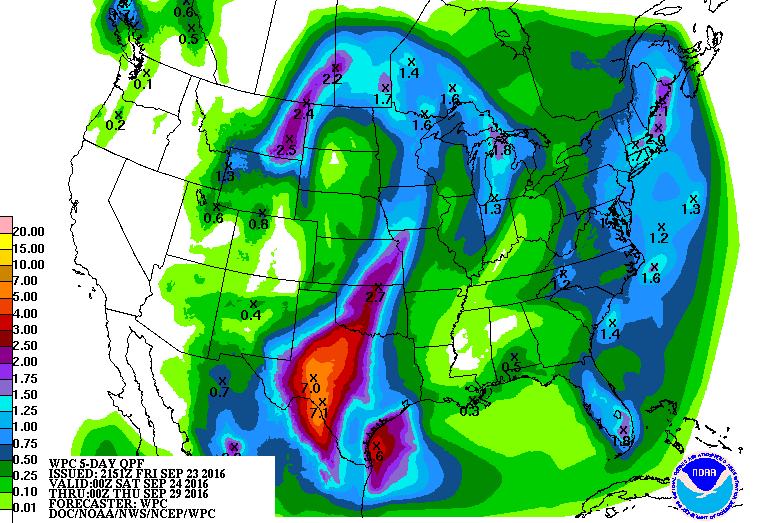
Today's model runs and the WPC don't think too much of the coming cool, and the axis of heavy rain is pushed to the west of I-35.

0 likes
-
aggiecutter
- Category 5
- Posts: 1755
- Joined: Thu Oct 14, 2004 9:22 pm
- Location: Texarkana


Re: Texas Fall-2016
No rain in this part of Austin today.. 
But an estimated 1-3 inches of rain in the coming days is not bad for my area... I'll take it.
It's really a good thing that the heaviest amounts are forecast stay west. A lot of that will fall over the upper Colorado River basin which is continuing to recover from the prolonged drought unlike the lower half. I haven't recently checked the reservoirs up there and honestly the Upper Colorado River Authority has a horrible website that rarely gets updated. From what I gather, the river is getting good rainfall drainage flow all the way up to the headwaters so that's great to hear.
0 likes
Resident Rain Miser
I am a weather hobbyist living 3.5 miles south of Downtown Austin and in no way or fashion should anything I say concerning forecasts be taken seriously. Please check your local NWS for accurate weather forecasting and conditions.
I am a weather hobbyist living 3.5 miles south of Downtown Austin and in no way or fashion should anything I say concerning forecasts be taken seriously. Please check your local NWS for accurate weather forecasting and conditions.
-
weatherdude1108
- Category 5
- Posts: 4228
- Joined: Tue Dec 13, 2011 1:04 pm
- Location: Northwest Austin/Cedar Park, TX
Re: Texas Fall-2016
JDawg512 wrote:No rain in this part of Austin today..
But an estimated 1-3 inches of rain in the coming days is not bad for my area... I'll take it.
It's really a good thing that the heaviest amounts are forecast stay west. A lot of that will fall over the upper Colorado River basin which is continuing to recover from the prolonged drought unlike the lower half. I haven't recently checked the reservoirs up there and honestly the Upper Colorado River Authority has a horrible website that rarely gets updated. From what I gather, the river is getting good rainfall drainage flow all the way up to the headwaters so that's great to hear.
I use this site, which shows current levels around the state. They need the multi-inch rains much worse west of here. Their lakes are mostly better, but still in the teens and 20 percent capacities mostly.
https://waterdatafortexas.org/reservoirs/statewide
0 likes
The preceding post is NOT an official forecast, and should not be used as such. It is only the opinion of the poster and may or may not be backed by sound meteorological data. It is NOT endorsed by any professional institution including storm2k.org. For Official Information please refer to the NHC and NWS products.
Re: Texas Fall-2016
weatherdude1108 wrote:JDawg512 wrote:No rain in this part of Austin today..
But an estimated 1-3 inches of rain in the coming days is not bad for my area... I'll take it.
It's really a good thing that the heaviest amounts are forecast stay west. A lot of that will fall over the upper Colorado River basin which is continuing to recover from the prolonged drought unlike the lower half. I haven't recently checked the reservoirs up there and honestly the Upper Colorado River Authority has a horrible website that rarely gets updated. From what I gather, the river is getting good rainfall drainage flow all the way up to the headwaters so that's great to hear.
I use this site, which shows current levels around the state. They need the multi-inch rains much worse west of here. Their lakes are mostly better, but still in the teens and 20 percent capacities mostly.
https://waterdatafortexas.org/reservoirs/statewide
Thanks for posting that link. Yea they still have a ways to go but at least the rain that they have seen over the last few weeks and this upcoming event should help but it's going to take time and a continuation of consistent rainfall. There's no guarantee that they will fill to their full capacities either but hopefully they can at least get to 50%.
0 likes
Resident Rain Miser
I am a weather hobbyist living 3.5 miles south of Downtown Austin and in no way or fashion should anything I say concerning forecasts be taken seriously. Please check your local NWS for accurate weather forecasting and conditions.
I am a weather hobbyist living 3.5 miles south of Downtown Austin and in no way or fashion should anything I say concerning forecasts be taken seriously. Please check your local NWS for accurate weather forecasting and conditions.
Re: Texas Fall-2016
Wichita Falls received a little over 3" of rain in an hour and still falling with the line to the NW of DFW. It will make it's way slowly through morning.
0 likes
The above post and any post by Ntxw is NOT an official forecast and should not be used as such. It is just the opinion of the poster and may or may not be backed by sound meteorological data. It is NOT endorsed by any professional institution including Storm2k. For official information, please refer to NWS products.
Help support Storm2K!
Help support Storm2K!
Re: Texas Fall-2016
Euro has a big ULL over the E Conus, will send a backdoor type front at the end of this week to reinforce fall air. Eastern half of the state will probably get into 50s for lows if you haven't already during early week. May be a dry frontal passage though but much drier crisp air. Northern half of the state will see coolish temps next few days after today's coool but humid air. Fall has arrived y'all
0 likes
The above post and any post by Ntxw is NOT an official forecast and should not be used as such. It is just the opinion of the poster and may or may not be backed by sound meteorological data. It is NOT endorsed by any professional institution including Storm2k. For official information, please refer to NWS products.
Help support Storm2K!
Help support Storm2K!
Return to “USA & Caribbean Weather”
Who is online
Users browsing this forum: Bing [Bot], mmmmsnouts and 72 guests