ATL: MATTHEW - Models
Moderator: S2k Moderators
-
Dylan

- Professional-Met

- Posts: 338
- Age: 31
- Joined: Mon May 31, 2010 9:50 am
- Location: New Orleans, LA
Re: ATL: INVEST 97L - Models
The westward trend in the model guidance today signals that the 11 year Major Hurricane Drought in the United States is under serious jeopardy.
0 likes
Georges('98), Allison('01), Isidore('02), Lili('02), Frances('04) Ivan('04), Cindy('05), Katrina('05), Rita('05), Gustav('08), Isaac('12), Matthew('16), Harvey('17), Irma('17), Nate ('17), Ida ('21).
-
SeGaBob
Re: ATL: INVEST 97L - Models
Dylan wrote:The westward trend in the model guidance today signals that the 11 year Major Hurricane Drought in the United States is under serious jeopardy.
I wouldn't go that far just yet...
0 likes
-
Dylan
- Professional-Met
- Posts: 338
- Age: 31
- Joined: Mon May 31, 2010 9:50 am
- Location: New Orleans, LA
Re: ATL: INVEST 97L - Models
SeGaBob wrote:Dylan wrote:The westward trend in the model guidance today signals that the 11 year Major Hurricane Drought in the United States is under serious jeopardy.
I wouldn't go that far just yet...
Why not? The synoptic pattern is dangerous with a classic ridge over troubled waters scenario.
The path out to sea shown by the MU and GEM has closed, and both models are caving into the ECMWF. At the very least, its a threat to the Lesser and Greater Antilles, and according to the latest guidance a serious threat to the Bahamas & United States. Nobody is out of the woods.
0 likes
Georges('98), Allison('01), Isidore('02), Lili('02), Frances('04) Ivan('04), Cindy('05), Katrina('05), Rita('05), Gustav('08), Isaac('12), Matthew('16), Harvey('17), Irma('17), Nate ('17), Ida ('21).
-
TimeZone
Re: ATL: INVEST 97L - Models
A major Hurricane making it all the way up to NE, in October? Weird. I don't buy it.
0 likes
-
stormreader
Re: ATL: INVEST 97L - Models
Bocadude85 wrote:WeatherEmperor wrote:Bocadude85 wrote:The 240 hour position from the 12Z Euro to the 0Z GFS is about 1500 miles.
Which is why in my opinion whichever ends up being wrong will suffer an all time epic bust. Just my opinion.
Sent from my iPhone 6 using Tapatalk
I agree. One of these models is going to be wrong in a big way. I do however think the west shifts will be coming to an end. I think the final outcome will be a hit on eastern/central Cuba and then the central Bahama islands and after that I am leaning out to sea.
I don't know Boca. I'm thinking the GFS busts. Let's watch to see next Euro, bet it continues and even strengthens the West trend. People talk about the move right, the recurve, that so often happens. It's true. But when a "right or recurve" forecast goes bust, it really goes bust! If the GFS Atlantic storm never happens, then this could be a GOM storm. And I mean Northern Gulf Coast. Without an Atkantic pick up it may very well go much further west than many here believe. A Yucatan Channel-GOM Storm in early Oct is by no means out of the question.
0 likes
-
Dylan
- Professional-Met
- Posts: 338
- Age: 31
- Joined: Mon May 31, 2010 9:50 am
- Location: New Orleans, LA
Re: ATL: INVEST 97L - Models
TimeZone wrote:A major Hurricane making it all the way up to NE, in October? Weird. I don't buy it.
Big difference between early October and late October. Look back at history, New England isn't immune to deadly hurricanes in October.
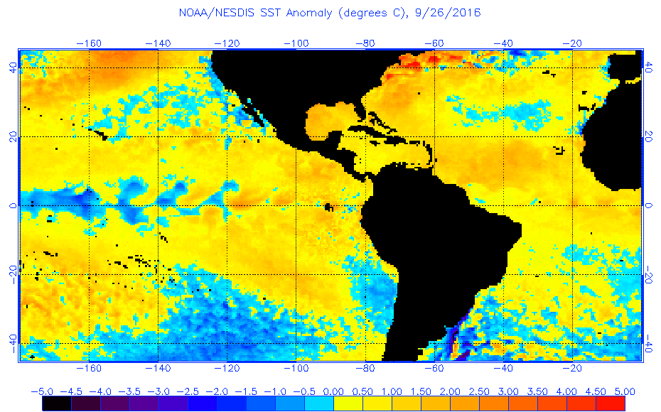
On top of that, record breaking SSTA's along the Eastern Seaboard should be cause for concern.
0 likes
Georges('98), Allison('01), Isidore('02), Lili('02), Frances('04) Ivan('04), Cindy('05), Katrina('05), Rita('05), Gustav('08), Isaac('12), Matthew('16), Harvey('17), Irma('17), Nate ('17), Ida ('21).
Re: ATL: INVEST 97L - Models
TimeZone wrote:A major Hurricane making it all the way up to NE, in October? Weird. I don't buy it.
I believe the worst New England hurricane ever in the 1600s occurred in October. Second worst (Sandy) also occurred in October, late October in fact. Makes sense as it would need a very strong trough to send it into New England at a rapid speed
1 likes
-
Dylan
- Professional-Met
- Posts: 338
- Age: 31
- Joined: Mon May 31, 2010 9:50 am
- Location: New Orleans, LA
Re: ATL: INVEST 97L - Models
Alyono wrote:TimeZone wrote:A major Hurricane making it all the way up to NE, in October? Weird. I don't buy it.
I believe the worst New England hurricane ever in the 1600s occurred in October. Second worst (Sandy) also occurred in October, late October in fact. Makes sense as it would need a very strong trough to send it into New England at a rapid speed
Actually, the Great Colonial Hurricane of 1635 came in a similar trajectory & strengths as the MU is showing, according to re-analysis.

0 likes
Georges('98), Allison('01), Isidore('02), Lili('02), Frances('04) Ivan('04), Cindy('05), Katrina('05), Rita('05), Gustav('08), Isaac('12), Matthew('16), Harvey('17), Irma('17), Nate ('17), Ida ('21).
-
USTropics
- Professional-Met
- Posts: 2738
- Joined: Sun Aug 12, 2007 3:45 am
- Location: Florida State University
Re: ATL: INVEST 97L - Models
GFS ensembles sticking with the EC recurve, closer to the coast this run though:
00z:

18z:

00z:
18z:
0 likes
Re: ATL: INVEST 97L - Models
Dylan wrote:SeGaBob wrote:Dylan wrote:The westward trend in the model guidance today signals that the 11 year Major Hurricane Drought in the United States is under serious jeopardy.
I wouldn't go that far just yet...
Why not? The synoptic pattern is dangerous with a classic ridge over troubled waters scenario.
The path out to sea shown by the MU and GEM has closed, and both models are caving into the ECMWF. At the very least, its a threat to the Lesser and Greater Antilles, and according to the latest guidance a serious threat to the Bahamas & United States. Nobody is out of the woods.
Well for starters we need a major hurricane...and that's been a tall order in recent years. we may get there but as of now we don't even have a TS yet. beyond that we need to get this to the US at that intensity and that's been a really tall order, hence the current record. I'm guessing the range of majors is rather limited in October for US shores... I don't know if we've had one landfall north of Hazel...and this would have to trend quite a bit to the west to threaten US shores south of there. I'm willing to revisit the issue when we have an eye but as of now I'd bet heavily on that record remaining intact.
0 likes
-
Dylan
- Professional-Met
- Posts: 338
- Age: 31
- Joined: Mon May 31, 2010 9:50 am
- Location: New Orleans, LA
Re: ATL: INVEST 97L - Models
psyclone wrote:Dylan wrote:SeGaBob wrote:
I wouldn't go that far just yet...
Why not? The synoptic pattern is dangerous with a classic ridge over troubled waters scenario.
The path out to sea shown by the MU and GEM has closed, and both models are caving into the ECMWF. At the very least, its a threat to the Lesser and Greater Antilles, and according to the latest guidance a serious threat to the Bahamas & United States. Nobody is out of the woods.
Well for starters we need a major hurricane...and that's been a tall order in recent years. we may get there but as of now we don't even have a TS yet. beyond that we need to get this to the US at that intensity and that's been a really tall order, hence the current record. I'm guessing the range of majors is rather limited in October for US shores... I don't know if we've had one landfall north of Hazel...and this would have to trend quite a bit to the west to threaten US shores south of there. I'm willing to revisit the issue when we have an eye but as of now I'd bet heavily on that record remaining intact.
I'm not getting into an argument over hypotheticals. Meteorology is a science, and I try my best to back up my statements with data, which I've done. My statement was that based on modeling, current conditions, and other events that have happened in the past, I think the 11 year drought is in jeopardy. Nothing crazy about that considering the ECMWF and MU have shown a major hurricane developing in the Caribbean for multiple days in a row now.
0 likes
Georges('98), Allison('01), Isidore('02), Lili('02), Frances('04) Ivan('04), Cindy('05), Katrina('05), Rita('05), Gustav('08), Isaac('12), Matthew('16), Harvey('17), Irma('17), Nate ('17), Ida ('21).
-
SeGaBob
Re: ATL: INVEST 97L - Models
Not long before the Euro...let's see what it shows.
It's running now actually.
It's running now actually.
0 likes
-
Bocadude85

- Category 5

- Posts: 2991
- Age: 39
- Joined: Mon Apr 18, 2005 2:20 pm
- Location: Honolulu,Hi
Re: ATL: INVEST 97L - Models
0Z GFDL has a major hurricane at 19N/80W after slamming Jamaica.
http://www.tropicaltidbits.com/analysis/models/?model=gfdl®ion=97L&pkg=mslp_wind&runtime=2016092700&fh=0&xpos=0&ypos=0
http://www.tropicaltidbits.com/analysis/models/?model=gfdl®ion=97L&pkg=mslp_wind&runtime=2016092700&fh=0&xpos=0&ypos=0
0 likes
-
tarheelprogrammer

- S2K Supporter

- Posts: 1793
- Joined: Mon Mar 28, 2016 9:25 pm
- Location: Raleigh, NC area (Garner, NC)
Re: ATL: INVEST 97L - Models
It seems the models are trending toward more of a due north movement out of the Caribbean. If the storm does turn north the key to whether it hits the US may be how far west it can go in the Caribbean. ECMWF tonight could be telling as to what trend may develop in the models. Who knows though.
0 likes
My posts are not official forecasts. They are just my opinion and may or may not be backed by sound meteorological data. They are NOT endorsed by any professional institution or storm2k.org. For official information, please refer to the NHC and NWS products.
-
Bocadude85
- Category 5
- Posts: 2991
- Age: 39
- Joined: Mon Apr 18, 2005 2:20 pm
- Location: Honolulu,Hi
Re: ATL: INVEST 97L - Models
Pretty big west shift on the 0Z HWRF when compared to the 18Z
http://www.tropicaltidbits.com/analysis/models/?model=hwrf®ion=97L&pkg=mslp_wind&runtime=2016092700&fh=126&xpos=0&ypos=0
http://www.tropicaltidbits.com/analysis/models/?model=hwrf®ion=97L&pkg=mslp_wind&runtime=2016092700&fh=126&xpos=0&ypos=0
0 likes

Re: ATL: INVEST 97L - Models
I'll say this. I large fairly low latitude system, minus the large atmospheric influence of a significant short wave digging south over the Eastern CONUS, could very well end up tracking a good deal further west. If we see the EURO shift westward in its 0Z run, then expect the GFS to soon follow. I could easily see the N. Gulf "in-play" by the time it's all said and done. Heck, I'm not fully convinced this storm even leaves the Caribbean.
0 likes
Andy D
(For official information, please refer to the NHC and NWS products.)
(For official information, please refer to the NHC and NWS products.)
-
USTropics
- Professional-Met
- Posts: 2738
- Joined: Sun Aug 12, 2007 3:45 am
- Location: Florida State University
Re: ATL: INVEST 97L - Models
Through 48 hours on the 00z ECMWF, looks like center location may be forming more to the NW this run:

0 likes
Re: ATL: INVEST 97L - Models
I saw that, but on each of the prior runs the EURO then bends the track south of due West. In fact, just looked at the EURO 500 MB anomalies and seeing BIG pressure rises north and west. Heck, we might just see a nose dive south lol?
0 likes
Andy D
(For official information, please refer to the NHC and NWS products.)
(For official information, please refer to the NHC and NWS products.)
Re: ATL: INVEST 97L - Models
SeGaBob wrote:Next frame or 2 should make the turn.
1 likes
Andy D
(For official information, please refer to the NHC and NWS products.)
(For official information, please refer to the NHC and NWS products.)
Who is online
Users browsing this forum: No registered users and 28 guests