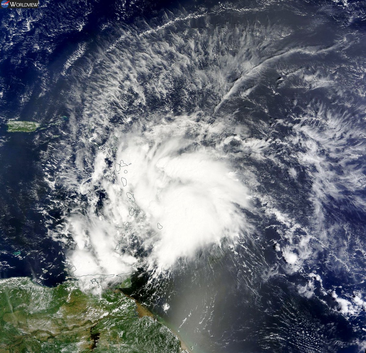
ATL: MATTHEW - Post-Tropical - Discussion

Moderator: S2k Moderators

Message
Author
User avatar
Hurricaneman
Category 5
Category 5
Posts: 7351
Age: 45
Joined: Tue Aug 31, 2004 3:24 pm
Location: central florida

Re: ATL: MATTHEW - Tropical Storm - Discussion

#941 Postby Hurricaneman » Wed Sep 28, 2016 3:43 pm

johngaltfla wrote:
JaxGator wrote:Stu Ostro ‏@StuOstro · 1h1 hour ago

Hi-res MODIS satellite image of #Matthew, a classic-looking potent Caribbean tropical storm

https://pbs.twimg.com/media/CtdprSKWAAAatdS.jpg


Beautiful outflow. He's in position to intensify rapidly...good looking storm.


Not much convection on the west side but once that happens this could deepen quite a bit
0 likes   

User avatar
cycloneye
Admin
Admin
Posts: 145360
Age: 68
Joined: Thu Oct 10, 2002 10:54 am
Location: San Juan, Puerto Rico

Re: ATL: MATTHEW - Tropical Storm - Discussion

#942 Postby cycloneye » Wed Sep 28, 2016 3:44 pm

BULLETIN
TROPICAL STORM MATTHEW ADVISORY NUMBER 2
NWS NATIONAL HURRICANE CENTER MIAMI FL AL142016
500 PM AST WED SEP 28 2016

...CENTER OF MATTHEW MOVING INTO THE EASTERN CARIBBEAN SEA...
...TROPICAL STORM CONDITIONS CONTINUE OVER PORTIONS OF THE LESSER
ANTILLES...

SUMMARY OF 500 PM AST...2100 UTC...INFORMATION
----------------------------------------------
LOCATION...13.8N 62.0W
ABOUT 65 MI...110 KM W OF ST. LUCIA
ABOUT 480 MI...775 KM ENE OF CURACAO
MAXIMUM SUSTAINED WINDS...60 MPH...95 KM/H
PRESENT MOVEMENT...W OR 280 DEGREES AT 18 MPH...30 KM/H
MINIMUM CENTRAL PRESSURE...1008 MB...29.77 INCHES
0 likes   
Visit the Caribbean-Central America Weather Thread where you can find at first post web cams,radars
and observations from Caribbean basin members Click Here

User avatar
northjaxpro
S2K Supporter
S2K Supporter
Posts: 8900
Joined: Mon Sep 27, 2010 11:21 am
Location: Jacksonville, FL

Re: ATL: MATTHEW - Tropical Storm - Discussion

#943 Postby northjaxpro » Wed Sep 28, 2016 3:46 pm

I posted yesterday and today about this complex pattern being among the most difficult concerning the evelotion with regrads of the projections of track that I have seen in quite some time. It is a very challenging forecast with Matthew in the days to come.
Last edited by northjaxpro on Wed Sep 28, 2016 3:48 pm, edited 1 time in total.
2 likes   
NEVER, EVER SAY NEVER in the tropics and weather in general, and most importantly, with life itself!!

________________________________________________________________________________________

Fay 2008 Beryl 2012 Debby 2012 Colin 2016 Hermine 2016 Julia 2016 Matthew 2016 Irma 2017 Dorian 2019

User avatar
cycloneye
Admin
Admin
Posts: 145360
Age: 68
Joined: Thu Oct 10, 2002 10:54 am
Location: San Juan, Puerto Rico

Re: ATL: MATTHEW - Tropical Storm - Discussion

#944 Postby cycloneye » Wed Sep 28, 2016 3:48 pm

Excerpt from 5 PM discussion.

The tropical cyclone should move generally westward
during the next 2 to 3 days to the south of a strong deep-layer
ridge over the western Atlantic. The new NHC track forecast has
been nudged northward through 72 hours, to be closer to the new
model consensus. After day 3, Matthew is expected to turn
northwestward as it nears the western portion of the ridge. The
overall track envelope has shifted slightly eastward at days 4 and
5, and the NHC track has been adjusted accordingly. It should
be noted that are still significant differences among the models in
how soon and how sharply Matthew turns northwestward and northward
late in the forecast period. Users are reminded that the average
NHC track errors at days 4 and 5 are on the order of 180 and 240
miles, respectively.
0 likes   
Visit the Caribbean-Central America Weather Thread where you can find at first post web cams,radars
and observations from Caribbean basin members Click Here

User avatar
johngaltfla
Category 5
Category 5
Posts: 2069
Joined: Sun Jul 10, 2005 9:17 pm
Location: Sarasota County, FL
Contact:

Re: ATL: MATTHEW - Tropical Storm - Discussion

#945 Postby johngaltfla » Wed Sep 28, 2016 3:48 pm

northjaxpro wrote:I posted yesterday and today about this complex pattern being among the most difficult concerning the evelotion with regrads of the projrctions of track that I have seen in quite some time. It is a very challenging forecast with Matthew in the days to come.


I don't envy the pros on this one. Way too many variables and a tough time of year to project too far forward. Man are you guys going to be in overdrive working on this storm...(thanks for all you pros post here also, it's an education every day, every year since I joined)
0 likes   

User avatar
Kazmit
Category 5
Category 5
Posts: 2124
Age: 22
Joined: Mon Jul 25, 2016 8:49 am
Location: Williamsburg, VA / Bermuda

Re: ATL: MATTHEW - Tropical Storm - Discussion

#946 Postby Kazmit » Wed Sep 28, 2016 3:48 pm

I think the max intensity predicted by the NHC is far too conservative. They only call for a peak of 105mph, only a Cat 2. I predict to see a peak of somewhere in between a high-end Cat 3, and high-end Cat 4.
0 likes   
Igor 2010, Sandy 2012, Fay 2014, Gonzalo 2014, Joaquin 2015, Nicole 2016, Humberto 2019

I am only a tropical weather enthusiast. My predictions are not official and may or may not be backed by sound meteorological data. For official information, please refer to the NHC and NWS products.

User avatar
Steve
S2K Supporter
S2K Supporter
Posts: 9621
Joined: Sat Apr 05, 2003 11:41 pm
Location: Not a state-caster

Re: ATL: MATTHEW - Tropical Storm - Discussion

#947 Postby Steve » Wed Sep 28, 2016 3:51 pm

johngaltfla wrote: This is just a computer projection so my interpretation is pressure gradient, not a direct/indirect hit from the storm as far as I can tell. Still it is an interesting possibility, plus many of the old timers remember Donna so they don't like the potential for any storm turning north near the spine of Florida.


Let me keep this clean as possible. But assuming that we all know the root of the word peninsula, wouldn't the urethra of Florida be a better term than spine?

Sorry.
3 likes   

User avatar
La Sirena
Category 1
Category 1
Posts: 307
Joined: Sun Aug 21, 2016 4:02 pm
Location: Formerly of the Keys, back home in East TN

Re: ATL: MATTHEW - Tropical Storm - Discussion

#948 Postby La Sirena » Wed Sep 28, 2016 3:51 pm

tarheelprogrammer wrote:The stronger Matthew gets early on the more likely the system is to turn north quicker correct?

I believe it's the faster it moves regarding that north turn....hence the GFS. Slower it moves the more west it's anticipated to go before turning north according to the Euro. Think I got that right lol.
The posts in this forum are NOT official forecasts and should not be used as such. They are just the opinion of the poster and may or may not be backed by sound meteorological data. They are NOT endorsed by any professional institution or STORM2K. For official information, please refer to products from the NHC and NWS.


I'm directionally challenged when typing today lol.
Last edited by La Sirena on Wed Sep 28, 2016 3:54 pm, edited 1 time in total.
1 likes   
The posts in this forum are NOT official forecasts and should not be used as such. They are just the opinion of the poster and may or may not be backed by sound meteorological data. They are NOT endorsed by any professional institution or STORM2K. For official information, please refer to products from the NHC and NWS.

User avatar
JaxGator
Category 2
Category 2
Posts: 780
Joined: Sun Jun 12, 2016 3:33 pm
Location: Jacksonville Florida

Re: ATL: MATTHEW - Tropical Storm - Discussion

#949 Postby JaxGator » Wed Sep 28, 2016 3:53 pm

The latest NHC advisory has Matthew's forward speed down to 18 mph. Still fast but it's slowing down.
0 likes   
The posts or stuff said are NOT an official forecast. Please look to the NHC and NWS for official forecasts and products.

Floyd-1999, Frances-2004, Jeanne-2004, Fay-2008, Beryl-2012, Debby-2012, Colin-2016, Hermine-2016, Julia-2016, Matthew-2016, Irma-2017, Elsa-2021, Idalia-2023, Debby-2024, Helene-2024.


Go Gators! Go Jags!

User avatar
wxman57
Moderator-Pro Met
Moderator-Pro Met
Posts: 22979
Age: 67
Joined: Sat Jun 21, 2003 8:06 pm
Location: Houston, TX (southwest)

Re: ATL: MATTHEW - Tropical Storm - Discussion

#950 Postby wxman57 » Wed Sep 28, 2016 3:54 pm

johngaltfla wrote:I don't envy the pros on this one. Way too many variables and a tough time of year to project too far forward. Man are you guys going to be in overdrive working on this storm...(thanks for all you pros post here also, it's an education every day, every year since I joined)


Wish I didn't have to issue 7-day forecasts. We're following the EC more than the GFS. I wish it would get carried off to the north more quickly, but I'm not counting on it. With it moving so slowly I may not have to work this weekend.
2 likes   

User avatar
northjaxpro
S2K Supporter
S2K Supporter
Posts: 8900
Joined: Mon Sep 27, 2010 11:21 am
Location: Jacksonville, FL

Re: ATL: MATTHEW - Tropical Storm - Discussion

#951 Postby northjaxpro » Wed Sep 28, 2016 3:56 pm

Kazmit_ wrote:I think the max intensity predicted by the NHC is far too conservative. They only call for a peak of 105mph, only a Cat 2. I predict to see a peak of somewhere in between a high-end Cat 3, and high-end Cat 4.


I agree. I also thnk Matthew could reach at least Category 4 intensity down the road, esppecilly while in the Caribbean or either in the vicinity of The Bahamas.
0 likes   
NEVER, EVER SAY NEVER in the tropics and weather in general, and most importantly, with life itself!!

________________________________________________________________________________________

Fay 2008 Beryl 2012 Debby 2012 Colin 2016 Hermine 2016 Julia 2016 Matthew 2016 Irma 2017 Dorian 2019

User avatar
La Sirena
Category 1
Category 1
Posts: 307
Joined: Sun Aug 21, 2016 4:02 pm
Location: Formerly of the Keys, back home in East TN

Re: ATL: MATTHEW - Tropical Storm - Discussion

#952 Postby La Sirena » Wed Sep 28, 2016 3:59 pm

JaxGator wrote:The latest NHC advisory has Matthew's forward speed down to 18 mph. Still fast but it's slowing down.

Well, if it's starting to slow down then that would put it more in line with the Euro, right? They were anticipating a slower moving system traveling further westward.
0 likes   
The posts in this forum are NOT official forecasts and should not be used as such. They are just the opinion of the poster and may or may not be backed by sound meteorological data. They are NOT endorsed by any professional institution or STORM2K. For official information, please refer to products from the NHC and NWS.

User avatar
northjaxpro
S2K Supporter
S2K Supporter
Posts: 8900
Joined: Mon Sep 27, 2010 11:21 am
Location: Jacksonville, FL

Re: ATL: MATTHEW - Tropical Storm - Discussion

#953 Postby northjaxpro » Wed Sep 28, 2016 3:59 pm

JaxGator wrote:The latest NHC advisory has Matthew's forward speed down to 18 mph. Still fast but it's slowing down.


Considering that the cyclone was moving between 20-25 mph earlier, it has slowed just a bit in forward speed late this afternoon.
0 likes   
NEVER, EVER SAY NEVER in the tropics and weather in general, and most importantly, with life itself!!

________________________________________________________________________________________

Fay 2008 Beryl 2012 Debby 2012 Colin 2016 Hermine 2016 Julia 2016 Matthew 2016 Irma 2017 Dorian 2019

User avatar
Bocadude85
Category 5
Category 5
Posts: 2991
Age: 38
Joined: Mon Apr 18, 2005 2:20 pm
Location: Honolulu,Hi

Re: ATL: MATTHEW - Tropical Storm - Discussion

#954 Postby Bocadude85 » Wed Sep 28, 2016 4:00 pm

wxman57 wrote:
johngaltfla wrote:I don't envy the pros on this one. Way too many variables and a tough time of year to project too far forward. Man are you guys going to be in overdrive working on this storm...(thanks for all you pros post here also, it's an education every day, every year since I joined)


Wish I didn't have to issue 7-day forecasts. We're following the EC more than the GFS. I wish it would get carried off to the north more quickly, but I'm not counting on it. With it moving so slowly I may not have to work this weekend.


Is a hurricane Cleo track possible or does the steering just not support that type of track?
0 likes   

User avatar
JaxGator
Category 2
Category 2
Posts: 780
Joined: Sun Jun 12, 2016 3:33 pm
Location: Jacksonville Florida

Re: ATL: MATTHEW - Tropical Storm - Discussion

#955 Postby JaxGator » Wed Sep 28, 2016 4:02 pm

La Sirena wrote:
JaxGator wrote:The latest NHC advisory has Matthew's forward speed down to 18 mph. Still fast but it's slowing down.

Well, if it's starting to slow down then that would put it more in line with the Euro, right? They were anticipating a slower moving system traveling further westward.


If it keeps slowing down then yes, it would seem so.
1 likes   
The posts or stuff said are NOT an official forecast. Please look to the NHC and NWS for official forecasts and products.

Floyd-1999, Frances-2004, Jeanne-2004, Fay-2008, Beryl-2012, Debby-2012, Colin-2016, Hermine-2016, Julia-2016, Matthew-2016, Irma-2017, Elsa-2021, Idalia-2023, Debby-2024, Helene-2024.


Go Gators! Go Jags!

User avatar
Tireman4
S2K Supporter
S2K Supporter
Posts: 5853
Age: 59
Joined: Fri Jun 30, 2006 1:08 pm
Location: Humble, Texas
Contact:

Re: ATL: MATTHEW - Tropical Storm - Discussion

#956 Postby Tireman4 » Wed Sep 28, 2016 4:03 pm

wxman57 wrote:
johngaltfla wrote:I don't envy the pros on this one. Way too many variables and a tough time of year to project too far forward. Man are you guys going to be in overdrive working on this storm...(thanks for all you pros post here also, it's an education every day, every year since I joined)


Wish I didn't have to issue 7-day forecasts. We're following the EC more than the GFS. I wish it would get carried off to the north more quickly, but I'm not counting on it. With it moving so slowly I may not have to work this weekend.


Off topic, if you are off this wrekend. I need a someone to cover my library at HCC-SE...:)...back on yopic...this will be an interesting couple of days coming up
0 likes   

User avatar
Blown Away
S2K Supporter
S2K Supporter
Posts: 10147
Joined: Wed May 26, 2004 6:17 am

Re: ATL: MATTHEW - Tropical Storm - Discussion

#957 Postby Blown Away » Wed Sep 28, 2016 4:09 pm

Euro caved a bit to the GFS more in increased timing and a bit on the track... Euro moving slowly NE from 216-240 in Central Bahamas... I bet that becomes the trend going forward...
1 likes   
Hurricane Eye Experience: David 79, Irene 99, Frances 04, Jeanne 04, Wilma 05... EYE COMING MY WAY IN 2024…
Hurricane Brush Experience: Andrew 92, Erin 95, Floyd 99, Matthew 16, Irma 17, Ian 22, Nicole 22…

User avatar
JaxGator
Category 2
Category 2
Posts: 780
Joined: Sun Jun 12, 2016 3:33 pm
Location: Jacksonville Florida

Re: ATL: MATTHEW - Tropical Storm - Discussion

#958 Postby JaxGator » Wed Sep 28, 2016 4:11 pm

Blown Away wrote:Euro caved a bit to the GFS more in increased timing and a bit on the track... Euro moving slowly NE from 216-240 in Central Bahamas... I bet that becomes the trend going forward...


Maybe and hopefully so. Though it was hardly moving at the end of the run, just east of the U.S.
0 likes   
The posts or stuff said are NOT an official forecast. Please look to the NHC and NWS for official forecasts and products.

Floyd-1999, Frances-2004, Jeanne-2004, Fay-2008, Beryl-2012, Debby-2012, Colin-2016, Hermine-2016, Julia-2016, Matthew-2016, Irma-2017, Elsa-2021, Idalia-2023, Debby-2024, Helene-2024.


Go Gators! Go Jags!

psyclone
S2K Supporter
S2K Supporter
Posts: 4762
Joined: Wed Aug 24, 2005 9:04 pm
Location: palm harbor fl

Re: ATL: MATTHEW - Tropical Storm - Discussion

#959 Postby psyclone » Wed Sep 28, 2016 4:30 pm

What a large and impressive storm system Matthew is. Looks like a whopper in the making. And no matter what happens with this storm...it may not be the last grenade toss from this part of the basin this season. the next month warrants continued vigilance over the (especially western) Caribbean.
2 likes   

User avatar
1900hurricane
Category 5
Category 5
Posts: 6059
Age: 34
Joined: Fri Feb 06, 2015 12:04 pm
Location: Houston, TX
Contact:

Re: ATL: MATTHEW - Tropical Storm - Discussion

#960 Postby 1900hurricane » Wed Sep 28, 2016 4:39 pm

Matthew is still rather lopsided in the latest SSMIS pass.

Image
0 likes   
Contract Meteorologist. TAMU & MSST. Fiercely authentic, one of a kind. We are all given free will, so choose a life meant to be lived. We are the Masters of our own Stories.
Opinions expressed are mine alone.

Follow me on Twitter at @1900hurricane : Read blogs at https://1900hurricane.wordpress.com/


Return to “2016”

Who is online

Users browsing this forum: No registered users and 4 guests