ATL: MATTHEW - Post-Tropical - Discussion
Moderator: S2k Moderators
-
brunota2003

- S2K Supporter

- Posts: 9476
- Age: 35
- Joined: Sat Jul 30, 2005 9:56 pm
- Location: Stanton, KY...formerly Havelock, NC
- Contact:
Re: ATL: MATTHEW - Hurricane - Discussion
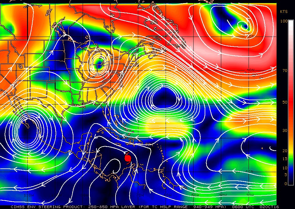
06Z 250-850mb steering currents.
0 likes
Just a small town southern boy helping other humans.
-
Bocadude85

- Category 5

- Posts: 2991
- Age: 39
- Joined: Mon Apr 18, 2005 2:20 pm
- Location: Honolulu,Hi
Re: ATL: MATTHEW - Hurricane - Discussion
Matthew isn't forecast to cross 75W until 25N..that's a lot of northward movement from where he is now...better stop moving wnw now.
Last edited by Bocadude85 on Sun Oct 02, 2016 2:16 am, edited 1 time in total.
0 likes
-
PTrackerLA

- Category 5
- Posts: 5281
- Age: 42
- Joined: Thu Oct 10, 2002 8:40 pm
- Location: Lafayette, LA
Re: ATL: MATTHEW - Hurricane - Discussion
It's amazing how that feeder band to the east has not let up for over a day. Thankfully there hasn't been any land to affect it's been producing deeper convection than Matthew for a while.
1 likes
-
Evil Jeremy

- S2K Supporter
- Posts: 5463
- Age: 32
- Joined: Mon Apr 10, 2006 2:10 pm
- Location: Los Angeles, CA
Re: ATL: MATTHEW - Hurricane - Discussion
The WNW march continues. I'd make a friendly wager that Matthew crosses 75W before 15N, which would really mess with the current forecast.
0 likes
Frances 04 / Jeanne 04 / Katrina 05 / Wilma 05 / Fay 08 / Debby 12 / Andrea 13 / Colin 16 / Hermine 16 / Matthew 16 / Irma 17
-
AutoPenalti
- Category 5
- Posts: 4091
- Age: 29
- Joined: Mon Aug 17, 2015 4:16 pm
- Location: Ft. Lauderdale, Florida
Re: ATL: MATTHEW - Hurricane - Discussion
Caught this snippet from this morning which could be what's happening right now
northjaxpro wrote:You can see the very western extent (nose of the ridge) extends to the western edge of Cuba. If the trough in the GOM does not dig deeper to help erode that ridge further, it is possible the ridge may hold and keep Matthew moving a bit farther west just a bit longer
0 likes
The posts in this forum are NOT official forecasts and should not be used as such. They are just the opinion of the poster and may or may not be backed by sound meteorological data. They are NOT endorsed by any professional institution or STORM2K. For official information, please refer to products from the NHC and NWS.
Model Runs Cheat Sheet:
GFS (5:30 AM/PM, 11:30 AM/PM)
HWRF, GFDL, UKMET, NAVGEM (6:30-8:00 AM/PM, 12:30-2:00 AM/PM)
ECMWF (1:45 AM/PM)
TCVN is a weighted averaged
-
brunota2003
- S2K Supporter
- Posts: 9476
- Age: 35
- Joined: Sat Jul 30, 2005 9:56 pm
- Location: Stanton, KY...formerly Havelock, NC
- Contact:
Re: ATL: MATTHEW - Hurricane - Discussion
When you are using the steering current charts, the stronger the storm, the higher you need to click on, on CIMMS. If you look at the buttons, it gives you a rough mb and knot range. Right now, Matthew "should" be the 200mb, but it's movement fits more with the 250mb one.
1 likes
Just a small town southern boy helping other humans.
-
northjaxpro

- S2K Supporter
- Posts: 8900
- Joined: Mon Sep 27, 2010 11:21 am
- Location: Jacksonville, FL
Re: ATL: MATTHEW - Hurricane - Discussion
AutoPenalti wrote:Caught this snippet from this morning which could be what's happening right nowYou can see the very western extent (nose of the ridge) extends to the western edge of Cuba. If the trough in the GOM does not dig deeper to help erode that ridge further, it is possible the ridge may hold and keep Matthew moving a bit farther west just a bit longer
I made this observation yesterday. Thanks for briniging this back up. Indeed, it may be a possibilty that this may be going on right now!
1 likes
NEVER, EVER SAY NEVER in the tropics and weather in general, and most importantly, with life itself!!
________________________________________________________________________________________
Fay 2008 Beryl 2012 Debby 2012 Colin 2016 Hermine 2016 Julia 2016 Matthew 2016 Irma 2017 Dorian 2019
________________________________________________________________________________________
Fay 2008 Beryl 2012 Debby 2012 Colin 2016 Hermine 2016 Julia 2016 Matthew 2016 Irma 2017 Dorian 2019
-
northjaxpro
- S2K Supporter
- Posts: 8900
- Joined: Mon Sep 27, 2010 11:21 am
- Location: Jacksonville, FL
Re: ATL: MATTHEW - Hurricane - Discussion
How about another player on the scene now folks. NHC a short time ago has designated Invest 98L out in the Central Atlantic. That could factor in possibly in helping to keep Matthew away from the U.S. East Coast.. We will have to see.
Long week ahead with so many uncertainties still on the table with Matthew.
Long week ahead with so many uncertainties still on the table with Matthew.
0 likes
NEVER, EVER SAY NEVER in the tropics and weather in general, and most importantly, with life itself!!
________________________________________________________________________________________
Fay 2008 Beryl 2012 Debby 2012 Colin 2016 Hermine 2016 Julia 2016 Matthew 2016 Irma 2017 Dorian 2019
________________________________________________________________________________________
Fay 2008 Beryl 2012 Debby 2012 Colin 2016 Hermine 2016 Julia 2016 Matthew 2016 Irma 2017 Dorian 2019
-
SouthernBreeze

- Category 1

- Posts: 284
- Age: 69
- Joined: Tue Aug 31, 2004 4:54 pm
- Location: SC/NC line- on the SC Coast
Re: ATL: MATTHEW - Hurricane - Discussion
it's up to 20% & 30% development chances now, we'll soon see
0 likes
My posts are NOT official forecast and should not be used as such. It's just my opinion and not backed by sound meteorological data, and NOT endorsed by any professional institution or storm2k.org. For official information, please refer to the NHC and NWS products.
grazed by many - most wind damage: Hugo (pre-cellphone days!) & most water: Floyd
grazed by many - most wind damage: Hugo (pre-cellphone days!) & most water: Floyd
-
AutoPenalti
- Category 5
- Posts: 4091
- Age: 29
- Joined: Mon Aug 17, 2015 4:16 pm
- Location: Ft. Lauderdale, Florida
Re: ATL: MATTHEW - Hurricane - Discussion
northjaxpro wrote:How about another player on the scene now folks. NHC a short time ago has designated Invest 98L out in the Central Atlantic. That could factor in possibly in helping to keep Matthew away from the U.S. East Coast.. We will have to see.
Long week ahead with so many uncertainties still on the table with Matthew.
Some invest this is...

0 likes
The posts in this forum are NOT official forecasts and should not be used as such. They are just the opinion of the poster and may or may not be backed by sound meteorological data. They are NOT endorsed by any professional institution or STORM2K. For official information, please refer to products from the NHC and NWS.
Model Runs Cheat Sheet:
GFS (5:30 AM/PM, 11:30 AM/PM)
HWRF, GFDL, UKMET, NAVGEM (6:30-8:00 AM/PM, 12:30-2:00 AM/PM)
ECMWF (1:45 AM/PM)
TCVN is a weighted averaged
-
SouthernBreeze
- Category 1
- Posts: 284
- Age: 69
- Joined: Tue Aug 31, 2004 4:54 pm
- Location: SC/NC line- on the SC Coast
Re: ATL: MATTHEW - Hurricane - Discussion
looks like it just went "Poof" (lol). I don't see where those development percentages come in!
0 likes
My posts are NOT official forecast and should not be used as such. It's just my opinion and not backed by sound meteorological data, and NOT endorsed by any professional institution or storm2k.org. For official information, please refer to the NHC and NWS products.
grazed by many - most wind damage: Hugo (pre-cellphone days!) & most water: Floyd
grazed by many - most wind damage: Hugo (pre-cellphone days!) & most water: Floyd
Re: ATL: MATTHEW - Hurricane - Discussion
As northjax and others have mentioned, Matthew appears to be going west of forecast. The 0z Euro's 24 hour forecast (for 8 PM EDT Sunday) is for him to be near 15.0N, 74.5W. But he is already to near 74.0W while still down near 13.8N! He's going to need to average a NNW heading over the next 16+ hours for this to get to near the Euro 24 hour forecast point. This is looking pretty unlikely as of now but it isn't impossible. We'll see.
0 likes
Personal Forecast Disclaimer:
The posts in this forum are NOT official forecasts and should not be used as such. They are just the opinion of the poster and may or may not be backed by sound meteorological data. They are NOT endorsed by any professional institution or storm2k.org. For official information, please refer to the NHC and NWS products.
The posts in this forum are NOT official forecasts and should not be used as such. They are just the opinion of the poster and may or may not be backed by sound meteorological data. They are NOT endorsed by any professional institution or storm2k.org. For official information, please refer to the NHC and NWS products.
-
bamajammer4eva
- Category 4

- Posts: 907
- Joined: Sun Apr 18, 2010 3:21 am
- Location: Ozark, AL
Re: ATL: MATTHEW - Hurricane - Discussion
Oh well stranger things have happened like with the storm name from 1998 which Matthew replaced. Perhaps Mitch's ghost is haunting Matthew 
https://en.wikipedia.org/wiki/Hurricane_Mitch
Initially, the National Hurricane Center (NHC) and various tropical cyclone forecast models anticipated a turn to the north, threatening the Yucatán peninsula. Instead, Mitch turned to the south due to a ridge that was not observed while the storm was active.
https://en.wikipedia.org/wiki/Hurricane_Mitch
Last edited by bamajammer4eva on Sun Oct 02, 2016 2:53 am, edited 1 time in total.
0 likes
-
AtlanticWind

- S2K Supporter
- Posts: 1898
- Age: 67
- Joined: Sun Aug 08, 2004 9:57 pm
- Location: Plantation,Fla
Re: ATL: MATTHEW - Hurricane - Discussion
Not gaining latitude yet ,could change the models for sure
0 likes
-
ozonepete
- Professional-Met

- Posts: 4743
- Joined: Mon Sep 07, 2009 3:23 pm
- Location: From Ozone Park, NYC / Now in Brooklyn, NY
Re: ATL: MATTHEW - Hurricane - Discussion
Weakening for sure. Cloud tops have warmed noticeably and the eye is open to the southwest.


0 likes
-
AutoPenalti
- Category 5
- Posts: 4091
- Age: 29
- Joined: Mon Aug 17, 2015 4:16 pm
- Location: Ft. Lauderdale, Florida
Re: ATL: MATTHEW - Hurricane - Discussion
ozonepete wrote:Weakening for sure. Cloud tops have warmed noticeably and the eye is open to the southwest.
I've notice that as well, but it looks to be temporary. Still moving W/WNW.
Last edited by AutoPenalti on Sun Oct 02, 2016 3:05 am, edited 1 time in total.
0 likes
The posts in this forum are NOT official forecasts and should not be used as such. They are just the opinion of the poster and may or may not be backed by sound meteorological data. They are NOT endorsed by any professional institution or STORM2K. For official information, please refer to products from the NHC and NWS.
Model Runs Cheat Sheet:
GFS (5:30 AM/PM, 11:30 AM/PM)
HWRF, GFDL, UKMET, NAVGEM (6:30-8:00 AM/PM, 12:30-2:00 AM/PM)
ECMWF (1:45 AM/PM)
TCVN is a weighted averaged

Re: ATL: MATTHEW - Hurricane - Discussion
I'll list this link here and in the Model thread, but am simply doing so for those curious about Matthew's present motion in relation to forecast track (which is heavily based on model input). This link is for the Model Diagnostic Discussion, which views which models seem to best be handling the various steering and upper level features over the CONUS. Makes for interesting reading as ridge heights, troughs, etc. are analyzed verses various model guidance and often foretells of upcoming nuances that might influence Matthew's future motion. For those who don't have it, here is the link:
http://www.wpc.ncep.noaa.gov/discussion ... isc=pmdhmd
http://www.wpc.ncep.noaa.gov/discussion ... isc=pmdhmd
0 likes
Andy D
(For official information, please refer to the NHC and NWS products.)
(For official information, please refer to the NHC and NWS products.)
-
brunota2003
- S2K Supporter
- Posts: 9476
- Age: 35
- Joined: Sat Jul 30, 2005 9:56 pm
- Location: Stanton, KY...formerly Havelock, NC
- Contact:
Re: ATL: MATTHEW - Hurricane - Discussion
If Matthew's motion continues, it looks like the eye should cross 75W around 14.3N
0 likes
Just a small town southern boy helping other humans.
-
SouthernBreeze
- Category 1
- Posts: 284
- Age: 69
- Joined: Tue Aug 31, 2004 4:54 pm
- Location: SC/NC line- on the SC Coast
Re: ATL: MATTHEW - Hurricane - Discussion
chaser1 wrote:I'll list this link here and in the Model thread, but am simply doing so for those curious about Matthew's present motion in relation to forecast track (which is heavily based on model input). This link is for the Model Diagnostic Discussion, which views which models seem to best be handling the various steering and upper level features over the CONUS. Makes for interesting reading as ridge heights, troughs, etc. are analyzed verses various model guidance and often foretells of upcoming nuances that might influence Matthew's future motion. For those who don't have it, here is the link:
http://www.wpc.ncep.noaa.gov/discussion ... isc=pmdhmd
Interesting for sure: ...GRADUAL WEAKENING AND RETREAT OF THE SUBTROPICAL RIDGE OVER THE
WESTERN ATLANTIC OCEAN IS EXPECTED TO ALLOW POWERFUL HURRICANE
MATTHEW OVER THE SOUTHERN CARIBBEAN SEA TURN GRADUALLY TO
NORTHWEST AND THEN NORTH OVER THE NEXT FEW DAYS...
0 likes
My posts are NOT official forecast and should not be used as such. It's just my opinion and not backed by sound meteorological data, and NOT endorsed by any professional institution or storm2k.org. For official information, please refer to the NHC and NWS products.
grazed by many - most wind damage: Hugo (pre-cellphone days!) & most water: Floyd
grazed by many - most wind damage: Hugo (pre-cellphone days!) & most water: Floyd
Re: ATL: MATTHEW - Hurricane - Discussion
Looks like it'll be squeezed between the trough approaching from the NW and the ridge to the NE which seems stronger than expected - IMHO not liking this setup for us here in South Florida, though perhaps it might force a NNE motion - we shall see...
P.S. Do the pro mets know why this hurricane seems to be cojoined to a constant large blob of deep convection to its east - unusual...
My posts are NOT official forecast and should not be used as such. It's just my opinion and not backed by sound meteorological data, and NOT endorsed by any professional institution or storm2k.org. For official information, please refer to the NHC and NWS products.
Last edited by Frank2 on Sun Oct 02, 2016 3:39 am, edited 4 times in total.
0 likes
Who is online
Users browsing this forum: No registered users and 7 guests