ATL: MATTHEW - Post-Tropical - Discussion

Moderator: S2k Moderators

Message
Author
User avatar
chaser1
S2K Supporter
S2K Supporter
Posts: 5509
Age: 64
Joined: Sat Oct 15, 2005 5:59 pm
Location: Longwood, Fl

Re: ATL: MATTHEW - Hurricane - Discussion

#5101 Postby chaser1 » Tue Oct 04, 2016 12:49 am

eastcoastFL wrote:
chaser1 wrote:
Floridagal wrote:
The obvious things-food, water, gas, batteries, flashlight, candles. A weather radio. Power outages can happen fairly quickly even inland as trees go down. Tornadoes are a very real possibility...you will want to monitor this. I make sure my yard is free of anything that can blow around or away. A manual can opener-learned that lesson the hard way after Charley. People are going to go through far, far worse, but I was without power for 9 days after Charley. It is unpleasant to say the least. Have the basic necessities and you'll adapt.


Don't forget cell phone, extra battery or power source, cash (ATM's will be down if no power), and gather passports ID's & important papers which can be kept dry in garbage bags. If your family lives in a trailer they should not stay if there's any risk of gusts to hurricane force.


Do you expect evac for treasure coast east of US 1?


Based on what I've seen thus far, yes. I'd imagine East of US 1 up around Stuart/Jensen Beach area to probably be evacuated.
0 likes   
Andy D

(For official information, please refer to the NHC and NWS products.)

ozonepete
Professional-Met
Professional-Met
Posts: 4743
Joined: Mon Sep 07, 2009 3:23 pm
Location: From Ozone Park, NYC / Now in Brooklyn, NY

Re: ATL: MATTHEW - Hurricane - Discussion

#5102 Postby ozonepete » Tue Oct 04, 2016 12:49 am

TJRE wrote:
ozonepete wrote:Matthew is clearly expanding to a really large size. Even if it doesn't landfall at the Florida coast it's becoming more likely that it will have some strong wind and wave effects there. I'd be paying really close attention.


Pete
thanks again for all your tutoring in the past :wink:
T from jersey


You're my pal. I'm sure you'll be watching this closely with me since we could have big effects here as well. :)
1 likes   

User avatar
Evil Jeremy
S2K Supporter
S2K Supporter
Posts: 5463
Age: 32
Joined: Mon Apr 10, 2006 2:10 pm
Location: Los Angeles, CA

Re: ATL: MATTHEW - Hurricane - Discussion

#5103 Postby Evil Jeremy » Tue Oct 04, 2016 12:49 am

SouthFLTropics wrote:
northjaxpro wrote:Tonight is taking me back to the old days of of 2004 when tracking Frances and Jeanne. Man those days were something else. Stayiing up late into the wee hours of the morning, awaiting the model runs. Well tonight is giving me the same feeling with Matthew breathing down our necks here along the Florida East Coast and SE U.S. Coast.

Awaiting EURO run at 1:45 a.m. , about 15 minutes from now.


I remember those days all too well. Tough times but I have fond memories of past discussions on S2K.


I wasn't here for the 2004/05 rush but I've had my fair share of late nights on here... and a couple more this week. It's the upside of being under hurricane threat.
0 likes   
Frances 04 / Jeanne 04 / Katrina 05 / Wilma 05 / Fay 08 / Debby 12 / Andrea 13 / Colin 16 / Hermine 16 / Matthew 16 / Irma 17

User avatar
AdamFirst
S2K Supporter
S2K Supporter
Posts: 2491
Age: 36
Joined: Thu Aug 14, 2008 10:54 am
Location: Port Saint Lucie, FL

Re: ATL: MATTHEW - Hurricane - Discussion

#5104 Postby AdamFirst » Tue Oct 04, 2016 12:50 am

chaser1 wrote:
Based on what I've seen thus far, yes. I'd imagine East of US 1 up around Stuart/Jensen Beach area to probably be evacuated.


Usually for high end storms the area surrounding both forks of the St. Lucie River is evacuated. Surge will be a bit harder to predict from this storm however, due to the angle of approach.
0 likes   
Dolphins Marlins Canes Golden Panthers HEAT
Andrew 1992 - Irene 1999 - Frances 2004 - Jeanne 2004 - Wilma 2005 - Fay 2008 - Isaac 2012 - Matthew 2016 - Irma 2017 - Dorian 2019 - Ian 2022 - Nicole 2022 - Milton 2024

ozonepete
Professional-Met
Professional-Met
Posts: 4743
Joined: Mon Sep 07, 2009 3:23 pm
Location: From Ozone Park, NYC / Now in Brooklyn, NY

Re: ATL: MATTHEW - Hurricane - Discussion

#5105 Postby ozonepete » Tue Oct 04, 2016 12:52 am

northjaxpro wrote:
ozonepete wrote:Matthew is clearly expanding to a really large size. Even if it doesn't landfall at the Florida coast it's becoming more likely that it will have some strong wind and wave effects there. I'd be paying really close attention.


Hey oxonepete. Tomorrow looks to be a very hectic day for me and many others preparing for the arrival.of Matthew. It almost feels surreal to see a powerful major hurricane to be literally right at my doorstep .


Sooner or later it was bound to happen. It still looks like you will be on the weaker side but you have to wait another 1 or 2 days to be sure. Of course I know you're glued to the data anyway just like the rest of us. :)
0 likes   

User avatar
SouthFLTropics
Category 5
Category 5
Posts: 4239
Age: 50
Joined: Thu Aug 14, 2003 8:04 am
Location: Port St. Lucie, Florida

Re: ATL: MATTHEW - Hurricane - Discussion

#5106 Postby SouthFLTropics » Tue Oct 04, 2016 12:52 am

I named my first born son after Hurricane Andrew. Never did I dream that my second son, Matthew, would come to haunt Florida as well.
1 likes   
Fourth Generation Florida Native

Personal Storm History: David 79, Andrew 92, Erin 95, Floyd 99, Irene 99, Frances 04, Jeanne 04, Wilma 05, Matthew 16, Irma 17, Ian 22, Nicole 22, Milton 24

User avatar
hurricanefloyd5
Category 5
Category 5
Posts: 1659
Age: 44
Joined: Sun May 02, 2004 10:53 am
Location: Spartanburg
Contact:

Re: ATL: MATTHEW - Hurricane - Discussion

#5107 Postby hurricanefloyd5 » Tue Oct 04, 2016 12:53 am

Interests elsewhere in Hispaniola, the Bahamas, and in the Florida
Peninsula and the Florida Keys should monitor the progress of
Matthew.
0 likes   

User avatar
hurricanefloyd5
Category 5
Category 5
Posts: 1659
Age: 44
Joined: Sun May 02, 2004 10:53 am
Location: Spartanburg
Contact:

Re: ATL: MATTHEW - Hurricane - Discussion

#5108 Postby hurricanefloyd5 » Tue Oct 04, 2016 12:54 am

hurricanefloyd5 wrote:Interests elsewhere in Hispaniola, the Bahamas, and in the Florida
Peninsula and the Florida Keys should monitor the progress of
Matthew.


:eek: :eek:
0 likes   

User avatar
Blinhart
Category 5
Category 5
Posts: 2081
Age: 48
Joined: Thu Sep 08, 2011 3:13 pm
Location: Crowley, La.

Re: ATL: MATTHEW - Hurricane - Discussion

#5109 Postby Blinhart » Tue Oct 04, 2016 12:58 am

10+ storm surges in the Bahamas, that will destroy a lot of the man made islands and cost billions of dollars in damage. This might go down as the costliest storm in recorded history.
0 likes   
Personal Forecast Disclaimer:
The posts in this forum are NOT official forecast and should not be used as such. They are just the opinion of the poster and may or may not be backed by sound meteorological data. They are NOT endorsed by any professional institution or storm2k.org. For official information, please refer to the NHC and NWS products.

ozonepete
Professional-Met
Professional-Met
Posts: 4743
Joined: Mon Sep 07, 2009 3:23 pm
Location: From Ozone Park, NYC / Now in Brooklyn, NY

Re: ATL: MATTHEW - Hurricane - Discussion

#5110 Postby ozonepete » Tue Oct 04, 2016 12:59 am

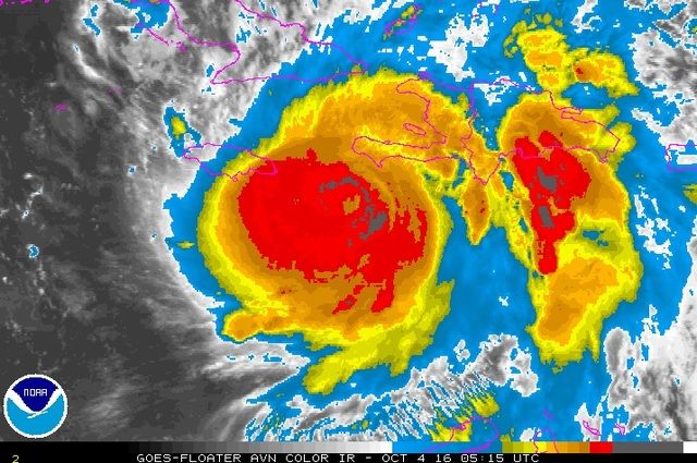
Finally it looks like an ERC that's for real is occurring as far as the inner eye seems to have truly collapsed. That's good news for Haiti since the initial collapse of the inner eyewall is accompanied by a weakening. Unfortunately this storm is so strong that it may only go from 145 mph winds to 135 or 140 mph winds. Some ERCs reduce the core speed a lot more than others. Let's hope.
This is a massive storm and they will be under hurricane conditions a long time.

Image
Last edited by ozonepete on Tue Oct 04, 2016 1:00 am, edited 1 time in total.
0 likes   

Aric Dunn
Category 5
Category 5
Posts: 21238
Age: 42
Joined: Sun Sep 19, 2004 9:58 pm
Location: Ready for the Chase.
Contact:

Re: ATL: MATTHEW - Hurricane - Discussion

#5111 Postby Aric Dunn » Tue Oct 04, 2016 12:59 am

next 24 hours are key..

we have the synoptics roughly in place... plenty of ridging. next thing we must watch for is land interaction and seeing if the center get caught up on any of the high terrian. we have seen in the past many times this issue. its possible to slow the forward motion quite substantially due ot weakening and reformations and likely in this case what I call the "tether ball" effect.
0 likes   
Note: If I make a post that is brief. Please refer back to previous posts for the analysis or reasoning. I do not re-write/qoute what my initial post said each time.
If there is nothing before... then just ask :)

Space & Atmospheric Physicist, Embry-Riddle Aeronautical University,
I believe the sky is falling...

User avatar
AdamFirst
S2K Supporter
S2K Supporter
Posts: 2491
Age: 36
Joined: Thu Aug 14, 2008 10:54 am
Location: Port Saint Lucie, FL

Re: ATL: MATTHEW - Hurricane - Discussion

#5112 Postby AdamFirst » Tue Oct 04, 2016 1:00 am

SUMMARY OF 200 AM EDT...0600 UTC...INFORMATION
----------------------------------------------
LOCATION...17.4N 74.5W
ABOUT 60 MI...100 KM S OF TIBURON HAITI
ABOUT 165 MI...270 KM WSW OF PORT AU PRINCE HAITI
MAXIMUM SUSTAINED WINDS...145 MPH...230 KM/H
PRESENT MOVEMENT...N OR 010 DEGREES AT 8 MPH...13 KM/H
MINIMUM CENTRAL PRESSURE...934 MB...27.58 INCHES
0 likes   
Dolphins Marlins Canes Golden Panthers HEAT
Andrew 1992 - Irene 1999 - Frances 2004 - Jeanne 2004 - Wilma 2005 - Fay 2008 - Isaac 2012 - Matthew 2016 - Irma 2017 - Dorian 2019 - Ian 2022 - Nicole 2022 - Milton 2024

User avatar
SouthFLTropics
Category 5
Category 5
Posts: 4239
Age: 50
Joined: Thu Aug 14, 2003 8:04 am
Location: Port St. Lucie, Florida

Re: ATL: MATTHEW - Hurricane - Discussion

#5113 Postby SouthFLTropics » Tue Oct 04, 2016 1:01 am

Aric Dunn wrote:next 24 hours are key..

we have the synoptics roughly in place... plenty of ridging. next thing we must watch for is land interaction and seeing if the center get caught up on any of the high terrian. we have seen in the past many times this issue. its possible to slow the forward motion quite substantially due ot weakening and reformations and likely in this case what I call the "tether ball" effect.


I like this thought and terminology. Please have "tether ball effect" added to the Storm2k termoinology dictionary.
0 likes   
Fourth Generation Florida Native

Personal Storm History: David 79, Andrew 92, Erin 95, Floyd 99, Irene 99, Frances 04, Jeanne 04, Wilma 05, Matthew 16, Irma 17, Ian 22, Nicole 22, Milton 24

Aric Dunn
Category 5
Category 5
Posts: 21238
Age: 42
Joined: Sun Sep 19, 2004 9:58 pm
Location: Ready for the Chase.
Contact:

Re: ATL: MATTHEW - Hurricane - Discussion

#5114 Postby Aric Dunn » Tue Oct 04, 2016 1:03 am

ozonepete wrote:Finally it looks like an ERC that's for real is occurring as far as the inner eye seems to have truly collapsed. That's good news for Haiti since the initial collapse of the inner eyewall is accompanied by a weakening. Unfortunately this storm is so strong that it may only go from 145 mph winds to 135 or 140 mph winds. Some ERCs reduce the core speed a lot more than others. Let's hope.

Image


hate to burst your bubble my friend.. but its the terrain interaction likely causing pressure waves/drag differentials. just remember a parcel of air and path of least resistance in terms of a fluid. you put objects in the path you will get turbulence. this no different..
0 likes   
Note: If I make a post that is brief. Please refer back to previous posts for the analysis or reasoning. I do not re-write/qoute what my initial post said each time.
If there is nothing before... then just ask :)

Space & Atmospheric Physicist, Embry-Riddle Aeronautical University,
I believe the sky is falling...

AModestLion
Tropical Wave
Tropical Wave
Posts: 7
Joined: Mon Oct 03, 2016 6:26 pm

Re: ATL: MATTHEW - Hurricane - Discussion

#5115 Postby AModestLion » Tue Oct 04, 2016 1:05 am

I know it's still early, but for right now, does it look like 98L will have any impact on the US or Matthew?
0 likes   

User avatar
Blinhart
Category 5
Category 5
Posts: 2081
Age: 48
Joined: Thu Sep 08, 2011 3:13 pm
Location: Crowley, La.

Re: ATL: MATTHEW - Hurricane - Discussion

#5116 Postby Blinhart » Tue Oct 04, 2016 1:06 am

Aric Dunn wrote:
ozonepete wrote:Finally it looks like an ERC that's for real is occurring as far as the inner eye seems to have truly collapsed. That's good news for Haiti since the initial collapse of the inner eyewall is accompanied by a weakening. Unfortunately this storm is so strong that it may only go from 145 mph winds to 135 or 140 mph winds. Some ERCs reduce the core speed a lot more than others. Let's hope.

Image


hate to burst your bubble my friend.. but its the terrain interaction likely causing pressure waves/drag differentials. just remember a parcel of air and path of least resistance in terms of a fluid. you put objects in the path you will get turbulence. this no different..


Looks like he is putting up a fight against going up through the passage, looks like he wants to stay in the Caribbean. (No mommy I don't want to go, don't make me go)
1 likes   
Personal Forecast Disclaimer:
The posts in this forum are NOT official forecast and should not be used as such. They are just the opinion of the poster and may or may not be backed by sound meteorological data. They are NOT endorsed by any professional institution or storm2k.org. For official information, please refer to the NHC and NWS products.

Socalhurcnegirl227
Category 1
Category 1
Posts: 267
Age: 36
Joined: Mon Jun 06, 2016 6:39 pm
Location: Santa Barbara, CA

Re: ATL: MATTHEW - Hurricane - Discussion

#5117 Postby Socalhurcnegirl227 » Tue Oct 04, 2016 1:08 am

AModestLion wrote:I know it's still early, but for right now, does it look like 98L will have any impact on the US or Matthew?

accordig to multiple outlets such as jeff from wunderground they dont expect it to weaken the ridge much
1 likes   
"I'm a wandress, i'm a one night stand,
dont belong to no city, dont belong to no man
i'm the violence in the pouring rain,
I'm a hurricane"

User avatar
WxGuy1
Professional-Met
Professional-Met
Posts: 538
Joined: Sat Oct 22, 2005 12:55 pm
Location: Oklahoma

Re: ATL: MATTHEW - Hurricane - Discussion

#5118 Postby WxGuy1 » Tue Oct 04, 2016 1:17 am

ozonepete wrote:Finally it looks like an ERC that's for real is occurring as far as the inner eye seems to have truly collapsed. That's good news for Haiti since the initial collapse of the inner eyewall is accompanied by a weakening. Unfortunately this storm is so strong that it may only go from 145 mph winds to 135 or 140 mph winds. Some ERCs reduce the core speed a lot more than others. Let's hope.
This is a massive storm and they will be under hurricane conditions a long time.


From the 2 am EDT public advisory: "Hurricane-force winds extend outward up to 40 miles (65 km) from the center and tropical-storm-force winds extend outward up to 185 miles (295 km)."
From the 11 pm EDT forecast advisory: "ESTIMATED MINIMUM CENTRAL PRESSURE 934 MB
EYE DIAMETER 15 NM
MAX SUSTAINED WINDS 125 KT WITH GUSTS TO 150 KT.
64 KT....... 35NE 30SE 30SW 30NW."

The largest diagonal of the hurricane-strength winds is ~65 miles in diameter (35 NE to 30 SW). That doesn't seem to be particularly large for a Cat 4 hurricane. Compare this to something like Hurricane Ike, which had a swath of 64+kt winds of over 150 miles at one time. Looking through some past Cat 4-5 hurricanes in the Atlantic basin, it certainly doesn't look like Matthew's wind field (of hurricane-strength winds) is large by any means. Recon data show that the gradient in winds is extremely high near the eyewall; this isn't particularly uncommon, though it seems that the area of high winds in Matthew is smaller than I'd expect for a <940 mb hurricane.
0 likes   

Aric Dunn
Category 5
Category 5
Posts: 21238
Age: 42
Joined: Sun Sep 19, 2004 9:58 pm
Location: Ready for the Chase.
Contact:

Re: ATL: MATTHEW - Hurricane - Discussion

#5119 Postby Aric Dunn » Tue Oct 04, 2016 1:19 am

also adding to this "tether ball effect" i have mentioned over the years. this nne almost Ne moition is very likely do to this effect. the right side of the circ is pilling up against the mountains creating a lower field of pressure in that area. it will migrate that way. but come tomorrow it will have competing drag from hati and cuba upon the circ its going to get bounced around quite a bit .. thats why i have been saying its important to watch this unfold. models might react accordingly
0 likes   
Note: If I make a post that is brief. Please refer back to previous posts for the analysis or reasoning. I do not re-write/qoute what my initial post said each time.
If there is nothing before... then just ask :)

Space & Atmospheric Physicist, Embry-Riddle Aeronautical University,
I believe the sky is falling...

User avatar
Blinhart
Category 5
Category 5
Posts: 2081
Age: 48
Joined: Thu Sep 08, 2011 3:13 pm
Location: Crowley, La.

Re: ATL: MATTHEW - Hurricane - Discussion

#5120 Postby Blinhart » Tue Oct 04, 2016 1:20 am

WxGuy1 wrote:
ozonepete wrote:Finally it looks like an ERC that's for real is occurring as far as the inner eye seems to have truly collapsed. That's good news for Haiti since the initial collapse of the inner eyewall is accompanied by a weakening. Unfortunately this storm is so strong that it may only go from 145 mph winds to 135 or 140 mph winds. Some ERCs reduce the core speed a lot more than others. Let's hope.
This is a massive storm and they will be under hurricane conditions a long time.


From the 2 am EDT public advisory: "Hurricane-force winds extend outward up to 40 miles (65 km) from the center and tropical-storm-force winds extend outward up to 185 miles (295 km)."
From the 11 pm EDT forecast advisory: "ESTIMATED MINIMUM CENTRAL PRESSURE 934 MB
EYE DIAMETER 15 NM
MAX SUSTAINED WINDS 125 KT WITH GUSTS TO 150 KT.
64 KT....... 35NE 30SE 30SW 30NW."

The largest diagonal of the hurricane-strength winds is ~65 miles in diameter (35 NE to 30 SW). That doesn't seem to be particularly large for a Cat 4 hurricane. Compare this to something like Hurricane Ike, which had a swath of 64+kt winds of over 150 miles at one time. Looking through some past Cat 4-5 hurricanes in the Atlantic basin, it certainly doesn't look like Matthew's wind field (of hurricane-strength winds) is large by any means. Recon data show that the gradient in winds is extremely high near the eyewall; this isn't particularly uncommon, though it seems that the area of high winds in Matthew is smaller than I'd expect for a <940 mb hurricane.


But surface obs from Haiti might change that, last I heard one of their stations went down with sustained 85 mph wind with gust to 105 mph, if I remember correctly.
0 likes   
Personal Forecast Disclaimer:
The posts in this forum are NOT official forecast and should not be used as such. They are just the opinion of the poster and may or may not be backed by sound meteorological data. They are NOT endorsed by any professional institution or storm2k.org. For official information, please refer to the NHC and NWS products.


Return to “2016”

Who is online

Users browsing this forum: No registered users and 16 guests