ATL: MATTHEW - Post-Tropical - Discussion
Moderator: S2k Moderators
-
meriland23

- Category 5

- Posts: 1239
- Age: 38
- Joined: Mon Aug 29, 2011 9:29 pm
Re: ATL: MATTHEW - Hurricane - Discussion
could anyone post the latest radar loop in terms of intensity? I am on my mobile and having a tough time with sites
0 likes
The posts in this forum are NOT official forecast and should not be used as such. They are just the opinion of the poster and may or may not be backed by sound meteorological data. They are NOT endorsed by any professional institution or storm2k.org. For official information, please refer to the NHC and NWS products.
-
WilmingtonSandbar
- S2K Supporter

- Posts: 505
- Joined: Sun Aug 29, 2010 12:11 pm
- Location: Southport, NC
Re: ATL: MATTHEW - Hurricane - Discussion
So, someone earlier may have brought this up and if so, I apologize. The other day when Nicole formed, it was stated quite vehemently that she was not strong enough to effect the ridging ahead of Matthew. Now that she is a hurricane, is she strong enough?
1 likes
Diana X2 (look it up), Bertha, Fran, Bonnie, Floyd, Dennis, Charley, Ophelia, Ernesto, Irene, Matthew, And Florence
Re: ATL: MATTHEW - Hurricane - Discussion
Is anyone else experiencing multiple missing images in all satellite loops?
0 likes

Re: ATL: MATTHEW - Hurricane - Discussion
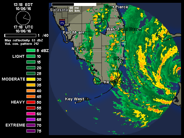
SapphireSea wrote:bjackrian wrote:NHC wind graphic shows the potential for current TS winds over portions of SE FL. Has anyone seen ground verification of that? I recognize the disclaimer at the bottom of the graphic with "potential for" language, but hadn't seen anything above 30kt sustained in my searching.
Map may be correct. Here in Fort Lauderdale I have not seen any 30kt sustained winds at all. A few gusts may have come close, no TS gusts either even in some of the squalls, but I do know that squalls can vary greatly in strength.

There are over 10,000 customers without power along the east coast. Those power outages occur during the squalls as the rain bands come through. 1 minute sustained winds above 34 knots in those squall lines are the usual culprit. I haven't seen evidence of any Hurricane force winds (yet).
Good map
0 likes
Re: ATL: MATTHEW - Hurricane - Discussion
ZX12R wrote:Portastorm wrote:sbcc wrote:
I did the same yesterday, first time donation. Same reasons.
Thanks very much!
I contributed late last night while I was drinking. I hope I didn't contribute thousands of dollars.
You did...
Help support Storm2K!

5 likes
Opinions expressed by this poster are purely conjecture on his part and have no basis in reality. As such, taking any advice from me would be foolish, and potentially deadly.

Re: ATL: MATTHEW - Hurricane - Discussion
Cuda wrote:KBBOCA wrote:Interesting wind visualization
Found this at Wunderground blog. Don't know the original source
That's beautiful. Thanks for posting.

There is a free android app that animates wind data this way - I use it all the time when planning my fishing trips.
https://play.google.com/store/apps/details?id=com.acmeaom.android.myradar&hl=en

0 likes

Re: ATL: MATTHEW - Hurricane - Discussion
Shout out to Weatherbell and specifically Ryan Mauie for calling out the big wig conspiracy idiots. When you are peddling to the paranoid and they have a life stake in the game, don't tell them the government and National Hurricane Center is trumping up wind speed to make a political point. That may be the dumbest thing I've ever heard. I'm not saying the sources are in any way legitimate or responsible, consider them. But millions of people go there for their fix of whatever it is they're getting a fix on. It's like somebody painted "Green" on this Funktop to make it look worse. Haha. No ******* way. Nobody but the stormchasers want to be on that FL East Coast in a few hours.
http://www.ssd.noaa.gov/PS/TROP/floater ... imated.gif
http://www.ssd.noaa.gov/PS/TROP/floater ... imated.gif
Last edited by Steve on Thu Oct 06, 2016 4:52 pm, edited 1 time in total.
3 likes
-
SouthFLTropics

- Category 5
- Posts: 4258
- Age: 50
- Joined: Thu Aug 14, 2003 8:04 am
- Location: Port St. Lucie, Florida
Re: ATL: MATTHEW - Hurricane - Discussion
Well crap...I've just lost power in Port St. Lucie. And the wind is hardly blowing.
2 likes
Fourth Generation Florida Native
Personal Storm History: David 79, Andrew 92, Erin 95, Floyd 99, Irene 99, Frances 04, Jeanne 04, Wilma 05, Matthew 16, Irma 17, Ian 22, Nicole 22, Milton 24
Personal Storm History: David 79, Andrew 92, Erin 95, Floyd 99, Irene 99, Frances 04, Jeanne 04, Wilma 05, Matthew 16, Irma 17, Ian 22, Nicole 22, Milton 24
-
bamajammer4eva
- Category 4

- Posts: 907
- Joined: Sun Apr 18, 2010 3:21 am
- Location: Ozark, AL
Re: ATL: MATTHEW - Hurricane - Discussion
Looks like it did took a decent jolt west if the eyewalls are merging and have possibly expanded

1 likes

Re: ATL: MATTHEW - Hurricane - Discussion
Friends, I need some advice here. My mother-in-law (almost 90 years old) lives by herself in a home near (but not on) the St. Johns River in Jacksonville. It's a brick home but built well before the Andrew standards. She has refused our pleas to evacuate but now is at the point where she admits that she doesn't want to "inconvenience" us. We live in Sarasota and it takes between 4 and 5 hours to drive to her home. We can leave tonight and pick her up and be back in Sarasota before dawn tomorrow. Will I be able to get gas on the way back and will the weather deteriorate too badly for us to do this?
0 likes

-
Hypercane_Kyle

- Category 5
- Posts: 3465
- Joined: Sat Mar 07, 2015 7:58 pm
- Location: Cape Canaveral, FL
Re: ATL: MATTHEW - Hurricane - Discussion
Hammy wrote:Hypercane_Kyle wrote:Inner wall is going west for the same reasons it looked like it was going N-NNW earlier; outer eyewall is causing the inner eyewall to oscillate like a gyro.
Is this similar to what happened with Wilma in 2005, the eye essentially rotating around the edge of the outer eyewall?
Yes, although not nearly as dramatic.
0 likes
My posts are my own personal opinion, defer to the National Hurricane Center (NHC) and other NOAA products for decision making during hurricane season.
Re: ATL: MATTHEW - Hurricane - Discussion
Madpoodle wrote:ZX12R wrote:Portastorm wrote:
Thanks very much!
I contributed late last night while I was drinking. I hope I didn't contribute thousands of dollars.
You did...Help support Storm2K!
Wonderful. At least it wasn't wasted.
5 likes
Re: ATL: MATTHEW - Hurricane - Discussion
NDG wrote:And now a WNW jog.
It's almost as if Matthew is just avoiding land at all cost now.

1 likes
-
ozonepete
- Professional-Met

- Posts: 4743
- Joined: Mon Sep 07, 2009 3:23 pm
- Location: From Ozone Park, NYC / Now in Brooklyn, NY
Re: ATL: MATTHEW - Hurricane - Discussion
ZX12R wrote:Is anyone else experiencing multiple missing images in all satellite loops?
Yup. But they seem to have stopped it from re-occurring.
0 likes
-
SapphireSea
- Category 1

- Posts: 430
- Joined: Wed Aug 24, 2005 12:13 pm
- Location: Miami, FL
Re: ATL: MATTHEW - Hurricane - Discussion
WilmingtonSandbar wrote:So, someone earlier may have brought this up and if so, I apologize. The other day when Nicole formed, it was stated quite vehemently that she was not strong enough to effect the ridging ahead of Matthew. Now that she is a hurricane, is she strong enough?
The issue with Nicole was that she tightened up into a very tiny system to affect the ridge at the time. A very sharp wave/trough is enough to help erode a mid-level ridge. A TS/HUR can erode mid level ridges but pump upper level ridges up. But in the case of Nicole, she is too small to have affected the ridge heavily.
0 likes
-
AutoPenalti
- Category 5
- Posts: 4091
- Age: 29
- Joined: Mon Aug 17, 2015 4:16 pm
- Location: Ft. Lauderdale, Florida
Re: ATL: MATTHEW - Hurricane - Discussion
Looks like people in SFL are pissed off and have become completely complacent.
Comments like "I did all this for nothing", "I bought all his food" "news always hypes up storms" "I will never believe another news channel again" "next hurricane will be a cat 5 and they will hype it up again and then it gets close and steers away"
Comments like "I did all this for nothing", "I bought all his food" "news always hypes up storms" "I will never believe another news channel again" "next hurricane will be a cat 5 and they will hype it up again and then it gets close and steers away"
2 likes
The posts in this forum are NOT official forecasts and should not be used as such. They are just the opinion of the poster and may or may not be backed by sound meteorological data. They are NOT endorsed by any professional institution or STORM2K. For official information, please refer to products from the NHC and NWS.
Model Runs Cheat Sheet:
GFS (5:30 AM/PM, 11:30 AM/PM)
HWRF, GFDL, UKMET, NAVGEM (6:30-8:00 AM/PM, 12:30-2:00 AM/PM)
ECMWF (1:45 AM/PM)
TCVN is a weighted averaged
-
KBBOCA
- S2K Supporter
- Posts: 1559
- Joined: Fri Sep 05, 2003 5:27 am
- Location: Formerly Boca Raton, often West Africa. Currently Charlotte NC
Re: ATL: MATTHEW - Hurricane - Discussion
Bouy SPGF1 is on the western tip of Freeport, I believe. Getting slammed
http://www.ndbc.noaa.gov/station_page.php?station=spgf1
http://www.ndbc.noaa.gov/show_plot.php? ... _label=EDT

http://www.ndbc.noaa.gov/station_page.php?station=spgf1
http://www.ndbc.noaa.gov/show_plot.php? ... _label=EDT
0 likes
-
Aric Dunn
- Category 5
- Posts: 21238
- Age: 43
- Joined: Sun Sep 19, 2004 9:58 pm
- Location: Ready for the Chase.
- Contact:
Re: ATL: MATTHEW - Hurricane - Discussion
davidiowx wrote:NDG wrote:And now a WNW jog.
It's almost as if Matthew is just avoiding land at all cost now.
look how much that outer eyewall has contracted.. thats quick..
1 likes
Note: If I make a post that is brief. Please refer back to previous posts for the analysis or reasoning. I do not re-write/qoute what my initial post said each time.
If there is nothing before... then just ask
Space & Atmospheric Physicist, Embry-Riddle Aeronautical University,
I believe the sky is falling...
If there is nothing before... then just ask
Space & Atmospheric Physicist, Embry-Riddle Aeronautical University,
I believe the sky is falling...
-
Frank P
- S2K Supporter
- Posts: 2779
- Joined: Fri Aug 29, 2003 10:52 am
- Location: Biloxi Beach, Ms
- Contact:
Re: ATL: MATTHEW - Hurricane - Discussion
davidiowx wrote:NDG wrote:And now a WNW jog.
It's almost as if Matthew is just avoiding land at all cost now.
Looks like the outer eye wall is actuall getting smaller... still looks overall NW to me..
0 likes
Who is online
Users browsing this forum: No registered users and 47 guests