ATL: INVEST 99L - Discussion
Moderator: S2k Moderators
Re: ATL: INVEST 99L - Discussion
Surface to 700mb looks pretty well stacked.
On the SE side of the UL trough.
Trough is forecasted to weaken to a ULL in about 30 hrs and gone in about 60 hrs.
Looking on WV and how its filling in, that may occur a little earlier.
https://earth.nullschool.net/#current/w ... 346,24.172
On the SE side of the UL trough.
Trough is forecasted to weaken to a ULL in about 30 hrs and gone in about 60 hrs.
Looking on WV and how its filling in, that may occur a little earlier.
https://earth.nullschool.net/#current/w ... 346,24.172
1 likes
Re: ATL: INVEST 99L - Models
Looking at Tuesday's 00Z Euro and COAMPs runs, this is getting pretty close to New England.
Since it will likely be extratropical by then, very likely a good portion from NJ to Canadian Maritimes will feel the effects.
Since it will likely be extratropical by then, very likely a good portion from NJ to Canadian Maritimes will feel the effects.
1 likes
Re: ATL: INVEST 99L - Discussion
1004mb at Providenciales, Turks Islands
https://www.wunderground.com/cgi-bin/fi ... &sp=M3FFL8
https://www.wunderground.com/cgi-bin/fi ... &sp=M3FFL8
0 likes
- cycloneye
- Admin

- Posts: 149367
- Age: 69
- Joined: Thu Oct 10, 2002 10:54 am
- Location: San Juan, Puerto Rico
Re: ATL: INVEST 99L - Discussion
Shower activity associated with a well-defined, non-tropical low
pressure system located just to the northeast of the Turks and
Caicos has changed little during the past several hours. The low is
expected to slowly intensify as upper-level winds become more
conducive, and a subtropical or tropical cyclone could form during
the next couple of days while the low moves northward on Wednesday
and turns north-northwestward or northwestward on Thursday.
* Formation chance through 48 hours...medium...40 percent
* Formation chance through 5 days...high...70 percent
0 likes
Visit the Caribbean-Central America Weather Thread where you can find at first post web cams,radars
and observations from Caribbean basin members Click Here
and observations from Caribbean basin members Click Here
Re: ATL: INVEST 99L - Discussion
Looks like the UL trough is already dissipating and transistioning to an ULL at 25N 74W
http://www.ssd.noaa.gov/PS/TROP/floater ... -long.html
http://www.ssd.noaa.gov/PS/TROP/floater ... -long.html
1 likes
Re: ATL: INVEST 99L - Models
06Z GFS is showing the MS-Vally surface low as deepening compared to earlier runs.
It is forecast to track to New England, and combine with 99L,
http://www.tropicaltidbits.com/analysis ... 5702727522
It is forecast to track to New England, and combine with 99L,
http://www.tropicaltidbits.com/analysis ... 5702727522
0 likes
Re: ATL: INVEST 99L - Discussion
WEATHER RECONNAISSANCE FLIGHTS
CARCAH, NATIONAL HURRICANE CENTER, MIAMI, FL.
1030 AM EDT TUE 18 OCTOBER 2016
SUBJECT: TROPICAL CYCLONE PLAN OF THE DAY (TCPOD)
VALID 19/1100Z TO 20/1100Z OCTOBER 2016
TCPOD NUMBER.....16-145
I. ATLANTIC REQUIREMENTS
1. SUSPECT AREA (NORTH OF THE BAHAMAS)
FLIGHT ONE - NOAA 43
A. 19/1800Z
B. NOAA3 01GGA INVEST
C. 19/1500Z
D. 26.5N 68.5W
E. 19/1730Z TO 19/2030Z
F. SFC TO 15,000 FT
2. OUTLOOK FOR SUCCEEDING DAY: FIX OF THIS SYSTEM
AT 20/1730Z NEAR 27.0N 70.5W
0 likes
- AJC3
- Admin

- Posts: 4153
- Age: 62
- Joined: Tue Aug 31, 2004 7:04 pm
- Location: Ballston Spa, New York
- Contact:
ATL: INVEST 99L - Recon
WEATHER RECONNAISSANCE FLIGHTS
CARCAH, NATIONAL HURRICANE CENTER, MIAMI, FL.
1030 AM EDT TUE 18 OCTOBER 2016
SUBJECT: TROPICAL CYCLONE PLAN OF THE DAY (TCPOD)
VALID 19/1100Z TO 20/1100Z OCTOBER 2016
TCPOD NUMBER.....16-145
I. ATLANTIC REQUIREMENTS
1. SUSPECT AREA (NORTH OF THE BAHAMAS)
FLIGHT ONE - NOAA 43
A. 19/1800Z
B. NOAA3 01GGA INVEST
C. 19/1500Z
D. 26.5N 68.5W
E. 19/1730Z TO 19/2030Z
F. SFC TO 15,000 FT
2. OUTLOOK FOR SUCCEEDING DAY: FIX OF THIS SYSTEM
AT 20/1730Z NEAR 27.0N 70.5W
II. PACIFIC REQUIREMENTS
1. NEGATIVE RECONNAISSANCE REQUIREMENTS.
2. SUCCEEDING DAY OUTLOOK.....NEGATIVE.
$$
0 likes
-
tolakram
- Admin

- Posts: 20183
- Age: 62
- Joined: Sun Aug 27, 2006 8:23 pm
- Location: Florence, KY (name is Mark)
Re: ATL: INVEST 99L - Discussion
Lots of swirls.
visible loop
http://weather.msfc.nasa.gov/cgi-bin/get-goes?satellite=GOES-E%20CONUS&lat=24&lon=-69&info=vis&zoom=2&width=1000&height=800&quality=90&type=Animation&palette=ir1.pal&numframes=10&mapcolor=yellow
visible loop
http://weather.msfc.nasa.gov/cgi-bin/get-goes?satellite=GOES-E%20CONUS&lat=24&lon=-69&info=vis&zoom=2&width=1000&height=800&quality=90&type=Animation&palette=ir1.pal&numframes=10&mapcolor=yellow
0 likes
M a r k
- - - - -
Join us in chat: Storm2K Chatroom Invite. Android and IOS apps also available.
The posts in this forum are NOT official forecasts and should not be used as such. Posts are NOT endorsed by any professional institution or STORM2K.org. For official information and forecasts, please refer to NHC and NWS products.
- 'CaneFreak
- Category 5

- Posts: 1487
- Joined: Mon Jun 05, 2006 10:50 am
- Location: New Bern, NC
Re: ATL: INVEST 99L - Discussion
Yes! Definitely very unorganized at the moment. It will be interesting to see how this one plays out. Upstream ridges and downstream troughs have plagued the models in the past. We'll see what it does.
0 likes
Re: ATL: INVEST 99L - Discussion
12z GFS shows it merging with a low coming from the Ohio Valley.
0 likes
Re: ATL: INVEST 99L - Discussion
Ken711 wrote:12z GFS shows it merging with a low coming from the Ohio Valley.
Looks like it may bomb in New England
0 likes
- 'CaneFreak
- Category 5

- Posts: 1487
- Joined: Mon Jun 05, 2006 10:50 am
- Location: New Bern, NC
Re: ATL: INVEST 99L - Discussion
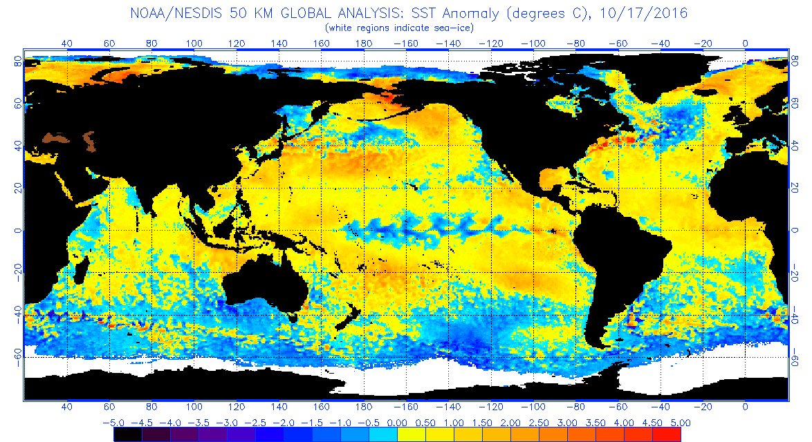
That is exactly what I am afraid of. I don't think it would be a Sandy #2 but the water sure is warm in the northwestern extent of the Gulf Stream right now and the 500 mb heights in the Northeast are forecasted to run well below normal.

http://www.tropicaltidbits.com/analysis/models/?model=gfs®ion=atl&pkg=z500a&runtime=2016101812&fh=90&xpos=0&ypos=200

http://www.tropicaltidbits.com/analysis/models/?model=gfs®ion=atl&pkg=z500a&runtime=2016101812&fh=90&xpos=0&ypos=200
GCANE wrote: Looks like it may bomb in New England
1 likes
- 'CaneFreak
- Category 5

- Posts: 1487
- Joined: Mon Jun 05, 2006 10:50 am
- Location: New Bern, NC
Re: ATL: INVEST 99L - Discussion
TROPICAL WEATHER OUTLOOK
NWS NATIONAL HURRICANE CENTER MIAMI FL
200 PM EDT TUE OCT 18 2016
For the North Atlantic...Caribbean Sea and the Gulf of Mexico:
Shower and thunderstorm activity has increased and become a little
better organized since yesterday in association with a well-defined,
non-tropical low pressure system located a couple of hundred miles
northeast of the Turks and Caicos. The low is expected to acquire
some tropical characteristics as upper-level winds become more
conducive, and a subtropical or tropical cyclone will likely form
during the next few days. The low is forecast to move northward on
Wednesday and turn northwestward on Thursday, before heading
northeastward out to sea by the end of the week. A NOAA Hurricane
Hunter aircraft is scheduled to investigate this system tomorrow
afternoon, if necessary.
* Formation chance through 48 hours...medium...50 percent
* Formation chance through 5 days...high...80 percent
$$
Forecaster Stewart
0 likes
- 'CaneFreak
- Category 5

- Posts: 1487
- Joined: Mon Jun 05, 2006 10:50 am
- Location: New Bern, NC
Re: ATL: INVEST 99L - Models
Don't look at the latest EURO. Yuck. It agrees with the GFS. It looks like the storm is coming up the coast. You have a trough-ridge-trough pattern between the East Coast trough, the Canadian Maritimes Ridge, and a Greenland low. That's a very stable pattern.
http://www.tropicaltidbits.com/analysis/models/ecmwf/2016101812/ecmwf_z500a_atl_4.png
http://www.tropicaltidbits.com/analysis/models/ecmwf/2016101812/ecmwf_z500a_atl_4.png
0 likes
Re: ATL: INVEST 99L - Models
12Z GFS combines the lows over the Hudson Valley and bombs it over Maine.
http://tc.met.psu.edu/tcgengifs/GFS/2016101812/slp.anim
http://tc.met.psu.edu/tcgengifs/GFS/2016101812/slp.anim
0 likes
- 'CaneFreak
- Category 5

- Posts: 1487
- Joined: Mon Jun 05, 2006 10:50 am
- Location: New Bern, NC
Re: ATL: INVEST 99L - Models
Yeah it keeps the two lows separate though. Follow the low associated with this disturbance carefully. It stays along the southern edge of the trough over the NE and never combines with it. Taking a second look at the 12Z Euro, it looks like it does the same thing too but it is a step closer to a full phase. It's going to be an interesting next few days.
GCANE wrote:12Z GFS combines the lows over the Hudson Valley and bombs it over Maine.
http://tc.met.psu.edu/tcgengifs/GFS/2016101812/slp.anim
0 likes
-
emeraldislenc
- Category 2

- Posts: 601
- Joined: Fri Aug 24, 2012 4:49 pm
- Location: Emerald Isle NC
- 'CaneFreak
- Category 5

- Posts: 1487
- Joined: Mon Jun 05, 2006 10:50 am
- Location: New Bern, NC
Re: ATL: INVEST 99L - Discussion
Check back on Thu. We'll have a better idea.
emeraldislenc wrote:How close will this get to
The NC coast?
0 likes
Who is online
Users browsing this forum: No registered users and 125 guests


