
Personally for me, (not getting bogged into a debate, simply just passing along anecdotal gossip), but if I see it and I feel it, it's happening. Especially being a native Austinite still living in the neighborhood that I grew up in, even the types of plants that we used to have in our gardens in the 80s, won't survive here now.
Used to have tons of giant Live Oaks which covered the hood with a continuous canopy. More than half either died from Oak Wilt disease which arrived for the first time in this area in 92, or from the multi-year drought we recently endured. The majority of the trees lost were apart of a large established Live Oak forest that had been here long before the neighborhood was. The trees were connected through the root system which is why the disease spread so quickly. The neighborhood tried trenching with the help from the city but I think by the time they started, it was too little too late.
Some of the trees, like our next door neighbors, were over 500 years old according to the loggers that cut the dead remains down. They counted and recorded the rings of each. The Oak in our side yard was a little more than 150 years old. Still have the stump sticking out of the ground and I use it as a table for potted plants. To try to shorten what is already a long post, the loss of those trees completely transformed the neighborhood. The aftermath can be clearly seen all over the hood with the stumps, like grave stones, reminding everyone that a forest used to reside here not so long ago. I should take a picture of our neighbors and post it so y'all can get an idea of just how big around the trunk was.
There's a silver lining side story that's pretty interesting. One of the trees in the back of our other neighbors yard was never cut down other than a few branches. Several Hackberry trees grew and intertwined with it so it was left mostly intact. For 15 years the skeleton stuck out of the cluster of surrounding trees occasionally losing a large branch here and there. Then around 2006 to 2007, I just happened to be staring at it when I noticed something different. Up on the end of the highest bony branch, there were bunches of leaves. Naturally the first thing that came to mind was mistletoe. I kept an eye on it over the next several months and to my shock and suprise, that bare ragged skeleton was actually still alive after all those years. New branches began growing and more leaves popped up but at a sluggish pace.
For about 5 years it was very slowly adding small branches here and there but overall it was pretty sparse. Then about 2012-2013 while several trees in the area which barely survived the Oak Wilt, and had been struggling ever since, began to die from the extreme drought. However it began to take off growing and has been growing quickly since. Now the top section has a full canopy. We've speculated about it many times and came to the conclusion that it obviously didn't completely die and that it must have some sort of unique genetic variation which is immune to Oak Wilt. Was just the craziest thing that it laid dormant for 15 years.
Those neighbors are long gone. The house and yard are in limbo but will be eventually redeveloped with 3 houses. Some friends of ours suggested that we contact someone at Texas A&M and tell them about the tree. If it has a unique genetic variation they could come check it out. The really cool thing is it produced acorns for the first time year before last and 4 saplings popped up in our yard. We are keeping 3 and will give my sister one to plant in her yard. My hope is that the young ones carry whatever trait that kept the parent from dying. To my knowledge, it is the only remnant tree that revived in the hood. Several other neighbors have also taken interest in the tree.
I apologize for such a long post but since we've been reminiscing over past years and politely chatting about the changing climate while we patiently wait for something significant to happen, (Possibly maybe as early as Halloween according to this afternoon's EWX discussion) I wanted to post about what physical effects have occured in my neighborhood since i've lived here all my life and have been able to witness the results, largly do to a shift in climate to which has also been linked and attributed to the spread of Oak Wilt into the Austin area in the early 90s.
I also studied Environmental Sciences in collage and given the evidence and general rules that when you increase a certain atmospheric gas the overall composition of the atmosphere begins to change over time, for me there is no question about it but again take what you will from my ramblings. One thing that I've come to enjoy is that while we may have varying differences in opinions regarding weather and/or climate. We stay polite and respect each other. After following the Hurricane Mathew thread, I find it humbling that even when in disagreement, we stay civil and respectful. There's nothing wrong with an exchange of thoughts and ideas. It's a good way to read and reflect on different points of view.
Well now I've really gone and made this post into a novel lol. I'll log out now before I start a sequel. Hope everyone is enjoying this day. Hope we get some rain next week!
Texas Fall-2016
Moderator: S2k Moderators
Forum rules

The posts in this forum are NOT official forecast and should not be used as such. They are just the opinion of the poster and may or may not be backed by sound meteorological data. They are NOT endorsed by any professional institution or STORM2K.
Re: Texas Fall-2016
3 likes
Resident Rain Miser
I am a weather hobbyist living 3.5 miles south of Downtown Austin and in no way or fashion should anything I say concerning forecasts be taken seriously. Please check your local NWS for accurate weather forecasting and conditions.
I am a weather hobbyist living 3.5 miles south of Downtown Austin and in no way or fashion should anything I say concerning forecasts be taken seriously. Please check your local NWS for accurate weather forecasting and conditions.
-
horselattitudesfarm

- Category 1

- Posts: 315
- Joined: Thu Jul 16, 2009 5:55 pm
- Location: Asheville, NC (formerly from Dallas, TX)
Re: Texas Fall-2016
I haven't posted in a long time but, living here in Western North Carolina, we are in one heck of a drought. I didn't know this area could get such bad drought: The thick lush forests here don't suggest it could get this bad. Six weeks without a drop of rain has happened twice in 4 months. Anyway, something I've noticed living in both Texas and now NC. is that when hurricanes recurve to the east, areas to their west suffer from drought for a long long time. I cannot remember what hurricane it was that went east of Texas that caused the huge fires in Bastrop, but after Mathew went east of western north carolina, the weather dynamics just 'died' and now the pattern is 'unbreakable' to use the exact words of our local mets. Hurricane Ike did the same thing after skirting Houston to the east back in 2005: Houston didn't get normal rainfall again for years as I remember. So my question is: Is it the hurricanes that screw up the abilility to have normal rainfall for areas or is it a bigger pattern that is causing the hurricanes AND ALSO causing drought to move in after them?
0 likes

Re: Texas Fall-2016
horselattitudesfarm wrote:I haven't posted in a long time but, living here in Western North Carolina, we are in one heck of a drought. I didn't know this area could get such bad drought: The thick lush forests here don't suggest it could get this bad. Six weeks without a drop of rain has happened twice in 4 months. Anyway, something I've noticed living in both Texas and now NC. is that when hurricanes recurve to the east, areas to their west suffer from drought for a long long time. I cannot remember what hurricane it was that went east of Texas that caused the huge fires in Bastrop, but after Mathew went east of western north carolina, the weather dynamics just 'died' and now the pattern is 'unbreakable' to use the exact words of our local mets. Hurricane Ike did the same thing after skirting Houston to the east back in 2005: Houston didn't get normal rainfall again for years as I remember. So my question is: Is it the hurricanes that screw up the abilility to have normal rainfall for areas or is it a bigger pattern that is causing the hurricanes AND ALSO causing drought to move in after them?
It's a little bit of both. Very active hurricane seasons tend to follow an El Nino especially ones that become La Nina. These summers tend to begin severe drought in the Southeastern US (i.e 1998, 2007, 2010, 2016) and when there is a second La Nina it tends to migrate westward towards Texas (1999, 2008, 2011). The stubborn southeastern US ridge is a staple of La Nina and is the larger scale culprit. As for the hurricanes themselves, yes behind them is subsidence and on a large scale they wavebreak and scour moisture after their passage. Remember the purpose of a warm core system such as a hurricane is not to cool, but to bring heat. They remove stored heat in the ocean into the atmosphere, unlike a cold core system that is colder winds aloft when you are talking about just an ULL.
0 likes
The above post and any post by Ntxw is NOT an official forecast and should not be used as such. It is just the opinion of the poster and may or may not be backed by sound meteorological data. It is NOT endorsed by any professional institution including Storm2k. For official information, please refer to NWS products.
Help support Storm2K!
-
Brent
- S2K Supporter

- Posts: 38740
- Age: 37
- Joined: Sun May 16, 2004 10:30 pm
- Location: Tulsa Oklahoma
- Contact:
Re: Texas Fall-2016
For your nightly GFS update... the 0z GFS is entirely above normal for Texas through 384 hours... which gets us into mid-November.
0 likes
#neversummer
-
horselattitudesfarm
- Category 1
- Posts: 315
- Joined: Thu Jul 16, 2009 5:55 pm
- Location: Asheville, NC (formerly from Dallas, TX)
Re: Texas Fall-2016
Thank you NTX for that excellent explanation. Also, our forecast discussion pro-mets have a similar sense of humor as yours with the record-breaking heat here in western NC as follows:
therwise, the front will push east of the area through the morning
hours with surface high pressure over the Midwest working its way
into the Appalachians. Weak upper shortwave axis will push east
giving way to northwest flow aloft but with ridging building in
quickly this evening. As the surface high pushes east and toward the
Coastal Plain, northwest downsloping winds will be short-lived and
will swing around to the east, bringing in Atlantic moisture to
modify the dry airmass associated with the surface high. This
combined with the increasing thicknesses aloft with the building
ridge will lead to temperatures well above seasonal normals today,
about 10 degrees or so. Lows tonight will also be above normal but
not quite as bad as highs. Clear skies with at least somewhat
improved visibility should result in a very beautiful late summer
day (with the obvious problem that it`s the end of October, but I
digress).
0 likes
-
Yukon Cornelius
- S2K Supporter
- Posts: 1842
- Age: 42
- Joined: Thu Dec 20, 2012 9:23 pm
- Location: Dean, TX/Westcliffe, CO
Re: Texas Fall-2016
Brent wrote:For your nightly GFS update... the 0z GFS is entirely above normal for Texas through 384 hours... which gets us into mid-November.
Winter cancel
0 likes
#neversummer
-
aggiecutter
- Category 5

- Posts: 1755
- Joined: Thu Oct 14, 2004 9:22 pm
- Location: Texarkana
Re: Texas Fall-2016
Shreveport's NBC affiliate meteorologist Todd Warren's winter outlook. Cold and dry. The exception being December, which will be wet. The link is below. The winter outlook starts at the 1:00 minute mark of the video:
https://www.facebook.com/video.php?v=1136320126457408
https://www.facebook.com/video.php?v=1136320126457408
0 likes
-
arizona_sooner
- Tropical Depression

- Posts: 64
- Joined: Sat Jan 09, 2010 10:09 am
- Location: Peoria, AZ
Re: Texas Fall-2016
Definitely a warm October. Was 100F yesterday in Phoenix, a record for the date and the latest 100F reading ever. Ugh.
0 likes
Re: Texas Fall-2016
The Euro weeklies last night still painted a similar picture. Get through the first week of November and we will all be OK  . The GOA will retrograde and the warm NPAC waters will restrengthen and do business in the EPO.
SOI is crashing negative, which is definitely not a signature of La Nina, more of an El Nino. Hopefully this crash will mean a boost of any semblance to the subtropical jet. In the past about a week or so later translates to some kind of rain event. Hopefully that will come to fruition

SOI is crashing negative, which is definitely not a signature of La Nina, more of an El Nino. Hopefully this crash will mean a boost of any semblance to the subtropical jet. In the past about a week or so later translates to some kind of rain event. Hopefully that will come to fruition
0 likes
The above post and any post by Ntxw is NOT an official forecast and should not be used as such. It is just the opinion of the poster and may or may not be backed by sound meteorological data. It is NOT endorsed by any professional institution including Storm2k. For official information, please refer to NWS products.
Help support Storm2K!
Help support Storm2K!
-
Portastorm

- Storm2k Moderator

- Posts: 9955
- Age: 63
- Joined: Fri Jul 11, 2003 9:16 am
- Location: Round Rock, TX
- Contact:
Re: Texas Fall-2016
Yep ... I was just perusing those Euro weeklies and Ntxw, as usual, is spot on. Sometime around the middle of November we should see a big pattern change and a cool down for Texas. The storm track also looks active per those same Euro weekies. Also, the MJO is progged to be in stages 7-8 albeit not real strong.
We shouldn't have to wait too much longer for real Fall.
We shouldn't have to wait too much longer for real Fall.
1 likes
Any forecasts under my name are to be taken with a grain of salt. Get your best forecasts from the National Weather Service and National Hurricane Center.
-
TheAustinMan

- Category 5
- Posts: 1060
- Joined: Mon Jul 08, 2013 4:26 pm
- Location: Central TX / United States
Re: Texas Fall-2016
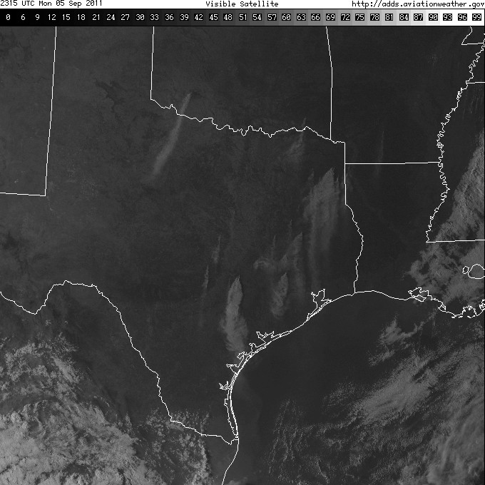
horselattitudesfarm wrote:... I cannot remember what hurricane it was that went east of Texas that caused the huge fires in Bastrop ...
Ugh... that would be Tropical Storm Lee in 2011, which meandered off the coast and swept strong northerly winds across Texas. The resulting fires were particularly devastating not just in Bastrop but across East Texas, while areas under Lee's canopy suffered from extensive flooding. I'll let this image tell the tale.
0 likes
Treat my opinions with a grain of salt. For official information see your local weather service.
“It's tough to make predictions, especially about the future.”
“It's tough to make predictions, especially about the future.”
-
weatherdude1108
- Category 5
- Posts: 4228
- Joined: Tue Dec 13, 2011 1:04 pm
- Location: Northwest Austin/Cedar Park, TX
Re: Texas Fall-2016
TheAustinMan wrote:horselattitudesfarm wrote:... I cannot remember what hurricane it was that went east of Texas that caused the huge fires in Bastrop ...
Ugh... that would be Tropical Storm Lee in 2011, which meandered off the coast and swept strong northerly winds across Texas. The resulting fires were particularly devastating not just in Bastrop but across East Texas, while areas under Lee's canopy suffered from extensive flooding. I'll let this image tell the tale.
What a God-awful year that was.
0 likes
The preceding post is NOT an official forecast, and should not be used as such. It is only the opinion of the poster and may or may not be backed by sound meteorological data. It is NOT endorsed by any professional institution including storm2k.org. For Official Information please refer to the NHC and NWS products.
-
Tireman4

- S2K Supporter
- Posts: 5903
- Age: 60
- Joined: Fri Jun 30, 2006 1:08 pm
- Location: Humble, Texas
- Contact:
Re: Texas Fall-2016
weatherdude1108 wrote:TheAustinMan wrote:horselattitudesfarm wrote:... I cannot remember what hurricane it was that went east of Texas that caused the huge fires in Bastrop ...
Ugh... that would be Tropical Storm Lee in 2011, which meandered off the coast and swept strong northerly winds across Texas. The resulting fires were particularly devastating not just in Bastrop but across East Texas, while areas under Lee's canopy suffered from extensive flooding. I'll let this image tell the tale.
What a God-awful year that was.
Oh man. THE.WORST.SUMMER. EVER ( Quoting Porta) Yeah, that was the worst.
0 likes
-
Portastorm
- Storm2k Moderator
- Posts: 9955
- Age: 63
- Joined: Fri Jul 11, 2003 9:16 am
- Location: Round Rock, TX
- Contact:
Re: Texas Fall-2016
Please don't mention that year again.
0 likes
Any forecasts under my name are to be taken with a grain of salt. Get your best forecasts from the National Weather Service and National Hurricane Center.
Re: Texas Fall-2016
We have seen a period like this before. Oct-Nov of 1983. GOA low dominated much of the month before flipping the second half of November and boy when it did, did it ever flip and never looked back. We all are familiar with the culminating period into December. The reason I mention this because ENSO is very close to the projections as did occur then. We were coming out of a Super El Nino (1982-1983) that was meager for DFW and then La Nina failed to strengthen (La Nada) held into 1984 as it is doing now. Given, it was not as warm back then than it is now which will likely be the warmest October on record.
CPC superembles weights the above normal height pattern through the next 11 days with the period of 1983 several times

The interesting thing about it all is, this type of pattern is more El Nino like in the northern latitudes (very strong Aleutian-GOA low and warm) but the lack of rainfall (as was in 1983) is that the cold waters of the equatorial Pacific says the opposite thing. Will the Aleutian ridge make an emergence, as it does with many cold neutral/weak Nina seasons? TPB's warm waters below the Aleutians will give us a clue should it move east/northeast.
CPC superembles weights the above normal height pattern through the next 11 days with the period of 1983 several times
The interesting thing about it all is, this type of pattern is more El Nino like in the northern latitudes (very strong Aleutian-GOA low and warm) but the lack of rainfall (as was in 1983) is that the cold waters of the equatorial Pacific says the opposite thing. Will the Aleutian ridge make an emergence, as it does with many cold neutral/weak Nina seasons? TPB's warm waters below the Aleutians will give us a clue should it move east/northeast.
2 likes
The above post and any post by Ntxw is NOT an official forecast and should not be used as such. It is just the opinion of the poster and may or may not be backed by sound meteorological data. It is NOT endorsed by any professional institution including Storm2k. For official information, please refer to NWS products.
Help support Storm2K!
Help support Storm2K!
-
Tireman4
- S2K Supporter
- Posts: 5903
- Age: 60
- Joined: Fri Jun 30, 2006 1:08 pm
- Location: Humble, Texas
- Contact:
Re: Texas Fall-2016
[quote="Ntxw"]. Given, it was not as warm back then than it is now which will likely be the warmest October on record.
Yeah, I would agree. Your analysis has been spot on so many years now. In Houston, I fear this October will be in the top 3 at least. The warmest was 2004. That Halloween was brutal .
IAH Warmest Octobers
77.5 2004
76.7 1963
76.5 1947
Yeah, I would agree. Your analysis has been spot on so many years now. In Houston, I fear this October will be in the top 3 at least. The warmest was 2004. That Halloween was brutal .
IAH Warmest Octobers
77.5 2004
76.7 1963
76.5 1947
0 likes
-
Brent
- S2K Supporter
- Posts: 38740
- Age: 37
- Joined: Sun May 16, 2004 10:30 pm
- Location: Tulsa Oklahoma
- Contact:
Re: Texas Fall-2016
Ntxw wrote:We have seen a period like this before. Oct-Nov of 1983. GOA low dominated much of the month before flipping the second half of November and boy when it did, did it ever flip and never looked back. We all are familiar with the culminating period into December. The reason I mention this because ENSO is very close to the projections as did occur then. We were coming out of a Super El Nino (1982-1983) that was meager for DFW and then La Nina failed to strengthen (La Nada) held into 1984 as it is doing now. Given, it was not as warm back then than it is now which will likely be the warmest October on record.
CPC superembles weights the above normal height pattern through the next 11 days with the period of 1983 several times
The interesting thing about it all is, this type of pattern is more El Nino like in the northern latitudes (very strong Aleutian-GOA low and warm) but the lack of rainfall (as was in 1983) is that the cold waters of the equatorial Pacific says the opposite thing. Will the Aleutian ridge make an emergence, as it does with many cold neutral/weak Nina seasons? TPB's warm waters below the Aleutians will give us a clue should it move east/northeast.
How about 1977-1978? I was noticing on the warmest Halloweens 1977 is at the top(and I already knew about the winter that year from research), and we're likely only gonna be 1 or 2 degrees behind it, and while there were still record highs in early December, the pattern flipped and that's the snowiest winter ever in DFW... all in January/February(over 17 inches). Caught my eye anyway...
1 likes
#neversummer
Re: Texas Fall-2016
Brent wrote:How about 1977-1978? I was noticing on the warmest Halloweens 1977 is at the top(and I already knew about the winter that year from research), and we're likely only gonna be 1 or 2 degrees behind it, and while there were still record highs in early December, the pattern flipped and that's the snowiest winter ever in DFW... all in January/February(over 17 inches). Caught my eye anyway...
I was only looking strictly at ENSO years with a similar relation. 1977-1978 was a second year weak Nino so ENSO wise isn't a very good match from that perspective. But there is some correlation to having a warmer Oct or Nov, or both to flip years since 1950. But then again you had last year that kept on rolling with no flip.
0 likes
The above post and any post by Ntxw is NOT an official forecast and should not be used as such. It is just the opinion of the poster and may or may not be backed by sound meteorological data. It is NOT endorsed by any professional institution including Storm2k. For official information, please refer to NWS products.
Help support Storm2K!
Help support Storm2K!
-
Brent
- S2K Supporter
- Posts: 38740
- Age: 37
- Joined: Sun May 16, 2004 10:30 pm
- Location: Tulsa Oklahoma
- Contact:
Re: Texas Fall-2016
Ntxw wrote:Brent wrote:How about 1977-1978? I was noticing on the warmest Halloweens 1977 is at the top(and I already knew about the winter that year from research), and we're likely only gonna be 1 or 2 degrees behind it, and while there were still record highs in early December, the pattern flipped and that's the snowiest winter ever in DFW... all in January/February(over 17 inches). Caught my eye anyway...
I was only looking strictly at ENSO years with a similar relation. 1977-1978 was a second year weak Nino so ENSO wise isn't a very good match from that perspective. But there is some correlation to having a warmer Oct or Nov, or both to flip years since 1950. But then again you had last year that kept on rolling with no flip.
lol right... I still have some level of skepticism with this winter but I've been looking for optimistic signs.
The GFS has a big cold snap around Veterans Day again, granted it's fantasy land, but it's been a pretty consistent signal so far. This run is really cold with highs in the 40s.

The Euro is back onboard with a huge rain event next weekend, while the GFS is more routine.
0 likes
#neversummer
-
aggiecutter
- Category 5
- Posts: 1755
- Joined: Thu Oct 14, 2004 9:22 pm
- Location: Texarkana
Re: Texas Fall-2016
Joe Bastardi @BigJoeBastardi 2h2 hours ago Pennsylvania, USA
Major crash of SOI will do a number on the La nina, and signals big changes for US weather pattern mid Nov-Dec. Early winter this year
0 likes
Return to “USA & Caribbean Weather”
Who is online
Users browsing this forum: CaptinCrunch and 74 guests