It never even HIT 25 last winter.
Texas Winter 2016-2017
Moderator: S2k Moderators
Forum rules
 The posts in this forum are NOT official forecast and should not be used as such. They are just the opinion of the poster and may or may not be backed by sound meteorological data. They are NOT endorsed by any professional institution or STORM2K.

The posts in this forum are NOT official forecast and should not be used as such. They are just the opinion of the poster and may or may not be backed by sound meteorological data. They are NOT endorsed by any professional institution or STORM2K.
-
Brent
- S2K Supporter

- Posts: 38713
- Age: 37
- Joined: Sun May 16, 2004 10:30 pm
- Location: Tulsa Oklahoma
- Contact:
Re: Texas Winter 2016-2017
GFS has 25 twice in a 4 day stretch at DFW
It never even HIT 25 last winter.
It never even HIT 25 last winter.
0 likes
#neversummer

Re: Texas Winter 2016-2017
Euro has a 1059mb high through 144 hours in north central Canada. Pressures rising downstream in Montana to 1050+
0 likes
The above post and any post by Ntxw is NOT an official forecast and should not be used as such. It is just the opinion of the poster and may or may not be backed by sound meteorological data. It is NOT endorsed by any professional institution including Storm2k. For official information, please refer to NWS products.
Help support Storm2K!
Re: Texas Winter 2016-2017
Brent wrote:Euro at 33 degrees at 18z Thursday DFW.
lower 60s to 30s after the front. Yikes...
The Euro is sending the HP down the spine of the rockies to Texas. This is going to be a real deal arctic blast.
0 likes
The above post and any post by Ntxw is NOT an official forecast and should not be used as such. It is just the opinion of the poster and may or may not be backed by sound meteorological data. It is NOT endorsed by any professional institution including Storm2k. For official information, please refer to NWS products.
Help support Storm2K!
Help support Storm2K!
-
Brent
- S2K Supporter
- Posts: 38713
- Age: 37
- Joined: Sun May 16, 2004 10:30 pm
- Location: Tulsa Oklahoma
- Contact:
Re: Texas Winter 2016-2017
and it's right back below freezing at 0z Thursday evening. Literally a couple hours above freezing...
this is gonna be a shock to the system after how warm it's been.
this is gonna be a shock to the system after how warm it's been.
0 likes
#neversummer
Re: Texas Winter 2016-2017
And there is still 6 days left of modelling. No reason to believe they can't get colder. If they eventually see a 1060HP dome sitting up north...


I believe in these parts it's called a blue norther
I believe in these parts it's called a blue norther
0 likes
The above post and any post by Ntxw is NOT an official forecast and should not be used as such. It is just the opinion of the poster and may or may not be backed by sound meteorological data. It is NOT endorsed by any professional institution including Storm2k. For official information, please refer to NWS products.
Help support Storm2K!
Help support Storm2K!
-
Brent
- S2K Supporter
- Posts: 38713
- Age: 37
- Joined: Sun May 16, 2004 10:30 pm
- Location: Tulsa Oklahoma
- Contact:
Re: Texas Winter 2016-2017
Friday's high is also BARELY above freezing.
If this trends any colder...
If this trends any colder...
0 likes
#neversummer
Re: Texas Winter 2016-2017
By next Saturday, HP makes it down into Mexico and the front clears Cancun
0 likes
The above post and any post by Ntxw is NOT an official forecast and should not be used as such. It is just the opinion of the poster and may or may not be backed by sound meteorological data. It is NOT endorsed by any professional institution including Storm2k. For official information, please refer to NWS products.
Help support Storm2K!
Help support Storm2K!
-
Brent
- S2K Supporter
- Posts: 38713
- Age: 37
- Joined: Sun May 16, 2004 10:30 pm
- Location: Tulsa Oklahoma
- Contact:
Re: Texas Winter 2016-2017
next Saturday's high is a balmy 45 degrees or so and the morning is almost as cold as Friday.
0 likes
#neversummer
Re: Texas Winter 2016-2017
Brent wrote:Friday's high is also BARELY above freezing.
If this trends any colder...
If we can get some wintry precip it would throw a wrench into things. There is somewhat of a disconnect that the 5H vorticity is lagging and strung out while the surface low is weak and running ahead. If we can get overrunning and the models just start dry (like this weekend's system) then get wetter as the time moves up then it's recipe for ice storm. Though the air mass does seem a little deeper than usual.
0 likes
The above post and any post by Ntxw is NOT an official forecast and should not be used as such. It is just the opinion of the poster and may or may not be backed by sound meteorological data. It is NOT endorsed by any professional institution including Storm2k. For official information, please refer to NWS products.
Help support Storm2K!
Help support Storm2K!
-
Texas Snowman

- Storm2k Moderator

- Posts: 6197
- Joined: Fri Jan 25, 2008 11:29 am
- Location: Denison, Texas
Re: Texas Winter 2016-2017
.Portastorm wrote::uarrow:
Ah, that looks like it would be lovely bike-riding weather for our friend wxman57, doesn't it?! An excellent idea Ntxw. Maybe I should get a GoFundMe page going in his behalf.
Ok, let's not get ahead of ourselves here. We all know how this works around here. This isn't an official winter weather thread - and this certainly isn't a bona fide blue norther threat or winter storm possibility - until we get some sort of Wxman57 rebuttal.
1 likes
The above post and any post by Texas Snowman is NOT an official forecast and should not be used as such. It is just the opinion of the poster and may or may not be backed by sound meteorological data. It is NOT endorsed by any professional institution including storm2k.org. For official information, please refer to NWS products.
-
Texas Snowman
- Storm2k Moderator
- Posts: 6197
- Joined: Fri Jan 25, 2008 11:29 am
- Location: Denison, Texas
Re: Texas Winter 2016-2017
Ntxw wrote:Brent wrote:Friday's high is also BARELY above freezing.
If this trends any colder...
If we can get some wintry precip it would throw a wrench into things. There is somewhat of a disconnect that the 5H vorticity is lagging and strung out while the surface low is weak and running ahead. If we can get overrunning and the models just start dry (like this weekend's system) then get wetter as the time moves up then it's recipe for ice storm. Though the air mass does seem a little deeper than usual.
Haven't looked at anything. Shades of the December 2013 sleet storm in North Texas?
0 likes
The above post and any post by Texas Snowman is NOT an official forecast and should not be used as such. It is just the opinion of the poster and may or may not be backed by sound meteorological data. It is NOT endorsed by any professional institution including storm2k.org. For official information, please refer to NWS products.
Re: Texas Winter 2016-2017
At 240 hours Euro is already beginning to rebuild another cold air mass in NW Canada with ridging poking back into Alaska. That's probably the next blast but it's la la land right now.
0 likes
The above post and any post by Ntxw is NOT an official forecast and should not be used as such. It is just the opinion of the poster and may or may not be backed by sound meteorological data. It is NOT endorsed by any professional institution including Storm2k. For official information, please refer to NWS products.
Help support Storm2K!
Help support Storm2K!
Re: Texas Winter 2016-2017
Texas Snowman wrote:Ntxw wrote:Brent wrote:Friday's high is also BARELY above freezing.
If this trends any colder...
If we can get some wintry precip it would throw a wrench into things. There is somewhat of a disconnect that the 5H vorticity is lagging and strung out while the surface low is weak and running ahead. If we can get overrunning and the models just start dry (like this weekend's system) then get wetter as the time moves up then it's recipe for ice storm. Though the air mass does seem a little deeper than usual.
Haven't looked at anything. Shades of the December 2013 sleet storm in North Texas?
It could. 5H vorticity in 2013 ice storm wasn't that impressive. But heavy band of rain formed ahead of the cold front with help from a subtropical jet impulse between the two air masses the cold just plowed right through.
I'm going to see if I can find some maps for Dec 2013 but I think surface HP then was weaker than this one coming
0 likes
The above post and any post by Ntxw is NOT an official forecast and should not be used as such. It is just the opinion of the poster and may or may not be backed by sound meteorological data. It is NOT endorsed by any professional institution including Storm2k. For official information, please refer to NWS products.
Help support Storm2K!
Help support Storm2K!

Re: Texas Winter 2016-2017
Ntxw wrote:And there is still 6 days left of modelling. No reason to believe they can't get colder. If they eventually see a 1060HP dome sitting up north...
I believe in these parts it's called a blue norther
Ok, these maps are BEAUTIFUL!! Wow!

0 likes
Re: Texas Winter 2016-2017
These past few "winters" have been so horrible, i'm actually wishing the models keep trending colder. Definitely wishing for some winter weather too. I think we all deserve it lol
1 likes
Re: Texas Winter 2016-2017
Found the surface analysis from HPC/WPC. This was the height of the HP I could find on the 7th of December (2013) then. 1046-1047ish. Lowest temp for that outbreak was 19F with ice sitting around.

Interesting the 5h -EPO block was a lot stronger in 2013. But source region was north central Canada. This one the HP is coming over from eastern Siberia
Interesting the 5h -EPO block was a lot stronger in 2013. But source region was north central Canada. This one the HP is coming over from eastern Siberia
0 likes
The above post and any post by Ntxw is NOT an official forecast and should not be used as such. It is just the opinion of the poster and may or may not be backed by sound meteorological data. It is NOT endorsed by any professional institution including Storm2k. For official information, please refer to NWS products.
Help support Storm2K!
Help support Storm2K!
-
Ralph's Weather
- S2K Supporter
- Posts: 3371
- Age: 38
- Joined: Fri Dec 13, 2013 11:55 am
- Location: Lindale, TX
- Contact:
Re: Texas Winter 2016-2017
Next week looks like it will be a McFarland event with a Rio Grande Valley freeze. Interestingly it will be -WPO (Bering Sea ridge)driven unlike most others which are -EPO driven (ridge over GoA and into AK).
0 likes
Follow on Facebook at Ralph's Weather.
-
srainhoutx

- S2K Supporter
- Posts: 6919
- Age: 68
- Joined: Sun Jan 14, 2007 11:34 am
- Location: Haywood County, NC
- Contact:
Re: Texas Winter 2016-2017
Friday morning briefing from Jeff:
Significant rainfall event this weekend….some flooding possible
Coastal Flooding likely this afternoon into Saturday morning
Discussion:
Factors will be in place by late this afternoon to produce a prolonged rainfall events over SE TX this weekend into Monday. A powerful upper level storm system will slowly approach TX today and moisture return is already well under way with mid level moisture pouring into the state from the SW and low level moisture starting to return from the Gulf. Will be watching closely as the coastal trough forms later today on its exact position as this will likely determine where at least one major band of excessive rainfall develops…as early as this evening. Models are all over the place with respect to banding of rainfall and where and breaks if any between large rounds…so will be broadbrush the potential for the entire period from this afternoon through midday Monday. Heavy rainfall will be possible at any time during that period.
Coastal low looks to track up to coast and into SE TX late Sunday along with main dynamics of the upper level system moving across TX at the same time. Warm sector air mass will likely move inland over portions of the area and bring with it a severe weather risk. This is looking more and more like a cool season low CAPE/high shear severe weather threat which can produce low topped supercells. Still fairly far out in time to be certain, but the Sunday night and Monday AM period will need to be watched closely.
Main threat will certainly be the heavy rainfall potential.
Rainfall:
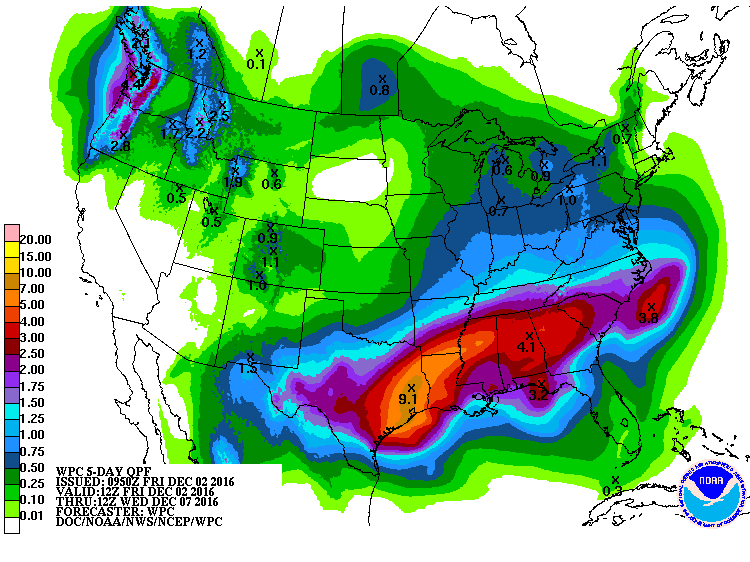
Overall QPF numbers have been increased over the last 24 hours and with widespread amounts of 5-6 inches likely across the entire area and isolated totals of 8 inches or higher. Overnight WPC has increased their 5 day totals to over 9 inches over SE TX which is very concerning given that most of this will fall tonight-Sunday night over in about a 48 hour period. While grounds are dry, rainfall of this magnitude is going to result in considerable run-off and significant rises on area watersheds. Main focus will be along the coastal trough which looks to establish just inland of the coast and possibly along a 850mb front draped over our northern counties.
High moisture levels will certainly support high hourly rainfall rates of 1-3 inches and this will result in street flooding in urban areas.
Flash Flood Watches will likely be required over the weekend.
Tides:
Increasing ENE winds are pushing water toward the coast and coastal flooding is likely this afternoon and overnight. Expect total water levels of 3.5-4.0 ft by late this afternoon which will produce overwash on Bolivar and on the east facing shorelines within Galveston Bay. 4.5 ft is the critical elevation within Galveston Bay to start resulting in widespread coastal flooding…and at this time do not think the tides will get that high…but close.
5 Day Forecasted Rainfall Totals:
Significant rainfall event this weekend….some flooding possible
Coastal Flooding likely this afternoon into Saturday morning
Discussion:
Factors will be in place by late this afternoon to produce a prolonged rainfall events over SE TX this weekend into Monday. A powerful upper level storm system will slowly approach TX today and moisture return is already well under way with mid level moisture pouring into the state from the SW and low level moisture starting to return from the Gulf. Will be watching closely as the coastal trough forms later today on its exact position as this will likely determine where at least one major band of excessive rainfall develops…as early as this evening. Models are all over the place with respect to banding of rainfall and where and breaks if any between large rounds…so will be broadbrush the potential for the entire period from this afternoon through midday Monday. Heavy rainfall will be possible at any time during that period.
Coastal low looks to track up to coast and into SE TX late Sunday along with main dynamics of the upper level system moving across TX at the same time. Warm sector air mass will likely move inland over portions of the area and bring with it a severe weather risk. This is looking more and more like a cool season low CAPE/high shear severe weather threat which can produce low topped supercells. Still fairly far out in time to be certain, but the Sunday night and Monday AM period will need to be watched closely.
Main threat will certainly be the heavy rainfall potential.
Rainfall:
Overall QPF numbers have been increased over the last 24 hours and with widespread amounts of 5-6 inches likely across the entire area and isolated totals of 8 inches or higher. Overnight WPC has increased their 5 day totals to over 9 inches over SE TX which is very concerning given that most of this will fall tonight-Sunday night over in about a 48 hour period. While grounds are dry, rainfall of this magnitude is going to result in considerable run-off and significant rises on area watersheds. Main focus will be along the coastal trough which looks to establish just inland of the coast and possibly along a 850mb front draped over our northern counties.
High moisture levels will certainly support high hourly rainfall rates of 1-3 inches and this will result in street flooding in urban areas.
Flash Flood Watches will likely be required over the weekend.
Tides:
Increasing ENE winds are pushing water toward the coast and coastal flooding is likely this afternoon and overnight. Expect total water levels of 3.5-4.0 ft by late this afternoon which will produce overwash on Bolivar and on the east facing shorelines within Galveston Bay. 4.5 ft is the critical elevation within Galveston Bay to start resulting in widespread coastal flooding…and at this time do not think the tides will get that high…but close.
5 Day Forecasted Rainfall Totals:
0 likes
Carla/Alicia/Jerry(In The Eye)/Michelle/Charley/Ivan/Dennis/Katrina/Rita/Wilma/Ike/Harvey
Member: National Weather Association
Wx Infinity Forums
http://wxinfinity.com/index.php
Facebook.com/WeatherInfinity
Twitter @WeatherInfinity
Member: National Weather Association
Wx Infinity Forums
http://wxinfinity.com/index.php
Facebook.com/WeatherInfinity
Twitter @WeatherInfinity
-
gatorcane

- S2K Supporter
- Posts: 23708
- Age: 48
- Joined: Sun Mar 13, 2005 3:54 pm
- Location: Boca Raton, FL
Re: Texas Winter 2016-2017
Yikes that 00Z ECMWF run is bringing some seriously cold arctic air to Texas and much of the Deep South and Florida. Interesting that the 06Z GFS shifts the core of the cold air east and does not make it deep into Texas like the last couple of GFS runs showed
0 likes
Who is online
Users browsing this forum: Stratton23, TomballEd and 119 guests