Texas Winter 2016-2017
Moderator: S2k Moderators
Forum rules
 The posts in this forum are NOT official forecast and should not be used as such. They are just the opinion of the poster and may or may not be backed by sound meteorological data. They are NOT endorsed by any professional institution or STORM2K.

The posts in this forum are NOT official forecast and should not be used as such. They are just the opinion of the poster and may or may not be backed by sound meteorological data. They are NOT endorsed by any professional institution or STORM2K.
-
Portastorm

- Storm2k Moderator

- Posts: 9954
- Age: 63
- Joined: Fri Jul 11, 2003 9:16 am
- Location: Round Rock, TX
- Contact:
Re: Texas Winter 2016-2017
Well the 12z Euro op run looks very similar and, perhaps, a tad colder for Austin next week. Has us dropping to 27-28 degrees two consecutive nights on 12/8-12/9. That would be the coldest airmass in two years if it verifies.
0 likes
Any forecasts under my name are to be taken with a grain of salt. Get your best forecasts from the National Weather Service and National Hurricane Center.

Re: Texas Winter 2016-2017
TeamPlayersBlue wrote:Ntxw wrote:Near the end of the euro run Nw Canada is even colder than the air mass coming. Lurking Pinwheeling ridge near Alaska.
Little late the the met knowledge party but ive recently noticed that when those Ridges get closed off, they stick around MUCH longer than your 'open' contour ridge
They do, 1983
0 likes
The above post and any post by Ntxw is NOT an official forecast and should not be used as such. It is just the opinion of the poster and may or may not be backed by sound meteorological data. It is NOT endorsed by any professional institution including Storm2k. For official information, please refer to NWS products.
Help support Storm2K!
-
TeamPlayersBlue

- Category 5

- Posts: 3524
- Joined: Tue Feb 02, 2010 1:44 am
- Location: Denver/Applewood, CO
Re: Texas Winter 2016-2017
Ntxw wrote:TeamPlayersBlue wrote:Ntxw wrote:Near the end of the euro run Nw Canada is even colder than the air mass coming. Lurking Pinwheeling ridge near Alaska.
Little late the the met knowledge party but ive recently noticed that when those Ridges get closed off, they stick around MUCH longer than your 'open' contour ridge
They do, 1983
Yep, and a STRONG Aleutian low can help build one of those guys.
0 likes
Personal Forecast Disclaimer:
The posts in this forum are NOT official forecast and should not be used as such. They are just the opinion of the poster and may or may not be backed by sound meteorological data. They are NOT endorsed by any professional institution or storm2k.org. For official information, please refer to the NHC and NWS products.
The posts in this forum are NOT official forecast and should not be used as such. They are just the opinion of the poster and may or may not be backed by sound meteorological data. They are NOT endorsed by any professional institution or storm2k.org. For official information, please refer to the NHC and NWS products.
-
weatherdude1108
- Category 5
- Posts: 4228
- Joined: Tue Dec 13, 2011 1:04 pm
- Location: Northwest Austin/Cedar Park, TX
Re: Texas Winter 2016-2017
Portastorm wrote:Well the 12z Euro op run looks very similar and, perhaps, a tad colder for Austin next week. Has us dropping to 27-28 degrees two consecutive nights on 12/8-12/9. That would be the coldest airmass in two years if it verifies.
Yeah, can't really count last Winter, since it was El Nino, and a blow torch at that. The year without a Winter. I think it got down to 31 at the coldest, once or twice, at my place.
0 likes
The preceding post is NOT an official forecast, and should not be used as such. It is only the opinion of the poster and may or may not be backed by sound meteorological data. It is NOT endorsed by any professional institution including storm2k.org. For Official Information please refer to the NHC and NWS products.
-
TheProfessor

- Professional-Met

- Posts: 3506
- Age: 29
- Joined: Tue Dec 03, 2013 10:56 am
- Location: Wichita, Kansas
Re: Texas Winter 2016-2017
I love the 12z Navgem. I would love for the trough to dig a bit more (a lot more compared to the GFS) and go neutral-neg tilt. Otherwise it's going to be a painful dry cold for me.
0 likes
An alumnus of The Ohio State University.
Your local National Weather Service office is your best source for weather information.
Your local National Weather Service office is your best source for weather information.
-
TheProfessor
- Professional-Met
- Posts: 3506
- Age: 29
- Joined: Tue Dec 03, 2013 10:56 am
- Location: Wichita, Kansas
Re: Texas Winter 2016-2017
Don't know if any of you have heard of Bernie Rayno(works for Acuweather but is more of an East Coast guy) He doesn't think the GFS will be right, but in this video he shows you why the GFS is doing what it's doing as well as the Euro. http://www.accuweather.com/en/videos/ac ... 0839568001
1 likes
An alumnus of The Ohio State University.
Your local National Weather Service office is your best source for weather information.
Your local National Weather Service office is your best source for weather information.
-
gboudx

- S2K Supporter

- Posts: 4090
- Joined: Thu Sep 04, 2003 1:39 pm
- Location: Rockwall, Tx but from Harvey, La
Re: Texas Winter 2016-2017
Good video Professor. I would recommend anyone watching to skip to 2:25 where he starts talking about next week.
1 likes
Re: Texas Winter 2016-2017
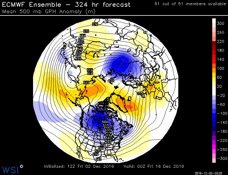
12z Euro ENS supports the OP of blocking near Alaska
0 likes
The above post and any post by Ntxw is NOT an official forecast and should not be used as such. It is just the opinion of the poster and may or may not be backed by sound meteorological data. It is NOT endorsed by any professional institution including Storm2k. For official information, please refer to NWS products.
Help support Storm2K!
Help support Storm2K!
-
ThunderSleetDreams

- S2K Supporter
- Posts: 1510
- Age: 43
- Joined: Tue Dec 20, 2011 4:42 pm
- Location: S of Weimar, TX
Re: Texas Winter 2016-2017
Heyoooo
https://twitter.com/MJVentrice/status/804786578136727552
"Got to <3 this k=2 pattern setting up as a ridge overtakes the North Pole and splits the tropospheric polar vortex into two lobes"
https://twitter.com/MJVentrice/status/804786578136727552
"Got to <3 this k=2 pattern setting up as a ridge overtakes the North Pole and splits the tropospheric polar vortex into two lobes"
Last edited by ThunderSleetDreams on Fri Dec 02, 2016 4:41 pm, edited 1 time in total.
0 likes
#NeverSummer
I hibernate when it gets above 75 degrees!
I hibernate when it gets above 75 degrees!
-
weatherdude1108
- Category 5
- Posts: 4228
- Joined: Tue Dec 13, 2011 1:04 pm
- Location: Northwest Austin/Cedar Park, TX
Re: Texas Winter 2016-2017
TheProfessor wrote:Don't know if any of you have heard of Bernie Rayno(works for Acuweather but is more of an East Coast guy) He doesn't think the GFS will be right, but in this video he shows you why the GFS is doing what it's doing as well as the Euro. http://www.accuweather.com/en/videos/ac ... 0839568001
Good video! It will be interesting to see what pans out. Which model will win?
0 likes
The preceding post is NOT an official forecast, and should not be used as such. It is only the opinion of the poster and may or may not be backed by sound meteorological data. It is NOT endorsed by any professional institution including storm2k.org. For Official Information please refer to the NHC and NWS products.
-
weatherdude1108
- Category 5
- Posts: 4228
- Joined: Tue Dec 13, 2011 1:04 pm
- Location: Northwest Austin/Cedar Park, TX
Re: Texas Winter 2016-2017
There are some technical terms in that third paragraph that are beyond my expertise (Showalters, H850 moisture flux, 300mb wind isotach fields,...), but we get the point.
Hampshire must have written this, or at least helped, but not sure. No name at the end.
http://forecast.weather.gov/product.php ... glossary=0
570
FXUS64 KEWX 022127
AFDEWX
Area Forecast Discussion
National Weather Service Austin/San Antonio TX
327 PM CST Fri Dec 2 2016
.SHORT TERM (Tonight through Monday)...
Periods of light to at times heavy rainfall are expected over the
next 48-72 hours that will result in 3-5 inches of rainfall along
and west of the I-35 corridor. Locally higher amounts near 6
inches could occur in the far SE coastal plains. Rainfall amounts
will decrease east to west from 3 inches central down to 1 inch
towards Rio Grande Plains. Concerns around flash flooding remain low
at this time given modest rainfall rates, dry antecedent
conditions, and overall lack of rainfall concentration in
vulnerable areas over a small timeframe. However, continual
monitoring for training/convective banding, which could be quite
possible, will need to be assessed to determine if this risk
increases.
Isentropic upglide and increasing synoptic ascent from the
digging trough over northern Mexico is aiding the increasingly
moisture laden low- and mid-levels to support widespread light to
moderate showers over the region this afternoon. A few deeper
cores could produce some lightning but MUCAPE values remain
limited /<200 J/KG/ through this evening. The warm front will
stall along just south of San Antonio eastward towards Houston.
Late tonight however, multi-global and multi-hi-res solutions
indicate a shortwave trough ejecting across south-central Texas
that will act to increase deeper moisture flux convergence,
coincident with PWATs increasing into the 1.5-1.7" range and a LLJ
near 30-35 knots with increasing MUCAPE to 500 J/KG and Showalters
tipping negative. These conditions should support an enhanced area
of showers and elevated thunderstorms to overspread the region
from the southwest to the northeast near midnight through mid-day
Saturday. With PWATs 2-3 standard deviations above normal along
with 3-4 above normal H850 moisture flux could lead to localized
moderate to heavy rain across the Hill County and I-35 corridor.
Convective banding or training will need to monitored for as
deeper updraft cores evidence exists in the 300mb wind isotach
fields per convective feedback signals.
By Saturday afternoon and evening, rain showers should be more
scattered and intermittent before another potential wave overnight
Saturday into Sunday morning occurs. Hi-res solutions suggest
another wave of moderate to heavy rain shifting over portions of
the region early Sunday morning. A surface low will develop along
the warm front late Saturday into Sunday that will enhance
rainfall along the coastal plains and the coast. While the
greatest amounts are expected to remain farther east and coastal,
the SE coastal plains could experience heavy rainfall Sunday. WPC
has placed a slight to moderate risk of excessive rainfall just
east of south-central Texas. Farther west, rain showers will
likely again become more scattered and lighter in nature Sunday
morning through the afternoon.
Rain showers and thunderstorms coverage will be on the increase
once again Sunday night into Monday morning as the cut-off low
over Mexico opens up as a wave and pivots over the region.
Rainfall could be moderate a times with this final round as it
clears west to east with drier air filtering in by Monday
afternoon.
&&
.LONG TERM (Tuesday through Friday)...
Main focus mid to late week will center around low-end rain
chances Wednesday and Thursday along and ahead of a strong cold
front. The cold front will bring well below-normal temperatures
as widespread freezing temperatures could be possible Friday and
Saturday morning.
Moisture will attempt to return by Wednesday into Thursday ahead
of a cold front but remain limited to the coastal plains. There
remains some discrepancies in the GFS/EC on overall rain coverage
and it could be expanded farther west on subsequent forecasts.
Temperatures will plunge behind the front with widespread freezing
temperatures expected Friday and Saturday with readings in the
upper 20s to low 30s across most areas with the exception of the
coastal plains and deep Rio Grande Plains.
Hampshire must have written this, or at least helped, but not sure.
http://forecast.weather.gov/product.php ... glossary=0
570
FXUS64 KEWX 022127
AFDEWX
Area Forecast Discussion
National Weather Service Austin/San Antonio TX
327 PM CST Fri Dec 2 2016
.SHORT TERM (Tonight through Monday)...
Periods of light to at times heavy rainfall are expected over the
next 48-72 hours that will result in 3-5 inches of rainfall along
and west of the I-35 corridor. Locally higher amounts near 6
inches could occur in the far SE coastal plains. Rainfall amounts
will decrease east to west from 3 inches central down to 1 inch
towards Rio Grande Plains. Concerns around flash flooding remain low
at this time given modest rainfall rates, dry antecedent
conditions, and overall lack of rainfall concentration in
vulnerable areas over a small timeframe. However, continual
monitoring for training/convective banding, which could be quite
possible, will need to be assessed to determine if this risk
increases.
Isentropic upglide and increasing synoptic ascent from the
digging trough over northern Mexico is aiding the increasingly
moisture laden low- and mid-levels to support widespread light to
moderate showers over the region this afternoon. A few deeper
cores could produce some lightning but MUCAPE values remain
limited /<200 J/KG/ through this evening. The warm front will
stall along just south of San Antonio eastward towards Houston.
Late tonight however, multi-global and multi-hi-res solutions
indicate a shortwave trough ejecting across south-central Texas
that will act to increase deeper moisture flux convergence,
coincident with PWATs increasing into the 1.5-1.7" range and a LLJ
near 30-35 knots with increasing MUCAPE to 500 J/KG and Showalters
tipping negative. These conditions should support an enhanced area
of showers and elevated thunderstorms to overspread the region
from the southwest to the northeast near midnight through mid-day
Saturday. With PWATs 2-3 standard deviations above normal along
with 3-4 above normal H850 moisture flux could lead to localized
moderate to heavy rain across the Hill County and I-35 corridor.
Convective banding or training will need to monitored for as
deeper updraft cores evidence exists in the 300mb wind isotach
fields per convective feedback signals.
By Saturday afternoon and evening, rain showers should be more
scattered and intermittent before another potential wave overnight
Saturday into Sunday morning occurs. Hi-res solutions suggest
another wave of moderate to heavy rain shifting over portions of
the region early Sunday morning. A surface low will develop along
the warm front late Saturday into Sunday that will enhance
rainfall along the coastal plains and the coast. While the
greatest amounts are expected to remain farther east and coastal,
the SE coastal plains could experience heavy rainfall Sunday. WPC
has placed a slight to moderate risk of excessive rainfall just
east of south-central Texas. Farther west, rain showers will
likely again become more scattered and lighter in nature Sunday
morning through the afternoon.
Rain showers and thunderstorms coverage will be on the increase
once again Sunday night into Monday morning as the cut-off low
over Mexico opens up as a wave and pivots over the region.
Rainfall could be moderate a times with this final round as it
clears west to east with drier air filtering in by Monday
afternoon.
&&
.LONG TERM (Tuesday through Friday)...
Main focus mid to late week will center around low-end rain
chances Wednesday and Thursday along and ahead of a strong cold
front. The cold front will bring well below-normal temperatures
as widespread freezing temperatures could be possible Friday and
Saturday morning.
Moisture will attempt to return by Wednesday into Thursday ahead
of a cold front but remain limited to the coastal plains. There
remains some discrepancies in the GFS/EC on overall rain coverage
and it could be expanded farther west on subsequent forecasts.
Temperatures will plunge behind the front with widespread freezing
temperatures expected Friday and Saturday with readings in the
upper 20s to low 30s across most areas with the exception of the
coastal plains and deep Rio Grande Plains.
0 likes
The preceding post is NOT an official forecast, and should not be used as such. It is only the opinion of the poster and may or may not be backed by sound meteorological data. It is NOT endorsed by any professional institution including storm2k.org. For Official Information please refer to the NHC and NWS products.
-
aggiecutter
- Category 5
- Posts: 1755
- Joined: Thu Oct 14, 2004 9:22 pm
- Location: Texarkana
Re: Texas Winter 2016-2017
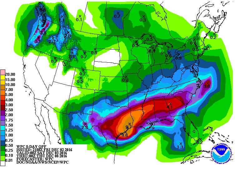
Houston area residents need to keep an eye out for flooding this weekend:

1 likes
Re: Texas Winter 2016-2017
What a great week of weather coming up. Just hope no destructive flooding happens in southeast Texas this weekend. Rain followed by some freezing temps. Snow or not, not a bad way to start December. Call me weird but I can not wait to feel the winter chilled frontal winds blow in my face. Fantastic and invigorating. NWS is calling for wind chills in the teens. 
3 likes
-
starsfan65

- Category 2

- Posts: 738
- Age: 48
- Joined: Thu Dec 17, 2015 1:18 pm
- Location: Garland,Tx
Re: Texas Winter 2016-2017
We are going to have strong winds behind the front Wednesday and Thursday.gpsnowman wrote:What a great week of weather coming up. Just hope no destructive flooding happens in southeast Texas this weekend. Rain followed by some freezing temps. Snow or not, not a bad way to start December. Call me weird but I can not wait to feel the winter chilled frontal winds blow in my face. Fantastic and invigorating. NWS is calling for wind chills in the teens.
0 likes
Re: Texas Winter 2016-2017
ThunderSleetDreams wrote:Heyoooo
https://twitter.com/MJVentrice/status/804786578136727552
"Got to <3 this k=2 pattern setting up as a ridge overtakes the North Pole and splits the tropospheric polar vortex into two lobes"
https://pbs.twimg.com/media/CystH6GXcAAwByQ.jpg
Getting disturbed again up there for December, after being disturbed in November.

1 likes
The above post and any post by Ntxw is NOT an official forecast and should not be used as such. It is just the opinion of the poster and may or may not be backed by sound meteorological data. It is NOT endorsed by any professional institution including Storm2k. For official information, please refer to NWS products.
Help support Storm2K!
Help support Storm2K!

Re: Texas Winter 2016-2017
Ntxw wrote:ThunderSleetDreams wrote:Heyoooo
https://twitter.com/MJVentrice/status/804786578136727552
"Got to <3 this k=2 pattern setting up as a ridge overtakes the North Pole and splits the tropospheric polar vortex into two lobes"
https://pbs.twimg.com/media/CystH6GXcAAwByQ.jpg
Getting disturbed again up there for December, after being disturbed in November.
Ntwx, what is mike ventrice trying to say with what he is referring to? Also, what is this diagram?
0 likes
-
vbhoutex

- Storm2k Executive

- Posts: 29143
- Age: 74
- Joined: Wed Oct 09, 2002 11:31 pm
- Location: Cypress, TX
- Contact:
Re: Texas Winter 2016-2017
Jeff lindner take on SE TX for the weekend. We may need some oars.
Heavy rainfall event likely this weekend which may lead to flooding
Discussion:
Coastal trough is forming off the upper TX coast with scattered showers advancing inland across much of SE TX this evening. Will see a gradual increase in coverage and intensity of rainfall tonight into Saturday with deeper convection and increasing rainfall rates. Radar trends over the Rio Grande plains currently starting to show an increase in returns and some sort of disturbance may be moving out of MX toward TX currently. Short terms models showing some potential for banding and cell training over the area within this extremely moist air mass. Coastal front will back inland starting Saturday with heavier convection likely along this feature and then the meso models show it waffling back and forth over the area into Sunday ahead of the main upper level system.
Point is that heavy rainfall and flooding will be possible from Saturday into Monday.
Rainfall Amounts:
Rainfall amounts have continued to increase today with widespread totals of 5-7 inches or more and isolated amounts of 8-10 inches possible. Should these amounts be realized flooding would be possible, but much of the run-off will be determined on just how fast the rain falls. Think tonight into Saturday will feature modest hourly totals with breaks between batches/bands giving the dry ground time to absorb the rainfall. The concern is Sunday onward when rainfall rates look to increase and the grounds become increasing saturated. Run-off will be maximized by Sunday and this appears to be the favored time when jet stream dynamics when be their strongest favoring higher hourly rainfall rates.
Prolonged nature of the event points toward our northern and western creeks, the San Jacinto system, Cedar Bayou, and Clear Creek as potential issues given that these watersheds take time to drain and prolonged rainfall will gradually add more and more water to these basins. The urban bayous….White Oak, Brays, Buffalo tend to be more vulnerable to the high intensity short duration rainfall rates instead of the spread out lighter rates. With the uncertainty on when and where higher rates may occur under any training bands it is hard to say with any area has a higher flooding threat than another. Feel most watersheds should be able to handle 5 inches...after that concern would be increasing.
Severe Threat:
Have not spent much time on this with the primary threat rainfall and flooding, but there will be a threat especially Sunday into Monday as the warm sector moves inland and shear and dynamics increase. Main threat would appear to be wind damage and maybe an isolated tornado in low topped supercells.
Tides:
Total water levels running about 1.0-1.5 ft this evening…with stiff ENE winds now in place across the upper TX coast. Water levels forecast to push to near 3.5 ft on Saturday as ENE winds continue to pile water on the coast and wave heights gradually rise. Could see some overwash in the typical vulnerable areas on the west side of the bay and on Bolivar.
HCFCD:
The Clear Creek Outlet Gates were opened this evening and will remain opened at least into Monday.
1 likes
Skywarn, C.E.R.T.
Please click below to donate to STORM2K to help with the expenses of keeping the site going:

Please click below to donate to STORM2K to help with the expenses of keeping the site going:
-
StormShelter
- Tropical Wave

- Posts: 1
- Joined: Sun Nov 13, 2016 8:18 pm
Re: Texas Winter 2016-2017
We sure are enjoying reading all of this material. There is wealth of it in here! I don't think we will have much to offer as we are just storm shelter manufacturers, but this is still very helpful to us. Thanks for all that you all do!
http://www.tornadoshelter.com
http://www.tornadoshelter.com
0 likes
-
TeamPlayersBlue
- Category 5
- Posts: 3524
- Joined: Tue Feb 02, 2010 1:44 am
- Location: Denver/Applewood, CO
Re: Texas Winter 2016-2017
Somewhere in SE Tx, someone getting a foot of rain im sure. I just looked at the HRRR though, Central Tx is going to get SWAMPED overnight tonight
0 likes
Personal Forecast Disclaimer:
The posts in this forum are NOT official forecast and should not be used as such. They are just the opinion of the poster and may or may not be backed by sound meteorological data. They are NOT endorsed by any professional institution or storm2k.org. For official information, please refer to the NHC and NWS products.
The posts in this forum are NOT official forecast and should not be used as such. They are just the opinion of the poster and may or may not be backed by sound meteorological data. They are NOT endorsed by any professional institution or storm2k.org. For official information, please refer to the NHC and NWS products.
Who is online
Users browsing this forum: Brent, Google [Bot] and 43 guests