Texas Winter 2016-2017

Winter Weather Discussion

Moderator: S2k Moderators

Forum rules

The posts in this forum are NOT official forecast and should not be used as such. They are just the opinion of the poster and may or may not be backed by sound meteorological data. They are NOT endorsed by any professional institution or STORM2K.

Help Support Storm2K
Message
Author
User avatar
Ntxw
Storm2k Moderator
Storm2k Moderator
Posts: 22787
Joined: Wed Oct 21, 2009 6:34 pm
Location: DFW, Texas

Re: Texas Winter 2016-2017

#3521 Postby Ntxw » Mon Jan 09, 2017 8:23 pm

Ntxw wrote:The coming NPO ridge is more potent than the ridge that set up early to mid December. I wish I could find a good hovmoller depiction from the GFS or it's ensembles. It's quite useful for ENSO, I bet it would be for the mid and high latitudes too. But for now Mike Ventrice has a good one for the ECMWF

The ridges are the red blobs. The area of the Pacific is about the middle in the image which is close to 180 degrees longitude/dateline
https://twitter.com/MJVentrice/status/8 ... 5389571073

There's also the Greenland area that will see some ridging too


Bump follow up post. Prediction was very good and produced one of the more memorable cold blasts of recent years. Now the Pacific will flip to +EPO and the exact opposite pattern commence. Courtesy of Dr. Mike Ventrice

Image
0 likes   
The above post and any post by Ntxw is NOT an official forecast and should not be used as such. It is just the opinion of the poster and may or may not be backed by sound meteorological data. It is NOT endorsed by any professional institution including Storm2k. For official information, please refer to NWS products.

  Help support Storm2K!
Help Support Storm2K

Golf7070
Tropical Storm
Tropical Storm
Posts: 115
Joined: Sun Oct 30, 2016 8:58 pm

Re: Texas Winter 2016-2017

#3522 Postby Golf7070 » Mon Jan 09, 2017 9:36 pm

Ntxw, I have two things I'm wondering about. What is the readings for today with laniña? Didn't see it posted. Also, I don't think we want to see that strong of a +pna I don't think. Last thing.... Why is it going to warm up so much coming up and why are alot of people thinking Feb could be colder?
0 likes   

User avatar
TheProfessor
Professional-Met
Professional-Met
Posts: 3506
Age: 28
Joined: Tue Dec 03, 2013 10:56 am
Location: Wichita, Kansas

Re: Texas Winter 2016-2017

#3523 Postby TheProfessor » Mon Jan 09, 2017 9:55 pm

0z Nam is coming in a little colder, seems to advance the Cold front faster too, It has DFW at 55 degrees at hour 78 instead of 57 that the 18z had. 78 is still the NAM's fantasy range though.
0 likes   
An alumnus of The Ohio State University.

Your local National Weather Service office is your best source for weather information.

Brent
S2K Supporter
S2K Supporter
Posts: 38095
Age: 37
Joined: Sun May 16, 2004 10:30 pm
Location: Tulsa Oklahoma
Contact:

Re: Texas Winter 2016-2017

#3524 Postby Brent » Mon Jan 09, 2017 10:38 pm

TheProfessor wrote:0z Nam is coming in a little colder, seems to advance the Cold front faster too, It has DFW at 55 degrees at hour 78 instead of 57 that the 18z had. 78 is still the NAM's fantasy range though.


Ice is not far away from DFW Friday (Edit I just noticed these maps now say "includes sleet" after the debacle east of here last weekend :lol: )

Image
0 likes   
#neversummer

User avatar
Ptarmigan
Category 5
Category 5
Posts: 5313
Joined: Wed Aug 16, 2006 9:06 pm

Re: Texas Winter 2016-2017

#3525 Postby Ptarmigan » Mon Jan 09, 2017 11:15 pm

Ntxw wrote:We had an up and down winter like this in 1995-1996. 90s and single digits. Fwiw NAM late in the run is pushing the front through. HP is a little further west than GFS, raining pretty good


1995-1996 was a rather interesting winter. It was a La Nina winter. The previous winter, 1994-1995 was El Nino.
0 likes   

User avatar
SnowintheFalls
S2K Supporter
S2K Supporter
Posts: 274
Age: 47
Joined: Fri Nov 22, 2013 5:06 pm
Location: Burkburnett, TX

Re: Texas Winter 2016-2017

#3526 Postby SnowintheFalls » Mon Jan 09, 2017 11:17 pm

0Z GFS keeps the freezing precipitation line confined to the northern most part of the Panhandle.
0 likes   
There is no day like a snow day!

User avatar
Ptarmigan
Category 5
Category 5
Posts: 5313
Joined: Wed Aug 16, 2006 9:06 pm

Re: Texas Winter 2016-2017

#3527 Postby Ptarmigan » Mon Jan 09, 2017 11:18 pm

wxman57 wrote:
gatorcane wrote:12Z Euro ends with a blow torch over most of the United States and Southern Canada:

https://s28.postimg.org/wfbhh8pcd/ecmwf_T850a_us_11.png


I definitely believe that forecast! GFS is similar for that time frame, but has cold air returning by the 24th. I believe the 10-day forecast but not the 16-day. ;-)

http://www.tropicaltidbits.com/analysis ... _us_44.png

http://www.tropicaltidbits.com/analysis ... _us_53.png


I will take the 384 hour over the 276 hours any day. :grrr:
0 likes   

Yukon Cornelius
S2K Supporter
S2K Supporter
Posts: 1798
Age: 41
Joined: Thu Dec 20, 2012 9:23 pm
Location: Dean, TX/Westcliffe, CO

Re: Texas Winter 2016-2017

#3528 Postby Yukon Cornelius » Mon Jan 09, 2017 11:37 pm

Talk about a back and forth forecast from the NWS. Ice forecasted then 6 hours later, rain. 6 hours later, back to Ice then another 6 hours, back to rain. Back and forth, and back and forth. Crazy.
0 likes   
#neversummer

User avatar
bubba hotep
S2K Supporter
S2K Supporter
Posts: 5837
Joined: Wed Dec 28, 2016 1:00 am
Location: Collin County Texas

Re: Texas Winter 2016-2017

#3529 Postby bubba hotep » Mon Jan 09, 2017 11:57 pm

Ntxw wrote:I am really looking forward to Feb. The Euro weeklies helped solidify what a lot of other longer range guidance is hinting. The early part of the month looks like the pattern of stormy, cooler Febs. I'm not a huge fan of the +PNA but with a weakening La Nada undercutting the western ridge could work for us with a southern stream. Lots of warmth to go through before the end of the month though.

But if we can build up +rain anomalies during the milder period it's a lot better than warm and dry


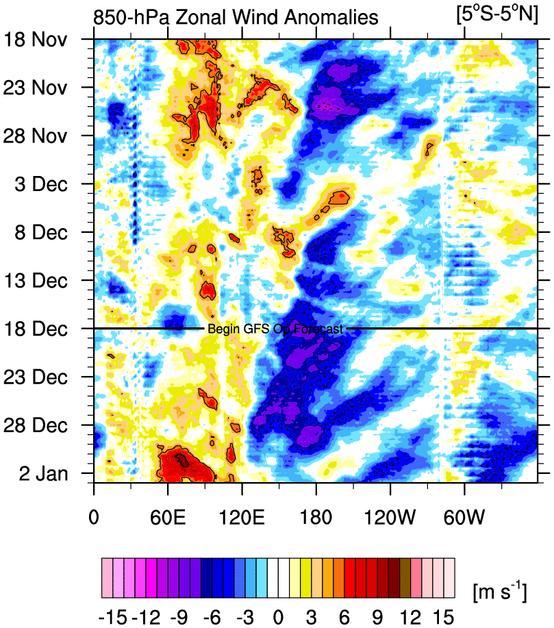
I haven't been very impressed with the Euro weeklies here lately. There is another Pacific jet extension coming and we'll have to get through that before another -EPO dump can come around but that has been the pattern. A +PNA during a PJE can teleconnect to enhanced convection in the western Pacific, so that might be why some of the models are trying to kick off the MJO.

Image

With SSTs trending ENSO neutral then maybe something like a coherent MJO could help shake up the background state that is still pretty Nina looking and forecast to stay that way for a bit longer

Image

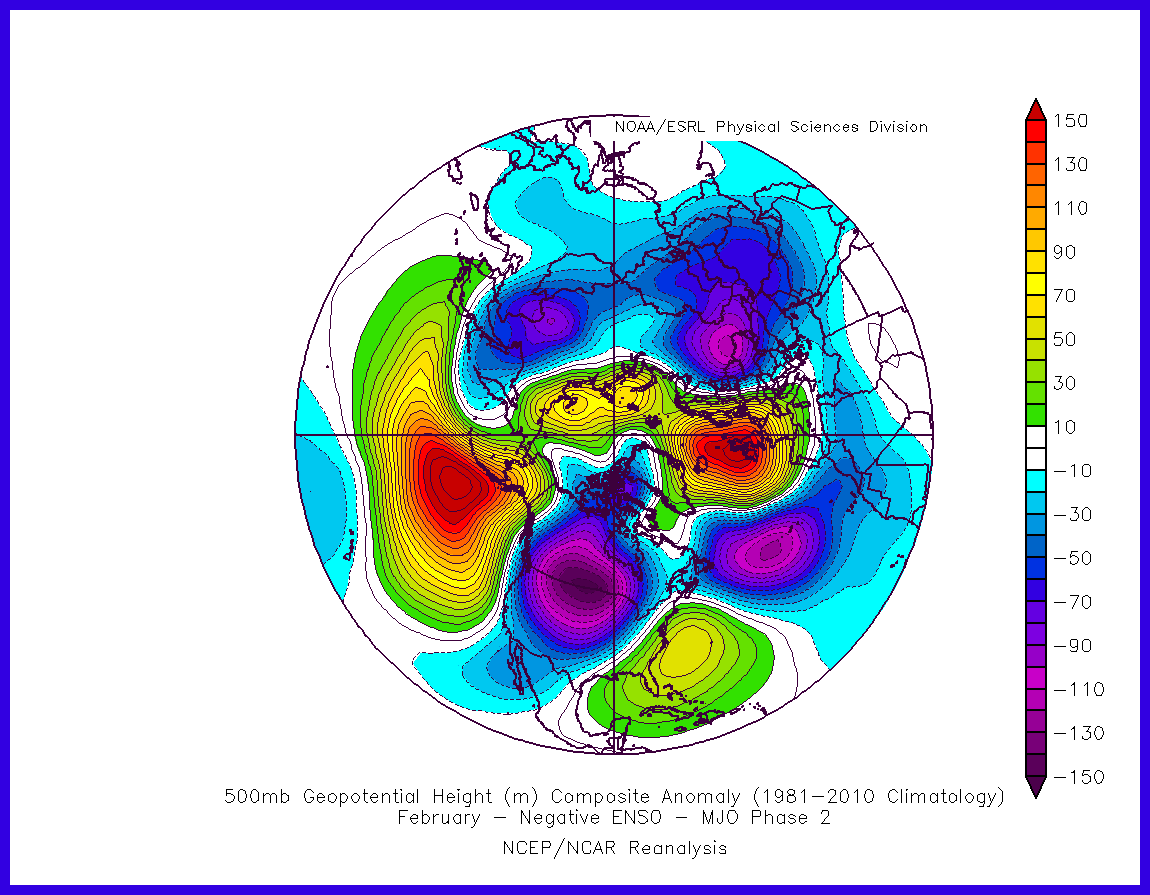
Once the PJE retracts then there should be another round of -EPO cold but to what extent? Also, if there is an MJO and it can get into Phase 2 then that might look like something like this in Feb with the current background state

Image
0 likes   
Winter time post are almost exclusively focused on the DFW area.

Brent
S2K Supporter
S2K Supporter
Posts: 38095
Age: 37
Joined: Sun May 16, 2004 10:30 pm
Location: Tulsa Oklahoma
Contact:

Re: Texas Winter 2016-2017

#3530 Postby Brent » Tue Jan 10, 2017 1:33 am

Euro is 20 degrees colder Saturday at DFW this run... it's still well above freezing, but interesting nonetheless.

It has the ice storm still in OKC Friday and Saturday before warming up Sunday. Wichita Falls gets close briefly but stays just above freezing.
0 likes   
#neversummer

User avatar
Portastorm
Storm2k Moderator
Storm2k Moderator
Posts: 9914
Age: 63
Joined: Fri Jul 11, 2003 9:16 am
Location: Round Rock, TX
Contact:

Re: Texas Winter 2016-2017

#3531 Postby Portastorm » Tue Jan 10, 2017 7:33 am

Based on all the overnight models, it looks like quite the rain event for Texas this weekend. I know aggiecutter's area of Texas needs rain bad. And for the rest of us, never sniff at a winter rain event which can bring down 2-3" over a weekend. Liquid gold!
2 likes   
Any forecasts under my name are to be taken with a grain of salt. Get your best forecasts from the National Weather Service and National Hurricane Center.

User avatar
CaptinCrunch
S2K Supporter
S2K Supporter
Posts: 8728
Age: 57
Joined: Mon Nov 03, 2003 4:33 pm
Location: Kennedale, TX (Tarrant Co.)

Re: Texas Winter 2016-2017

#3532 Postby CaptinCrunch » Tue Jan 10, 2017 9:17 am

Last night one of our local wx forecasters kinda explained why the forecast changes so much on a giving storm system. Basically this coming system is still off the western seaboard, so all forecast are strictly model driven minus the soundings. As the storm system comes on shore air soundings can be collected and the fine tuning of the forecast can began. So she goes on to say right now we will continue to see changes to the forecast and nothing has been ruled out at this time. Stay tuned....lol
0 likes   

Yukon Cornelius
S2K Supporter
S2K Supporter
Posts: 1798
Age: 41
Joined: Thu Dec 20, 2012 9:23 pm
Location: Dean, TX/Westcliffe, CO

Re: Texas Winter 2016-2017

#3533 Postby Yukon Cornelius » Tue Jan 10, 2017 9:25 am

CaptinCrunch wrote:Last night one of our local wx forecasters kinda explained why the forecast changes so much on a giving storm system. Basically this coming system is still off the western seaboard, so all forecast are strictly model driven minus the soundings. As the storm system comes on shore air soundings can be collected and the fine tuning of the forecast can began. So she goes on to say right now we will continue to see changes to the forecast and nothing has been ruled out at this time. Stay tuned....lol

That's pretty much what I thought. I started noticing that the NOAA forecast changed and is updated with every new model run. Even though they have taken the ice threat away as of now I'm assuming they don't want us to write it off just yet due to the fact that we keep being issued a special weather statement each morning regarding the possibility.
0 likes   
#neversummer

WeatherGuesser
Category 5
Category 5
Posts: 2672
Joined: Tue Jun 29, 2010 6:46 am

Re: Texas Winter 2016-2017

#3534 Postby WeatherGuesser » Tue Jan 10, 2017 9:29 am

Portastorm wrote:Based on all the overnight models, it looks like quite the rain event for Texas this weekend. I know aggiecutter's area of Texas needs rain bad. And for the rest of us, never sniff at a winter rain event which can bring down 2-3" over a weekend. Liquid gold!


Depends if it soaks in or runs off. How are the lakes? Still full or did they drop enough to take a heavy rain?
0 likes   

User avatar
Portastorm
Storm2k Moderator
Storm2k Moderator
Posts: 9914
Age: 63
Joined: Fri Jul 11, 2003 9:16 am
Location: Round Rock, TX
Contact:

Re: Texas Winter 2016-2017

#3535 Postby Portastorm » Tue Jan 10, 2017 9:39 am

WeatherGuesser wrote:
Portastorm wrote:Based on all the overnight models, it looks like quite the rain event for Texas this weekend. I know aggiecutter's area of Texas needs rain bad. And for the rest of us, never sniff at a winter rain event which can bring down 2-3" over a weekend. Liquid gold!


Depends if it soaks in or runs off. How are the lakes? Still full or did they drop enough to take a heavy rain?


The Highland Lakes are close to full but not full ... so they could easily take several inches of rainfall this weekend. Those of us in Texas learned after the brutal, horrific year of 2011 (and its associated drought) that we will take rain whenever we can get it. Some areas of north and especially northeast Texas are in moderate/severe drought conditions again. Here is a graphic:
Imagephoto hosting sites
2 likes   
Any forecasts under my name are to be taken with a grain of salt. Get your best forecasts from the National Weather Service and National Hurricane Center.

Snowman67
Category 2
Category 2
Posts: 633
Joined: Thu Dec 31, 2009 12:44 pm
Location: Tomball, TX

Re: Texas Winter 2016-2017

#3536 Postby Snowman67 » Tue Jan 10, 2017 9:43 am

I have a feeling that Wxman57 is sitting at the controls laughing like a mad scientist as he turns the continent into a blow torch over the next several days.
0 likes   
Any forecast I make is based on my opinion only. Please refer to the NWS or NHC for official forecasts.

User avatar
wxman57
Moderator-Pro Met
Moderator-Pro Met
Posts: 22980
Age: 67
Joined: Sat Jun 21, 2003 8:06 pm
Location: Houston, TX (southwest)

Re: Texas Winter 2016-2017

#3537 Postby wxman57 » Tue Jan 10, 2017 10:03 am

Snowman67 wrote:I have a feeling that Wxman57 is sitting at the controls laughing like a mad scientist as he turns the continent into a blow torch over the next several days.

More chuckling than laughing... :firedevil:

I notice that we gain 30 minutes more sunlight in January, 45 minutes in February, and an hour more sunlight in March. The sun is getting higher in the sky each day. I'm fairly sure we've seen the coldest that this winter has to offer (at least I hope so!). Time to start thinking about spring. I see a couple of nice, warm cycling days ahead this weekend.
0 likes   

weatherdude1108
Category 5
Category 5
Posts: 4228
Joined: Tue Dec 13, 2011 1:04 pm
Location: Northwest Austin/Cedar Park, TX

Re: Texas Winter 2016-2017

#3538 Postby weatherdude1108 » Tue Jan 10, 2017 10:21 am

Portastorm wrote:
WeatherGuesser wrote:
Portastorm wrote:Based on all the overnight models, it looks like quite the rain event for Texas this weekend. I know aggiecutter's area of Texas needs rain bad. And for the rest of us, never sniff at a winter rain event which can bring down 2-3" over a weekend. Liquid gold!


Depends if it soaks in or runs off. How are the lakes? Still full or did they drop enough to take a heavy rain?


The Highland Lakes are close to full but not full ... so they could easily take several inches of rainfall this weekend. Those of us in Texas learned after the brutal, horrific year of 2011 (and its associated drought) that we will take rain whenever we can get it. Some areas of north and especially northeast Texas are in moderate/severe drought conditions again. Here is a graphic:
https://s19.postimg.org/g08y7nw9v/20170103_TX_trd.pngphoto hosting sites


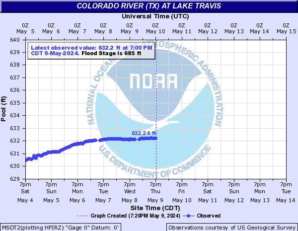
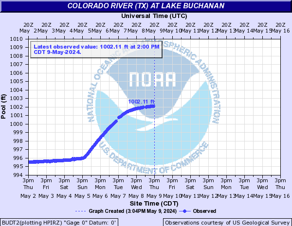
Lake Travis is currently just within its "Action Stage" elevation (almost 683 feet). Travis is full at 681 feet. Lake Buchanan is "full" at 1018 or 1021 feet, depending on the time of year (set by LCRA). They are keeping it at 1018 to do dam upgrades at Buchanan. Right now Buchanan's water level is around 1018 feet. Here are the graphics from Advanced Hydrologic Prediction Service (http://water.weather.gov/ahps2/hydrogra ... hydrograph):
Image
Image
0 likes   
The preceding post is NOT an official forecast, and should not be used as such. It is only the opinion of the poster and may or may not be backed by sound meteorological data. It is NOT endorsed by any professional institution including storm2k.org. For Official Information please refer to the NHC and NWS products.

User avatar
CaptinCrunch
S2K Supporter
S2K Supporter
Posts: 8728
Age: 57
Joined: Mon Nov 03, 2003 4:33 pm
Location: Kennedale, TX (Tarrant Co.)

Re: Texas Winter 2016-2017

#3539 Postby CaptinCrunch » Tue Jan 10, 2017 11:11 am

Image
A large, slow moving upper level low and a cold front will bring a chance for rain to the region late this week and this weekend. The best rain chances are Sunday and Sunday night. At this time, the greatest threats are several bouts of showers with isolated thunderstorms. In addition, localized heavy rainfall are possible later in the weekend into Monday morning. Main stem river flooding, along with localized flash flooding cannot be ruled out during late weekend into early Monday time frame. We are still assessing if there is a threat for any winter weather or severe weather, but at this time the threats for both appear very low. This system remains several days out and there will likely be changes to the forecast, so stay tuned for the latest information regarding the late week and weekend storm system.
0 likes   

Yukon Cornelius
S2K Supporter
S2K Supporter
Posts: 1798
Age: 41
Joined: Thu Dec 20, 2012 9:23 pm
Location: Dean, TX/Westcliffe, CO

Re: Texas Winter 2016-2017

#3540 Postby Yukon Cornelius » Tue Jan 10, 2017 11:14 am

Image
0 likes   
#neversummer


Return to “Winter Weather”

Who is online

Users browsing this forum: No registered users and 5 guests