Texas Winter 2016-2017

Winter Weather Discussion

Moderator: S2k Moderators

Forum rules

The posts in this forum are NOT official forecast and should not be used as such. They are just the opinion of the poster and may or may not be backed by sound meteorological data. They are NOT endorsed by any professional institution or STORM2K.

Help Support Storm2K
Message
Author
User avatar
vbhoutex
Storm2k Executive
Storm2k Executive
Posts: 29113
Age: 73
Joined: Wed Oct 09, 2002 11:31 pm
Location: Cypress, TX
Contact:

Re: Texas Winter 2016-2017

#4121 Postby vbhoutex » Thu Jan 26, 2017 9:52 am

wxman57 wrote:It still looks like some cold air may slip out of Canada by the 2nd week of February. My coworker and I were discussing it yesterday. There is at least a chance that temps in Houston could get down below freezing with this cold push. Nothing to indicate it will be as cold as in the first week of January. Temps below normal (normal is 44/65 here) but nothing nearly as extreme as the low of 21 earlier this month. Perhaps this will be winter's last gasp before the real warm-up for spring.

:froze: :cold: :roll: :yow: :thermo:
0 likes   
Skywarn, C.E.R.T.
Please click below to donate to STORM2K to help with the expenses of keeping the site going:
Image

Ralph's Weather
S2K Supporter
S2K Supporter
Posts: 3269
Age: 38
Joined: Fri Dec 13, 2013 11:55 am
Location: Lindale, TX
Contact:

Re: Texas Winter 2016-2017

#4122 Postby Ralph's Weather » Thu Jan 26, 2017 10:39 am

Made it down to 31 here this morning.
0 likes   
Follow on Facebook at Ralph's Weather.

User avatar
wxman57
Moderator-Pro Met
Moderator-Pro Met
Posts: 22979
Age: 67
Joined: Sat Jun 21, 2003 8:06 pm
Location: Houston, TX (southwest)

Re: Texas Winter 2016-2017

#4123 Postby wxman57 » Thu Jan 26, 2017 11:31 am

By the way, my cold-mongering coworker is talking about snow in Houston on Saturday. There's a shallow layer of sub-freezing moisture above 700mb (10,000ft) that could produce snow. However, the atmosphere is very dry below 10,000 ft, meaning the snow would most likely not reach the ground. You could look up and see it snowing around 10-12 thousand feet up, though.
0 likes   

User avatar
Ntxw
Storm2k Moderator
Storm2k Moderator
Posts: 22786
Joined: Wed Oct 21, 2009 6:34 pm
Location: DFW, Texas

Re: Texas Winter 2016-2017

#4124 Postby Ntxw » Thu Jan 26, 2017 11:43 am

GFS and GEFS is caving to EPS. Progressing Aleutian block to Alaska vs retrograding. Would be big dump of cold should that happen next weekend.
0 likes   
The above post and any post by Ntxw is NOT an official forecast and should not be used as such. It is just the opinion of the poster and may or may not be backed by sound meteorological data. It is NOT endorsed by any professional institution including Storm2k. For official information, please refer to NWS products.

  Help support Storm2K!
Help Support Storm2K

User avatar
wxman57
Moderator-Pro Met
Moderator-Pro Met
Posts: 22979
Age: 67
Joined: Sat Jun 21, 2003 8:06 pm
Location: Houston, TX (southwest)

Re: Texas Winter 2016-2017

#4125 Postby wxman57 » Thu Jan 26, 2017 12:01 pm

Ntxw wrote:GFS and GEFS is caving to EPS. Progressing Aleutian block to Alaska vs retrograding. Would be big dump of cold should that happen next weekend.


GFS has that first shot of cold air tracking east-southeast to the Great Lakes and SE Canada. It does indicate another cold shot coming south after the 10th. Good thing we can't trust he GFS out that far...
0 likes   

User avatar
Ntxw
Storm2k Moderator
Storm2k Moderator
Posts: 22786
Joined: Wed Oct 21, 2009 6:34 pm
Location: DFW, Texas

Re: Texas Winter 2016-2017

#4126 Postby Ntxw » Thu Jan 26, 2017 12:10 pm

wxman57 wrote:
Ntxw wrote:GFS and GEFS is caving to EPS. Progressing Aleutian block to Alaska vs retrograding. Would be big dump of cold should that happen next weekend.


GFS has that first shot of cold air tracking east-southeast to the Great Lakes and SE Canada. It does indicate another cold shot coming south after the 10th. Good thing we can't trust he GFS out that far...


Yes sir. 500mb is the best to look at first. GFS often can see the upper pattern but is poor at the lower levels long range. Prime example early Jan outbreak when it hardly had a freeze for DFW...we know how that turned out. I still favor the 1989 Feb analog. Perhaps not to that magnitude but similar flow. Possibly teens for lows at DFW and upper 20s for Houston again if I had to make an educated guess.
2 likes   
The above post and any post by Ntxw is NOT an official forecast and should not be used as such. It is just the opinion of the poster and may or may not be backed by sound meteorological data. It is NOT endorsed by any professional institution including Storm2k. For official information, please refer to NWS products.


  Help support Storm2K!

Help Support Storm2K


User avatar
wxman57
Moderator-Pro Met
Moderator-Pro Met
Posts: 22979
Age: 67
Joined: Sat Jun 21, 2003 8:06 pm
Location: Houston, TX (southwest)

Re: Texas Winter 2016-2017

#4127 Postby wxman57 » Thu Jan 26, 2017 12:36 pm

Ntxw wrote:
wxman57 wrote:
Ntxw wrote:GFS and GEFS is caving to EPS. Progressing Aleutian block to Alaska vs retrograding. Would be big dump of cold should that happen next weekend.


GFS has that first shot of cold air tracking east-southeast to the Great Lakes and SE Canada. It does indicate another cold shot coming south after the 10th. Good thing we can't trust he GFS out that far...


Yes sir. 500mb is the best to look at first. GFS often can see the upper pattern but is poor at the lower levels long range. Prime example early Jan outbreak when it hardly had a freeze for DFW...we know how that turned out. I still favor the 1989 Feb analog. Perhaps not to that magnitude but similar flow. Possibly teens for lows at DFW and upper 20s for Houston again if I had to make an educated guess.


That is true, assuming it can get the 500mb pattern right. Personally, I favor the 1986 analog, the one with 90-deg temps in Houston. ;-)
0 likes   

User avatar
TeamPlayersBlue
Category 5
Category 5
Posts: 3445
Joined: Tue Feb 02, 2010 1:44 am
Location: Denver/Applewood, CO

Re: Texas Winter 2016-2017

#4128 Postby TeamPlayersBlue » Thu Jan 26, 2017 12:40 pm

Record setting snow in CO and i pick the ONE week where they arent forecasting any snow.
0 likes   
Personal Forecast Disclaimer:
The posts in this forum are NOT official forecast and should not be used as such. They are just the opinion of the poster and may or may not be backed by sound meteorological data. They are NOT endorsed by any professional institution or storm2k.org. For official information, please refer to the NHC and NWS products.

User avatar
Ntxw
Storm2k Moderator
Storm2k Moderator
Posts: 22786
Joined: Wed Oct 21, 2009 6:34 pm
Location: DFW, Texas

Re: Texas Winter 2016-2017

#4129 Postby Ntxw » Thu Jan 26, 2017 12:48 pm

TeamPlayersBlue wrote:Record setting snow in CO and i pick the ONE week where they arent forecasting any snow.


Bad timing with the only real +PNA period of the winter. NW flow stinks for snow.
0 likes   
The above post and any post by Ntxw is NOT an official forecast and should not be used as such. It is just the opinion of the poster and may or may not be backed by sound meteorological data. It is NOT endorsed by any professional institution including Storm2k. For official information, please refer to NWS products.


  Help support Storm2K!

Help Support Storm2K


User avatar
Ntxw
Storm2k Moderator
Storm2k Moderator
Posts: 22786
Joined: Wed Oct 21, 2009 6:34 pm
Location: DFW, Texas

Re: Texas Winter 2016-2017

#4130 Postby Ntxw » Thu Jan 26, 2017 1:09 pm

In retrospect (after looking at winter of 1988-1989) overall it seems that winter to date has been a solid analog. December for this year and that year averaged pretty close 49.7 and 49.1 respectfully. Jan that year averaged 50, this Jan is sitting at 51. Both years featured very positive AO, and had sharp, short cold spells during Pacific jet retraction. The coldest month that year was Feb which averaged near 42F while the snowiest month was March at DFW. We'll see if it holds to form, I had disregarded last fall this analog because the Nina is nowhere near the very strong 1988-1989 Nina. But you can never disregard the response in the atmosphere often is not always 1:1 with the ocean.
0 likes   
The above post and any post by Ntxw is NOT an official forecast and should not be used as such. It is just the opinion of the poster and may or may not be backed by sound meteorological data. It is NOT endorsed by any professional institution including Storm2k. For official information, please refer to NWS products.


  Help support Storm2K!

Help Support Storm2K


User avatar
bubba hotep
S2K Supporter
S2K Supporter
Posts: 5837
Joined: Wed Dec 28, 2016 1:00 am
Location: Collin County Texas

Re: Texas Winter 2016-2017

#4131 Postby bubba hotep » Thu Jan 26, 2017 1:38 pm

Ntxw wrote:In retrospect (after looking at winter of 1988-1989) overall it seems that winter to date has been a solid analog. December for this year and that year averaged pretty close 49.7 and 49.1 respectfully. Jan that year averaged 50, this Jan is sitting at 51. Both years featured very positive AO, and had sharp, short cold spells during Pacific jet retraction. The coldest month that year was Feb which averaged near 42F while the snowiest month was March at DFW. We'll see if it holds to form, I had disregarded last fall this analog because the Nina is nowhere near the very strong 1988-1989 Nina. But you can never disregard the response in the atmosphere often is not always 1:1 with the ocean.


The atmospheric response did seem more impressive than would've been expected and has has me wondering if the models are breaking that pattern down too fast. Both the Euro EPS and GEFS are taking on a more ENSO neutral looks in the longer range. I certainly wouldn't mind that, N. Texas would have more chances at winter weather with an active flow with cold on top vs. the more nina like dry cold blast then warm up pattern that we've seen so far this winter.
0 likes   
Winter time post are almost exclusively focused on the DFW area.

User avatar
Portastorm
Storm2k Moderator
Storm2k Moderator
Posts: 9914
Age: 63
Joined: Fri Jul 11, 2003 9:16 am
Location: Round Rock, TX
Contact:

Re: Texas Winter 2016-2017

#4132 Postby Portastorm » Thu Jan 26, 2017 2:16 pm

Ntxw wrote:In retrospect (after looking at winter of 1988-1989) overall it seems that winter to date has been a solid analog. December for this year and that year averaged pretty close 49.7 and 49.1 respectfully. Jan that year averaged 50, this Jan is sitting at 51. Both years featured very positive AO, and had sharp, short cold spells during Pacific jet retraction. The coldest month that year was Feb which averaged near 42F while the snowiest month was March at DFW. We'll see if it holds to form, I had disregarded last fall this analog because the Nina is nowhere near the very strong 1988-1989 Nina. But you can never disregard the response in the atmosphere often is not always 1:1 with the ocean.


Your analog doesn't hold up down here in this part of Texas. For December it works as the average mean temp in 12/88 was 55.5 while for 12/16 it was 54.8, a difference of 0.7 degrees. But for January, in 01/89 the average mean was 55.3 and the current one for 01/17 is 57.2. Much, much warmer this January as compared to 1989.
0 likes   
Any forecasts under my name are to be taken with a grain of salt. Get your best forecasts from the National Weather Service and National Hurricane Center.

User avatar
South Texas Storms
Professional-Met
Professional-Met
Posts: 4227
Joined: Thu Jun 24, 2010 12:28 am
Location: Houston, TX

Re: Texas Winter 2016-2017

#4133 Postby South Texas Storms » Thu Jan 26, 2017 2:35 pm

12z Euro shows a very cold air mass building in western Canada at the end of the run.
0 likes   

User avatar
Ntxw
Storm2k Moderator
Storm2k Moderator
Posts: 22786
Joined: Wed Oct 21, 2009 6:34 pm
Location: DFW, Texas

Re: Texas Winter 2016-2017

#4134 Postby Ntxw » Thu Jan 26, 2017 2:43 pm

Portastorm wrote:
Ntxw wrote:In retrospect (after looking at winter of 1988-1989) overall it seems that winter to date has been a solid analog. December for this year and that year averaged pretty close 49.7 and 49.1 respectfully. Jan that year averaged 50, this Jan is sitting at 51. Both years featured very positive AO, and had sharp, short cold spells during Pacific jet retraction. The coldest month that year was Feb which averaged near 42F while the snowiest month was March at DFW. We'll see if it holds to form, I had disregarded last fall this analog because the Nina is nowhere near the very strong 1988-1989 Nina. But you can never disregard the response in the atmosphere often is not always 1:1 with the ocean.


Your analog doesn't hold up down here in this part of Texas. For December it works as the average mean temp in 12/88 was 55.5 while for 12/16 it was 54.8, a difference of 0.7 degrees. But for January, in 01/89 the average mean was 55.3 and the current one for 01/17 is 57.2. Much, much warmer this January as compared to 1989.


Its been warmer this January overall for everyone. The idea is though 1988-1989 overall warmer winter with bouts of shorter, sharp cold periods. It worked closer than the colder weak Ninas such as 1983-1984. So behavior of the winter is closer to the more solid Nina patterns despite being a weak Nina
0 likes   
The above post and any post by Ntxw is NOT an official forecast and should not be used as such. It is just the opinion of the poster and may or may not be backed by sound meteorological data. It is NOT endorsed by any professional institution including Storm2k. For official information, please refer to NWS products.


  Help support Storm2K!

Help Support Storm2K


User avatar
bubba hotep
S2K Supporter
S2K Supporter
Posts: 5837
Joined: Wed Dec 28, 2016 1:00 am
Location: Collin County Texas

Re: Texas Winter 2016-2017

#4135 Postby bubba hotep » Thu Jan 26, 2017 2:49 pm

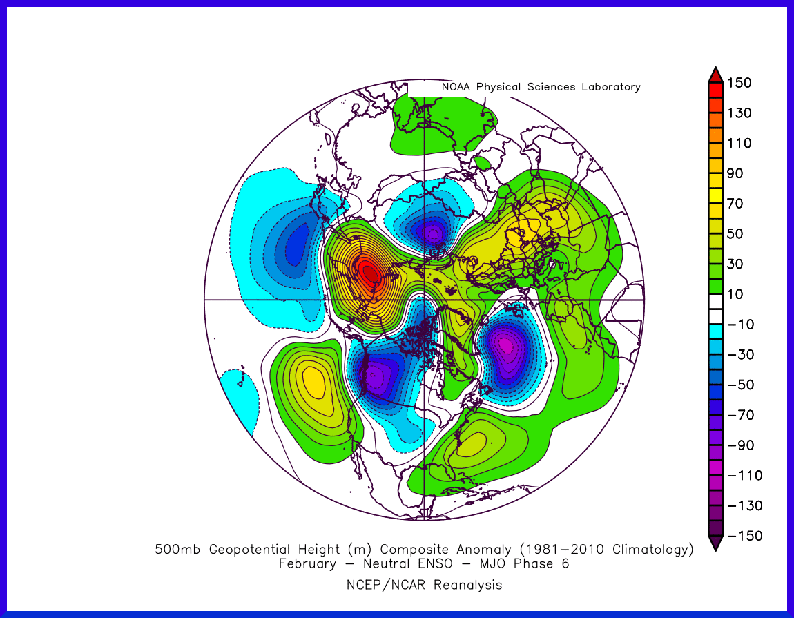
The Euro EPS MJO shows Phase 5 & 6 in Feb and the neutral ENSO composites match up pretty well with modeling. Potential for a storm ejecting out of the SW followed by a cold shot. A lot hinges on the low frequency background state and the models seem to struggle during transition periods.

Image

Image
0 likes   
Winter time post are almost exclusively focused on the DFW area.

User avatar
bubba hotep
S2K Supporter
S2K Supporter
Posts: 5837
Joined: Wed Dec 28, 2016 1:00 am
Location: Collin County Texas

Re: Texas Winter 2016-2017

#4136 Postby bubba hotep » Thu Jan 26, 2017 2:54 pm

South Texas Storms wrote:12z Euro shows a very cold air mass building in western Canada at the end of the run.


There has been a pretty strong signal in the longer range ensembles for big cold building in WCAN in early Feb and this signal has been supported by changes across the Pacific. The big question yet to be answered, where does that cold air go?
0 likes   
Winter time post are almost exclusively focused on the DFW area.

orangeblood
S2K Supporter
S2K Supporter
Posts: 3714
Joined: Tue Dec 15, 2009 6:14 pm
Location: Fort Worth, TX

Re: Texas Winter 2016-2017

#4137 Postby orangeblood » Thu Jan 26, 2017 3:37 pm

bubba hotep wrote:The Euro EPS MJO shows Phase 5 & 6 in Feb and the neutral ENSO composites match up pretty well with modeling. Potential for a storm ejecting out of the SW followed by a cold shot. A lot hinges on the low frequency background state and the models seem to struggle during transition periods.


GFS Ensembles vastly different, swinging MJO back into Phase 8. Canadian more in line with Euro, highest 500mb negative anomalies in Western Canada
0 likes   

User avatar
wxman57
Moderator-Pro Met
Moderator-Pro Met
Posts: 22979
Age: 67
Joined: Sat Jun 21, 2003 8:06 pm
Location: Houston, TX (southwest)

Re: Texas Winter 2016-2017

#4138 Postby wxman57 » Thu Jan 26, 2017 4:38 pm

South Texas Storms wrote:12z Euro shows a very cold air mass building in western Canada at the end of the run.


Perhaps, but the 11-15 day Euro ensembles (850mb temperature anomaly) show marked warming across Texas spreading north and west to cover all areas west of the Mississippi by day 15. The cold air trajectory is mostly eastward - north of the Great Lakes in days 11-15. Only briefly do the EC ensembles have east Texas temps a little below normal around Feb 6-7. Though a 500mb ridge pops up over Alaska and western Canada in 5-8 days, it begins to weaken after day 10 then is replaced by low pressure, as we have now. Basically, the ensembles indicate only a brief period of cold.

GFS ensembles have even less cold for Texas the 6th-7th. Same pattern as the EC ensembles. The cold air is shunted east across southern Canada and the northern U.S. after next week.

Image
0 likes   

User avatar
South Texas Storms
Professional-Met
Professional-Met
Posts: 4227
Joined: Thu Jun 24, 2010 12:28 am
Location: Houston, TX

Re: Texas Winter 2016-2017

#4139 Postby South Texas Storms » Thu Jan 26, 2017 4:59 pm

:uarrow:

Good thing we can't trust the long range models. :wink:

Enjoy our low temperatures near 40F and afternoon highs struggling to reach 60F over the next few days. Multiple heated blankets will be needed! :lol:

By the way, I predict lots of cold mongering will be going on in the office tomorrow. :)
1 likes   

User avatar
Texas Snowman
Storm2k Moderator
Storm2k Moderator
Posts: 6179
Joined: Fri Jan 25, 2008 11:29 am
Location: Denison, Texas

Re: Texas Winter 2016-2017

#4140 Postby Texas Snowman » Thu Jan 26, 2017 5:23 pm

:uarrow: Well, at least he's (Wxman57) consistent in what he trusts and distrusts with long range modeling. I think the pattern is downplaying any and all long range cold and overplaying any long range warmth. :lol:
1 likes   
The above post and any post by Texas Snowman is NOT an official forecast and should not be used as such. It is just the opinion of the poster and may or may not be backed by sound meteorological data. It is NOT endorsed by any professional institution including storm2k.org. For official information, please refer to NWS products.


Return to “Winter Weather”

Who is online

Users browsing this forum: No registered users and 9 guests