Texas Winter 2016-2017

Winter Weather Discussion

Moderator: S2k Moderators

Forum rules

The posts in this forum are NOT official forecast and should not be used as such. They are just the opinion of the poster and may or may not be backed by sound meteorological data. They are NOT endorsed by any professional institution or STORM2K.

Help Support Storm2K
Message
Author
User avatar
Ntxw
Storm2k Moderator
Storm2k Moderator
Posts: 22785
Joined: Wed Oct 21, 2009 6:34 pm
Location: DFW, Texas

Re: Texas Winter 2016-2017

#4621 Postby Ntxw » Wed Feb 15, 2017 9:59 am

Golf7070 wrote:Ntxw, is this just a temporary thing or is this a start of a colder regime due to weakening pattern in pacific from tropical forcing and other things?


It's the progression of the MJO once it's past P8 which is the lower angular momentum. P1-P3 tend to be the EPO block regions, but given wavelengths are shorter as we head towards spring it's hard to lock in any pattern for a long duration. Still may see some cold yet if it verifies.

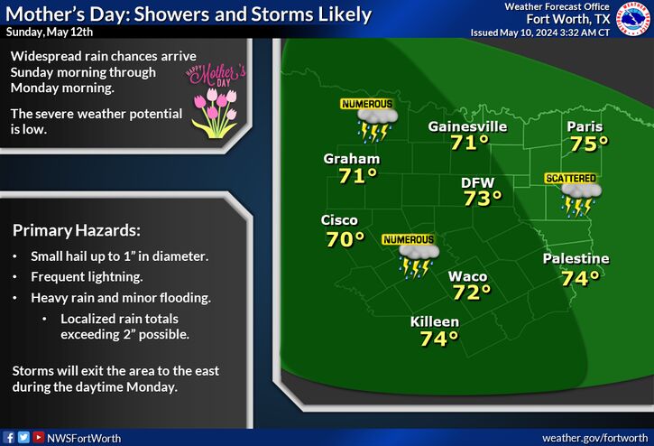
Bigger story right now is the surplus of rainfall we have seen this year, along with severe weather potentials.
1 likes   
The above post and any post by Ntxw is NOT an official forecast and should not be used as such. It is just the opinion of the poster and may or may not be backed by sound meteorological data. It is NOT endorsed by any professional institution including Storm2k. For official information, please refer to NWS products.

  Help support Storm2K!
Help Support Storm2K

User avatar
Portastorm
Storm2k Moderator
Storm2k Moderator
Posts: 9914
Age: 63
Joined: Fri Jul 11, 2003 9:16 am
Location: Round Rock, TX
Contact:

Re: Texas Winter 2016-2017

#4622 Postby Portastorm » Wed Feb 15, 2017 10:17 am

:uarrow:

The larger anomalies for rainfall have occurred west of I-35 based on the 30-day data maps I just looked at on the CPC site. There are some small areas east of I-35 which have seen slightly more than normal precip but not anything significant. Perhaps this next system coming late this weekend will push those "above normal" percentages into a higher realm.
1 likes   
Any forecasts under my name are to be taken with a grain of salt. Get your best forecasts from the National Weather Service and National Hurricane Center.

User avatar
Ntxw
Storm2k Moderator
Storm2k Moderator
Posts: 22785
Joined: Wed Oct 21, 2009 6:34 pm
Location: DFW, Texas

Re: Texas Winter 2016-2017

#4623 Postby Ntxw » Wed Feb 15, 2017 10:34 am

Portastorm wrote::uarrow:

The larger anomalies for rainfall have occurred west of I-35 based on the 30-day data maps I just looked at on the CPC site. There are some small areas east of I-35 which have seen slightly more than normal precip but not anything significant. Perhaps this next system coming late this weekend will push those "above normal" percentages into a higher realm.


Both Mabry and Bergstrom are running 50% greater than normal total winter rainfall. Bergstrom is almost double, for winter being considered dry season that is significant. Percentages are comparable when looking at year to date as well.

DFW is sitting nearly 6 inches in 2017, as this time last year it was a little over an inch. Fast start
0 likes   
The above post and any post by Ntxw is NOT an official forecast and should not be used as such. It is just the opinion of the poster and may or may not be backed by sound meteorological data. It is NOT endorsed by any professional institution including Storm2k. For official information, please refer to NWS products.


  Help support Storm2K!

Help Support Storm2K


User avatar
bubba hotep
S2K Supporter
S2K Supporter
Posts: 5837
Joined: Wed Dec 28, 2016 1:00 am
Location: Collin County Texas

Re: Texas Winter 2016-2017

#4624 Postby bubba hotep » Wed Feb 15, 2017 10:51 am

Ntxw wrote:
Portastorm wrote::uarrow:

The larger anomalies for rainfall have occurred west of I-35 based on the 30-day data maps I just looked at on the CPC site. There are some small areas east of I-35 which have seen slightly more than normal precip but not anything significant. Perhaps this next system coming late this weekend will push those "above normal" percentages into a higher realm.


Both Mabry and Bergstrom are running 50% greater than normal total winter rainfall. Bergstrom is almost double, for winter being considered dry season that is significant. Percentages are comparable when looking at year to date as well.

DFW is sitting nearly 6 inches in 2017, as this time last year it was a little over an inch. Fast start


Looks like DFW is off to a Top 10 start and the 06z GFS has another 3" from this next system.
1 likes   
Winter time post are almost exclusively focused on the DFW area.

User avatar
CaptinCrunch
S2K Supporter
S2K Supporter
Posts: 8728
Age: 57
Joined: Mon Nov 03, 2003 4:33 pm
Location: Kennedale, TX (Tarrant Co.)

Re: Texas Winter 2016-2017

#4625 Postby CaptinCrunch » Wed Feb 15, 2017 11:43 am

Image
Another strong upper level low over northern Mexico will approach the area late this coming weekend, then provide increasing rain and thunderstorm chances by Sunday night and continuing through Monday and possibly Tuesday for all of North and Central Texas. It's still too soon to diagnose the exact storm track, along with the potential for severe storms or flooding. Stay tuned to forecast updates as we get closer to the weekend.


February 2017, 1st. thru 14th.

[TEMPERATURE DATA] --------- [PRECIPITATION DATA]

AVERAGE MONTHLY: 59.3 ----- TOTAL FOR MONTH: 1.51
DPTR FM NORMAL: +11.0 ------- DPTR FM NORMAL: +0.25
1 likes   

User avatar
gboudx
S2K Supporter
S2K Supporter
Posts: 4080
Joined: Thu Sep 04, 2003 1:39 pm
Location: Rockwall, Tx but from Harvey, La

Re: Texas Winter 2016-2017

#4626 Postby gboudx » Wed Feb 15, 2017 12:00 pm

Here's jeff's take no the next system:

It is early…but signs are ominous for early next week.

Powerful upper level storm system moving into the west coast this weekend will arrive into TX late this weekend/early next week. This will potentially bring a high impact weather event to TX.

Moisture return off a very warm Gulf of Mexico (a result of this very mild winter) will begin in earnest Saturday into Sunday. Models are showing “off the charts” moisture levels in place by late Sunday with very impressive PW values of 1.8-2.0 inches or some 275% of normal over SE TX and nearly 400% of normal over N TX. To give an idea of how rare this would be…such moisture values are more common in the June-October time period…and if this actually materializes would potentially be record values for this time of year. The upper level system digs deep into MX and then progresses across TX bringing strong jet stream dynamics across this moisture plume. Lift and instability looks good and there could be the potential for sustained convective training with near summertime rainfall rates. WPC day 6/7 QPF is on the extreme side for such a long term forecast and hits a corridor from Galveston Island southward with 7-9 inches and widespread 5-7 inches over much of SE TX.

This system would also likely have a severe weather threat.

It is way too early to have much confidence in the rainfall totals or placement as well as the severe threat, but this system deserves close attention over the next several days.
0 likes   

User avatar
dhweather
S2K Supporter
S2K Supporter
Posts: 6199
Joined: Sat Aug 14, 2004 9:29 pm
Location: Heath, TX
Contact:

Re: Texas Winter 2016-2017

#4627 Postby dhweather » Wed Feb 15, 2017 12:57 pm

Ntxw wrote:
Portastorm wrote::uarrow:

The larger anomalies for rainfall have occurred west of I-35 based on the 30-day data maps I just looked at on the CPC site. There are some small areas east of I-35 which have seen slightly more than normal precip but not anything significant. Perhaps this next system coming late this weekend will push those "above normal" percentages into a higher realm.


Both Mabry and Bergstrom are running 50% greater than normal total winter rainfall. Bergstrom is almost double, for winter being considered dry season that is significant. Percentages are comparable when looking at year to date as well.

DFW is sitting nearly 6 inches in 2017, as this time last year it was a little over an inch. Fast start


And roughly 30 miles ESE, we have 3.71 for the year. Not complaining, just noting what a difference 30 miles can make.
0 likes   
The above post and any post by dhweather is NOT an official forecast and should not be used as such. It is just the opinion of the poster and may or may not be backed by sound meteorological data. It is NOT endorsed by any professional institution including storm2k.org. For official information, please refer to NWS products.

User avatar
srainhoutx
S2K Supporter
S2K Supporter
Posts: 6919
Age: 67
Joined: Sun Jan 14, 2007 11:34 am
Location: Haywood County, NC
Contact:

Re: Texas Winter 2016-2017

#4628 Postby srainhoutx » Wed Feb 15, 2017 4:35 pm

While it is too soon to know with any certainty exactly what our sensible weather will bring early next week, the afternoon GFS solution suggests 300% above normal moisture values while the ECMWF suggests 400% above normal values across portions of Central, SE and East Texas. The flood threat is slowly increasing.
2 likes   
Carla/Alicia/Jerry(In The Eye)/Michelle/Charley/Ivan/Dennis/Katrina/Rita/Wilma/Ike/Harvey

Member: National Weather Association
Wx Infinity Forums
http://wxinfinity.com/index.php

Facebook.com/WeatherInfinity
Twitter @WeatherInfinity

User avatar
Portastorm
Storm2k Moderator
Storm2k Moderator
Posts: 9914
Age: 63
Joined: Fri Jul 11, 2003 9:16 am
Location: Round Rock, TX
Contact:

Re: Texas Winter 2016-2017

#4629 Postby Portastorm » Wed Feb 15, 2017 4:57 pm

srainhoutx wrote:While it is too soon to know with any certainty exactly what our sensible weather will bring early next week, the afternoon GFS solution suggests 300% above normal moisture values while the ECMWF suggests 400% above normal values across portions of Central, SE and East Texas. The flood threat is slowly increasing.


I'll tell you what ... if the upper level low maintains its structural integrity and comes through Texas that low in latitude ... look out! We've had some very ugly weather in years past in similar setups with moisture values being off the charts like that. We all should keep a very close eye on things for late in the weekend into next week.
1 likes   
Any forecasts under my name are to be taken with a grain of salt. Get your best forecasts from the National Weather Service and National Hurricane Center.

User avatar
1900hurricane
Category 5
Category 5
Posts: 6059
Age: 34
Joined: Fri Feb 06, 2015 12:04 pm
Location: Houston, TX
Contact:

Re: Texas Winter 2016-2017

#4630 Postby 1900hurricane » Wed Feb 15, 2017 4:58 pm

The system as it is modeled now reminds me somewhat of the early March system in Louisiana from last year.
2 likes   
Contract Meteorologist. TAMU & MSST. Fiercely authentic, one of a kind. We are all given free will, so choose a life meant to be lived. We are the Masters of our own Stories.
Opinions expressed are mine alone.

Follow me on Twitter at @1900hurricane : Read blogs at https://1900hurricane.wordpress.com/

User avatar
PTrackerLA
Category 5
Category 5
Posts: 5277
Age: 41
Joined: Thu Oct 10, 2002 8:40 pm
Location: Lafayette, LA

Re: Texas Winter 2016-2017

#4631 Postby PTrackerLA » Wed Feb 15, 2017 6:00 pm

1900hurricane wrote:The system as it is modeled now reminds me somewhat of the early March system in Louisiana from last year.


Starting to notice that too. Looks like someone from SE TX to South LA is going to get a heck of a lot of rain. Luckily we can handle several inches of rain as we are running a nearly 5" deficit just since January 1st.
0 likes   

User avatar
TheProfessor
Professional-Met
Professional-Met
Posts: 3506
Age: 28
Joined: Tue Dec 03, 2013 10:56 am
Location: Wichita, Kansas

Re: Texas Winter 2016-2017

#4632 Postby TheProfessor » Wed Feb 15, 2017 6:10 pm

Went to go eat dinner and I saw some snow falling, wasn't expecting any precip today. It's going to be 60 degrees on Saturday. This winter reminds me of 2011-2012. I'm glad I wasn't back home this winter, My allergies would have been terrible. I got Pneumonia in early 2012 because of that. I definitely hope I don't get pneumonia this year, I can't imagine having pneumonia while taking boundary layer climatology. I've been getting a lot of ear infections this winter though, same thing happened in 2011-2012. I'm ready for spring, I'll be running this weekend if I'm feeling well, I'd like for it to just stay warm.
0 likes   
An alumnus of The Ohio State University.

Your local National Weather Service office is your best source for weather information.

User avatar
wxman57
Moderator-Pro Met
Moderator-Pro Met
Posts: 22978
Age: 67
Joined: Sat Jun 21, 2003 8:06 pm
Location: Houston, TX (southwest)

Re: Texas Winter 2016-2017

#4633 Postby wxman57 » Wed Feb 15, 2017 7:46 pm

I see that somebody left the Canadian door open while I was in Louisiana. Time to warm things back up!

Interesting storm system for next Monday. Don't need any more tornadoes down here.
1 likes   

User avatar
Ntxw
Storm2k Moderator
Storm2k Moderator
Posts: 22785
Joined: Wed Oct 21, 2009 6:34 pm
Location: DFW, Texas

Re: Texas Winter 2016-2017

#4634 Postby Ntxw » Wed Feb 15, 2017 8:17 pm

It ain't over until the fat lady sings and she hasn't sung yet

ImageImage
Image

 https://twitter.com/MJVentrice/status/831981320691732482


0 likes   
The above post and any post by Ntxw is NOT an official forecast and should not be used as such. It is just the opinion of the poster and may or may not be backed by sound meteorological data. It is NOT endorsed by any professional institution including Storm2k. For official information, please refer to NWS products.


  Help support Storm2K!

Help Support Storm2K


User avatar
bubba hotep
S2K Supporter
S2K Supporter
Posts: 5837
Joined: Wed Dec 28, 2016 1:00 am
Location: Collin County Texas

Re: Texas Winter 2016-2017

#4635 Postby bubba hotep » Wed Feb 15, 2017 10:19 pm

1900hurricane wrote:The system as it is modeled now reminds me somewhat of the early March system in Louisiana from last year.


You aren't the only one

 https://twitter.com/whatisthisrds/status/832066415972728833


1 likes   
Winter time post are almost exclusively focused on the DFW area.

User avatar
bubba hotep
S2K Supporter
S2K Supporter
Posts: 5837
Joined: Wed Dec 28, 2016 1:00 am
Location: Collin County Texas

Re: Texas Winter 2016-2017

#4636 Postby bubba hotep » Wed Feb 15, 2017 10:22 pm

wxman57 wrote:I see that somebody left the Canadian door open while I was in Louisiana. Time to warm things back up!

Interesting storm system for next Monday. Don't need any more tornadoes down here.


The WSI index has shown some promise in the longer range but SPC is still going with "predictability too low" which seems like a good strategy.

Image
1 likes   
Winter time post are almost exclusively focused on the DFW area.

User avatar
TeamPlayersBlue
Category 5
Category 5
Posts: 3445
Joined: Tue Feb 02, 2010 1:44 am
Location: Denver/Applewood, CO

Re: Texas Winter 2016-2017

#4637 Postby TeamPlayersBlue » Wed Feb 15, 2017 10:25 pm

Might be a bit early but the SAI index, can we chalk this one up as a loss? We had a period where cold anomalies built up in Canada a few times, led to two different freeze events for us here in SE Tx, but again, the SAI didnt really impress me. I initially thought it led to more blocking or a -NAO later on in the winter, but it seems the greatest impact this year was early on in the season. Obviously SOOO many factors at play in the weather. Any input on this?

I feel the pacific threw us for a loop this winter. Highly unpredictable.
0 likes   
Personal Forecast Disclaimer:
The posts in this forum are NOT official forecast and should not be used as such. They are just the opinion of the poster and may or may not be backed by sound meteorological data. They are NOT endorsed by any professional institution or storm2k.org. For official information, please refer to the NHC and NWS products.

User avatar
Ntxw
Storm2k Moderator
Storm2k Moderator
Posts: 22785
Joined: Wed Oct 21, 2009 6:34 pm
Location: DFW, Texas

Re: Texas Winter 2016-2017

#4638 Postby Ntxw » Wed Feb 15, 2017 10:30 pm

TeamPlayersBlue wrote:Might be a bit early but the SAI index, can we chalk this one up as a loss? We had a period where cold anomalies built up in Canada a few times, led to two different freeze events for us here in SE Tx, but again, the SAI didnt really impress me. I initially thought it led to more blocking or a -NAO later on in the winter, but it seems the greatest impact this year was early on in the season. Obviously SOOO many factors at play in the weather. Any input on this?

I feel the pacific threw us for a loop this winter. Highly unpredictable.


SAI's correlation with the AO has been really bad. We were better off going by solar activity.Also can't dismiss the fact that Super El Nino's have lingering effects in the oceans and atmosphere for years no matter how subtle.
0 likes   
The above post and any post by Ntxw is NOT an official forecast and should not be used as such. It is just the opinion of the poster and may or may not be backed by sound meteorological data. It is NOT endorsed by any professional institution including Storm2k. For official information, please refer to NWS products.


  Help support Storm2K!

Help Support Storm2K


Brent
S2K Supporter
S2K Supporter
Posts: 38089
Age: 36
Joined: Sun May 16, 2004 10:30 pm
Location: Tulsa Oklahoma
Contact:

Re: Texas Winter 2016-2017

#4639 Postby Brent » Wed Feb 15, 2017 10:39 pm

I really can't believe El nino may be coming right back... I still feel a lot of this messed up pattern is leftovers from the last one... :double:
0 likes   
#neversummer

User avatar
bubba hotep
S2K Supporter
S2K Supporter
Posts: 5837
Joined: Wed Dec 28, 2016 1:00 am
Location: Collin County Texas

Re: Texas Winter 2016-2017

#4640 Postby bubba hotep » Wed Feb 15, 2017 10:43 pm

Brent wrote:I really can't believe El nino may be coming right back... I still feel a lot of this messed up pattern is leftovers from the last one... :double:


That is a pretty good guess. The super nino data set is too small but they appear to really mix things up long term. One possible saving grace, if the QBO does flip then that should help keep this coming nino in check.
0 likes   
Winter time post are almost exclusively focused on the DFW area.


Return to “Winter Weather”

Who is online

Users browsing this forum: wxman22 and 8 guests