Texas Winter 2016-2017
Moderator: S2k Moderators
Forum rules
 The posts in this forum are NOT official forecast and should not be used as such. They are just the opinion of the poster and may or may not be backed by sound meteorological data. They are NOT endorsed by any professional institution or STORM2K.

The posts in this forum are NOT official forecast and should not be used as such. They are just the opinion of the poster and may or may not be backed by sound meteorological data. They are NOT endorsed by any professional institution or STORM2K.


Re: Texas Winter 2016-2017
Any cells or clusters running south to norrh isolated is what we should watch for. Most of DFW's impactful tornados recently have come from storms moving in that direction including post Christmas EF4
1 likes
The above post and any post by Ntxw is NOT an official forecast and should not be used as such. It is just the opinion of the poster and may or may not be backed by sound meteorological data. It is NOT endorsed by any professional institution including Storm2k. For official information, please refer to NWS products.
Help support Storm2K!
Re: Texas Winter 2016-2017
Golf7070 wrote:Ntxw, do you have an idea why this winter is so warm, especially with mjo on move through the phase chart? What phase is good for us? I'm now confused and clueless
I think there has been a number of reasons. For one the cold pool south of Alaska is essentially the same strong cold SST configuration as last winter. During bouts we had La Nina try to shake up the NPAC with its favored ridging but when it retrograded, we reverted back to the strong pac/jet cold sst pattern prevalent last year inbetween. There has just been a lot of warmth at the lower levels in North America both in intensity and coverage.
I still think it will get cold from the -PNA, is that enough for snow is anyone's guess. Its getting tougher though.
0 likes
The above post and any post by Ntxw is NOT an official forecast and should not be used as such. It is just the opinion of the poster and may or may not be backed by sound meteorological data. It is NOT endorsed by any professional institution including Storm2k. For official information, please refer to NWS products.
Help support Storm2K!
Help support Storm2K!
-
TeamPlayersBlue

- Category 5

- Posts: 3531
- Joined: Tue Feb 02, 2010 1:44 am
- Location: Denver/Applewood, CO
Re: Texas Winter 2016-2017
Ntxw wrote:Golf7070 wrote:Ntxw, do you have an idea why this winter is so warm, especially with mjo on move through the phase chart? What phase is good for us? I'm now confused and clueless
I think there has been a number of reasons. For one the cold pool south of Alaska is essentially the same strong cold SST configuration as last winter. During bouts we had La Nina try to shake up the NPAC with its favored ridging but when it retrograded, we reverted back to the strong pac/jet cold sst pattern prevalent last year inbetween. There has just been a lot of warmth at the lower levels in North America both in intensity and coverage.
I still think it will get cold from the -PNA, is that enough for snow is anyone's guess. Its getting tougher though.
In november, the winds coming off of Siberia from the Aleutian low dropped the SST a TON. It never really recovered from that.
0 likes
Personal Forecast Disclaimer:
The posts in this forum are NOT official forecast and should not be used as such. They are just the opinion of the poster and may or may not be backed by sound meteorological data. They are NOT endorsed by any professional institution or storm2k.org. For official information, please refer to the NHC and NWS products.
The posts in this forum are NOT official forecast and should not be used as such. They are just the opinion of the poster and may or may not be backed by sound meteorological data. They are NOT endorsed by any professional institution or storm2k.org. For official information, please refer to the NHC and NWS products.
-
bubba hotep

- S2K Supporter

- Posts: 6014
- Joined: Wed Dec 28, 2016 1:00 am
- Location: Collin County Texas
Re: Texas Winter 2016-2017
Pretty big cap in place across DFW based on the 12z sounding but short range CAMs and SPC see a threat farther to the west this afternoon:
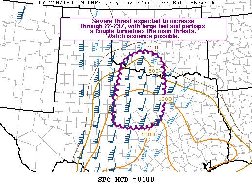
Mesoscale Discussion 0188
NWS Storm Prediction Center Norman OK
0200 PM CST Sun Feb 19 2017
Areas affected...Parts of north TX and southern OK
Concerning...Severe potential...Watch possible
Valid 192000Z - 192230Z
Probability of Watch Issuance...60 percent
SUMMARY...The severe threat is expected to continue increasing
through 22-23Z (4-5 PM CST), with large hail and perhaps a couple of
tornadoes the main threats expected. Watch issuance is possible.
DISCUSSION...Low-level convergence is weak along an ill-defined
dryline/cold front feature extending north-south across much of west
TX early this afternoon. Regardless, as a southern-stream shortwave
trough/low approaches the southern Plains from the west this
afternoon and evening, large-scale forcing for ascent should
gradually increase across north TX and southern OK. Although
widespread cloudiness has hampered diurnal heating somewhat south of
a warm front located across north TX/southern OK, continued
low-level warm air advection and earlier clearing this morning has
allowed surface temperatures to generally warm into the upper 60s to
low 70s across this area. Adequate low-level moisture to the south
of the warm front, with surface dewpoints in the low to mid 60s,
will support convective development/maintenance.
A modestly steepened mid-level lapse rate plume will persist over
the discussion area through this evening, and combined with
sufficient low-level moisture, a corridor of weak to moderate
instability (500-1500 J/kg MLCAPE) is present across much of
central/north TX into southern OK, decreasing with northward extent.
Largely unidirectional southerly flow strengthening with height is
occurring across the same general area in association with the
approaching mid-level trough/low. Effective bulk shear values of
40-60 kt will easily support supercell structures. Some backing of
the low-level wind field to southeasterly will be possible across
parts of north TX into southern OK per latest RAP guidance, as a
southerly/southeasterly low-level jet is forecast to strengthen
across the eastern fringes of the discussion area by early evening
(around 00Z).
Initial convective development will likely occur by 22-23Z as
convective inhibition erodes with continued modest daytime heating
and low-level moistening. This activity should be mainly discrete
supercells posing a large hail threat, with some initial storm
splits likely given the largely unidirectional flow. If storm mode
can remain mostly discrete into the early evening hours while
remaining surface based, then the possibility for a couple tornadoes
would increase as the low-level jet strengthens and effective SRH
likewise increases. Eventual upscale growth into a QLCS with some
wind threat appears probable by mid to late evening.
..Gleason/Guyer.. 02/19/2017
0 likes
Winter time post are almost exclusively focused on the DFW area.

Re: Texas Winter 2016-2017
Sun is out now in my area and the temp has reached 80 degrees. If the cap is holding in the DFW area then it must be holding over Austin too. It's almost 3p.m. so will be closely watching the visible satellite and radars.
0 likes
Resident Rain Miser
I am a weather hobbyist living 3.5 miles south of Downtown Austin and in no way or fashion should anything I say concerning forecasts be taken seriously. Please check your local NWS for accurate weather forecasting and conditions.
I am a weather hobbyist living 3.5 miles south of Downtown Austin and in no way or fashion should anything I say concerning forecasts be taken seriously. Please check your local NWS for accurate weather forecasting and conditions.
-
bubba hotep
- S2K Supporter
- Posts: 6014
- Joined: Wed Dec 28, 2016 1:00 am
- Location: Collin County Texas
Re: Texas Winter 2016-2017
Looking at surface obs, it looks like there is a warm front draped along I30 from NE Texas down into the DFW area. That might be a focus area to watch for a quick spin up later, if any isolated storms can fire and move north towards that boundary.
ETA: Latest run of HRRR just pushes a semi broken line of storms through DFW, not too interesting looking
ETA: Latest run of HRRR just pushes a semi broken line of storms through DFW, not too interesting looking
0 likes
Winter time post are almost exclusively focused on the DFW area.
-
bubba hotep
- S2K Supporter
- Posts: 6014
- Joined: Wed Dec 28, 2016 1:00 am
- Location: Collin County Texas
Re: Texas Winter 2016-2017
This is basically the only winter we have left, long range GFS fantasy images that will never come to pass lol

0 likes
Winter time post are almost exclusively focused on the DFW area.
-
Brent
- S2K Supporter
- Posts: 38759
- Age: 37
- Joined: Sun May 16, 2004 10:30 pm
- Location: Tulsa Oklahoma
- Contact:
Re: Texas Winter 2016-2017
bubba hotep wrote:This is basically the only winter we have left, long range GFS fantasy images that will never come to pass lol
Lol and the cold on the gfs isn't getting closer either...
0 likes
#neversummer
Re: Texas Winter 2016-2017
As a reminder we will move to the spring thread for MAM (March-April-May) to be consistent with the changeovers we have done for a good year+ now. Also with tradition if there is wintry threats in March I will keep this thread open for discussion. You better believe it, days of Texas heat and high AC bills just around the corner. Enjoy what you have now.
FYI no one has made a spring thread yet, usually someone has by now
FYI no one has made a spring thread yet, usually someone has by now
0 likes
The above post and any post by Ntxw is NOT an official forecast and should not be used as such. It is just the opinion of the poster and may or may not be backed by sound meteorological data. It is NOT endorsed by any professional institution including Storm2k. For official information, please refer to NWS products.
Help support Storm2K!
Help support Storm2K!
-
gboudx

- S2K Supporter
- Posts: 4090
- Joined: Thu Sep 04, 2003 1:39 pm
- Location: Rockwall, Tx but from Harvey, La
Re: Texas Winter 2016-2017
Ntxw wrote:
FYI no one has made a spring thread yet, usually someone has by now
TheAustinMan started one.
viewtopic.php?f=24&t=118608
0 likes
Re: Texas Winter 2016-2017
gboudx wrote:Ntxw wrote:
FYI no one has made a spring thread yet, usually someone has by now
TheAustinMan started one.
viewtopic.php?f=24&t=118608
I completely missed that
Thanks!
0 likes
The above post and any post by Ntxw is NOT an official forecast and should not be used as such. It is just the opinion of the poster and may or may not be backed by sound meteorological data. It is NOT endorsed by any professional institution including Storm2k. For official information, please refer to NWS products.
Help support Storm2K!
Help support Storm2K!
-
Brent
- S2K Supporter
- Posts: 38759
- Age: 37
- Joined: Sun May 16, 2004 10:30 pm
- Location: Tulsa Oklahoma
- Contact:
Re: Texas Winter 2016-2017
Ntxw wrote:As a reminder we will move to the spring thread for MAM (March-April-May) to be consistent with the changeovers we have done for a good year+ now. Also with tradition if there is wintry threats in March I will keep this thread open for discussion. You better believe it, days of Texas heat and high AC bills just around the corner. Enjoy what you have now.
FYI no one has made a spring thread yet, usually someone has by now
So true... sadly despite the conditions in the pacific it is guaranteed to be way too hot for way too long all too soon...
0 likes
#neversummer
-
South Texas Storms

- Professional-Met

- Posts: 4261
- Joined: Thu Jun 24, 2010 12:28 am
- Location: Houston, TX
Re: Texas Winter 2016-2017
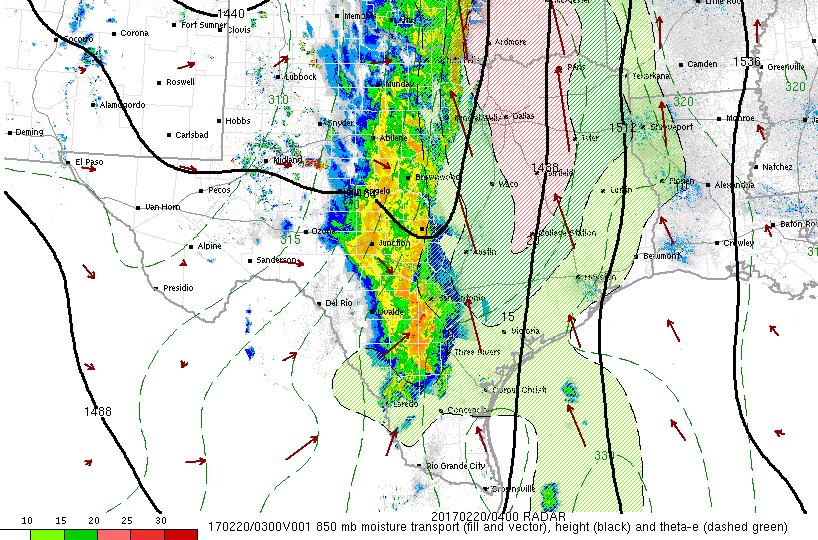
The latest radar is such a beautiful sight! Line of heavy thunderstorms from Wichita Falls to Laredo 
1 likes
-
bubba hotep
- S2K Supporter
- Posts: 6014
- Joined: Wed Dec 28, 2016 1:00 am
- Location: Collin County Texas
Re: Texas Winter 2016-2017
South Texas Storms wrote:The latest radar is such a beautiful sight! Line of heavy thunderstorms from Wichita Falls to Laredo
Very 2015 like!
1 likes
Winter time post are almost exclusively focused on the DFW area.

Re: Texas Winter 2016-2017
The models apparently were too aggressive with moisture return. FWD sounding this evening has PWAT at 1.32" , nothing close to the 3" + they were seeing Wednesday/Thursday.
Of course, I don't think they had CAPE at 2K either.
Of course, I don't think they had CAPE at 2K either.
0 likes
The above post and any post by dhweather is NOT an official forecast and should not be used as such. It is just the opinion of the poster and may or may not be backed by sound meteorological data. It is NOT endorsed by any professional institution including storm2k.org. For official information, please refer to NWS products.
-
weatherdude1108
- Category 5
- Posts: 4228
- Joined: Tue Dec 13, 2011 1:04 pm
- Location: Northwest Austin/Cedar Park, TX
Re: Texas Winter 2016-2017
It looks like the storms are going linear and transitioning into a mostly heavy rain threat. Bring on the rain! 
1 likes
The preceding post is NOT an official forecast, and should not be used as such. It is only the opinion of the poster and may or may not be backed by sound meteorological data. It is NOT endorsed by any professional institution including storm2k.org. For Official Information please refer to the NHC and NWS products.
-
TeamPlayersBlue
- Category 5
- Posts: 3531
- Joined: Tue Feb 02, 2010 1:44 am
- Location: Denver/Applewood, CO
Re: Texas Winter 2016-2017
I think the storms will get here quicker than anticipated too. The last two similar systems that came through arrived much quicker than thought. Maybe the models dont do so well with low pressures crossing the state.
Edit: I see the HRRR is already much quicker. Was saying 11 am earlier today, now looks like 7 am the line hits West Houston, just in time for rush hour. Its a bank holiday so maybe many people have the day off.
Edit: I see the HRRR is already much quicker. Was saying 11 am earlier today, now looks like 7 am the line hits West Houston, just in time for rush hour. Its a bank holiday so maybe many people have the day off.
0 likes
Personal Forecast Disclaimer:
The posts in this forum are NOT official forecast and should not be used as such. They are just the opinion of the poster and may or may not be backed by sound meteorological data. They are NOT endorsed by any professional institution or storm2k.org. For official information, please refer to the NHC and NWS products.
The posts in this forum are NOT official forecast and should not be used as such. They are just the opinion of the poster and may or may not be backed by sound meteorological data. They are NOT endorsed by any professional institution or storm2k.org. For official information, please refer to the NHC and NWS products.
-
wxman57

- Moderator-Pro Met

- Posts: 23175
- Age: 68
- Joined: Sat Jun 21, 2003 8:06 pm
- Location: Houston, TX (southwest)
Re: Texas Winter 2016-2017
Noticed the smell of ligustrum flowering on my ride today. Another sign of spring. Still don't see any leaves on the pecan trees. They're always the last to leaf out. There's really no point in continuing this thread. Winter is over for Texas. Moving to spring thread.
0 likes
Re: Texas Winter 2016-2017
Some 3+ inches have fallen in NW Texas where heavier radar returns have occurred

Most guidance (even now the GFS) fills it in more the further east it goes. I-35 (and then I-45 thereafter) should get a pretty good soaking tonight
Most guidance (even now the GFS) fills it in more the further east it goes. I-35 (and then I-45 thereafter) should get a pretty good soaking tonight
1 likes
The above post and any post by Ntxw is NOT an official forecast and should not be used as such. It is just the opinion of the poster and may or may not be backed by sound meteorological data. It is NOT endorsed by any professional institution including Storm2k. For official information, please refer to NWS products.
Help support Storm2K!
Help support Storm2K!
-
bubba hotep
- S2K Supporter
- Posts: 6014
- Joined: Wed Dec 28, 2016 1:00 am
- Location: Collin County Texas
Re: Texas Winter 2016-2017
Ntxw wrote:Some 3+ inches have fallen in NW Texas where heavier radar returns have occurred
Most guidance (even now the GFS) fills it in more the further east it goes. I-35 (and then I-45 thereafter) should get a pretty good soaking tonight
Yea, the 00z GFS finally folded and now shows 2"+ for areas east of I35 in DFW. It wouldn't surprise me to see some spots get even more than that with this look:

0 likes
Winter time post are almost exclusively focused on the DFW area.
Who is online
Users browsing this forum: No registered users and 160 guests