

Mid-80s and some may even approach 90 next few days. March is all but guaranteed another above normal month to continue the streak. Heat has been the theme since early 2015. Cool months have come only when it rains a lot.
This has been a long nightmare that won't end for a cold lover. Heat Miser won't quit.
Texas Spring 2017
Moderator: S2k Moderators
Forum rules

The posts in this forum are NOT official forecast and should not be used as such. They are just the opinion of the poster and may or may not be backed by sound meteorological data. They are NOT endorsed by any professional institution or STORM2K.
Re: Texas Spring 2017
0 likes
The above post and any post by Ntxw is NOT an official forecast and should not be used as such. It is just the opinion of the poster and may or may not be backed by sound meteorological data. It is NOT endorsed by any professional institution including Storm2k. For official information, please refer to NWS products.
Help support Storm2K!
-
bubba hotep

- S2K Supporter

- Posts: 6013
- Joined: Wed Dec 28, 2016 1:00 am
- Location: Collin County Texas
Re: Texas Spring 2017
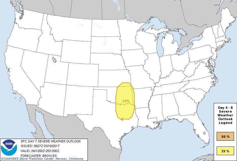
There have been some mentions about the end of next week on here for almost a week now and SPC finally gets into the game:
0 likes
Winter time post are almost exclusively focused on the DFW area.
-
bubba hotep
- S2K Supporter
- Posts: 6013
- Joined: Wed Dec 28, 2016 1:00 am
- Location: Collin County Texas
Re: Texas Spring 2017
Models have the dryline to I35 by 00z next Friday. It seems like the models were too fast to mix the dryline east last year, so wonder if that will be a theme again this year? Pointless to worry about details at this point but all the models show convection moving through the DFW area on Friday afternoon.
0 likes
Winter time post are almost exclusively focused on the DFW area.
Re: Texas Spring 2017
I'm hoping for a good bit of rain late week. DFW has totaled 0.19 inches and normal is 2.05 to date with 1.5 weeks left in March. Past 60 days or so has been abnormally dry. Much of Dallas and Rockwall counties are under moderate drought along with southeastern Collin co
0 likes
The above post and any post by Ntxw is NOT an official forecast and should not be used as such. It is just the opinion of the poster and may or may not be backed by sound meteorological data. It is NOT endorsed by any professional institution including Storm2k. For official information, please refer to NWS products.
Help support Storm2K!
Help support Storm2K!
-
bubba hotep
- S2K Supporter
- Posts: 6013
- Joined: Wed Dec 28, 2016 1:00 am
- Location: Collin County Texas
Re: Texas Spring 2017
Models shifted eastward with the heaviest rain for next weeks systems. Trough timing and orientation keep shifting around and the quality of moisture return is in question. A positive tilted trough that pushes trough during the early part of the day would be a bummer and pretty nina like.
0 likes
Winter time post are almost exclusively focused on the DFW area.

Re: Texas Spring 2017
Yea, I'm not liking how next weekend is evolving. Even if central and north central areas of the state get rain, it won't be much. Sorry to hear about the worsening dry conditions up in DFW. Austin has been lucky so far this year but as with all good things, the streak will end and I'm afraid sooner rather than later.
0 likes
Resident Rain Miser
I am a weather hobbyist living 3.5 miles south of Downtown Austin and in no way or fashion should anything I say concerning forecasts be taken seriously. Please check your local NWS for accurate weather forecasting and conditions.
I am a weather hobbyist living 3.5 miles south of Downtown Austin and in no way or fashion should anything I say concerning forecasts be taken seriously. Please check your local NWS for accurate weather forecasting and conditions.
Re: Texas Spring 2017
JDawg512 wrote:Yea, I'm not liking how next weekend is evolving. Even if central and north central areas of the state get rain, it won't be much. Sorry to hear about the worsening dry conditions up in DFW. Austin has been lucky so far this year but as with all good things, the streak will end and I'm afraid sooner rather than later.
So far it hasn't done much damage. A period of decent rain will improve it pretty quickly, but until I see real changes in the tropical Pacific I'm not buying runs of widespread heavy rains. Quick passage of squall lines perhaps. April does look better as many has chimed in but until the easterly trades shut down within reasonable range it could get pushed back. I am optimistic the SW nearly stationary trough will bring such rains depicted by long range guidance come April.
0 likes
The above post and any post by Ntxw is NOT an official forecast and should not be used as such. It is just the opinion of the poster and may or may not be backed by sound meteorological data. It is NOT endorsed by any professional institution including Storm2k. For official information, please refer to NWS products.
Help support Storm2K!
Help support Storm2K!
-
TheAustinMan

- Category 5

- Posts: 1060
- Joined: Mon Jul 08, 2013 4:26 pm
- Location: Central TX / United States
Re: Texas Spring 2017
Light rainfall across Texas as depicted on the quantitative precipitation totals on the 18z GFS over the next week or so. Hopefully we get a nice batch of healthy rains... not too little and not too much.

Source: Pivotal Weather
Source: Pivotal Weather
0 likes
Treat my opinions with a grain of salt. For official information see your local weather service.
“It's tough to make predictions, especially about the future.”
“It's tough to make predictions, especially about the future.”
-
Brent
- S2K Supporter
- Posts: 38729
- Age: 37
- Joined: Sun May 16, 2004 10:30 pm
- Location: Tulsa Oklahoma
- Contact:
Re: Texas Spring 2017
pattern still looks active to end March and begin April but I'm waiting to see if it's still there in a few days... the 18z GFS has a flood the first day my parents are here. 
So does the 0z Euro but it is 10 days out
So does the 0z Euro but it is 10 days out
0 likes
#neversummer
-
srainhoutx

- S2K Supporter
- Posts: 6919
- Age: 68
- Joined: Sun Jan 14, 2007 11:34 am
- Location: Haywood County, NC
- Contact:
Re: Texas Spring 2017
Will need to monitor mid next week as a deep trough and a potent upper low ejects out of Northern Mexico and the Southern Rockies. The potential exists for a very stormy and wet pattern next Tuesday into early next Thursday if the ECMWF solution is somewhat correct.
1 likes
Carla/Alicia/Jerry(In The Eye)/Michelle/Charley/Ivan/Dennis/Katrina/Rita/Wilma/Ike/Harvey
Member: National Weather Association
Wx Infinity Forums
http://wxinfinity.com/index.php
Facebook.com/WeatherInfinity
Twitter @WeatherInfinity
Member: National Weather Association
Wx Infinity Forums
http://wxinfinity.com/index.php
Facebook.com/WeatherInfinity
Twitter @WeatherInfinity
-
wxman57

- Moderator-Pro Met

- Posts: 23172
- Age: 68
- Joined: Sat Jun 21, 2003 8:06 pm
- Location: Houston, TX (southwest)
Re: Texas Spring 2017
 Winter is finally officially over! Now, if the temps could only get back up to February levels...
No sign of any significant cold fronts through March, possibly a front the first week of April. Perhaps some heavy thunderstorms across NE-SE TX on the 29th, but that's a log way out to be confident. Storms possible this Friday, too, but maybe not so strong.
0 likes
-
aggiecutter
- Category 5
- Posts: 1755
- Joined: Thu Oct 14, 2004 9:22 pm
- Location: Texarkana

-
South Texas Storms

- Professional-Met

- Posts: 4256
- Joined: Thu Jun 24, 2010 12:28 am
- Location: Houston, TX
-
weatherdude1108
- Category 5
- Posts: 4228
- Joined: Tue Dec 13, 2011 1:04 pm
- Location: Northwest Austin/Cedar Park, TX
Re: Texas Spring 2017
Bob Rose:
Changes in the current weather pattern are forecast to take place Friday when the ridge of high pressure over Texas shifts east and a trough of low over the Desert Southwest ejects northeast to the Plains states. The trough will help push a Pacific cold across the region Friday into Friday night. A few rain showers and thunderstorms will be possible across the Hill Country and Central Texas regions late Thursday night into early Friday morning out ahead of the front. A line of rain showers and thunderstorms is forecast to develop along the cold front Friday morning as the front moves across the Hill Country. This line of rain and storms is forecast to push east across Central Texas and the coastal plains region Friday afternoon and Friday evening. The probability for rain Friday is expected to be near 50-60 percent. The chance for rain should taper off from west to east Friday night as drier and slightly cooler air spreads in behind the cold front. Rain amounts Thursday night through Friday night are forecast to generally total around a half of an inch. The northern counties of Central Texas and the Hill Country could see some totals towards 0.75 inches. Storm Prediction Center forecasters are closely monitoring weather developments on Friday. They feel some of the storms may become severe across North and Northeast Texas. But as of today, it appears the severe weather threat will primarily be confined to North Texas, with a much lower severe weather threat across Central Texas and the middle Texas coast. Friday's high temperature will be around 80-82 degrees.
Sunny and just slightly cooler weather is forecast behind the cold front Friday night into Saturday. Lows Saturday morning will include the upper 40s across the Hill Country, the mid 50s across Central Texas and the low 60s towards the coast. High temperatures Saturday will be around 78-80 degrees. Mostly sunny and warmer weather is forecast next Sunday and Monday, with high temperatures back into the low and mid-80s.
An unsettled weather pattern is forecast to take shape next Tuesday through Thursday when a large trough of low pressure slowly tracks east out of the southwestern US. Abundant moisture is forecast to spread north ahead of the trough, and will cause a good chance for rain and thunderstorms Tuesday night through Thursday. While there is still much uncertainty this far out, some of the forecast solutions indicate this period could be quite wet. Details on this period of unsettled weather will become clearer later this week. Temperatures next Tuesday through Thursday will remain warm, with highs in the upper 70s to low 80s.
Month to date, temperatures across Central Texas have been averaging between 4 and 6 degrees above normal.

Recent high temperatures in the middle 80s and lows in the low 60s are actually more typical of mid-May, rather than the middle of March. For the first 19-days of March, the temperature at Austin-Camp Mabry has averaged 65.6 degrees. This is 5.3 degrees above normal and ranks as the 10th warmest March 1-19 on record.
Bob
http://www.lcra.org/water/river-and-wea ... ather.aspx
Changes in the current weather pattern are forecast to take place Friday when the ridge of high pressure over Texas shifts east and a trough of low over the Desert Southwest ejects northeast to the Plains states. The trough will help push a Pacific cold across the region Friday into Friday night. A few rain showers and thunderstorms will be possible across the Hill Country and Central Texas regions late Thursday night into early Friday morning out ahead of the front. A line of rain showers and thunderstorms is forecast to develop along the cold front Friday morning as the front moves across the Hill Country. This line of rain and storms is forecast to push east across Central Texas and the coastal plains region Friday afternoon and Friday evening. The probability for rain Friday is expected to be near 50-60 percent. The chance for rain should taper off from west to east Friday night as drier and slightly cooler air spreads in behind the cold front. Rain amounts Thursday night through Friday night are forecast to generally total around a half of an inch. The northern counties of Central Texas and the Hill Country could see some totals towards 0.75 inches. Storm Prediction Center forecasters are closely monitoring weather developments on Friday. They feel some of the storms may become severe across North and Northeast Texas. But as of today, it appears the severe weather threat will primarily be confined to North Texas, with a much lower severe weather threat across Central Texas and the middle Texas coast. Friday's high temperature will be around 80-82 degrees.
Sunny and just slightly cooler weather is forecast behind the cold front Friday night into Saturday. Lows Saturday morning will include the upper 40s across the Hill Country, the mid 50s across Central Texas and the low 60s towards the coast. High temperatures Saturday will be around 78-80 degrees. Mostly sunny and warmer weather is forecast next Sunday and Monday, with high temperatures back into the low and mid-80s.
An unsettled weather pattern is forecast to take shape next Tuesday through Thursday when a large trough of low pressure slowly tracks east out of the southwestern US. Abundant moisture is forecast to spread north ahead of the trough, and will cause a good chance for rain and thunderstorms Tuesday night through Thursday. While there is still much uncertainty this far out, some of the forecast solutions indicate this period could be quite wet. Details on this period of unsettled weather will become clearer later this week. Temperatures next Tuesday through Thursday will remain warm, with highs in the upper 70s to low 80s.
Month to date, temperatures across Central Texas have been averaging between 4 and 6 degrees above normal.
Recent high temperatures in the middle 80s and lows in the low 60s are actually more typical of mid-May, rather than the middle of March. For the first 19-days of March, the temperature at Austin-Camp Mabry has averaged 65.6 degrees. This is 5.3 degrees above normal and ranks as the 10th warmest March 1-19 on record.
Bob
http://www.lcra.org/water/river-and-wea ... ather.aspx
1 likes
The preceding post is NOT an official forecast, and should not be used as such. It is only the opinion of the poster and may or may not be backed by sound meteorological data. It is NOT endorsed by any professional institution including storm2k.org. For Official Information please refer to the NHC and NWS products.
-
wxman57
- Moderator-Pro Met
- Posts: 23172
- Age: 68
- Joined: Sat Jun 21, 2003 8:06 pm
- Location: Houston, TX (southwest)
Re: Texas Spring 2017
South Texas Storms wrote:91F at DFW. Ties the record for today.
Quit bragging. I've found March to be a bit too cool so far. No sign of any really cool air through the 31st, though. Think of the next two weeks as cool summer days. Severe winter cold and ice is coming next fall...
1 likes
Re: Texas Spring 2017
Not really news that its quite warm as March continues where Feb left off. Its really been extreme even for extremes in terms of the consistency of warmth and overachieving warm days the past 2 years or so. Just keep forecasting above normal for the next month and you will probably be right. Every now and then look at rainfall, if you see it then a cooler month might work otherwise go with the trend.
Feels strange normalizing 5F+ for monthly departures
Feels strange normalizing 5F+ for monthly departures
0 likes
The above post and any post by Ntxw is NOT an official forecast and should not be used as such. It is just the opinion of the poster and may or may not be backed by sound meteorological data. It is NOT endorsed by any professional institution including Storm2k. For official information, please refer to NWS products.
Help support Storm2K!
Help support Storm2K!
-
Brent
- S2K Supporter
- Posts: 38729
- Age: 37
- Joined: Sun May 16, 2004 10:30 pm
- Location: Tulsa Oklahoma
- Contact:
Re: Texas Spring 2017
wxman57 wrote: Severe winter cold and ice is coming next fall...
Yall heard the man lmao
0 likes
#neversummer
-
weathaguyry

- Category 5
- Posts: 1273
- Age: 22
- Joined: Wed Jun 15, 2016 5:16 am
- Location: Long Island, NY
Re: Texas Spring 2017
Oh quit bragging, here in New York we are jumping up and down because it may reach 60 next Saturday...
0 likes
My posts are only my opinions and NOT official forecasts. For official forecasts, consult the National Hurricane Center or the National Weather Service.
Irene 11', Sandy 12', Fay 20’, Isaias 20’, Elsa 21’, Henri 21’, Ida 21’
Irene 11', Sandy 12', Fay 20’, Isaias 20’, Elsa 21’, Henri 21’, Ida 21’
-
TheProfessor

- Professional-Met
- Posts: 3506
- Age: 29
- Joined: Tue Dec 03, 2013 10:56 am
- Location: Wichita, Kansas
Re: Texas Spring 2017
Whew, looks like I left Texas just in time. Was a nice 45 degrees here in Ohio today. A bit chilly to do sprints in but a lot better then 91 in March!
0 likes
An alumnus of The Ohio State University.
Your local National Weather Service office is your best source for weather information.
Your local National Weather Service office is your best source for weather information.
Return to “USA & Caribbean Weather”
Who is online
Users browsing this forum: TomballEd and 126 guests