Texas Spring 2017
Moderator: S2k Moderators
Forum rules

The posts in this forum are NOT official forecast and should not be used as such. They are just the opinion of the poster and may or may not be backed by sound meteorological data. They are NOT endorsed by any professional institution or STORM2K.

Re: Texas Spring 2017 | MDT for Wichita/Abilene area
Some interesting line rows of streamer showers developed just ahead of the main line over the Austin area. Seeing lightning now. Won't be long before the storms arrive.
0 likes
Resident Rain Miser
I am a weather hobbyist living 3.5 miles south of Downtown Austin and in no way or fashion should anything I say concerning forecasts be taken seriously. Please check your local NWS for accurate weather forecasting and conditions.
I am a weather hobbyist living 3.5 miles south of Downtown Austin and in no way or fashion should anything I say concerning forecasts be taken seriously. Please check your local NWS for accurate weather forecasting and conditions.
-
weatherdude1108
- Category 5

- Posts: 4228
- Joined: Tue Dec 13, 2011 1:04 pm
- Location: Northwest Austin/Cedar Park, TX
Re: Texas Spring 2017 | MDT for Wichita/Abilene area
JDawg512 wrote:Some interesting line rows of streamer showers developed just ahead of the main line over the Austin area. Seeing lightning now. Won't be long before the storms arrive.
Heard some streamer showers right before main line also. Then it started pouring and the wind blew hard with a few gusts, probably to 40+mph. Good lightning and thunder show. Still raining hard with lightning and thunder. Nice! Wash this pollen crud out of the air hopefully. Have to check gauge in morning, or at daybreak.
0 likes
The preceding post is NOT an official forecast, and should not be used as such. It is only the opinion of the poster and may or may not be backed by sound meteorological data. It is NOT endorsed by any professional institution including storm2k.org. For Official Information please refer to the NHC and NWS products.
-
cheezyWXguy

- Category 5
- Posts: 6281
- Joined: Mon Feb 13, 2006 12:29 am
- Location: Dallas, TX
Re: Texas Spring 2017 | MDT for Wichita/Abilene area
Short lived, but intense event. Just rode it out here in the uptown Dallas area. Was watching it approach from my westward facing balcony on the 4th story. Pretty sure I saw power flashes, unless this storm had a knack for producing green lightnight that originated near the ground. At first I thought i was seeing a rain obscured tornado, but since they were more spread out and not particularly concentrated, suspect it was due to the straight-line winds. Wouldnt be too hard to believe considering this storm was warned for 65-70mph winds as it passed through.
0 likes
-
Brent
- S2K Supporter

- Posts: 38729
- Age: 37
- Joined: Sun May 16, 2004 10:30 pm
- Location: Tulsa Oklahoma
- Contact:
Re: Texas Spring 2017 | MDT for Wichita/Abilene area
That wind woke me up was kind of surprised.
0 likes
#neversummer
Re: Texas Spring 2017 | MDT for Wichita/Abilene area
Yeah the wind was loud. Just got to work with light rain still falling. I see more lighting to the west.
0 likes
-
weatherdude1108
- Category 5
- Posts: 4228
- Joined: Tue Dec 13, 2011 1:04 pm
- Location: Northwest Austin/Cedar Park, TX
Re: Texas Spring 2017 | MDT for Wichita/Abilene area
Got slightly more than an inch of water early this morning. Nice.
1 likes
The preceding post is NOT an official forecast, and should not be used as such. It is only the opinion of the poster and may or may not be backed by sound meteorological data. It is NOT endorsed by any professional institution including storm2k.org. For Official Information please refer to the NHC and NWS products.

Re: Texas Spring 2017 | MDT for Wichita/Abilene area
Texas Snow wrote:RL3AO wrote:The three names have been released by the Texas DPS. Kelley Williamson and Randy Yarnell (who were contractors for The Weather Channel) and Corbin Jaeger in the second vehicle. I won't comment on who made the mistake since that has not been confirmed/made public. Very very sad day for the chasing community though.
Actually I have seen at least one media report of the driver. I guess I won't name him given some sort of forum rules, but other than feeling saddened by the loss of life, I don't quite feel like he should be protected from scrutiny given the fact he took two other lives by running that stop sign in the thrill of the chase.
But I I don't know all the facts, nor have I seen the video (or want to) so I will just pray for the families as it doesn't really matter at this point.
It's now been released that Kelley was the driver. I've been the driver on a storm chase. I know how easy it is to be distracted by radar on a phone/computer and the clouds outside the car. However, you need to stay aware of your surroundings. We will never know if he missed the stop sign because he was distracted, or if he deliberately ran it assuming there would be no traffic on a rural Texas county road. You've gotta have sirens in your head anytime you approach an intersection at right speed and unfortunately three people paid with their lives.
1 likes


Re: Texas Spring 2017 | MDT for Wichita/Abilene area
Storm chasing, particularly in Oklahoma these days, can be quite dangerous as there is now many more on the roads doing such. I've been on a trip on a big day and man there are so many chasers. So important that chasers be extremely cautious given the nature of quick decisions and equipment distractions RL3AO mentioned above. It's not only dangerous for them but even locals. Praying for their families.
Got a good hit early this morning from the storms moving through. Picked up about half an inch of rain which is about what DFW airport got.
Got a good hit early this morning from the storms moving through. Picked up about half an inch of rain which is about what DFW airport got.
3 likes
The above post and any post by Ntxw is NOT an official forecast and should not be used as such. It is just the opinion of the poster and may or may not be backed by sound meteorological data. It is NOT endorsed by any professional institution including Storm2k. For official information, please refer to NWS products.
Help support Storm2K!
-
Yukon Cornelius
- S2K Supporter
- Posts: 1838
- Age: 42
- Joined: Thu Dec 20, 2012 9:23 pm
- Location: Dean, TX/Westcliffe, CO
Re: Texas Spring 2017 | MDT for Wichita/Abilene area
1.25" here in Northwest Clay County. Luckily no hail or tornadoes, just strong wind and rain.
0 likes
#neversummer
Re: Texas Spring 2017 | MDT for Wichita/Abilene area
Assuming we get no more rain through Saturday (none forecasted) this will have been the driest March since 2011 for the airport. It will also likely finish +8F or so above normal making it likely second warmest on record since 1907.
0 likes
The above post and any post by Ntxw is NOT an official forecast and should not be used as such. It is just the opinion of the poster and may or may not be backed by sound meteorological data. It is NOT endorsed by any professional institution including Storm2k. For official information, please refer to NWS products.
Help support Storm2K!
Help support Storm2K!
-
Tireman4

- S2K Supporter
- Posts: 5903
- Age: 60
- Joined: Fri Jun 30, 2006 1:08 pm
- Location: Humble, Texas
- Contact:
Re: Texas Spring 2017 | MDT for Wichita/Abilene area
Rain approaching Houston area.
000
FXUS64 KHGX 291144
AFDHGX
Area Forecast Discussion
National Weather Service Houston/Galveston TX
644 AM CDT Wed Mar 29 2017
.AVIATION.../12Z TAFS/
Radar shows one band of storms that moved across KCLL to KUTS
this morning with another band of storms approaching from the
W/SW. This line on its current track and speed should reach
KSGR/KHOU/KIAH around 13-15Z time frame. All TAFs are accounting
for similar timing for KLBX/KGLS/KCXO/KUTS/KCLL. There is still
capping the line is fighting since the southern extend of the
squall line is struggling to hold together. This will be the main
concern for the next 6 hours. Difficult to know if the storms will
hold together or weaken into just showers as they reach Houston
terminals. TAFs reflect storms reaching Houston but will need to
watch trends closely. Trends with the HRRR show the line weakening
through the morning hours although the timing from the HRRR is to
slow. HRRR also indicates the possibility of storms re-developing
this afternoon/evening. Quite possible IF there is enough
recovery and the atmosphere is not overworked by previous
convection. TAFs reflect this possibility with VCTS but this could
very well be removed with future TAF updates depending on how the
first round of convection evolves. Overnight NAM suggests MVFR
ceilings with remaining low level moisture while GFS is drier.
TAFs went with trends of drier ahead of Pacific front that pushes
through the area 06-10Z tomorrow morning. VFR expected for
Thursday.
Overpeck
&&
.PREV DISCUSSION... /ISSUED 332 AM CDT Wed Mar 29 2017/
DISCUSSION...
An upper low pressure trough will move across the state today and
the associated cold front will push across SE Texas tonight. A
line of thunderstorms was moving east of the Interstate 35
corridor at 3:00 AM. The latest models have been a bit slow with
the advent of the storms; although, the latest runs of the HRRR
are fairly close. All the models slow the advance of the line of
storms as they enter into the western counties of the forecast
area. If the storms continue their current trends, expect the line
to reach College Station and Madisonville by 4:00 AM. If it does
not slow down, the line should then reach Huntsville, Bellville,
and possibly Columbus between 5:00 and 6:00 AM. All the models
then show the line slowing and probably not reaching metro
Houston until sometime between 6:00 AM and 9:00 AM.
Still looking at a decent environment for at least isolated severe
storms. Main threats are damaging winds and isolated tornadoes
given 0-3 km helicity values are between 300 and 400 ahead of the
line. Other threats include large hail and locally heavy rainfall.
Expect the initial line of storms to move out of the area during
the midday to early afternoon period. The HRRR shows the potential
for additional development later in the afternoon. The actual cold
front will move across the forecast area tonight.
After a cooler day on Thursday, an upper level ridge moving
overhead will set things up for a rather warm Friday. Highs on
Friday will likely reach into the mid 80s.
The progressive flow aloft will bring the next system across SE
Texas over the weekend and early next week. The best chances for
showers and thunderstorms will be on Sunday and Sunday night.
Isolated to strong to severe storms and locally heavy rainfall
again look to be possible.
40
MARINE...
Southeast winds of 20 to 28 knots will continue across the Upper
Texas Coast this morning. Seas have become rough with significant
wave heights reaching 6-7ft nearshore and 8-9ft off shore based on
NOAA buoys. Winds should decrease later today but due to the long
fetch of southeast winds, seas will remain rough. Small craft
advisory has been extended for the offshore waters until this
evening when seas should drop below 7 feet. A Pacific front will
push off the coast Thursday morning allowing for winds to shift
to the northwest. Winds quickly return to the south on Friday and
increase through the weekend. Caution or advisories may be needed
over the weekend. Another Pacific front pushes through early
Monday which will shift winds again.
Overpeck
&&
.PRELIMINARY POINT TEMPS/POPS...
College Station (CLL) 82 56 77 56 86 / 80 20 10 0 0
Houston (IAH) 81 61 78 57 86 / 80 40 10 0 0
Galveston (GLS) 77 66 74 66 78 / 70 50 10 0 10
&&
.HGX WATCHES/WARNINGS/ADVISORIES...
TX...NONE.
GM...Small Craft Advisory until 10 AM CDT this morning for the
following zones: Galveston Bay...Matagorda Bay.
SMALL CRAFT SHOULD EXERCISE CAUTION from 10 AM CDT this morning
through this evening for the following zones: Galveston
Bay...Matagorda Bay.
Small Craft Advisory until 7 PM CDT this evening for the
following zones: Coastal waters from Freeport to the
Matagorda Ship Channel out 20 NM...Coastal waters from High
Island to Freeport out 20 NM...Waters from Freeport to the
Matagorda Ship Channel from 20 to 60 NM...Waters from High
Island to Freeport from 20 to 60 NM.
&&
$$
Discussion...40
Aviation/Marine...39
0 likes
-
Brent
- S2K Supporter
- Posts: 38729
- Age: 37
- Joined: Sun May 16, 2004 10:30 pm
- Location: Tulsa Oklahoma
- Contact:
Re: Texas Spring 2017 | MDT for Wichita/Abilene area
Looks like a tornado in Rockwall from earlier?
0 likes
#neversummer
-
gboudx

- S2K Supporter
- Posts: 4090
- Joined: Thu Sep 04, 2003 1:39 pm
- Location: Rockwall, Tx but from Harvey, La
Re: Texas Spring 2017 | MDT for Wichita/Abilene area
Brent wrote:Looks like a tornado in Rockwall from earlier?
They're saying it was straight-line winds. Perhaps a microburst since home damage was concentrated over such a small area. But I'm sure the NWS will be out here to investigate. The worst of it is about 2-3 miles east of me.
Edit: Are the weather sirens supposed to go off for a Severe T-storm warning, as well as, Tornado? We heard no siren.
0 likes
-
Tireman4
- S2K Supporter
- Posts: 5903
- Age: 60
- Joined: Fri Jun 30, 2006 1:08 pm
- Location: Humble, Texas
- Contact:
Re: Texas Spring 2017 | ENH for East Texas
Tornado Warned Storm in Houston. We are on the southern end of the box in Gulfgate.
ULLETIN - EAS ACTIVATION REQUESTED
Tornado Warning
National Weather Service Houston/Galveston TX
1029 AM CDT WED MAR 29 2017
The National Weather Service in League City has issued a
* Tornado Warning for...
Northeastern Fort Bend County in southeastern Texas...
South central Harris County in southeastern Texas...
* Until 1100 AM CDT.
* At 1029 AM CDT, a severe thunderstorm capable of producing a
tornado was located over Braeburn, or near Bellaire, moving
northeast at 25 mph.
HAZARD...Tornado.
SOURCE...Radar indicated rotation.
IMPACT...Flying debris will be dangerous to those caught without
shelter. Mobile homes will be damaged or destroyed.
Damage to roofs, windows, and vehicles will occur. Tree
damage is likely.
* Locations impacted include...
Northwestern Pasadena, northern Missouri City, Stafford, Bellaire,
West University Place, Galena Park, Jacinto City, Hunters Creek
Village, Bunker Hill Village, Piney Point Village, Midtown Houston,
Downtown Houston, Northside / Northline, Greenway / Upper Kirby
Area, Second Ward, Greater Heights, Neartown / Montrose, Greater
Eastwood, Near Northside Houston and Greater Fifth Ward.
1 likes
-
Brent
- S2K Supporter
- Posts: 38729
- Age: 37
- Joined: Sun May 16, 2004 10:30 pm
- Location: Tulsa Oklahoma
- Contact:
Re: Texas Spring 2017 | MDT for Wichita/Abilene area
gboudx wrote:Edit: Are the weather sirens supposed to go off for a Severe T-storm warning, as well as, Tornado? We heard no siren.
Not usually in my experience unless it's had a history of producing like widespread damage(not your typical line). But I think even then it's a city or county decision.
Edit: According to Kevin Saunders it's likely 100+ mph straight line winds that hit Rockwall.
0 likes
#neversummer
-
gboudx
- S2K Supporter
- Posts: 4090
- Joined: Thu Sep 04, 2003 1:39 pm
- Location: Rockwall, Tx but from Harvey, La
Re: Texas Spring 2017 | MDT for Wichita/Abilene area
Brent wrote:gboudx wrote:Edit: Are the weather sirens supposed to go off for a Severe T-storm warning, as well as, Tornado? We heard no siren.
Not usually in my experience unless it's had a history of producing like widespread damage(not your typical line). But I think even then it's a city or county decision.
Edit: According to Kevin Saunders it's likely 100+ mph straight line winds that hit Rockwall.
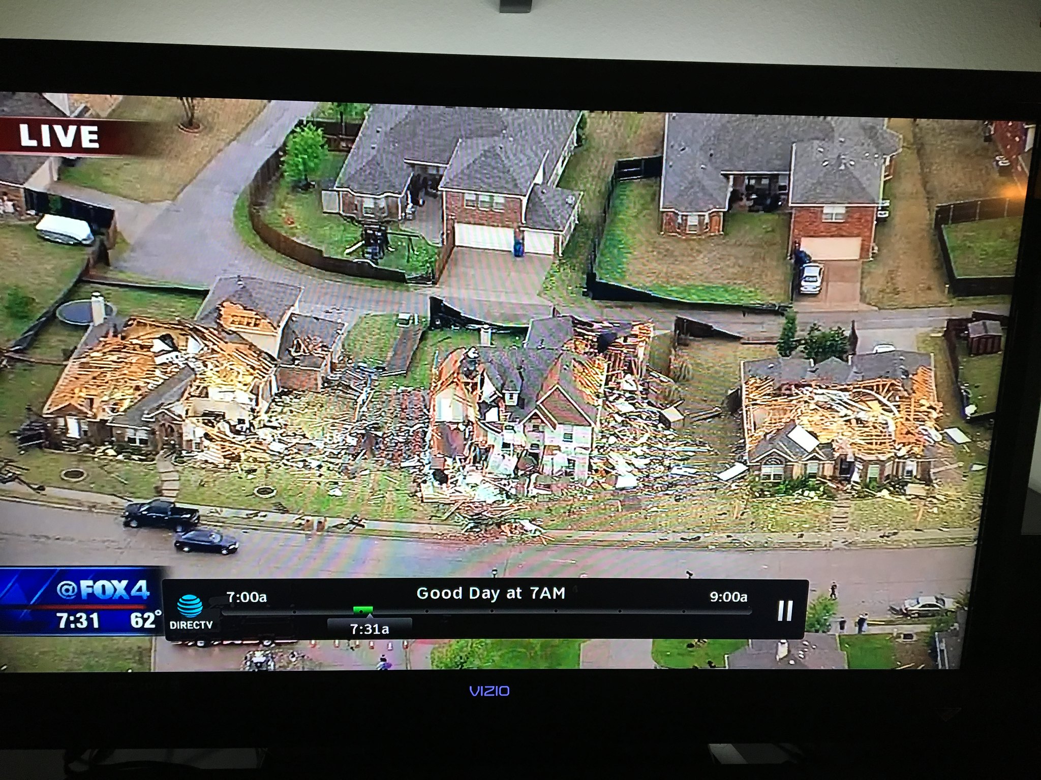
I would not be shocked. Considering the extent of damage. Here's a pic for those that haven't seen it.
0 likes
Re: Texas Spring 2017 | ENH for East Texas
Yikes!  no good about that damage, hope everyone was safe.
Got 1.53in here in my back yard. I'm a happy rain miser today.
no good about that damage, hope everyone was safe.Got 1.53in here in my back yard. I'm a happy rain miser today.
1 likes
Resident Rain Miser
I am a weather hobbyist living 3.5 miles south of Downtown Austin and in no way or fashion should anything I say concerning forecasts be taken seriously. Please check your local NWS for accurate weather forecasting and conditions.
I am a weather hobbyist living 3.5 miles south of Downtown Austin and in no way or fashion should anything I say concerning forecasts be taken seriously. Please check your local NWS for accurate weather forecasting and conditions.
-
gboudx
- S2K Supporter
- Posts: 4090
- Joined: Thu Sep 04, 2003 1:39 pm
- Location: Rockwall, Tx but from Harvey, La
Re: Texas Spring 2017 | ENH for East Texas
NWS put this out:
http://www.weather.gov/images/fwd/graph ... _full1.gif
Zoom in. The damage occurred under the "y" in Wylie. The line bows hard right there with a gust front blasting ahead.
http://www.weather.gov/images/fwd/graph ... _full1.gif
Zoom in. The damage occurred under the "y" in Wylie. The line bows hard right there with a gust front blasting ahead.
0 likes
-
Lagreeneyes03
- Category 2

- Posts: 609
- Joined: Mon Dec 09, 2013 10:53 am
- Location: Luxurious Lake Grapevine
Re: Texas Spring 2017 | ENH for East Texas
I have a question about last night's storms, hopefully someone can answer.
In my area, we seemed to be right in between 2 of the tornado warnings that were in NE Tarrant county. I'm in Grapevine. There was one 5-10 miles north of me, and one 4-8 miles south of me. So much of the metroplex got heavy wind damage. In my neighborhood and it seems within a 2-3 mile radius, we barely even had leaves blow off the trees. My pool was almost completely free of leaves/debris in the morning, and while the storms were going on, I noted that the trees were barely moving. We had a ton of rain, and the rest, but I don't think the winds topped 15 MPH at my house..
Was I in the middle of some weird "eye" type phenomena in regards to wind and being between two circulations/rotations?
It was the strangest thing.
0 likes
I'm a Princess, not a forecaster.
Re: Texas Spring 2017 | MDT for Wichita/Abilene area
gboudx wrote:Brent wrote:Looks like a tornado in Rockwall from earlier?
They're saying it was straight-line winds. Perhaps a microburst since home damage was concentrated over such a small area. But I'm sure the NWS will be out here to investigate. The worst of it is about 2-3 miles east of me.
Edit: Are the weather sirens supposed to go off for a Severe T-storm warning, as well as, Tornado? We heard no siren.
In my calls to the City of Dallas, our sirens are Outdoor Warning Sirens and are only intended to be heard outside; it might be the same with Rockwall.
On a sidenote, I found this somewhat humorous tweet about one of Keller's sirens:
https://twitter.com/kellerpolice/status/847140815684222984
0 likes
Return to “USA & Caribbean Weather”
Who is online
Users browsing this forum: No registered users and 88 guests