
An area of disturbed weather has persisted over the SE GOM and Yucatan Straits the last several days. It's real early in the season to get something started but global models like the GFS form a weak low that moves NE across Florida into the SE Atlantic where it intensifies. Something to watch for on STS development once in the Atlantic.
http://www.ssd.noaa.gov/goes/east/gmex/rb-animated.gif
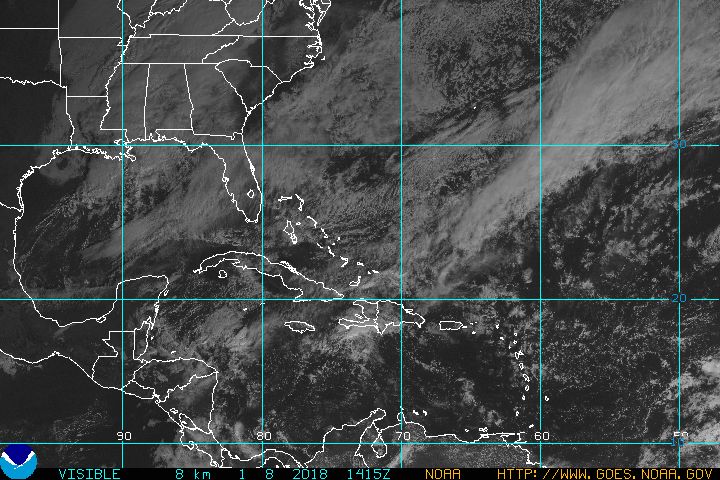
Disturbance in SE GOM
Moderator: S2k Moderators
Forum rules

The posts in this forum are NOT official forecasts and should not be used as such. They are just the opinion of the poster and may or may not be backed by sound meteorological data. They are NOT endorsed by any professional institution or STORM2K. For official information, please refer to products from the National Hurricane Center and National Weather Service.
Disturbance in SE GOM
1 likes
-
weathaguyry

- Category 5

- Posts: 1273
- Age: 22
- Joined: Wed Jun 15, 2016 5:16 am
- Location: Long Island, NY
Re: Disturbance in SE GOM
This is actually pretty interesting, even though the models don't make that much out of it, it seems that the wind shear will drop off pretty rapidly right off of the NC coast. For sure something to watch.
1 likes
My posts are only my opinions and NOT official forecasts. For official forecasts, consult the National Hurricane Center or the National Weather Service.
Irene 11', Sandy 12', Fay 20’, Isaias 20’, Elsa 21’, Henri 21’, Ida 21’
Irene 11', Sandy 12', Fay 20’, Isaias 20’, Elsa 21’, Henri 21’, Ida 21’
-
Florida1118
Re: Disturbance in SE GOM


Certainly looks like some sort of feature will be coming out of this mess in combination with the front.
1 likes
-
TheStormExpert
Re: Disturbance in SE GOM
Was about to say yesterday that this could be worthy of it's own thread, either way the peninsula of Florida should see some MUCH NEEDED rain from this starting late Saturday and going into Monday.
1 likes
-
TheStormExpert
Re: Disturbance in SE GOM
Not much to look at now, but if this were to occur 4-6 weeks from now this would have a decent shot IMO at becoming our typical early season lopsided tropical cyclone.
Would be surprised if we didn't see one this year as this is probably going to be the hotspot this season in the W. Caribbean and Gulf of Mexico.

Would be surprised if we didn't see one this year as this is probably going to be the hotspot this season in the W. Caribbean and Gulf of Mexico.
1 likes
-
gatorcane

- S2K Supporter

- Posts: 23708
- Age: 48
- Joined: Sun Mar 13, 2005 3:54 pm
- Location: Boca Raton, FL
Re: Disturbance in SE GOM
Latest EC has it merging with some kind of upper-level feature near the SE US Coast, wonder if this thing will have a shot once it passes Florida to become something north of the Bahamas off SE US coast?

0 likes

Re: Disturbance in SE GOM

You can see the weak disturbance (green circle) where the thin blue lines are (those show rising motion). It's gonna merge with the larger trough and maybe help kick off the east coast storm/cyclone. Can't see it having time to develop into anything (sub)tropical.
1 likes
-
AJC3

- Admin

- Posts: 4156
- Age: 62
- Joined: Tue Aug 31, 2004 7:04 pm
- Location: Ballston Spa, New York
- Contact:
Re: Disturbance in SE GOM
A mid to upper level low is producing some baroclinic lowering of pressures down in that area. Currently a surface trough is being analyzed from the Yucatan Channel extending south and southeast into the NW Caribbean sea. You can even see a small transient vortex just NE of Cozumel on visible imagery right now.
This whole sloppy mess is forecast to eject northeast across western Cuba, the Florida Straits and southernmost Florida Saturday night into Sunday. A decent moisture plume should extend farther E-SE over much of the Greater Antilles, so some decent rains seem likely there as well. Around that same time, a northern stream trough dropping into the SE U.S. should induce and even stronger baroclinic low to form along the SE seaboard, which should combine with/absorb the slop to its south, and then head NE near/along the Carolina coast and points NE.
We had been hoping for some decent rains farther north into central Florida from this system, but that remains in question. At least south Florida should get some much needed rainfall out of this.
0 likes
-
northjaxpro

- S2K Supporter
- Posts: 8900
- Joined: Mon Sep 27, 2010 11:21 am
- Location: Jacksonville, FL
Re: Disturbance in SE GOM
1012 mb Low Pressure area being analyzed by NHC and WPC. Right now, this system at this time appears to be not in any hurry to eject to the northeast. I just hope this system brings South Florida at least some much needed rain the next couple of days. The peninsula as a whole needs rain desperately right now.
1 likes
NEVER, EVER SAY NEVER in the tropics and weather in general, and most importantly, with life itself!!
________________________________________________________________________________________
Fay 2008 Beryl 2012 Debby 2012 Colin 2016 Hermine 2016 Julia 2016 Matthew 2016 Irma 2017 Dorian 2019
________________________________________________________________________________________
Fay 2008 Beryl 2012 Debby 2012 Colin 2016 Hermine 2016 Julia 2016 Matthew 2016 Irma 2017 Dorian 2019
-
OuterBanker
- S2K Supporter
- Posts: 1761
- Joined: Wed Feb 26, 2003 10:53 am
- Location: Nags Head, NC
- Contact:
Re: Disturbance in SE GOM
Latest model runs are pretty much in agreement. All having a low pressure on the Outer banks in the 1000mb range. Difference so far is the speed, latest 12Z run of the GFS is around 80 hrs, CMC and Euro around 96hrs which means it will be much further north and east of us by wed 12z if the latest GFS is correct. I am hoping for the GFS run because of the rain expected. Morehead city latest discuss mentions three to six inches of rain here. After dealing with the flood of Matthew and all the repair and reconstruct I’m now nervous anytime copious amounts of rain are predicted. AJ I know you would appreciate the rain much more than us.
1 likes

Re: Disturbance in SE GOM
Outflow has expanded to the west of this. This is looking better than I thought it would
If this were June, we'd for sure have a storm out of this
If this were June, we'd for sure have a storm out of this
0 likes
Re: Disturbance in SE GOM
Fantastic rainfall over south and portions of east central florida from this. A true blessing for those regions. Looks to be sufficient to move the needle on the US drought monitor in some of those areas.
1 likes
-
OuterBanker
- S2K Supporter
- Posts: 1761
- Joined: Wed Feb 26, 2003 10:53 am
- Location: Nags Head, NC
- Contact:
Re: Disturbance in SE GOM
US model (GFS) is going with the ULL merging with the Atlantic low and moving up the coast. While the Euro is seeing the Atlantic low as dominant. pinwheeling into the NC coast somewhere between Lookout and Hatteras. Euro is quite a bit stronger with winds near hurricane gusts along the Outer Banks. We will see who is right. No doubt it will not be named even if it goes warm core. Funny, the TPC will name an anomaly in the middle of the ocean, but not something close to home. Will the real Arlene please stand up.
0 likes
-
HurricaneBelle

- S2K Supporter
- Posts: 1209
- Joined: Sun Aug 27, 2006 6:12 pm
- Location: Clearwater, FL
Re: Disturbance in SE GOM
0 likes

Re: Disturbance in SE GOM
Outer band from the system giving us some rain and wind. Nothing more than an average front, really.
0 likes
Igor 2010, Sandy 2012, Fay 2014, Gonzalo 2014, Joaquin 2015, Nicole 2016, Humberto 2019, Imelda 2025
I am only a tropical weather enthusiast. My predictions are not official and may or may not be backed by sound meteorological data. For official information, please refer to the NHC and NWS products.
I am only a tropical weather enthusiast. My predictions are not official and may or may not be backed by sound meteorological data. For official information, please refer to the NHC and NWS products.
Who is online
Users browsing this forum: Google Adsense [Bot] and 100 guests