2017 indicators: SST's / MSLP / SAL / Steering / Instability
Moderator: S2k Moderators
Forum rules

The posts in this forum are NOT official forecasts and should not be used as such. They are just the opinion of the poster and may or may not be backed by sound meteorological data. They are NOT endorsed by any professional institution or STORM2K. For official information, please refer to products from the National Hurricane Center and National Weather Service.
-
Hurricaneman

- Category 5

- Posts: 7404
- Age: 45
- Joined: Tue Aug 31, 2004 3:24 pm
- Location: central florida
Re: 2017 indicators: SST's / MSLP / SAL / Steering / Instability
One thing I'm noticing is that the CFSv2 model is very consistent on showing an bit of activity in June and possibly a very active July but what about August and September
0 likes

Re: 2017 indicators: SST's / MSLP / SAL / Steering / Instability
Hammy wrote:
CFS July forecast showing potentially three separate tracks--while this is still quite a ways out and I don't necessarily think these exact paths would be followed, could this be an indicator that July could be somewhat more active than in the last several years?

To "piggy-back" on Hammy (pun unintended but hey, it is kinda funny), it's this type of set up, anomalous warm Atlantic SST's, and the relevance of this season being the second year following a major El Nino event that I believe we'll see such a heightened number of storms and a significant increase in their overall intensity for this upcoming season. Numbers are just numbers except when those numbers result in any form of dangerous impact on life and property. I'm really concerned for area's within the W. Caribbean, Central America, and Gulf of Mexico. Long range condition unpredictability limits our ability to measure the risk whether several major hurricanes might move into or develop in the Caribbean or GOM, however IF a set up for a concentration of far W. Atlantic genesis or an overall westward set of storm tracks were to occur than I see a greater than average potential for severe storm related flooding (especially in those further south latitudes South of 20N). If overall greater storm intensities were to play out this year than I'd be particularly concerned about the impact that storm surge would have on coastal regions especially prone to such risk, yet are many years removed since the last time they were really tested.
While many continue to debate the whole El Nino paradigm, I just don't see it materializing in any significant manner nor believe that the Atlantic will be impacted by any significant ENSO related conditions. Of course a neutral ENSO is not a given but assuming we see a total departure from hostile El Nino conditions and also minus the relentless and amplified meridional 200mb flow, its not unreasonable for the Atlantic to have a big post Nino rebound year. Beyond this I strongly believe that other "Wild-Card" conditions which have impacted the Atlantic basin during recent years will largely factor in just how active and deadly the 2017 season will become. Not only do I think 2017 will in no way be under-active year or simply display average activity but am basically torn whether 2017 will be defined as an above average and busy hurricane season or a hyper-active season, and whether 2017 will prove deadly for some, or for a particular region, or affecting the many over large distances.
How much of an impact will Saharan dust or dry mid-level capping have? Will the Atlantic MDR and the ITCZ as a whole be impacted by basin wide repressed surface convergence as a result of anomalously high surface pressure heights (as suggested by the EURO)? What about steering and how the long wave pattern will set up this year? Finally, what about the "Ninel Effect"? Has his departure from S2K resulted in a greater E. CONUS threat (
All in all, I believe the greatest risks will be to those in Central America, Yucatan, Texas and potentially the Northern Gulf as well. As for the Mid-Atlantic, I'd guess this year would pose less threat from lower latitude "westward tracking storms" but possibly a greater threat from close in and "locally brewed" systems that form and potentially become blocked and perhaps move quickly inland or north along the US (and Canadian?) coastline. All that, then throw in at least 2 or 3 presumptive East/Central Atlantic re-curves, perhaps one or two errant mid to late September T.S. or minimal hurricane threats to the Florida East coast when late season steering heights begins to break down, and that's my "3-cent" take on how this season might play out.
1 likes
Andy D
(For official information, please refer to the NHC and NWS products.)
(For official information, please refer to the NHC and NWS products.)
-
TheStormExpert
Re: 2017 indicators: SST's / MSLP / SAL / Steering / Instability
Curious, because I know I've heard over a dozen times on here on how the second year after an El Niño can feature an active season as well as at least one big U.S. impact.
1 likes
-
weathaguyry

- Category 5
- Posts: 1273
- Age: 22
- Joined: Wed Jun 15, 2016 5:16 am
- Location: Long Island, NY
Re: 2017 indicators: SST's / MSLP / SAL / Steering / Instability
chaser1 wrote:Hammy wrote:
CFS July forecast showing potentially three separate tracks--while this is still quite a ways out and I don't necessarily think these exact paths would be followed, could this be an indicator that July could be somewhat more active than in the last several years?
To "piggy-back" on Hammy (pun unintended but hey, it is kinda funny), it's this type of set up, anomalous warm Atlantic SST's, and the relevance of this season being the second year following a major El Nino event that I believe we'll see such a heightened number of storms and a significant increase in their overall intensity for this upcoming season. Numbers are just numbers except when those numbers result in any form of dangerous impact on life and property. I'm really concerned for area's within the W. Caribbean, Central America, and Gulf of Mexico. Long range condition unpredictability limits our ability to measure the risk whether several major hurricanes might move into or develop in the Caribbean or GOM, however IF a set up for a concentration of far W. Atlantic genesis or an overall westward set of storm tracks were to occur than I see a greater than average potential for severe storm related flooding (especially in those further south latitudes South of 20N). If overall greater storm intensities were to play out this year than I'd be particularly concerned about the impact that storm surge would have on coastal regions especially prone to such risk, yet are many years removed since the last time they were really tested.
While many continue to debate the whole El Nino paradigm, I just don't see it materializing in any significant manner nor believe that the Atlantic will be impacted by any significant ENSO related conditions. Of course a neutral ENSO is not a given but assuming we see a total departure from hostile El Nino conditions and also minus the relentless and amplified meridional 200mb flow, its not unreasonable for the Atlantic to have a big post Nino rebound year. Beyond this I strongly believe that other "Wild-Card" conditions which have impacted the Atlantic basin during recent years will largely factor in just how active and deadly the 2017 season will become. Not only do I think 2017 will in no way be under-active year or simply display average activity but am basically torn whether 2017 will be defined as an above average and busy hurricane season or a hyper-active season, and whether 2017 will prove deadly for some, or for a particular region, or affecting the many over large distances.
How much of an impact will Saharan dust or dry mid-level capping have? Will the Atlantic MDR and the ITCZ as a whole be impacted by basin wide repressed surface convergence as a result of anomalously high surface pressure heights (as suggested by the EURO)? What about steering and how the long wave pattern will set up this year? Finally, what about the "Ninel Effect"? Has his departure from S2K resulted in a greater E. CONUS threat ()? I think some of these other factors will largely dictate how the Atlantic hurricane season plays out.
All in all, I believe the greatest risks will be to those in Central America, Yucatan, Texas and potentially the Northern Gulf as well. As for the Mid-Atlantic, I'd guess this year would pose less threat from lower latitude "westward tracking storms" but possibly a greater threat from close in and "locally brewed" systems that form and potentially become blocked and perhaps move quickly inland or north along the US (and Canadian?) coastline. All that, then throw in at least 2 or 3 presumptive East/Central Atlantic re-curves, perhaps one or two errant mid to late September T.S. or minimal hurricane threats to the Florida East coast when late season steering heights begins to break down, and that's my "3-cent" take on how this season might play out.
I agree 100%, with +PDO and favorable SOI, El-Nino would have already formed by now, or it would at least be very evident that it was going to form, but we are now in May, there is still a sub-surface cold pool, and Nino 4 just cooled off. My concern is some of those storms that ride all the way up the coast, if something like Gloria 1985/Donna 1960, or even the 1938 hurricane happened again, it would be absolutely devastating for our area, even though Sandy was bad, it probably had flooding similar to a respectable Cat 2 hurricane, if a Major were to rush up the coast and smash into NYC, that would be absolutely horrendous! I went with 16/8/4 for my numbers, which seem fair, this may be the first "quality over quantity" season we've had in a long time!!! (Not to Mention both Gloria and Donna happened 2 years after an El-Nino
0 likes
My posts are only my opinions and NOT official forecasts. For official forecasts, consult the National Hurricane Center or the National Weather Service.
Irene 11', Sandy 12', Fay 20’, Isaias 20’, Elsa 21’, Henri 21’, Ida 21’
Irene 11', Sandy 12', Fay 20’, Isaias 20’, Elsa 21’, Henri 21’, Ida 21’


Re: 2017 indicators: SST's / MSLP / SAL / Steering / Instability
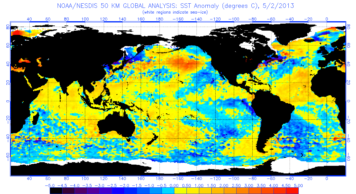
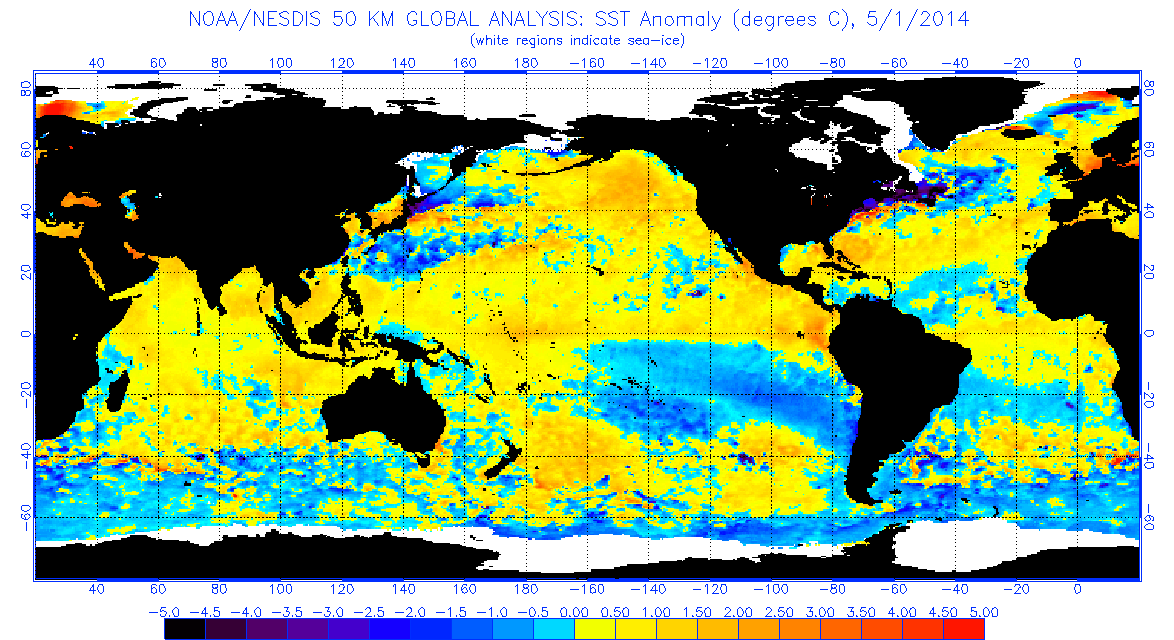
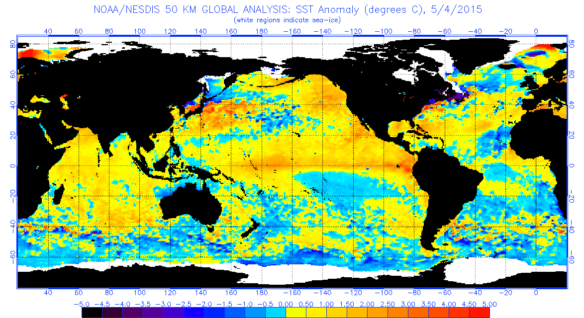
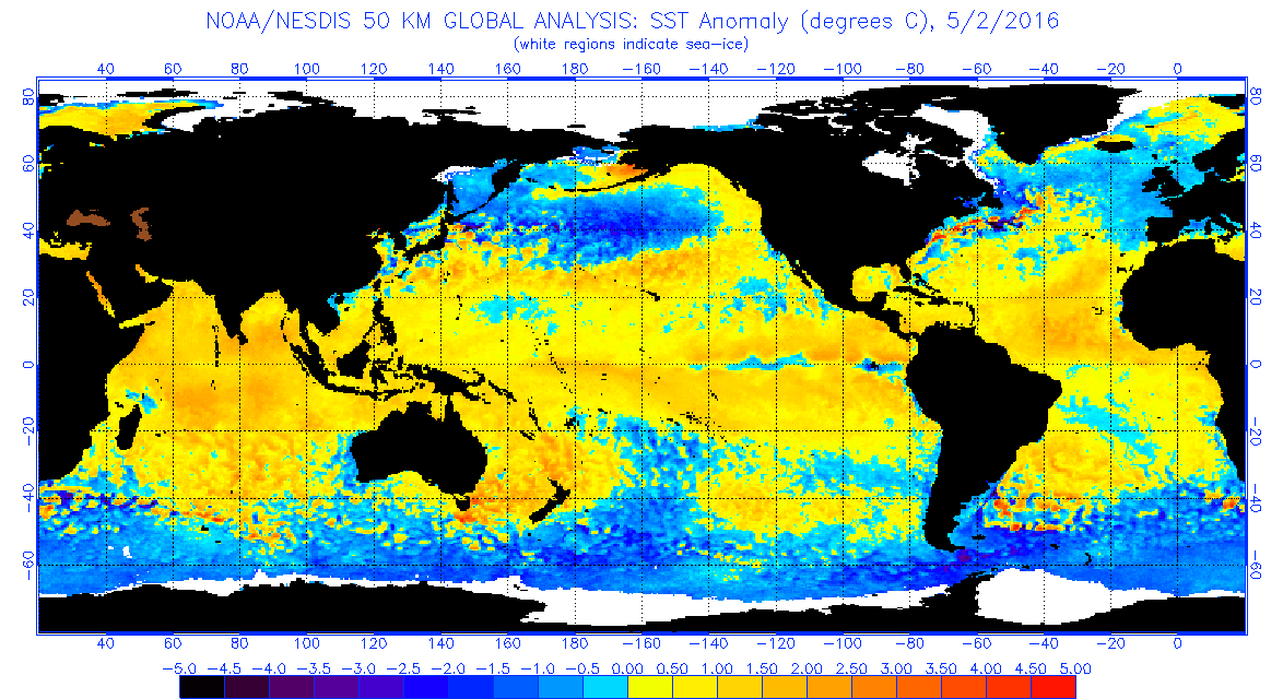
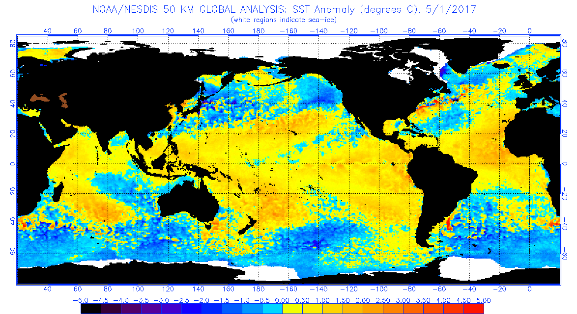
TheStormExpert wrote::uarrow: Here are the last several years SST's Anomalies at the beginning of May just for comparison. In fact the Tropical Atlantic looks to be the warmest it's been in years! Though that could mean very little as it all depends on what the vertical instability and wind shear looks like. The thing that sticks out the most is the cool strip stretching from the extreme SW Atlantic northeast into the Central North Atlantic, looks to be the coolest it's been since 2013, what could that mean?
2013
http://www.ospo.noaa.gov/data/sst/anoma ... 2.2013.gif
2014
http://www.ospo.noaa.gov/data/sst/anoma ... 1.2014.gif
2015
http://www.ospo.noaa.gov/data/sst/anoma ... 4.2015.gif
2016
http://www.ospo.noaa.gov/data/sst/anoma ... 2.2016.gif
2017
http://www.ospo.noaa.gov/data/sst/anoma ... 1.2017.gif[/img]
The interesting thing about these maps that you can take is look at 2013 and 2016. Both had warming MDR but very different opposite results. Which is telling that it alone cannot foresee a very active season. Caution is always advised when using anomalies for a certain period to project, as one must remember, it is almost always warm enough for big hurricanes all season in most parts of the Atlantic where they historically happen. In context with the spatial SST anomalies pattern can be more helpful.
1 likes
The above post and any post by Ntxw is NOT an official forecast and should not be used as such. It is just the opinion of the poster and may or may not be backed by sound meteorological data. It is NOT endorsed by any professional institution including Storm2k. For official information, please refer to NWS products.
Help support Storm2K!
-
WeatherEmperor
- S2K Supporter

- Posts: 4806
- Age: 42
- Joined: Thu Sep 04, 2003 2:54 pm
- Location: South Florida
Re: 2017 indicators: SST's / MSLP / SAL / Steering / Instability
There was some talk in the ENSO thread about a WWB taking place sometime early to mid May which would get the Nino going. Can somebody post forecast maps for WWB's so we can see whats happening there? Also, maybe Luis can post the latest Euro sea level pressure forecast for the ATL?
Sent from my iPhone 7 using Tapatalk
Sent from my iPhone 7 using Tapatalk
0 likes
-
TheStormExpert
Re: 2017 indicators: SST's / MSLP / SAL / Steering / Instability
Ntxw wrote:TheStormExpert wrote::uarrow: Here are the last several years SST's Anomalies at the beginning of May just for comparison. In fact the Tropical Atlantic looks to be the warmest it's been in years! Though that could mean very little as it all depends on what the vertical instability and wind shear looks like. The thing that sticks out the most is the cool strip stretching from the extreme SW Atlantic northeast into the Central North Atlantic, looks to be the coolest it's been since 2013, what could that mean?
2013
http://www.ospo.noaa.gov/data/sst/anoma ... 2.2013.gif
2014
http://www.ospo.noaa.gov/data/sst/anoma ... 1.2014.gif
2015
http://www.ospo.noaa.gov/data/sst/anoma ... 4.2015.gif
2016
http://www.ospo.noaa.gov/data/sst/anoma ... 2.2016.gif
2017
http://www.ospo.noaa.gov/data/sst/anoma ... 1.2017.gif[/img]
The interesting thing about these maps that you can take is look at 2013 and 2016. Both had warming MDR but very different opposite results. Which is telling that it alone cannot foresee a very active season. Caution is always advised when using anomalies for a certain period to project, as one must remember, it is almost always warm enough for big hurricanes all season in most parts of the Atlantic where they historically happen. In context with the spatial SST anomalies pattern can be more helpful.
2013 of course had cooler waters in the equatorial east pacific. 2013 and 2017 are different in several ways just looking at the maps.
0 likes
Re: 2017 indicators: SST's / MSLP / SAL / Steering / Instability
0 likes
The above post and any post by Ntxw is NOT an official forecast and should not be used as such. It is just the opinion of the poster and may or may not be backed by sound meteorological data. It is NOT endorsed by any professional institution including Storm2k. For official information, please refer to NWS products.
Help support Storm2K!
Help support Storm2K!
-
cycloneye

- Admin

- Posts: 149431
- Age: 69
- Joined: Thu Oct 10, 2002 10:54 am
- Location: San Juan, Puerto Rico
Re: 2017 indicators: SST's / MSLP / SAL / Steering / Instability
WeatherEmperor wrote:There was some talk in the ENSO thread about a WWB taking place sometime early to mid May which would get the Nino going. Can somebody post forecast maps for WWB's so we can see whats happening there? Also, maybe Luis can post the latest Euro sea level pressure forecast for the ATL?
Sent from my iPhone 7 using Tapatalk
The ECMWF MSLP monthly updates are released to the public on every 15 of every month so we will wait for that date.
0 likes
Visit the Caribbean-Central America Weather Thread where you can find at first post web cams,radars
and observations from Caribbean basin members Click Here
and observations from Caribbean basin members Click Here
-
TheStormExpert
Re: 2017 indicators: SST's / MSLP / SAL / Steering / Instability
Really this season could go either way depending on how everything evolves as we head into the season.
It could be a dud like 2013 or it could be an extremely active or even hyperactive season with numbers similar to that of 2010, 2011, and 2012.
2005 is a once in a lifetime season and should not be used as an analog unless you're looking only at it to get an idea as to what storm tracks might look like. This season in my opinion at the moment may very well have similar storm tracks, especially if the Tropical Atlantic is dead and unfavorable.
I'm leaning for now with a mix of both with a near average season occurring with higher than normal in-close development.
The steering pattern seems somewhat different than last season with a more progressive pattern currently going on across this part of the world. Whether this sticks throughout the summer is yet to be seen. But if it does you will likely have a trough swinging through the Eastern U.S. every now and then, more frequently than last season where more ridging was established across the Eastern U.S.
1 likes
-
weathaguyry
- Category 5
- Posts: 1273
- Age: 22
- Joined: Wed Jun 15, 2016 5:16 am
- Location: Long Island, NY
Re: 2017 indicators: SST's / MSLP / SAL / Steering / Instability
TheStormExpert wrote:Really this season could go either way depending on how everything evolves as we head into the season.
It could be a dud like 2013 or it could be an extremely active or even hyperactive season with numbers similar to that of 2010, 2011, and 2012.
2005 is a once in a lifetime season and should not be used as an analog unless you're looking only at it to get an idea as to what storm tracks might look like. This season in my opinion at the moment may very well have similar storm tracks, especially if the Tropical Atlantic is dead and unfavorable.
I'm leaning for now with a mix of both with a near average season occurring with higher than normal in-close development.
The steering pattern seems somewhat different than last season with a more progressive pattern currently going on across this part of the world. Whether this sticks throughout the summer is yet to be seen. But if it does you will likely have a trough swinging through the Eastern U.S. every now and then, more frequently than last season where more ridging was established across the Eastern U.S.
I agree, here on Long Island, we had a lot of scares over the last few years, with Joaquin, Hermine, and Matthew for a period of time. This year it looks like that protective ridge will not be in place to protect us as much.
0 likes
My posts are only my opinions and NOT official forecasts. For official forecasts, consult the National Hurricane Center or the National Weather Service.
Irene 11', Sandy 12', Fay 20’, Isaias 20’, Elsa 21’, Henri 21’, Ida 21’
Irene 11', Sandy 12', Fay 20’, Isaias 20’, Elsa 21’, Henri 21’, Ida 21’
-
gatorcane

- S2K Supporter
- Posts: 23708
- Age: 48
- Joined: Sun Mar 13, 2005 3:54 pm
- Location: Boca Raton, FL
Re: 2017 indicators: SST's / MSLP / SAL / Steering / Instability
TheStormExpert wrote:The steering pattern seems somewhat different than last season with a more progressive pattern currently going on across this part of the world. Whether this sticks throughout the summer is yet to be seen. But if it does you will likely have a trough swinging through the Eastern U.S. every now and then, more frequently than last season where more ridging was established across the Eastern U.S.
Yes, I agree last year we were talking about long sustaining ridges around this time with very stout Bermuda High. So far this spring the Bermuda High does not seem particularly long-lasting, definitely a more progressive pattern. We'll see how the rest of May goes and whether we see a persistent east wind pattern in South Florida we saw a lot of last summer early on which ended up resulting in stronger than expected ridging over the W. Atlantic later in the season (i.e. models underestimating the strength of the Bermuda High for Matthew). It still all comes down to El Nino, if that does not materialize, this season is looking quite active to me, more so than last season because of warmer SSTs, second year after El Nino, residual latent heat build-up in the atmosphere from 2015 El Nino.
1 likes

Re: 2017 indicators: SST's / MSLP / SAL / Steering / Instability
The weakness of the Bermuda-Azores ridge this year could result in fewer Cape Verde-type hurricanes that affect land. So I think that if a storm were to affect land (most notably the US) it would develop closer to it. So track-wise, I'm expecting a season similar to 2005 with little MDR activity, aside from a couple fish, perhaps.
2 likes
Igor 2010, Sandy 2012, Fay 2014, Gonzalo 2014, Joaquin 2015, Nicole 2016, Humberto 2019, Imelda 2025
I am only a tropical weather enthusiast. My predictions are not official and may or may not be backed by sound meteorological data. For official information, please refer to the NHC and NWS products.
I am only a tropical weather enthusiast. My predictions are not official and may or may not be backed by sound meteorological data. For official information, please refer to the NHC and NWS products.
-
weathaguyry
- Category 5
- Posts: 1273
- Age: 22
- Joined: Wed Jun 15, 2016 5:16 am
- Location: Long Island, NY
Re: 2017 indicators: SST's / MSLP / SAL / Steering / Instability

0 likes
My posts are only my opinions and NOT official forecasts. For official forecasts, consult the National Hurricane Center or the National Weather Service.
Irene 11', Sandy 12', Fay 20’, Isaias 20’, Elsa 21’, Henri 21’, Ida 21’
Irene 11', Sandy 12', Fay 20’, Isaias 20’, Elsa 21’, Henri 21’, Ida 21’
-
MGC

- S2K Supporter
- Posts: 5940
- Joined: Sun Mar 23, 2003 9:05 pm
- Location: Pass Christian MS, or what is left.
Re: 2017 indicators: SST's / MSLP / SAL / Steering / Instability
Y'all are putting too much emphasis on SST. The tropical waters of the Atlantic basin are always warm enough to support major hurricanes in the heart of the season. Dry air and shear are the cane killers. I'm hedging my bets that a weak El Nino develops this season.....MGC
3 likes
-
AutoPenalti
- Category 5
- Posts: 4091
- Age: 29
- Joined: Mon Aug 17, 2015 4:16 pm
- Location: Ft. Lauderdale, Florida
Re: 2017 indicators: SST's / MSLP / SAL / Steering / Instability
MGC wrote:Y'all are putting too much emphasis on SST. The tropical waters of the Atlantic basin are always warm enough to support major hurricanes in the heart of the season. Dry air and shear are the cane killers. I'm hedging my bets that a weak El Nino develops this season.....MGC
What's the prognosis on steering and dry air for the coming months?
0 likes
The posts in this forum are NOT official forecasts and should not be used as such. They are just the opinion of the poster and may or may not be backed by sound meteorological data. They are NOT endorsed by any professional institution or STORM2K. For official information, please refer to products from the NHC and NWS.
Model Runs Cheat Sheet:
GFS (5:30 AM/PM, 11:30 AM/PM)
HWRF, GFDL, UKMET, NAVGEM (6:30-8:00 AM/PM, 12:30-2:00 AM/PM)
ECMWF (1:45 AM/PM)
TCVN is a weighted averaged
-
Kingarabian

- S2K Supporter
- Posts: 16360
- Joined: Sat Aug 08, 2009 3:06 am
- Location: Honolulu, Hawaii
Re: 2017 indicators: SST's / MSLP / SAL / Steering / Instability
MGC wrote:Y'all are putting too much emphasis on SST. The tropical waters of the Atlantic basin are always warm enough to support major hurricanes in the heart of the season. Dry air and shear are the cane killers. I'm hedging my bets that a weak El Nino develops this season.....MGC
Precisely this. Waters in the Atlantic and the GOM will ALWAYS be favorable for TC development.
As Ntxw has pointed out in the ENSO thread, the background state of the planet is nowhere near Nina (to promote an above average/average hurricane season) and it's still in a Nino state. A warm PDO, plenty of warm waters in the Pacific, a tanking SOI, and now successive WWB's ... unless these change it'll be hard in my opinion to forecast an above average season in the Atlantic. But we know numbers don't matter for the Atlantic. A disturbance in the right area at the right time can be devastating and can generate a lot of ACE.
1 likes
RIP Kobe Bryant
-
WeatherEmperor
- S2K Supporter
- Posts: 4806
- Age: 42
- Joined: Thu Sep 04, 2003 2:54 pm
- Location: South Florida
2017 indicators: SST's / MSLP / SAL / Steering / Instability
@kingarabian,
I think some are not convinced the oncoming El Nino will affect the heart of the hurricane season and that it wont fully mature until Fall/Winter. In your opinion will the El Nino come during the Summer or later?
Sent from my iPhone 7 using Tapatalk
I think some are not convinced the oncoming El Nino will affect the heart of the hurricane season and that it wont fully mature until Fall/Winter. In your opinion will the El Nino come during the Summer or later?
Sent from my iPhone 7 using Tapatalk
0 likes
Re: 2017 indicators: SST's / MSLP / SAL / Steering / Instability
WeatherEmperor wrote:@kingarabian,
I think some are not convinced the oncoming El Nino will affect the heart of the hurricane season and that it wont fully mature until Fall/Winter. In your opinion will the El Nino come during the Summer or later?
Sent from my iPhone 7 using Tapatalk
There doesn't need to be an official El Nino for there to be El Nino like effects. Of course nothing like the 60-90kts of shear in the Caribb like in 2015 but more times than not the atmosphere may behave as one. A lot of caution needs to be advised as it is more intricate than simply if there is an El Nino or not. The walker cell in the tropical Pacific is just as important. If air is consistently rising in the Pacific (much like during nino's) then dry air and or shear will poke it's nose more often than not. If there is sinking air in the Pacific (much like in a Nina) then rising air or moist, less shear for the Atlantic. And it doesn't necessarily need ENSO to oscillate, the stronger the ENSO event then the more influence it has, other factors such as MJO state or background state of the subtropics can induce as well.
2016 was a fairly easy forecast considering the parameters as most outlets and even here on storm2k the collective unit did well. This is because of the forecast of some kind of Nina coming on and creating those more favorable conditions (sinking air over the Pacific). There is no Nina this year, so it is a little more muddled. it doesn't mean that the positive neutral or Nino will shut down the season, it's just more question marks than answers.
1 likes
The above post and any post by Ntxw is NOT an official forecast and should not be used as such. It is just the opinion of the poster and may or may not be backed by sound meteorological data. It is NOT endorsed by any professional institution including Storm2k. For official information, please refer to NWS products.
Help support Storm2K!
Help support Storm2K!
-
Kingarabian
- S2K Supporter
- Posts: 16360
- Joined: Sat Aug 08, 2009 3:06 am
- Location: Honolulu, Hawaii
Re: 2017 indicators: SST's / MSLP / SAL / Steering / Instability
WeatherEmperor wrote:@kingarabian,
I think some are not convinced the oncoming El Nino will affect the heart of the hurricane season and that it wont fully mature until Fall/Winter. In your opinion will the El Nino come during the Summer or later?
Sent from my iPhone 7 using Tapatalk
Other than the current and nagging cold pool in the subsurface, I think the other ENSO variables (mentioned on this thread and the ENSO thread) are falling in line in terms of seeing an El-Nino. I don't know if we'll have an official Nino numbers wise but Nino conditions will be present. Things could definitely change if that cold pool manges to reach the surface and cool the Nino regions (although I doubt it since we're seeing successive WWB's which should theoretically ward it off and allow the warm pool to the west to take over).
0 likes
RIP Kobe Bryant
Who is online
Users browsing this forum: No registered users and 71 guests