2017 indicators: SST's / MSLP / SAL / Steering / Instability

This is the general tropical discussion area. Anyone can take their shot at predicting a storms path.

Moderator: S2k Moderators

Forum rules

The posts in this forum are NOT official forecasts and should not be used as such. They are just the opinion of the poster and may or may not be backed by sound meteorological data. They are NOT endorsed by any professional institution or STORM2K. For official information, please refer to products from the National Hurricane Center and National Weather Service.

Help Support Storm2K
Message
Author
User avatar
Yellow Evan
Professional-Met
Professional-Met
Posts: 16143
Age: 27
Joined: Fri Jul 15, 2011 12:48 pm
Location: Henderson, Nevada/Honolulu, HI
Contact:

Re: 2017 indicators: SST's / MSLP / SAL / Steering / Instability

#201 Postby Yellow Evan » Tue May 02, 2017 8:13 pm

WeatherEmperor wrote:@kingarabian,

I think some are not convinced the oncoming El Nino will affect the heart of the hurricane season and that it wont fully mature until Fall/Winter. In your opinion will the El Nino come during the Summer or later?


Sent from my iPhone 7 using Tapatalk


I also think people are overestimating the time it takes for the atmosphere to enter an El Nino base state.
0 likes   

User avatar
Hurricaneman
Category 5
Category 5
Posts: 7351
Age: 45
Joined: Tue Aug 31, 2004 3:24 pm
Location: central florida

Re: 2017 indicators: SST's / MSLP / SAL / Steering / Instability

#202 Postby Hurricaneman » Tue May 02, 2017 9:39 pm

Kingarabian wrote:
MGC wrote:Y'all are putting too much emphasis on SST. The tropical waters of the Atlantic basin are always warm enough to support major hurricanes in the heart of the season. Dry air and shear are the cane killers. I'm hedging my bets that a weak El Nino develops this season.....MGC


Precisely this. Waters in the Atlantic and the GOM will ALWAYS be favorable for TC development.

As Ntxw has pointed out in the ENSO thread, the background state of the planet is nowhere near Nina (to promote an above average/average hurricane season) and it's still in a Nino state. A warm PDO, plenty of warm waters in the Pacific, a tanking SOI, and now successive WWB's ... unless these change it'll be hard in my opinion to forecast an above average season in the Atlantic. But we know numbers don't matter for the Atlantic. A disturbance in the right area at the right time can be devastating and can generate a lot of ACE.

Joaquin in 2015 was a great example of this and so was Andrew in 1992 and Betsy in 1965
1 likes   

TheStormExpert

Re: 2017 indicators: SST's / MSLP / SAL / Steering / Instability

#203 Postby TheStormExpert » Tue May 02, 2017 10:09 pm

Kingarabian wrote:As Ntxw has pointed out in the ENSO thread, the background state of the planet is nowhere near Nina (to promote an above average/average hurricane season) and it's still in a Nino state. A warm PDO, plenty of warm waters in the Pacific, a tanking SOI, and now successive WWB's ... unless these change it'll be hard in my opinion to forecast an above average season in the Atlantic. But we know numbers don't matter for the Atlantic. A disturbance in the right area at the right time can be devastating and can generate a lot of ACE.


So you're saying just because we're nowhere near an La Niña we cannot have just an average season?

Even during the Super El Niño of 2015 conditions were favorable enough to allow only an a somewhat below average season which produced two majors including a near Cat.5 in October.

Overall I'd say 2015 over-performed somewhat meaning that this season could do just the same. Obviously there are still some hints that the Atlantic MAY still be in it's active era.

It's also funny how just several months ago those who are screaming El Niño now were saying this season could be just as active or slightly more active than last season. Just goes to show how quickly things can change and that nothing is set in stone.
1 likes   

Alyono
Professional-Met
Professional-Met
Posts: 6961
Joined: Fri Apr 26, 2013 3:52 pm
Location: Texas Coast

Re: 2017 indicators: SST's / MSLP / SAL / Steering / Instability

#204 Postby Alyono » Tue May 02, 2017 10:51 pm

TheStormExpert wrote:
Kingarabian wrote:As Ntxw has pointed out in the ENSO thread, the background state of the planet is nowhere near Nina (to promote an above average/average hurricane season) and it's still in a Nino state. A warm PDO, plenty of warm waters in the Pacific, a tanking SOI, and now successive WWB's ... unless these change it'll be hard in my opinion to forecast an above average season in the Atlantic. But we know numbers don't matter for the Atlantic. A disturbance in the right area at the right time can be devastating and can generate a lot of ACE.


So you're saying just because we're nowhere near an La Niña we cannot have just an average season?

Even during the Super El Niño of 2015 conditions were favorable enough to allow only an a somewhat below average season which produced two majors including a near Cat.5 in October.

Overall I'd say 2015 over-performed somewhat meaning that this season could do just the same. Obviously there are still some hints that the Atlantic MAY still be in it's active era.

It's also funny how just several months ago those who are screaming El Niño now were saying this season could be just as active or slightly more active than last season. Just goes to show how quickly things can change and that nothing is set in stone.


That was due to the niño being west based. The shear only extended to about 60W except when Danny formed. Thankfully, it extended to 55W then or else the islands would have had a cat 4

Had that niño not been as strong as it was, 2015 would have been a 1979-like season

If we get a niño this year, I expect it to be centered even farther west than 2015s, basically centered south of HI. May not do much for the Atlantic, while creating conditions beyond favorable for cat 3+ hurricanes to strike HI
3 likes   

TheStormExpert

Re: 2017 indicators: SST's / MSLP / SAL / Steering / Instability

#205 Postby TheStormExpert » Wed May 03, 2017 5:52 am

Alyono wrote:
TheStormExpert wrote:
Kingarabian wrote:As Ntxw has pointed out in the ENSO thread, the background state of the planet is nowhere near Nina (to promote an above average/average hurricane season) and it's still in a Nino state. A warm PDO, plenty of warm waters in the Pacific, a tanking SOI, and now successive WWB's ... unless these change it'll be hard in my opinion to forecast an above average season in the Atlantic. But we know numbers don't matter for the Atlantic. A disturbance in the right area at the right time can be devastating and can generate a lot of ACE.


So you're saying just because we're nowhere near an La Niña we cannot have just an average season?

Even during the Super El Niño of 2015 conditions were favorable enough to allow only an a somewhat below average season which produced two majors including a near Cat.5 in October.

Overall I'd say 2015 over-performed somewhat meaning that this season could do just the same. Obviously there are still some hints that the Atlantic MAY still be in it's active era.

It's also funny how just several months ago those who are screaming El Niño now were saying this season could be just as active or slightly more active than last season. Just goes to show how quickly things can change and that nothing is set in stone.


That was due to the niño being west based. The shear only extended to about 60W except when Danny formed. Thankfully, it extended to 55W then or else the islands would have had a cat 4

Had that niño not been as strong as it was, 2015 would have been a 1979-like season

If we get a niño this year, I expect it to be centered even farther west than 2015s, basically centered south of HI. May not do much for the Atlantic, while creating conditions beyond favorable for cat 3+ hurricanes to strike HI

So you expect a Modoki El Niño? Also, what are you thoughts and opinions on how this season might turnout?
0 likes   

Alyono
Professional-Met
Professional-Met
Posts: 6961
Joined: Fri Apr 26, 2013 3:52 pm
Location: Texas Coast

Re: 2017 indicators: SST's / MSLP / SAL / Steering / Instability

#206 Postby Alyono » Wed May 03, 2017 7:09 am

not sure how this may affect things, but I was reading twitter today and seeing some rumblings of an ATLANTIC niño
0 likes   

TheStormExpert

Re: 2017 indicators: SST's / MSLP / SAL / Steering / Instability

#207 Postby TheStormExpert » Wed May 03, 2017 7:27 am

Alyono wrote:not sure how this may affect things, but I was reading twitter today and seeing some rumblings of an ATLANTIC niño

Yeah still not sure what an "Atlantic Niño" means.

 https://twitter.com/MJVentrice/status/859724055531986944


 https://twitter.com/MJVentrice/status/859725084247949312


 https://twitter.com/EricBlake12/status/859733976465932288


Last edited by TheStormExpert on Wed May 03, 2017 7:30 am, edited 1 time in total.
0 likes   

User avatar
tarheelprogrammer
S2K Supporter
S2K Supporter
Posts: 1793
Joined: Mon Mar 28, 2016 9:25 pm
Location: Raleigh, NC area (Garner, NC)

Re: 2017 indicators: SST's / MSLP / SAL / Steering / Instability

#208 Postby tarheelprogrammer » Wed May 03, 2017 7:29 am

Alyono wrote:not sure how this may affect things, but I was reading twitter today and seeing some rumblings of an ATLANTIC niño


A few sources:

http://www.jamstec.go.jp/aplinfo/climate/?p=628

http://www.aoml.noaa.gov/general/enso_faq/
0 likes   
My posts are not official forecasts. They are just my opinion and may or may not be backed by sound meteorological data. They are NOT endorsed by any professional institution or storm2k.org. For official information, please refer to the NHC and NWS products.

tolakram
Admin
Admin
Posts: 20009
Age: 62
Joined: Sun Aug 27, 2006 8:23 pm
Location: Florence, KY (name is Mark)

Re: 2017 indicators: SST's / MSLP / SAL / Steering / Instability

#209 Postby tolakram » Wed May 03, 2017 8:17 am

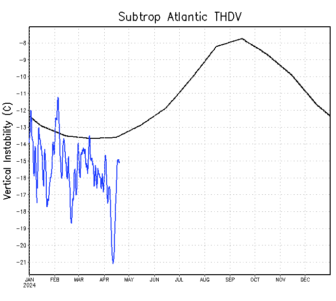
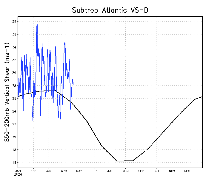
It's may so perhaps time to start watching some of the graphs.

Tropical Atlantic

Instability a lot higher than previous years, but still mostly below average.
Image

Shear running near or a little above average, hard to see any real trend here so far.
Image


Caribbean

Instability near to above normal.
Image

Shear seems to be above normal.
Image

Unfortunately the archives have not been updated for years so I can't find charts from last year for comparison.

source: http://www.ssd.noaa.gov/PS/TROP/TCFP/atlantic.html
0 likes   
M a r k
- - - - -
Join us in chat: Storm2K Chatroom Invite. Android and IOS apps also available.

The posts in this forum are NOT official forecasts and should not be used as such. Posts are NOT endorsed by any professional institution or STORM2K.org. For official information and forecasts, please refer to NHC and NWS products.

User avatar
weathaguyry
Category 5
Category 5
Posts: 1272
Age: 22
Joined: Wed Jun 15, 2016 5:16 am
Location: Long Island, NY

Re: 2017 indicators: SST's / MSLP / SAL / Steering / Instability

#210 Postby weathaguyry » Wed May 03, 2017 8:38 am

Image

Image

The sub-tropics don't look as good as prior years, possibly signaling more activity towards the tropics and less "slop storms" in the sub-tropics
0 likes   
My posts are only my opinions and NOT official forecasts. For official forecasts, consult the National Hurricane Center or the National Weather Service.

Irene 11', Sandy 12', Fay 20’, Isaias 20’, Elsa 21’, Henri 21’, Ida 21’

User avatar
tarheelprogrammer
S2K Supporter
S2K Supporter
Posts: 1793
Joined: Mon Mar 28, 2016 9:25 pm
Location: Raleigh, NC area (Garner, NC)

Re: 2017 indicators: SST's / MSLP / SAL / Steering / Instability

#211 Postby tarheelprogrammer » Wed May 03, 2017 3:13 pm

When do tropical waves start coming off the coast of Africa, and head toward the Caribbean?
0 likes   
My posts are not official forecasts. They are just my opinion and may or may not be backed by sound meteorological data. They are NOT endorsed by any professional institution or storm2k.org. For official information, please refer to the NHC and NWS products.

User avatar
Kazmit
Category 5
Category 5
Posts: 2124
Age: 22
Joined: Mon Jul 25, 2016 8:49 am
Location: Williamsburg, VA / Bermuda

Re: 2017 indicators: SST's / MSLP / SAL / Steering / Instability

#212 Postby Kazmit » Wed May 03, 2017 3:27 pm

tarheelprogrammer wrote:When do tropical waves start coming off the coast of Africa, and head toward the Caribbean?

Anytime from now really, however tropical waves off of Africa really start ramping up in June, and July is the peak. Here's a useful source: http://severe.worldweather.wmo.int/TCFW/RAIV_Workshop2016/04_TropicalWaves_JohnCangialosi.pdf
1 likes   
Igor 2010, Sandy 2012, Fay 2014, Gonzalo 2014, Joaquin 2015, Nicole 2016, Humberto 2019

I am only a tropical weather enthusiast. My predictions are not official and may or may not be backed by sound meteorological data. For official information, please refer to the NHC and NWS products.

User avatar
Hammy
Category 5
Category 5
Posts: 5849
Age: 41
Joined: Fri May 25, 2012 5:25 pm
Contact:

Re: 2017 indicators: SST's / MSLP / SAL / Steering / Instability

#213 Postby Hammy » Wed May 03, 2017 3:40 pm

Not that I'm expecting 2013 repeat suddenly, but the pattern seems to have been fairly consistent since February, with strong cold outbreaks still coming down with the weather systems tracking farther south. I know 2013 was a result of the thermohaline circulation weakening, and causing the spring pattern to continue the rest of the year--is there some way to check the circulation and salinity compared to normal, or is that not usually known in real time?
1 likes   
The above post is not official and should not be used as such. It is the opinion of the poster and may or may not be backed by sound meteorological data. It is not endorsed by any professional institution or storm2k.org. For official information, please refer to the NHC and NWS products.

User avatar
weathaguyry
Category 5
Category 5
Posts: 1272
Age: 22
Joined: Wed Jun 15, 2016 5:16 am
Location: Long Island, NY

Re: 2017 indicators: SST's / MSLP / SAL / Steering / Instability

#214 Postby weathaguyry » Wed May 03, 2017 4:04 pm

Hammy wrote:Not that I'm expecting 2013 repeat suddenly, but the pattern seems to have been fairly consistent since February, with strong cold outbreaks still coming down with the weather systems tracking farther south. I know 2013 was a result of the thermohaline circulation weakening, and causing the spring pattern to continue the rest of the year--is there some way to check the circulation and salinity compared to normal, or is that not usually known in real time?


As of now, the reason the cold outbreaks are coming down is because of a big ridge over Norhern Canada that may stay for a while, the GFS shows some hints of the ridge weakening and shifting east towards the middle of the month, allowing more warmer air to flood the atmosphere, but we shall see
0 likes   
My posts are only my opinions and NOT official forecasts. For official forecasts, consult the National Hurricane Center or the National Weather Service.

Irene 11', Sandy 12', Fay 20’, Isaias 20’, Elsa 21’, Henri 21’, Ida 21’

TheStormExpert

Re: 2017 indicators: SST's / MSLP / SAL / Steering / Instability

#215 Postby TheStormExpert » Wed May 03, 2017 4:19 pm

weathaguyry wrote:
Hammy wrote:Not that I'm expecting 2013 repeat suddenly, but the pattern seems to have been fairly consistent since February, with strong cold outbreaks still coming down with the weather systems tracking farther south. I know 2013 was a result of the thermohaline circulation weakening, and causing the spring pattern to continue the rest of the year--is there some way to check the circulation and salinity compared to normal, or is that not usually known in real time?


As of now, the reason the cold outbreaks are coming down is because of a big ridge over Norhern Canada that may stay for a while, the GFS shows some hints of the ridge weakening and shifting east towards the middle of the month, allowing more warmer air to flood the atmosphere, but we shall see

There's also this, something we haven't seen in quite awhile. :darrow:

Image

Image

Image
0 likes   

WeatherEmperor
S2K Supporter
S2K Supporter
Posts: 4806
Age: 41
Joined: Thu Sep 04, 2003 2:54 pm
Location: South Florida

Re: 2017 indicators: SST's / MSLP / SAL / Steering / Instability

#216 Postby WeatherEmperor » Wed May 03, 2017 4:32 pm

If the NAO has been mostly positive this winter/spring how come the east coast trough has been so strong? This contrasts to last year which had stronger ridging by the east coast


Sent from my iPhone 7 using Tapatalk
0 likes   

TheStormExpert

Re: 2017 indicators: SST's / MSLP / SAL / Steering / Instability

#217 Postby TheStormExpert » Wed May 03, 2017 4:36 pm

WeatherEmperor wrote:If the NAO has been mostly positive this winter/spring how come the east coast trough has been so strong? This contrasts to last year which had stronger ridging by the east coast


Sent from my iPhone 7 using Tapatalk

The East Coast trough hasn't been that strong up till the past week or so. Only the Northeast U.S. experienced a colder than normal winter.
0 likes   

User avatar
tarheelprogrammer
S2K Supporter
S2K Supporter
Posts: 1793
Joined: Mon Mar 28, 2016 9:25 pm
Location: Raleigh, NC area (Garner, NC)

Re: 2017 indicators: SST's / MSLP / SAL / Steering / Instability

#218 Postby tarheelprogrammer » Wed May 03, 2017 4:39 pm

Kazmit_ wrote:
tarheelprogrammer wrote:When do tropical waves start coming off the coast of Africa, and head toward the Caribbean?

Anytime from now really, however tropical waves off of Africa really start ramping up in June, and July is the peak. Here's a useful source: http://severe.worldweather.wmo.int/TCFW/RAIV_Workshop2016/04_TropicalWaves_JohnCangialosi.pdf


Thank you for the information. Have a great day :)
1 likes   
My posts are not official forecasts. They are just my opinion and may or may not be backed by sound meteorological data. They are NOT endorsed by any professional institution or storm2k.org. For official information, please refer to the NHC and NWS products.

User avatar
weathaguyry
Category 5
Category 5
Posts: 1272
Age: 22
Joined: Wed Jun 15, 2016 5:16 am
Location: Long Island, NY

Re: 2017 indicators: SST's / MSLP / SAL / Steering / Instability

#219 Postby weathaguyry » Wed May 03, 2017 5:04 pm

TheStormExpert wrote:
WeatherEmperor wrote:If the NAO has been mostly positive this winter/spring how come the east coast trough has been so strong? This contrasts to last year which had stronger ridging by the east coast


Sent from my iPhone 7 using Tapatalk

The East Coast trough hasn't been that strong up till the past week or so. Only the Northeast U.S. experienced a colder than normal winter.


It was much more evident especially in March, when everyone else was basking in early spring warmth, and I was shivering in 16 degree nighttime lows on Long Island.
0 likes   
My posts are only my opinions and NOT official forecasts. For official forecasts, consult the National Hurricane Center or the National Weather Service.

Irene 11', Sandy 12', Fay 20’, Isaias 20’, Elsa 21’, Henri 21’, Ida 21’

User avatar
NDG
S2K Supporter
S2K Supporter
Posts: 15446
Joined: Sun Jul 09, 2006 10:14 pm
Location: Orlando, FL

Re: 2017 indicators: SST's / MSLP / SAL / Steering / Instability

#220 Postby NDG » Wed May 03, 2017 6:35 pm

WeatherEmperor wrote:If the NAO has been mostly positive this winter/spring how come the east coast trough has been so strong? This contrasts to last year which had stronger ridging by the east coast


Sent from my iPhone 7 using Tapatalk


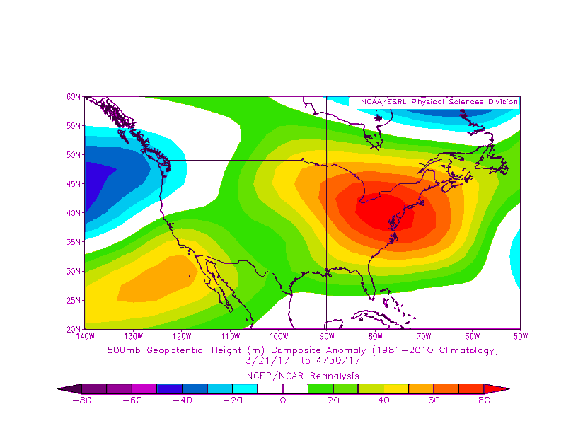
Mostly positive PNA during the past 8 weeks will cause deep troughs across the NE US from time to time.

Edit: To many's surpre, the overall pattern since the start of Spring is of higher heights across the NE US.

Image
0 likes   


Return to “Talkin' Tropics”

Who is online

Users browsing this forum: Brent, Google Adsense [Bot], USTropics and 39 guests