Texas Spring 2017
Moderator: S2k Moderators
Forum rules

The posts in this forum are NOT official forecast and should not be used as such. They are just the opinion of the poster and may or may not be backed by sound meteorological data. They are NOT endorsed by any professional institution or STORM2K.
-
bubba hotep

- S2K Supporter

- Posts: 6014
- Joined: Wed Dec 28, 2016 1:00 am
- Location: Collin County Texas
Re: Texas Spring 2017
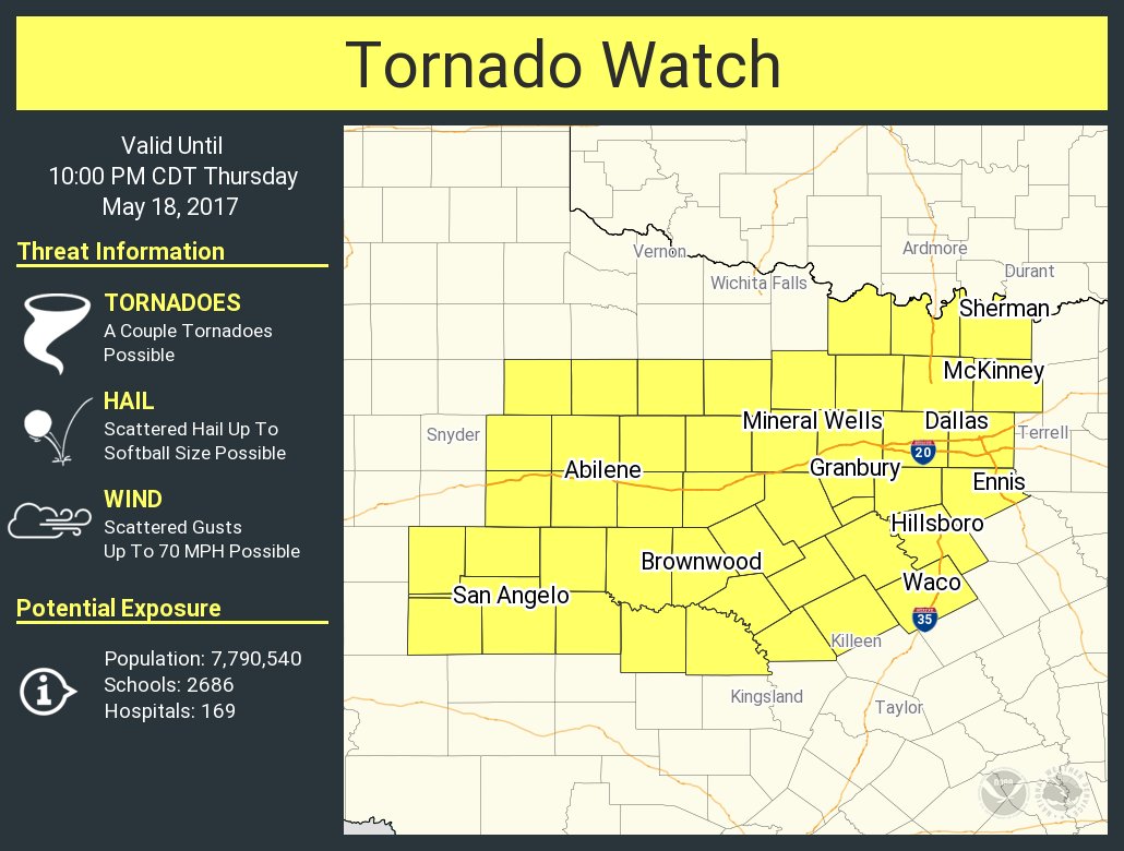
I'm actually a bit surprised that they have the initial watch this far east covering most of DFW. Hopefully, we don't see any tornadoes in the metroplex this afternoon.
0 likes
Winter time post are almost exclusively focused on the DFW area.
-
South Texas Storms

- Professional-Met

- Posts: 4259
- Joined: Thu Jun 24, 2010 12:28 am
- Location: Houston, TX
Re: Texas Spring 2017
Portastorm wrote:Meanwhile, further south, those of us in south central Texas are likely going to get screwed by the frickin' cap once again. This has been the story for the last 4-5 weeks (at least) where any measurable rainfall is squelched by the dreaded cap. Ugh.
And yeah, yeah, yeah ... don't tell me about the weekend forecast. I know it but I'll believe it when the rain actually falls.
#GrumpyPort
Yikes Porta...patience grasshopper
Euro and its ensemble has consistently indicated that much of SC TX will see about 2-3 inches of rain this weekend into early next week. I'm hopeful!
0 likes

Re: Texas Spring 2017
Still doesn't look like much rain will fall over the next week or so south of I-10 & along the coast. Maybe half an inch to an inch. We need a lot more rain than that around here. Will probably have to keep waiting.
0 likes


Re: Texas Spring 2017
So far cap has held in the FW forecasting area, Hrrr was too initiation happy. Most of the action in far NW TX
0 likes
The above post and any post by Ntxw is NOT an official forecast and should not be used as such. It is just the opinion of the poster and may or may not be backed by sound meteorological data. It is NOT endorsed by any professional institution including Storm2k. For official information, please refer to NWS products.
Help support Storm2K!
Re: Texas Spring 2017
Ntxw wrote:So far cap has held in the FW forecasting area, Hrrr was too initiation happy. Most of the action in far NW TX
Yep. Was thinking the same thing. Thought more storms would be brewing out west. We shall see. It is humid as heck outside with some cloud tops trying to climb. It better rain.
Last edited by gpsnowman on Thu May 18, 2017 3:44 pm, edited 1 time in total.
0 likes
-
CaptinCrunch

- S2K Supporter
- Posts: 8780
- Age: 58
- Joined: Mon Nov 03, 2003 4:33 pm
- Location: Kennedale, TX (Tarrant Co.)
Re: Texas Spring 2017
You know this is going to be a powerful system when you have a Tornado outbreak across the central Plains and Winter Storm warnings and watches for the Central Rockies of Colorado and Wyoming with 3"-8" of snowfall.
0 likes
-
bubba hotep
- S2K Supporter
- Posts: 6014
- Joined: Wed Dec 28, 2016 1:00 am
- Location: Collin County Texas
Re: Texas Spring 2017
Ntxw wrote:So far cap has held in the FW forecasting area, Hrrr was too initiation happy. Most of the action in far NW TX
More and more attempts out there, it looks like the cap is giving way. Should see some sustained updrafts here pretty soon.
0 likes
Winter time post are almost exclusively focused on the DFW area.
-
weatherdude1108
- Category 5

- Posts: 4228
- Joined: Tue Dec 13, 2011 1:04 pm
- Location: Northwest Austin/Cedar Park, TX
Re: Texas Spring 2017
I mean, I like the cap when it keeps potential hail and tornadoes at bay. We do need rain at the same time. Been watering my yard once a week. Looks green, but there are soil cracks in it that have widened. Surface soil not completely rock hard, still able to break it up with my hand, but definitely hard. I have compost sitting in the cracks, waiting for that multi-inch rain to bury it. 
I'm thinking we won't see any rain tonight or tomorrow (aside from light rain/drizzle). Hopefully this weekend's low severe threat with heavy rain/flooding potential with the slow-moving front will make up for it. Like Porta alluded to, I'm not holding my breath, and I'll believe it when I see it.

Bob Rose:
A more widespread coverage of rain showers and thunderstorms is forecast to occur across the region Saturday into Sunday when a weak cold front slowly sags southeast out of North Texas. Conditions appears favorable for the development of rain showers and scattered thunderstorms out ahead of the cold front beginning Saturday morning. Additional rain showers and thunderstorms look to continue Saturday night and Sunday behind the cold front. The threat for severe thunderstorms during this period will not be all that high. But due to the slow movement of the cold front and the presence of a very moist atmosphere, significant totals of rain will be possible Saturday into Sunday. Rainfall forecasts suggest widespread totals of 1-2 inches will be possible across the region, with isolated heavier totals. Do note that if the cold front moves slower than currently forecast, these totals could go higher. The rain is forecast to decrease in coverage across the Hill Country and Central Texas regions Sunday afternoon but continue across the coastal plains region. A 20-30 percent chance for mainly light rain showers is forecast Sunday night.
Another chance for rain and thunderstorms is forecast to develop Monday as a trough of low pressure moves east out of Mexico. This system is expected to quickly pull moisture north from the Gulf of Mexico, resulting in the development of rain showers and thunderstorms. The most favorable period for rain is expected to occur Monday night and Tuesday, with the rain tapering off Tuesday night. Rainfall from this system is forecast to generally average between 0.5 and 1 inch. This will be followed by sunny and dry weather next Wednesday through Friday.
http://www.lcra.org/water/river-and-wea ... ather.aspx
I'm thinking we won't see any rain tonight or tomorrow (aside from light rain/drizzle). Hopefully this weekend's low severe threat with heavy rain/flooding potential with the slow-moving front will make up for it. Like Porta alluded to, I'm not holding my breath, and I'll believe it when I see it.
Bob Rose:
A more widespread coverage of rain showers and thunderstorms is forecast to occur across the region Saturday into Sunday when a weak cold front slowly sags southeast out of North Texas. Conditions appears favorable for the development of rain showers and scattered thunderstorms out ahead of the cold front beginning Saturday morning. Additional rain showers and thunderstorms look to continue Saturday night and Sunday behind the cold front. The threat for severe thunderstorms during this period will not be all that high. But due to the slow movement of the cold front and the presence of a very moist atmosphere, significant totals of rain will be possible Saturday into Sunday. Rainfall forecasts suggest widespread totals of 1-2 inches will be possible across the region, with isolated heavier totals. Do note that if the cold front moves slower than currently forecast, these totals could go higher. The rain is forecast to decrease in coverage across the Hill Country and Central Texas regions Sunday afternoon but continue across the coastal plains region. A 20-30 percent chance for mainly light rain showers is forecast Sunday night.
Another chance for rain and thunderstorms is forecast to develop Monday as a trough of low pressure moves east out of Mexico. This system is expected to quickly pull moisture north from the Gulf of Mexico, resulting in the development of rain showers and thunderstorms. The most favorable period for rain is expected to occur Monday night and Tuesday, with the rain tapering off Tuesday night. Rainfall from this system is forecast to generally average between 0.5 and 1 inch. This will be followed by sunny and dry weather next Wednesday through Friday.
http://www.lcra.org/water/river-and-wea ... ather.aspx
0 likes
The preceding post is NOT an official forecast, and should not be used as such. It is only the opinion of the poster and may or may not be backed by sound meteorological data. It is NOT endorsed by any professional institution including storm2k.org. For Official Information please refer to the NHC and NWS products.
-
Brent
- S2K Supporter
- Posts: 38755
- Age: 37
- Joined: Sun May 16, 2004 10:30 pm
- Location: Tulsa Oklahoma
- Contact:
Re: Texas Spring 2017
gpsnowman wrote:Ntxw wrote:So far cap has held in the FW forecasting area, Hrrr was too initiation happy. Most of the action in far NW TX
Yep. Was thinking the same thing. Thought more storms would be brewing out west. We shall see. It is humid as heck outside with some cloud tops trying to climb. It better rain.
93/69 at DFW... 88/72 at McKinney. You're right, it better rain. It's positively disgusting out.
HRRR trying to skip around DFW this evening
Last edited by Brent on Thu May 18, 2017 4:18 pm, edited 1 time in total.
0 likes
#neversummer
-
starsfan65

- Category 2

- Posts: 738
- Age: 48
- Joined: Thu Dec 17, 2015 1:18 pm
- Location: Garland,Tx
-
South Texas Storms
- Professional-Met
- Posts: 4259
- Joined: Thu Jun 24, 2010 12:28 am
- Location: Houston, TX
Re: Texas Spring 2017
Cpv17 wrote:Still doesn't look like much rain will fall over the next week or so south of I-10 & along the coast. Maybe half an inch to an inch. We need a lot more rain than that around here. Will probably have to keep waiting.
Euro and Canadian say otherwise...1-3 inches across SE TX (even along the coast) this weekend into the first half of next week.
0 likes
Re: Texas Spring 2017
South Texas Storms wrote:Cpv17 wrote:Still doesn't look like much rain will fall over the next week or so south of I-10 & along the coast. Maybe half an inch to an inch. We need a lot more rain than that around here. Will probably have to keep waiting.
Euro and Canadian say otherwise...1-3 inches across SE TX (even along the coast) this weekend into the first half of next week.
I sure hope they're right. Been a good 5 or 6 weeks here without any measurable rainfall & with all these windy days the ground has definitely dried out.
0 likes
-
South Texas Storms
- Professional-Met
- Posts: 4259
- Joined: Thu Jun 24, 2010 12:28 am
- Location: Houston, TX
Re: Texas Spring 2017
So far the strongest and most widespread coverage of storms have remained across Oklahoma today. Latest models suggest much of the state could dodge a bullet from this disturbance. However, increasing rain chances can be expected across a large part of Texas over the next several days as a series of disturbances track across the region. I'm hopeful that much of the area will receive 1-3 inches of rain by the middle part of next week.

0 likes
-
TheProfessor

- Professional-Met
- Posts: 3506
- Age: 29
- Joined: Tue Dec 03, 2013 10:56 am
- Location: Wichita, Kansas
Re: Texas Spring 2017
Looks like those Cumulus clouds out west are beginning to grow.
0 likes
An alumnus of The Ohio State University.
Your local National Weather Service office is your best source for weather information.
Your local National Weather Service office is your best source for weather information.
Re: Texas Spring 2017
Ok, a few storms are forming out west albeit too far west for my liking. Will the cap erode with enough daylight left to bring DFW much needed rain? Summer nastiness is near, gosh darn it dang blabbit nabbit it is near.
0 likes
-
bubba hotep
- S2K Supporter
- Posts: 6014
- Joined: Wed Dec 28, 2016 1:00 am
- Location: Collin County Texas
Re: Texas Spring 2017
This cell didn't waste any time going from struggling updraft to svr warned

0 likes
Winter time post are almost exclusively focused on the DFW area.

Re: Texas Spring 2017
Portastorm wrote:Meanwhile, further south, those of us in south central Texas are likely going to get screwed by the frickin' cap once again. This has been the story for the last 4-5 weeks (at least) where any measurable rainfall is squelched by the dreaded cap. Ugh.
And yeah, yeah, yeah ... don't tell me about the weekend forecast. I know it but I'll believe it when the rain actually falls.
#GrumpyPort
I agree and unfortunately despite the possible 1-2 inch with some isolated higher totals projected for this weekend by the NWS, short range NAM, WRF and RGEM continue to indicate spotty coverage at best. Given that they have performed well this month, there's little reason to doubt them at this time. Then there is the persistent strong cap to contend with which EXW's afternoon discussion makes a point to highlight. Also frontal boundaries can be real tricky to forecast as we saw what happened last month where high amounts of rain were forecasted for the Austin area but the front ended up stalling 70 miles to the north flooding the Killeen-Temple area while dropping very little rain here. At this point unless we see some sort of heavy rain event around Memorial day weekend, May will follow in April's footsteps with well below average rainfall.
I need to find a way to defeat my arch enemy, the Dry Miser...
0 likes
Resident Rain Miser
I am a weather hobbyist living 3.5 miles south of Downtown Austin and in no way or fashion should anything I say concerning forecasts be taken seriously. Please check your local NWS for accurate weather forecasting and conditions.
I am a weather hobbyist living 3.5 miles south of Downtown Austin and in no way or fashion should anything I say concerning forecasts be taken seriously. Please check your local NWS for accurate weather forecasting and conditions.
-
Yukon Cornelius
- S2K Supporter
- Posts: 1842
- Age: 42
- Joined: Thu Dec 20, 2012 9:23 pm
- Location: Dean, TX/Westcliffe, CO
Re: Texas Spring 2017
Unless something changes, or something else builds, it looks like everything appears to stay west.
0 likes
#neversummer
-
bubba hotep
- S2K Supporter
- Posts: 6014
- Joined: Wed Dec 28, 2016 1:00 am
- Location: Collin County Texas
Re: Texas Spring 2017
Tor warning now on that cell out west of DFW
0 likes
Winter time post are almost exclusively focused on the DFW area.
-
TheProfessor
- Professional-Met
- Posts: 3506
- Age: 29
- Joined: Tue Dec 03, 2013 10:56 am
- Location: Wichita, Kansas
Re: Texas Spring 2017
bubba hotep wrote:Tor warning now on that cell out west of DFW
We'll have to see if it takes a right turn like some of the storms up north are.
0 likes
An alumnus of The Ohio State University.
Your local National Weather Service office is your best source for weather information.
Your local National Weather Service office is your best source for weather information.
Return to “USA & Caribbean Weather”
Who is online
Users browsing this forum: No registered users and 142 guests