Texas Summer 2017

U.S. & Caribbean Weather Discussions and Severe Weather Events

Moderator: S2k Moderators

Forum rules

The posts in this forum are NOT official forecast and should not be used as such. They are just the opinion of the poster and may or may not be backed by sound meteorological data. They are NOT endorsed by any professional institution or STORM2K.

Help Support Storm2K
Message
Author
User avatar
bubba hotep
S2K Supporter
S2K Supporter
Posts: 5837
Joined: Wed Dec 28, 2016 1:00 am
Location: Collin County Texas

Re: Texas Summer 2017

#141 Postby bubba hotep » Mon Jun 12, 2017 11:06 pm

Ntxw wrote:Looks like the dull typical summer weather kicks in this week. Mid 90s and lows in 70s, turning up the gear..will have to see if a trough can clip but its getting harder for fronts to make it. Withholding any ideas on the gulf, as we seldom see relief from that way past several years so we'll see what happens there. I'd like to see something stream up from the EPAC rather

Did I mention summer is the worst season ever? Winter can't be here soon enough :lol:


It's practically July and then before we know it August. Summer is basically over with :lol:
2 likes   
Winter time post are almost exclusively focused on the DFW area.

User avatar
JDawg512
Category 5
Category 5
Posts: 1075
Age: 45
Joined: Mon Aug 26, 2013 8:56 pm
Location: Austin
Contact:

Re: Texas Summer 2017

#142 Postby JDawg512 » Tue Jun 13, 2017 2:02 am

I'd like to believe that this summer will be average to above average for rain, though it's not starting off well. As I've said before it's much better to have rainfall spread out over a longer period of time as opposed to high amounts in a short period. We could see a very wet 3-4 week period but if it's bone dry the rest of the summer, whatever rainfall that occures will only have a short time to affect soil moisture and vegetation greenery.

I agree with Ntxw about wanting to see an active eastern Pacific since the gulf can be a gamble when it comes to the movement of tropical systems.
0 likes   
Resident Rain Miser

I am a weather hobbyist living 3.5 miles south of Downtown Austin and in no way or fashion should anything I say concerning forecasts be taken seriously. Please check your local NWS for accurate weather forecasting and conditions.

Yukon Cornelius
S2K Supporter
S2K Supporter
Posts: 1798
Age: 41
Joined: Thu Dec 20, 2012 9:23 pm
Location: Dean, TX/Westcliffe, CO

Re: Texas Summer 2017

#143 Postby Yukon Cornelius » Tue Jun 13, 2017 7:43 am

I had my hopes on the decent at best rain chances mid week, only to check out the forecast this morning to see its all been taken out and replaced with hot and breezy conditions. I guess summer is indeed here. sigh
0 likes   
#neversummer

User avatar
Ntxw
Storm2k Moderator
Storm2k Moderator
Posts: 22783
Joined: Wed Oct 21, 2009 6:34 pm
Location: DFW, Texas

Re: Texas Summer 2017

#144 Postby Ntxw » Tue Jun 13, 2017 8:50 am

In other news we continue to march into the solar minimum. At 42 days this year or roughly 1/4th of the year so far has been blank. Percentage wise the sun hasn't been as blank since 2009 during the last solar min.
Daily Sun: 13 Jun 17
The sun is blank--no sunspots. Credit: SDO/HMI

Sunspot number: 0
What is the sunspot number?
Updated 13 Jun 2017

Spotless Days
Current Stretch: 4 days
2017 total: 42 days (25%)
2016 total: 32 days (9%)
2015 total: 0 days (0%)
2014 total: 1 day (<1%)
2013 total: 0 days (0%)
2012 total: 0 days (0%)
2011 total: 2 days (<1%)
2010 total: 51 days (14%)
2009 total: 260 days (71%)
0 likes   
The above post and any post by Ntxw is NOT an official forecast and should not be used as such. It is just the opinion of the poster and may or may not be backed by sound meteorological data. It is NOT endorsed by any professional institution including Storm2k. For official information, please refer to NWS products.

  Help support Storm2K!
Help Support Storm2K

User avatar
Portastorm
Storm2k Moderator
Storm2k Moderator
Posts: 9914
Age: 63
Joined: Fri Jul 11, 2003 9:16 am
Location: Round Rock, TX
Contact:

Re: Texas Summer 2017

#145 Postby Portastorm » Tue Jun 13, 2017 9:15 am

JDawg512 wrote:I'd like to believe that this summer will be average to above average for rain, though it's not starting off well. As I've said before it's much better to have rainfall spread out over a longer period of time as opposed to high amounts in a short period. We could see a very wet 3-4 week period but if it's bone dry the rest of the summer, whatever rainfall that occures will only have a short time to affect soil moisture and vegetation greenery.

I agree with Ntxw about wanting to see an active eastern Pacific since the gulf can be a gamble when it comes to the movement of tropical systems.


Yeah, I'll hop on board as well about Ntxw's comments ... south central Texas gets much more tropical action and rains out of the eastern Pacific than we do the Gulf. An inverted trough or TUTT low may, from time to time, move inland from the Gulf and give us rain chances but it's not all that often.
0 likes   
Any forecasts under my name are to be taken with a grain of salt. Get your best forecasts from the National Weather Service and National Hurricane Center.

User avatar
hriverajr
Professional-Met
Professional-Met
Posts: 786
Joined: Tue Jul 19, 2005 12:16 am

Re: Texas Summer 2017

#146 Postby hriverajr » Tue Jun 13, 2017 9:57 am

Of course as a general rule.. Eastern Pacific Systems normally don't affect us in the heart of summer unfortunately. So yea... stuck mostly with the gulf now.
1 likes   
Anything I post is my personal opinion and should not used for any type of planning or lifesaving reasons. Please refer to National Weather Service forecasts.

User avatar
JDawg512
Category 5
Category 5
Posts: 1075
Age: 45
Joined: Mon Aug 26, 2013 8:56 pm
Location: Austin
Contact:

Re: Texas Summer 2017

#147 Postby JDawg512 » Tue Jun 13, 2017 2:29 pm

And it remains to be seen how active the eastern Pacific gets later this year. Water temps aren't as warm as they have been the last couple of years for obvious reasons. All in all the pattern we've been dealing with and will continue to deal with is La Niña-esq albeit weak influence. For that reason alone, I'm having to keep my rain optimism down until something significant shows up in the mid range models that would warrant excitement.
0 likes   
Resident Rain Miser

I am a weather hobbyist living 3.5 miles south of Downtown Austin and in no way or fashion should anything I say concerning forecasts be taken seriously. Please check your local NWS for accurate weather forecasting and conditions.

User avatar
Portastorm
Storm2k Moderator
Storm2k Moderator
Posts: 9914
Age: 63
Joined: Fri Jul 11, 2003 9:16 am
Location: Round Rock, TX
Contact:

Re: Texas Summer 2017

#148 Postby Portastorm » Tue Jun 13, 2017 2:51 pm

:uarrow:

JDawg, perhaps we will get lucky and that potential WCARIB large low will develop and move into the WGOM and sling lots of moisture up this way for diurnal showers/storms.
1 likes   
Any forecasts under my name are to be taken with a grain of salt. Get your best forecasts from the National Weather Service and National Hurricane Center.

weatherdude1108
Category 5
Category 5
Posts: 4228
Joined: Tue Dec 13, 2011 1:04 pm
Location: Northwest Austin/Cedar Park, TX

Re: Texas Summer 2017

#149 Postby weatherdude1108 » Tue Jun 13, 2017 2:54 pm

Meanwhile, gunna have to run my sprinklers this weekend. Let the hibernation begin.
:grr: :cry: :roll:

000
FXUS64 KEWX 131942
AFDEWX

Area Forecast Discussion
National Weather Service Austin/San Antonio TX
242 PM CDT Tue Jun 13 2017

.SHORT TERM (Tonight through Wednesday Night)...

Weather headlines this period focus on the scattered to isolated
showers ongoing this afternoon and the increasing temperatures as
heat index values rise tomorrow as they reach into the 100-105F
range.

Slightly deeper moisture has infiltrated the coastal plains this
afternoon with average PWATs near 1.4-1.5" near HWY 77 with areas
along and west of I-35 in the 1.1.-1.2" range. Where the greater and
deeper moisture exist coincident with nearly 1500 J/Kg of SBCAPE,
scattered to isolated showers are being generated. The showers have
struggled to even produce lightning given the poor lapse rates. This
activity will struggle to reach the I-35 corridor through the late
afternoon. All activity will dissipate quickly near to just after
sunset.
Across far west Texas and the Big Bend area, thunderstorms
are expected to develop on a dryline and shift towards the southern
Edwards Plateau and portions of the Rio Grande Plains but will likely
fall apart prior to reaching the area late tonight.


Overnight and into Wednesday, low clouds will once again build over
the region and some patchy ground fog will also be possible across
the Escarpment region and coastal plains. Fog is not expected to be
dense. There could be a small chance of very light or patchy drizzle
with the low clouds in the morning but impact and coverage will be
low and left out of the official forecast. Stronger mid- and low-
level ridging will occur tomorrow and coupled with a stronger capping
inversion - this will act to limit shower coverage
with only very
isolated activity across the coastal plains.

&&

.LONG TERM (Thursday through Tuesday)...

Main story of the long term will be the above normal temperatures
and persistent 100-105F heat indices each afternoon. Medium and long
range models have backed off on rain chances and most the this
period appears dry with very limited rain chances.


Overall synoptic pattern heading into late week features a
strengthening low-level H85-H7 sub-tropical Atlantic ridging
underneath a H5 ridge centered over north Mexico.
The low-level
southeast flow off the Gulf will keep morning temperatures warm with
clouds with a gradual mix out to partly cloudy to nearly clear skies
by the afternoons.
Given the ridging in place and warming H925/85
temperatures, surface temperatures will climb into the mid to upper
90s
with even a few spot 100s in the Rio Grande Plains. With the
expected humidity levels late week, heat index values reaching
100-105F across the entire region are expected.
This is below heat
advisory criteria (108F) at this time but will continue to monitor
for potentially warmer conditions. Models point to a small
thunderstorm complex being possible well north of the region late
Thursday into early Friday as the upper level ridge begins to shift
west. Any risk of this complex reaching south-central Texas appears
very low.


A slight pattern change occurs going into the weekend as stronger
northwest and even north flow occurs in the H5-H3 levels but the low
level ridging continues to hold on.
Slightly below normal PWATs,
low-level ridging, and a capping inversion should keep shower
coverage at bay through the weekend. Temperatures will again be quite
warm and above average.

By early next week, the mid- and upper-level ridge axis attempts to
re-establish itself over north Texas. This pattern will place south-
central Texas in deeper easterly flow as weak inverted trough occurs
over the southern Gulf of Mexico. The strength of the ridge has
increased over the past few model runs and would likely persist the
dry and hot conditions over the region
with only very limited sea-
breeze activity early next week.
0 likes   
The preceding post is NOT an official forecast, and should not be used as such. It is only the opinion of the poster and may or may not be backed by sound meteorological data. It is NOT endorsed by any professional institution including storm2k.org. For Official Information please refer to the NHC and NWS products.

Brent
S2K Supporter
S2K Supporter
Posts: 38087
Age: 36
Joined: Sun May 16, 2004 10:30 pm
Location: Tulsa Oklahoma
Contact:

Re: Texas Summer 2017

#150 Postby Brent » Tue Jun 13, 2017 4:07 pm

I've been in New York City since Friday and we're having a heat wave rivaling Texas heat. Actually Newark hit 99 today. It's pretty awful lol

Edit just reported LaGuardia hit 101. LaGuardia hit 100 before Dallas did? :roflmao:

and not everywhere up here has A/C.

and my neck is sunburnt just from being out in the city all day.

Of course I leave tomorrow night and it cools off. :lol:
Last edited by Brent on Tue Jun 13, 2017 4:19 pm, edited 1 time in total.
0 likes   
#neversummer

weatherdude1108
Category 5
Category 5
Posts: 4228
Joined: Tue Dec 13, 2011 1:04 pm
Location: Northwest Austin/Cedar Park, TX

Re: Texas Summer 2017

#151 Postby weatherdude1108 » Tue Jun 13, 2017 4:17 pm

Brent wrote:I've been in New York City since Friday and we're having a heat wave rivaling Texas heat. Actually Newark hit 99 today. It's pretty awful lol

and not everywhere up here has A/C.

Of course I leave tomorrow night and it cools off. :lol:


Haha! Of course. Always happens that way. At least you won't go into "heat shock" when you come back. You're already used to it, and this is a "dry" heat. :lol:
0 likes   
The preceding post is NOT an official forecast, and should not be used as such. It is only the opinion of the poster and may or may not be backed by sound meteorological data. It is NOT endorsed by any professional institution including storm2k.org. For Official Information please refer to the NHC and NWS products.

gpsnowman
S2K Supporter
S2K Supporter
Posts: 3185
Joined: Fri Jan 07, 2011 10:35 am
Location: Grand Prairie Tx

Re: Texas Summer 2017

#152 Postby gpsnowman » Tue Jun 13, 2017 6:17 pm

Looks like the death throes of summer are about to hit. Slowly creeping temps getting near 100 degrees with our favorite friend humidity buddying up as well towards the weekend. Why oh why do we have to have this time of year. Three solid months of this weather nonsense. I hate to use the word hate, but I hate this time of year. Just hate it till I can hate no more. Late September cool front, you are my only hope. :grrr: :( :froze:
1 likes   

Brent
S2K Supporter
S2K Supporter
Posts: 38087
Age: 36
Joined: Sun May 16, 2004 10:30 pm
Location: Tulsa Oklahoma
Contact:

Re: Texas Summer 2017

#153 Postby Brent » Tue Jun 13, 2017 8:52 pm

gpsnowman wrote:Looks like the death throes of summer are about to hit. Slowly creeping temps getting near 100 degrees with our favorite friend humidity buddying up as well towards the weekend. Why oh why do we have to have this time of year. Three solid months of this weather nonsense. I hate to use the word hate, but I hate this time of year. Just hate it till I can hate no more. Late September cool front, you are my only hope. :grrr: :( :froze:


well only about 2 weeks til the days start getting shorter again... :P

One thing about heat waves up here... they rarely last more than 4-5 days. Don't we wish that was true in Texas? lol
0 likes   
#neversummer

User avatar
South Texas Storms
Professional-Met
Professional-Met
Posts: 4224
Joined: Thu Jun 24, 2010 12:28 am
Location: Houston, TX

Re: Texas Summer 2017

#154 Postby South Texas Storms » Tue Jun 13, 2017 8:54 pm

Portastorm wrote::uarrow:

JDawg, perhaps we will get lucky and that potential WCARIB large low will develop and move into the WGOM and sling lots of moisture up this way for diurnal showers/storms.


Yeah I think that's a legitimate possibility for us next week. That's pretty much our only hope right now too. Really hope it happens.
0 likes   

User avatar
bubba hotep
S2K Supporter
S2K Supporter
Posts: 5837
Joined: Wed Dec 28, 2016 1:00 am
Location: Collin County Texas

Re: Texas Summer 2017

#155 Postby bubba hotep » Tue Jun 13, 2017 9:35 pm

Ntxw wrote:In other news we continue to march into the solar minimum. At 42 days this year or roughly 1/4th of the year so far has been blank. Percentage wise the sun hasn't been as blank since 2009 during the last solar min.
Daily Sun: 13 Jun 17
The sun is blank--no sunspots. Credit: SDO/HMI

Sunspot number: 0
What is the sunspot number?
Updated 13 Jun 2017

Spotless Days
Current Stretch: 4 days
2017 total: 42 days (25%)
2016 total: 32 days (9%)
2015 total: 0 days (0%)
2014 total: 1 day (<1%)
2013 total: 0 days (0%)
2012 total: 0 days (0%)
2011 total: 2 days (<1%)
2010 total: 51 days (14%)
2009 total: 260 days (71%)


There it is again. Also, big west based QBO flipped east that summer. Other analogs based only on QBO, '14 and '83 - both were strong west based in January and flipped east during the summer.
1 likes   
Winter time post are almost exclusively focused on the DFW area.

User avatar
bubba hotep
S2K Supporter
S2K Supporter
Posts: 5837
Joined: Wed Dec 28, 2016 1:00 am
Location: Collin County Texas

Re: Texas Summer 2017

#156 Postby bubba hotep » Tue Jun 13, 2017 9:49 pm

bubba hotep wrote:
Ntxw wrote:In other news we continue to march into the solar minimum. At 42 days this year or roughly 1/4th of the year so far has been blank. Percentage wise the sun hasn't been as blank since 2009 during the last solar min.
Daily Sun: 13 Jun 17
The sun is blank--no sunspots. Credit: SDO/HMI

Sunspot number: 0
What is the sunspot number?
Updated 13 Jun 2017

Spotless Days
Current Stretch: 4 days
2017 total: 42 days (25%)
2016 total: 32 days (9%)
2015 total: 0 days (0%)
2014 total: 1 day (<1%)
2013 total: 0 days (0%)
2012 total: 0 days (0%)
2011 total: 2 days (<1%)
2010 total: 51 days (14%)
2009 total: 260 days (71%)


There it is again. Also, big west based QBO flipped east that summer. Other analogs based only on QBO, '14 and '83 - both were strong west based in January and flipped east during the summer.


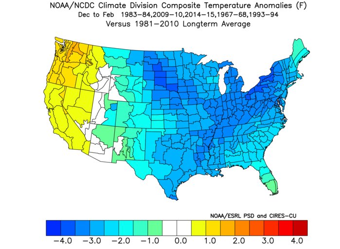
Here is the Top 5 January West based QBO yrs that saw a flip during the summer

Image
2 likes   
Winter time post are almost exclusively focused on the DFW area.

User avatar
South Texas Storms
Professional-Met
Professional-Met
Posts: 4224
Joined: Thu Jun 24, 2010 12:28 am
Location: Houston, TX

Re: Texas Summer 2017

#157 Postby South Texas Storms » Wed Jun 14, 2017 3:19 am

0z Euro shows a TS hitting TX next week dumping a lot of rain for areas along and east of IH-35.
1 likes   

User avatar
Ntxw
Storm2k Moderator
Storm2k Moderator
Posts: 22783
Joined: Wed Oct 21, 2009 6:34 pm
Location: DFW, Texas

Re: Texas Summer 2017

#158 Postby Ntxw » Wed Jun 14, 2017 6:57 am

Euro solution would make things a bit interesting and definitely needed rain from the system. Maybe a tad more west would be ideal but still way out on something yet to form. Surge of moisture at least from the BOC. Between it and the western ridge I hope the system wins for us!
1 likes   
The above post and any post by Ntxw is NOT an official forecast and should not be used as such. It is just the opinion of the poster and may or may not be backed by sound meteorological data. It is NOT endorsed by any professional institution including Storm2k. For official information, please refer to NWS products.


  Help support Storm2K!

Help Support Storm2K


User avatar
bubba hotep
S2K Supporter
S2K Supporter
Posts: 5837
Joined: Wed Dec 28, 2016 1:00 am
Location: Collin County Texas

Re: Texas Summer 2017

#159 Postby bubba hotep » Wed Jun 14, 2017 7:42 am

South Texas Storms wrote:0z Euro shows a TS hitting TX next week dumping a lot of rain for areas along and east of IH-35.


Models have been struggling with the northern stream, multiple waves coming in with an active Pacific jet. The Euro has started trending back towards a deeper sharper through across the GL/OV, more of what it showed in the early runs that had the system going towards Florida.

ETA: Looks like the 00z Euro Op is an outlier with the EPS showing two favored clusters - one into eastern Louisiana over to the Florida Panhandle and the other info Mexico via BOC.
0 likes   
Winter time post are almost exclusively focused on the DFW area.

weatherdude1108
Category 5
Category 5
Posts: 4228
Joined: Tue Dec 13, 2011 1:04 pm
Location: Northwest Austin/Cedar Park, TX

Re: Texas Summer 2017

#160 Postby weatherdude1108 » Wed Jun 14, 2017 2:53 pm

000
FXUS64 KEWX 141938
AFDEWX

Area Forecast Discussion
National Weather Service Austin/San Antonio TX
238 PM CDT Wed Jun 14 2017

.SHORT TERM (Tonight through Thursday Night)...
Dry, hot/warm and humid weather conditions are expected through
Thursday night across South Central Texas. There will be a pattern of
increasing clouds in the evenings and overnight periods with clouds
scattering late mornings into the afternoons for partly cloudy skies.
Thursday`s high temperatures will be in the mid to upper 90s across
much of the area to 102 across parts of Dimmit county over the
southwest of the region. Heat index values will reach the 100 to 105
mark in the afternoon along and east of Interstate 35 with some spots
getting to the 106 to 108 range along the Rio Grande Plains.

&&

.LONG TERM (Friday through Wednesday)...
Dry, hot and humid weather conditions continue through the middle of
next week as an upper level high pressure ridging dominates the
region. Heat indices are likely to reach the 100 to 106 on Friday
afternoon along and east of Interstate 35. Few spots could reach the
108 mark for an hour or two across Karnes, Gonzales and Dewitt
counties and southwest part of the Rio Grande Plains. If you plan to
do outdoor activities any of the upcoming afternoons, make sure to
drink plenty of water and look for shaded areas.

A weak frontal boundary is forecast to move east of the area late
Monday into Tuesday morning. Chances for rain are very limited across
the area as mid to upper levels look very dry per GFS forecast
soundings.

Will be monitoring closely the Gulf of Mexico for late next week as a
tropical disturbance may develop and brings rain chances to the area.

0 likes   
The preceding post is NOT an official forecast, and should not be used as such. It is only the opinion of the poster and may or may not be backed by sound meteorological data. It is NOT endorsed by any professional institution including storm2k.org. For Official Information please refer to the NHC and NWS products.


Return to “USA & Caribbean Weather”

Who is online

Users browsing this forum: No registered users and 13 guests