ATL: CINDY - Post-Tropical - Discussion
Moderator: S2k Moderators
-
Ivanhater

- Storm2k Moderator

- Posts: 11221
- Age: 39
- Joined: Fri Jul 01, 2005 8:25 am
- Location: Pensacola
Re: ATL: INVEST 93L - Discussion
Yes, Euro totally missed this a few days ago and having the low move into the BOC.
1 likes
Michael
-
cycloneye

- Admin

- Posts: 149472
- Age: 69
- Joined: Thu Oct 10, 2002 10:54 am
- Location: San Juan, Puerto Rico
Re: ATL: INVEST 93L - Discussion
2 likes
Visit the Caribbean-Central America Weather Thread where you can find at first post web cams,radars
and observations from Caribbean basin members Click Here
and observations from Caribbean basin members Click Here
Re: ATL: INVEST 93L - Discussion
0 likes
-
Aric Dunn
- Category 5

- Posts: 21238
- Age: 43
- Joined: Sun Sep 19, 2004 9:58 pm
- Location: Ready for the Chase.
- Contact:
Re: ATL: INVEST 93L - Discussion
There is some serious convergence right here as the wave axis sharpens on the NE side. . should see a large convective burst.

1 likes
Note: If I make a post that is brief. Please refer back to previous posts for the analysis or reasoning. I do not re-write/qoute what my initial post said each time.
If there is nothing before... then just ask
Space & Atmospheric Physicist, Embry-Riddle Aeronautical University,
I believe the sky is falling...
If there is nothing before... then just ask
Space & Atmospheric Physicist, Embry-Riddle Aeronautical University,
I believe the sky is falling...
-
tarheelprogrammer

- S2K Supporter

- Posts: 1793
- Joined: Mon Mar 28, 2016 9:25 pm
- Location: Raleigh, NC area (Garner, NC)
Re: ATL: INVEST 93L - Discussion
It does look to be getting a ton more organized in such a short span. Still think the center is east of where the NHC and others have it. Aric is close to my thinking just a tad east. Just an opinion though. You can see the clouds all around the system are starting to rotate around it more. It is a race between 92L and 93L to be Bret. 
0 likes
My posts are not official forecasts. They are just my opinion and may or may not be backed by sound meteorological data. They are NOT endorsed by any professional institution or storm2k.org. For official information, please refer to the NHC and NWS products.
-
Aric Dunn
- Category 5
- Posts: 21238
- Age: 43
- Joined: Sun Sep 19, 2004 9:58 pm
- Location: Ready for the Chase.
- Contact:
Re: ATL: INVEST 93L - Discussion
tarheelprogrammer wrote:It does look to be getting a ton more organized in such a short span. Still think the center is east of where the NHC and others have it. Aric is close to my thinking just a tad east. Just an opinion though. You can see the clouds all around the system are starting to rotate around it more. It is a race between 92L and 93L to be Bret.
my circle is not where I think a LLC is going to form necessarily. I was just mentioning that there is a large amount of convergence in this area.
1 likes
Note: If I make a post that is brief. Please refer back to previous posts for the analysis or reasoning. I do not re-write/qoute what my initial post said each time.
If there is nothing before... then just ask
Space & Atmospheric Physicist, Embry-Riddle Aeronautical University,
I believe the sky is falling...
If there is nothing before... then just ask
Space & Atmospheric Physicist, Embry-Riddle Aeronautical University,
I believe the sky is falling...
-
tarheelprogrammer
- S2K Supporter
- Posts: 1793
- Joined: Mon Mar 28, 2016 9:25 pm
- Location: Raleigh, NC area (Garner, NC)
Re: ATL: INVEST 93L - Discussion
Aric Dunn wrote:tarheelprogrammer wrote:It does look to be getting a ton more organized in such a short span. Still think the center is east of where the NHC and others have it. Aric is close to my thinking just a tad east. Just an opinion though. You can see the clouds all around the system are starting to rotate around it more. It is a race between 92L and 93L to be Bret.
my circle is not where I think a LLC is going to form necessarily. I was just mentioning that there is a large amount of convergence in this area.
Oops sorry. I took it the wrong way. Where do you think the LLC is or will be soon then?
0 likes
My posts are not official forecasts. They are just my opinion and may or may not be backed by sound meteorological data. They are NOT endorsed by any professional institution or storm2k.org. For official information, please refer to the NHC and NWS products.
-
Dean4Storms
- S2K Supporter
- Posts: 6358
- Age: 63
- Joined: Sun Aug 31, 2003 1:01 pm
- Location: Miramar Bch. FL
Re: ATL: INVEST 93L - Discussion
Hello everyone....looks like 2017 season is off and running!
Still looks very disorganized at the lower levels with apparent SSE winds all thru the MLC. Need another day or two and if that MLC continues to build convection it could develop a surface reflection but it will take time from this point.
Still looks very disorganized at the lower levels with apparent SSE winds all thru the MLC. Need another day or two and if that MLC continues to build convection it could develop a surface reflection but it will take time from this point.
2 likes
Re: ATL: INVEST 93L - Discussion
South Texas Storms wrote:It actually looks like the 12z NAM has a good handle on how things are progressing so far this afternoon.
And the end of that model run actually looks quite reasonable as well. Interested to see how well it does.
Did you say NAM?
0 likes
Re: ATL: INVEST 93L - Discussion
Looks like the MLC is digging down to the surface, but they do give head fakes.
1 likes
-
South Texas Storms

- Professional-Met

- Posts: 4258
- Joined: Thu Jun 24, 2010 12:28 am
- Location: Houston, TX
Re: ATL: INVEST 93L - Discussion
xironman wrote:South Texas Storms wrote:It actually looks like the 12z NAM has a good handle on how things are progressing so far this afternoon.
And the end of that model run actually looks quite reasonable as well. Interested to see how well it does.
Did you say NAM?
Yep, it actually has the 850 mb vorticity maximum close to where it is now.
And if you follow it the entire run it's actually kind of close to what I'm thinking might happen.
1 likes
-
wxman57

- Moderator-Pro Met

- Posts: 23174
- Age: 68
- Joined: Sat Jun 21, 2003 8:06 pm
- Location: Houston, TX (southwest)
Re: ATL: INVEST 93L - Discussion
Ivanhater wrote:Yes, Euro totally missed this a few days ago and having the low move into the BOC.
And the GFS has had a hurricane hitting everywhere from Mexico to the SE U.S. Atlantic coast over the past 2 weeks. Euro has been consistently indicating a west movement from the Yucatan, not north into Florida.
4 likes
-
bamajammer4eva
- Category 4

- Posts: 907
- Joined: Sun Apr 18, 2010 3:21 am
- Location: Ozark, AL

-
TeamPlayersBlue

- Category 5
- Posts: 3530
- Joined: Tue Feb 02, 2010 1:44 am
- Location: Denver/Applewood, CO
Re: ATL: INVEST 93L - Discussion
It seems as if there are some small areas of convection popping near the surface low but nothing extraordinary. So much shear in the area. This was all expected.
Someone mentioned humberto earlier, that was my first thought a few days ago. Big broad circulation, that as soon as the shear dissipated, it blew up and the rest was history. I think that broad circulation, and warm water (obv) was the reason for the RI. This one has alot of shear to battle.
Someone mentioned humberto earlier, that was my first thought a few days ago. Big broad circulation, that as soon as the shear dissipated, it blew up and the rest was history. I think that broad circulation, and warm water (obv) was the reason for the RI. This one has alot of shear to battle.
0 likes
Personal Forecast Disclaimer:
The posts in this forum are NOT official forecast and should not be used as such. They are just the opinion of the poster and may or may not be backed by sound meteorological data. They are NOT endorsed by any professional institution or storm2k.org. For official information, please refer to the NHC and NWS products.
The posts in this forum are NOT official forecast and should not be used as such. They are just the opinion of the poster and may or may not be backed by sound meteorological data. They are NOT endorsed by any professional institution or storm2k.org. For official information, please refer to the NHC and NWS products.
-
Wx_Warrior
- Category 5
- Posts: 2718
- Joined: Thu Aug 03, 2006 3:58 pm
- Location: Beaumont, TX
-
TeamPlayersBlue
- Category 5
- Posts: 3530
- Joined: Tue Feb 02, 2010 1:44 am
- Location: Denver/Applewood, CO
Re: ATL: INVEST 93L - Discussion
bamajammer4eva wrote:Another view

Great view of the llc there
0 likes
Personal Forecast Disclaimer:
The posts in this forum are NOT official forecast and should not be used as such. They are just the opinion of the poster and may or may not be backed by sound meteorological data. They are NOT endorsed by any professional institution or storm2k.org. For official information, please refer to the NHC and NWS products.
The posts in this forum are NOT official forecast and should not be used as such. They are just the opinion of the poster and may or may not be backed by sound meteorological data. They are NOT endorsed by any professional institution or storm2k.org. For official information, please refer to the NHC and NWS products.
-
tarheelprogrammer
- S2K Supporter
- Posts: 1793
- Joined: Mon Mar 28, 2016 9:25 pm
- Location: Raleigh, NC area (Garner, NC)
Re: ATL: INVEST 93L - Discussion
2 likes
My posts are not official forecasts. They are just my opinion and may or may not be backed by sound meteorological data. They are NOT endorsed by any professional institution or storm2k.org. For official information, please refer to the NHC and NWS products.

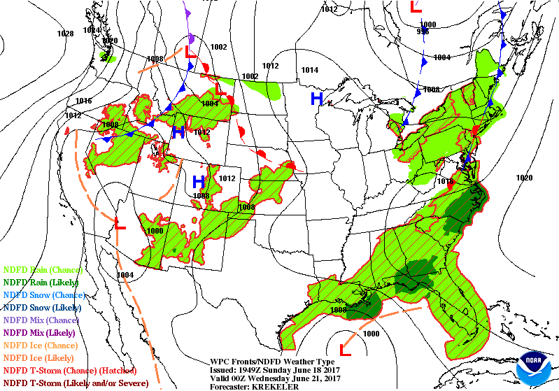
Re: ATL: INVEST 93L - Discussion
WPC surface prog for Tues 8:00pm EDT
day 1-3 QPF cast
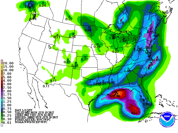
http://www.wpc.ncep.noaa.gov/index.shtml#page=ovw
day 1-3 QPF cast
http://www.wpc.ncep.noaa.gov/index.shtml#page=ovw
1 likes
-
gatorcane

- S2K Supporter
- Posts: 23708
- Age: 48
- Joined: Sun Mar 13, 2005 3:54 pm
- Location: Boca Raton, FL
Re: ATL: INVEST 93L - Discussion
We have popcorn over the NW Carib...i think we are seeing some gradual organization. Any chance a low forms closer to the MLC or more NE of the broad Yucatán low?
http://rammb.cira.colostate.edu/ramsdis ... display=12
http://rammb.cira.colostate.edu/ramsdis ... display=12
0 likes
-
tatertawt24
- Category 1

- Posts: 309
- Joined: Wed Oct 24, 2012 12:57 pm
Re: ATL: INVEST 93L - Discussion
Jeez, not in too much of a rush, is it? 
0 likes
Personal Forecast Disclaimer:
The posts in this forum are NOT official forecast and should not be used as such. They are just the opinion of the poster and may or may not be backed by sound meteorological data. They are NOT endorsed by any professional institution or storm2k.org. For official information, please refer to the NHC and NWS products.
The posts in this forum are NOT official forecast and should not be used as such. They are just the opinion of the poster and may or may not be backed by sound meteorological data. They are NOT endorsed by any professional institution or storm2k.org. For official information, please refer to the NHC and NWS products.
Who is online
Users browsing this forum: No registered users and 7 guests