ATL: CINDY - Post-Tropical - Discussion
Moderator: S2k Moderators
-
South Texas Storms

- Professional-Met

- Posts: 4258
- Joined: Thu Jun 24, 2010 12:28 am
- Location: Houston, TX
Re: ATL: INVEST 93L - Models
18z HWRF shifts west and looks to be heading to Texas on Wednesday. Down to 988mb through 57 hours.
1 likes
-
tarheelprogrammer

- S2K Supporter

- Posts: 1793
- Joined: Mon Mar 28, 2016 9:25 pm
- Location: Raleigh, NC area (Garner, NC)
Re: ATL: INVEST 93L - Models
South Texas Storms wrote:18z HWRF shifts west and looks to be heading to Texas on Wednesday. Down to 988mb through 57 hours.
It seems the models are trending stronger with the storm correct? Last run of HWRF at 12z was only at 990. Now it is at 985 heading toward Texas.
0 likes
My posts are not official forecasts. They are just my opinion and may or may not be backed by sound meteorological data. They are NOT endorsed by any professional institution or storm2k.org. For official information, please refer to the NHC and NWS products.

Re: ATL: INVEST 93L - Discussion
Yeah, floridasun, it's splitting off and shifting SW. High pressure building over top as that splits off would probably be the reason it would strengthen later on. But it's not a classic pattern reversal type system you sometimes see in June and October. It's a little different from that type of scenario.
0 likes
-
South Texas Storms
- Professional-Met
- Posts: 4258
- Joined: Thu Jun 24, 2010 12:28 am
- Location: Houston, TX
Re: ATL: INVEST 93L - Models
tarheelprogrammer wrote:South Texas Storms wrote:18z HWRF shifts west and looks to be heading to Texas on Wednesday. Down to 988mb through 57 hours.
It seems the models are trending stronger with the storm correct? Last run of HWRF at 12z was only at 990. Now it is at 985 heading toward Texas.
Yeah at least the HWRF is. Makes landfall near Galveston late Wednesday afternoon at 984 mb.
1 likes
-
wxman57

- Moderator-Pro Met

- Posts: 23174
- Age: 68
- Joined: Sat Jun 21, 2003 8:06 pm
- Location: Houston, TX (southwest)
Re: ATL: INVEST 93L - Models
South Texas Storms wrote:tarheelprogrammer wrote:South Texas Storms wrote:18z HWRF shifts west and looks to be heading to Texas on Wednesday. Down to 988mb through 57 hours.
It seems the models are trending stronger with the storm correct? Last run of HWRF at 12z was only at 990. Now it is at 985 heading toward Texas.
Yeah at least the HWRF is. Makes landfall near Galveston late Wednesday afternoon at 984 mb.
Too much GFS input in that HWRF. I don't trust it.
1 likes


-
stormhunter7

- Category 2

- Posts: 763
- Joined: Mon May 26, 2008 3:13 pm
- Location: Panama City Beach, Florida
- Contact:
Re: ATL: INVEST 93L - Discussion
Just out of curiosity, is the 18z data starting with 35kts? If so, where is the ground dat a showing 30kts?
0 likes
The following post is NOT an official forecast and should not be used as such. It is just the opinion of the poster and may or may not be backed by sound meteorological data. It is NOT endorsed by any professional institution including storm2k.org For Official Information please refer to the NHC and NWS products. http://www.nhc.noaa.gov
-
Dean4Storms
- S2K Supporter
- Posts: 6358
- Age: 63
- Joined: Sun Aug 31, 2003 1:01 pm
- Location: Miramar Bch. FL
Re: ATL: INVEST 93L - Discussion
You can actually see the system getting into a COL between the ridge building in from the west as the ULL digs SW and the Atlantic ridge. The question becomes does the ULL keep it disorganized enough to pull it more westward or does it organize enough to feel the weakness on the western flank of the Atlantic Ridge and turn more northward?
0 likes
Re: ATL: INVEST 93L - Discussion
Dean4Storms wrote:You can actually see the system getting into a COL between the ridge building in from the west as the ULL digs SW and the Atlantic ridge. The question becomes does the ULL keep it disorganized enough to pull it more westward or does it organize enough to feel the weakness on the western flank of the Atlantic Ridge and turn more northward?
I really don't think the level of organization matters one way or the other for 92L. I think it's speed of ascent north in this particular case, because the window to North Florida looks to close by Wednesday.
0 likes
-
Stormcenter
- S2K Supporter
- Posts: 6689
- Joined: Wed Sep 03, 2003 11:27 am
- Location: Houston, TX

Re: ATL: INVEST 93L - Discussion
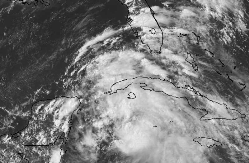
Compared to this same time yesterday it has definitely gotten better organized during the past 24 hrs despite having a broad surface low, but as many are saying you can see that the vorticity is getting better organized over the Yucatan Channel.
0 likes
-
Digital-TC-Chaser
Re: ATL: INVEST 93L - Models

The 18z GFS was looking more a large monsoon depression i think rather
than a subtropical storm. It was a big shift west from previous run.
0 likes
-
Dean4Storms
- S2K Supporter
- Posts: 6358
- Age: 63
- Joined: Sun Aug 31, 2003 1:01 pm
- Location: Miramar Bch. FL
Re: ATL: INVEST 93L - Discussion
Steve wrote:Dean4Storms wrote:You can actually see the system getting into a COL between the ridge building in from the west as the ULL digs SW and the Atlantic ridge. The question becomes does the ULL keep it disorganized enough to pull it more westward or does it organize enough to feel the weakness on the western flank of the Atlantic Ridge and turn more northward?
I really don't think the level of organization matters one way or the other for 92L. I think it's speed of ascent north in this particular case, because the window to North Florida looks to close by Wednesday.
I know you mean 93L, but I think organization has played a role in the past guidance of the GFS and GEM in developing a more organized system and thus the turn more Northward or NNE and why the ECM has kept it low key and more westward track.
1 likes

Re: ATL: INVEST 93L - Models
Hasn't even became a depression yet so wouldn't depend on models until we have a storm..
0 likes
-
Aric Dunn
- Category 5

- Posts: 21238
- Age: 43
- Joined: Sun Sep 19, 2004 9:58 pm
- Location: Ready for the Chase.
- Contact:
Re: ATL: INVEST 93L - Discussion
Check out the bouy data here. wind direction the several hours.. whatever is happening appears to taking shape near or on top the bouy.
06 18 7:40 pm SSE 9.7 13.6 - - - - 29.72 - 77.9 83.8 75.7 - - -
06 18 7:30 pm SE 5.8 9.7 - - - - 29.71 - 77.7 83.8 75.4 - - -
06 18 7:20 pm SE 3.9 9.7 - - - - 29.71 - 77.5 83.8 75.2 - - -
06 18 7:10 pm S 1.9 3.9 - - - - 29.70 - 77.5 83.8 75.2 - - -
06 18 7:00 pm SW 1.9 5.8 - - - - 29.70 +0.00 77.4 83.8 75.0 - - -
06 18 6:50 pm WSW 1.9 5.8 8.5 9 7.1 E 29.69 - 77.0 83.8 74.7 - - -
06 18 6:40 pm WSW 3.9 7.8 - - - - 29.69 - 77.2 83.7 75.2 - - -
06 18 6:30 pm S 3.9 7.8 - - - - 29.70 - 77.0 83.8 75.0 - - -
06 18 6:20 pm S 7.8 11.7 - - - - 29.70 - 77.2 83.7 75.6 - -
2 likes
Note: If I make a post that is brief. Please refer back to previous posts for the analysis or reasoning. I do not re-write/qoute what my initial post said each time.
If there is nothing before... then just ask
Space & Atmospheric Physicist, Embry-Riddle Aeronautical University,
I believe the sky is falling...
If there is nothing before... then just ask
Space & Atmospheric Physicist, Embry-Riddle Aeronautical University,
I believe the sky is falling...
Re: ATL: INVEST 93L - Discussion
Dean4Storms wrote:Steve wrote:Dean4Storms wrote:You can actually see the system getting into a COL between the ridge building in from the west as the ULL digs SW and the Atlantic ridge. The question becomes does the ULL keep it disorganized enough to pull it more westward or does it organize enough to feel the weakness on the western flank of the Atlantic Ridge and turn more northward?
I really don't think the level of organization matters one way or the other for 92L. I think it's speed of ascent north in this particular case, because the window to North Florida looks to close by Wednesday.
I know you mean 93L, but I think organization has played a role in the past guidance of the GFS and GEM in developing a more organized system and thus the turn more Northward or NNE and why the ECM has kept it low key and more westward track.
Yeah 93L, my bad. CMC did organize it faster, but both took pieces from farther east (presumably today's midlevel spin) and brought it up north quickly. Alyono was talking about that on Thursday where CMC and GFS were actually organizing a separate area. Landfall was to be Tuesday night. The way I remember running them, It's not that they were organizing it any deeper than what they're doing now. But both were quicker North than ECMWF. That model just propagated the broader low across the Yucatan and into the BoC and never did much with it until more recent runs. Some of the earlier FL runs began from farther east than where the LLC is located. You still could be right, but the way I was looking at it was that models (except earlier runs of EC) were developing it anyway. It's just that the ones that landfalled in Florida were like 36-48 hours faster.
1 likes
Re: ATL: INVEST 93L - Models
At the end neither the GFS nor the Euro will be the big winner of its final track, they have been trending towards each other, it never fails.
2 likes
-
stormreader
Re: ATL: INVEST 93L - Models
Really not a lover of any particular model. I take each storm on its own terms and weigh info given by major models then. But if this storm makes a Texas landfall, it will definitely be a bummer for the GFS. To post what models were saying last week in the 9 day time frame is not very relevant. As we got to about 7 days or so the Euro started pointing Tex-Mex. GFS was toward Appalachicola. We are in 4-5 day frame now, GFS is where, SE La or so??. If this becomes Texas landfall, GFS will have nothing to brag about. Every storm different brings new variables. Long season ahead. Perhaps the GFS can salvage something here with a landfall in SE La, but I wouldn't count on it.
0 likes
Re: ATL: INVEST 93L - Models
Agreed NDG so hoping everyone tamps down on the modeling wars. Neither has been stellar
Last edited by caneman on Sun Jun 18, 2017 7:34 pm, edited 1 time in total.
1 likes
-
Kingarabian

- S2K Supporter
- Posts: 16364
- Joined: Sat Aug 08, 2009 3:06 am
- Location: Honolulu, Hawaii
Re: ATL: INVEST 93L - Models
12z Euro Parallel is a weak TS making landfall over central Texas. LLC gets decoupled and is pushed SWS just north of Brownsville and the main vort moves in land.
0 likes
RIP Kobe Bryant
Who is online
Users browsing this forum: No registered users and 47 guests