ATL: CINDY - Post-Tropical - Discussion
Moderator: S2k Moderators
-
stormlover2013
Re: ATL: INVEST 93L - Models
I remember Humberto, disturbance to hurricane overnight I don't trust anything in the gulf, u never know
0 likes
Re: ATL: INVEST 93L - Models
stormreader wrote:Really not a lover of any particular model. I take each storm on its own terms and weigh info given by major models then. But if this storm makes a Texas landfall, it will definitely be a bummer for the GFS. To post what models were saying last week in the 9 day time frame is not very relevant. As we got to about 7 days or so the Euro started pointing Tex-Mex. GFS was toward Appalachicola. We are in 4-5 day frame now, GFS is where, SE La or so??. If this becomes Texas landfall, GFS will have nothing to brag about. Every storm different brings new variables. Long season ahead. Perhaps the GFS can salvage something here with a landfall in SE La, but I wouldn't count on it.
Please stop with the modeling comparisons. The Euro has also offered several solutions from East Pac. To Mexico to Texas to development, no development, back to development, no development.
Neither has been stellar. That's why we use the NHC blend.
0 likes

Re: ATL: INVEST 93L - Models
not sure I believe the decoupling. We are going to have the system coming under the influence of a ridge, so I am having a hard time buying a scenario with strong enough shear to cause decoupling
2 likes
-
Kingarabian

- S2K Supporter

- Posts: 16364
- Joined: Sat Aug 08, 2009 3:06 am
- Location: Honolulu, Hawaii
Re: ATL: INVEST 93L - Models
Alyono wrote:not sure I believe the decoupling. We are going to have the system coming under the influence of a ridge, so I am having a hard time buying a scenario with strong enough shear to cause decoupling
I don't know what then, because it's the 2nd run showing this scenario. And the Euro does not have it all top impressive through most of the course.
0 likes
RIP Kobe Bryant
-
Digital-TC-Chaser
Re: ATL: INVEST 93L - Models
pcolaman wrote:Hasn't even became a depression yet so wouldn't depend on models until we have a storm..
Not that it matters in this basin but be aware it is listed on jtwc as a 35kt storm atm.
93L INVEST 170618 1800 19.0N 87.1W ATL 35 1006
1 likes

Re: ATL: INVEST 93L - Models
You guys, the NHC calling this a tropical cyclone doesn't flip some magic switch in the models to make them work better.
5 likes
-
cycloneye

- Admin

- Posts: 149472
- Age: 69
- Joined: Thu Oct 10, 2002 10:54 am
- Location: San Juan, Puerto Rico
Re: ATL: INVEST 93L - Discussion
00z Best track:
As of 00:00 UTC Jun 19, 2017:
Location: 19.8°N 87.0°W
Maximum Winds: 35 kt Gusts: N/A
Minimum Central Pressure: 1004 mb
Environmental Pressure: 1008 mb
Radius of Circulation: 240 NM
Radius of Maximum Wind: 200 NM
As of 00:00 UTC Jun 19, 2017:
Location: 19.8°N 87.0°W
Maximum Winds: 35 kt Gusts: N/A
Minimum Central Pressure: 1004 mb
Environmental Pressure: 1008 mb
Radius of Circulation: 240 NM
Radius of Maximum Wind: 200 NM
1 likes
Visit the Caribbean-Central America Weather Thread where you can find at first post web cams,radars
and observations from Caribbean basin members Click Here
and observations from Caribbean basin members Click Here

-
Digital-TC-Chaser
Re: ATL: INVEST 93L - Models
The models do however get a better grasp on a organised low with steering.
Weak nothings tend to be erratic.
Weak nothings tend to be erratic.
0 likes

Re: ATL: INVEST 93L - Models
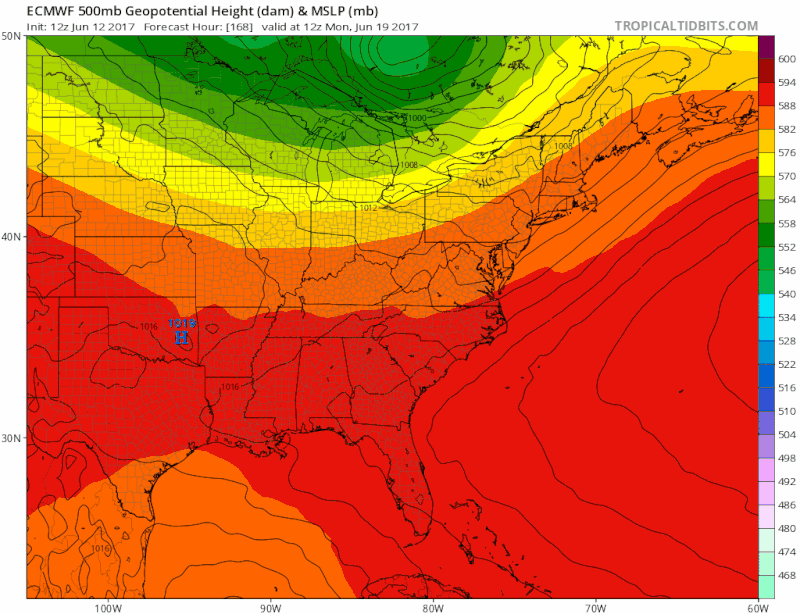
Good example of how the Euro has been over doing the ridging across the north central gulf coast, this is why it will continue to trend towards a landfall of northern TX coast of SW LA as we get closer in time, IMO.
2 likes
-
TeamPlayersBlue

- Category 5

- Posts: 3530
- Joined: Tue Feb 02, 2010 1:44 am
- Location: Denver/Applewood, CO
Re: ATL: INVEST 93L - Discussion
Wow. That best track aint too shabby.
1 likes
Personal Forecast Disclaimer:
The posts in this forum are NOT official forecast and should not be used as such. They are just the opinion of the poster and may or may not be backed by sound meteorological data. They are NOT endorsed by any professional institution or storm2k.org. For official information, please refer to the NHC and NWS products.
The posts in this forum are NOT official forecast and should not be used as such. They are just the opinion of the poster and may or may not be backed by sound meteorological data. They are NOT endorsed by any professional institution or storm2k.org. For official information, please refer to the NHC and NWS products.
-
floridasun78
- Category 5
- Posts: 3755
- Joined: Sun May 17, 2009 10:16 pm
- Location: miami fl

Re: ATL: INVEST 93L - Discussion
cycloneye wrote:00z Best track:
As of 00:00 UTC Jun 19, 2017:
Location: 19.8°N 87.0°W
Maximum Winds: 35 kt Gusts: N/A
Minimum Central Pressure: 1004 mb
Environmental Pressure: 1008 mb
Radius of Circulation: 240 NM
Radius of Maximum Wind: 200 NM
So directly to TS if this can manage to organize at some point.
0 likes
The above post is not official and should not be used as such. It is the opinion of the poster and may or may not be backed by sound meteorological data. It is not endorsed by any professional institution or storm2k.org. For official information, please refer to the NHC and NWS products.
-
stormreader
Re: ATL: INVEST 93L - Models
NDG wrote:Good example of how the Euro has been over doing the ridging across the north central gulf coast, this is why it will continue to trend towards a landfall of northern TX coast of SW LA as we get closer in time, IMO.
May be right. About 36 hours or so ago we started to see hints from the western assortment of models of a possible run north during the later period toward the upper Texas coast. This is why I always included the Tex-La border as a possibility to be included with the Texas landfall scenario.
1 likes
Re: ATL: INVEST 93L - Models
1 likes
The above post is not official and should not be used as such. It is the opinion of the poster and may or may not be backed by sound meteorological data. It is not endorsed by any professional institution or storm2k.org. For official information, please refer to the NHC and NWS products.
-
cycloneye
- Admin
- Posts: 149472
- Age: 69
- Joined: Thu Oct 10, 2002 10:54 am
- Location: San Juan, Puerto Rico
Re: ATL: INVEST 93L - Discussion
0 likes
Visit the Caribbean-Central America Weather Thread where you can find at first post web cams,radars
and observations from Caribbean basin members Click Here
and observations from Caribbean basin members Click Here
-
TropicalAnalystwx13

- Category 5
- Posts: 2109
- Age: 28
- Joined: Tue Jul 19, 2011 8:20 pm
- Location: Wilmington, NC
- Contact:
Re: ATL: INVEST 93L - Discussion
It'll be interesting to see how the system develops in the Gulf of Mexico with proximity to the upper-level low farther west. We may be dealing with something that looks like Lee, with an exposed circulation and all weather north and east of the center--something that could border on being subtropical. I tend to favor the northwestern Gulf (Texas/Louisiana) as a landfall point, since models have slowed the system down over coming days. That should allow more time for the East Coast trough to lift out and ridging to develop, forcing 93L on a west-northwest track after initially moving north. Regardless, it'll be a typical June storm--messy, short-lived, with heavy rainfall as the main threat.
0 likes
Re: ATL: INVEST 93L - Discussion
Vorticity location could support something closer to the GFS (over the Euro) track.
0 likes
The above post is not official and should not be used as such. It is the opinion of the poster and may or may not be backed by sound meteorological data. It is not endorsed by any professional institution or storm2k.org. For official information, please refer to the NHC and NWS products.
-
gatorcane

- S2K Supporter
- Posts: 23708
- Age: 48
- Joined: Sun Mar 13, 2005 3:54 pm
- Location: Boca Raton, FL
Re: ATL: INVEST 93L - Discussion
The upper trough over the NW Gulf seems to have gone stationary again. Tough for this system to move west into that.

1 likes
Who is online
Users browsing this forum: No registered users and 50 guests