
I don't know. I was thinking earlier today that I haven't looked at almost any upper dynamics this entire week. That's kind of a shame, but I guess I need to shake off the rust early this year.
Latest spaghetti plots with 00 BAMs and 18 GFSs show a pretty clear track NNW toward S LA. I haven't been thinking this was a Louisiana storm beyond feeder rains if it got over toward the TX Coast. If so, it's the Bill 03 track or close to it. I still think maybe a move toward the coast with the hook west if it can't come up any farther (sort of the NAM/HWRF solution mixed). NAM is out to 9 hours and shows broad circulation north of the Yucatan. At 15 hours the circulation is kind of angled toward FL in a Yin Yang configuration with the nose of the UL splitting off SW to its west.
1001mb at 21 hours going north with a jog NE toward the convection. A sign or just a jump?
Just a jump. Clearly a western component by 27 hours. it's 999/1000 on the 12km resolution at 27.
It sort of fluctuates between 27 and 33 hours but at 33 hours it's down to 997 and maybe 150/160? miles south of Boothville & Venice.
ATL: CINDY - Post-Tropical - Discussion
Moderator: S2k Moderators
Re: ATL: INVEST 93L - Models
Last edited by Steve on Sun Jun 18, 2017 9:12 pm, edited 1 time in total.
0 likes
-
stormreader
Re: ATL: INVEST 93L - Discussion
cycloneye wrote:00z Best track:
As of 00:00 UTC Jun 19, 2017:
Location: 19.8°N 87.0°W
Maximum Winds: 35 kt Gusts: N/A
Minimum Central Pressure: 1004 mb
Environmental Pressure: 1008 mb
Radius of Circulation: 240 NM
Radius of Maximum Wind: 200 NM
So 1004 my now. Pressure drop. Wouldn't be surprised either at an immediate upgrade to tropical storm at point of emergence in coastal waters of N Yucatan.
0 likes
-
bamajammer4eva
- Category 4

- Posts: 907
- Joined: Sun Apr 18, 2010 3:21 am
- Location: Ozark, AL

Re: ATL: INVEST 93L - Models
NAM brings a piece of upper energy from the continent and moves it toward the SW and upper low just ahead of 93L which starts hooking wsw-southwest which I think is going to be west at first unless it's dropping a loop or caught in the flow around the high pressure to its west. That's at 39 hours, but it's 995mb and apparently strengthening. I'm thinking it will still end up somewhere around Brownsville, but half the run still has to go.
0 likes
-
TheStormExpert
Re: ATL: INVEST 93L - Models
Déjà Vu! Looks a lot like a Cindy(2005) repeat looking at the track guidance as of 00z.
https://twitter.com/hurrtrackerapp/status/876615620225363968
https://en.wikipedia.org/wiki/Hurricane_Cindy_(2005)
https://twitter.com/hurrtrackerapp/status/876615620225363968
https://en.wikipedia.org/wiki/Hurricane_Cindy_(2005)
0 likes
-
stormhunter7

- Category 2

- Posts: 763
- Joined: Mon May 26, 2008 3:13 pm
- Location: Panama City Beach, Florida
- Contact:
Re: ATL: INVEST 93L - Discussion
That the ULL just south of LA in the WV imagery? Btw, would they go to potential tropical cyclone three with 93l?
0 likes
The following post is NOT an official forecast and should not be used as such. It is just the opinion of the poster and may or may not be backed by sound meteorological data. It is NOT endorsed by any professional institution including storm2k.org For Official Information please refer to the NHC and NWS products. http://www.nhc.noaa.gov
Re: ATL: INVEST 93L - Models
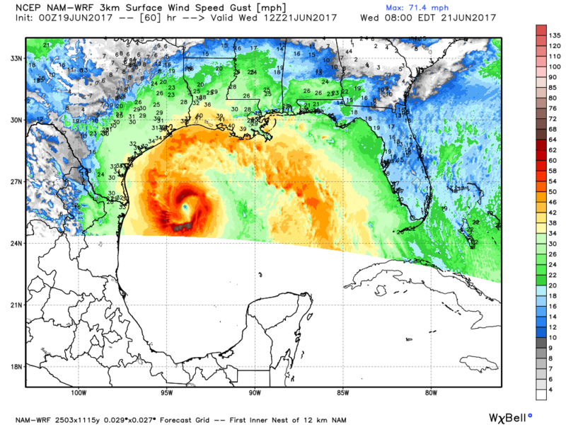
72 hours, south of the Sabine River and due east of Matamoros. It never really strengthens it beyond 995 or 994, but it's mostly around 998 or so. At the end of the run between 72 and 84 hours, it makes a run for Cameron, Louisiana. Run ends before landfall, so it could easily be between Jefferson Co. Texas and Vermilion Parish, Louisiana. 84 hours from 7 pm is 7 am Thursday. Looks like everyone to the east gets wet in this run. The 3km only goes out to 60 hours, but it shows 989mb.
0 likes
-
CYCLONE MIKE
- Category 5

- Posts: 2183
- Joined: Tue Aug 31, 2004 6:04 pm
- Location: Gonzales, LA
Re: ATL: INVEST 93L - Models
If that comes close to verifying Steve, south la has the potential to see a repeat of last summers historic floods all over again. Pretty much worse case scenario for this system.
1 likes
This post is NOT AN OFFICIAL FORECAST and should not be used as such. It is just the opinion of the poster and may or may not be backed by sound meteorological data. It is NOT endorsed by any professional institution including storm2k.org. For Official Information please refer to the NHC and NWS products.
-
stormreader
Re: ATL: INVEST 93L - Models
CYCLONE MIKE wrote:If that comes close to verifying Steve, south la has the potential to see a repeat of last summers historic floods all over again. Pretty much worse case scenario for this system.
Most definitely. Landfall around Sabine River with all that moisture to the east. Not good for entire state of La.
1 likes
-
Wx_Warrior
- Category 5
- Posts: 2718
- Joined: Thu Aug 03, 2006 3:58 pm
- Location: Beaumont, TX

-
Rgv20

- S2K Supporter

- Posts: 2466
- Age: 39
- Joined: Wed Jan 05, 2011 5:42 pm
- Location: Edinburg/McAllen Tx
Re: ATL: INVEST 93L - Models
0zNAM 3KM develops a stunning cyclone by Wednesday morning.... 

0 likes
The following post is NOT an official forecast and should not be used as such. It is just the opinion of the poster and may or may not be backed by sound meteorological data. It is NOT endorsed by any professional institution including storm2k.org For Official Information please refer to the NHC and NWS products.

Re: ATL: INVEST 93L - Models
Question to the mets here: What is the chance of northern Georgia getting some rain out of this? It's been somewhat dry here over the longer term.
0 likes
The above post is not official and should not be used as such. It is the opinion of the poster and may or may not be backed by sound meteorological data. It is not endorsed by any professional institution or storm2k.org. For official information, please refer to the NHC and NWS products.
-
PTrackerLA

- Category 5
- Posts: 5281
- Age: 42
- Joined: Thu Oct 10, 2002 8:40 pm
- Location: Lafayette, LA
Re: ATL: INVEST 93L - Models
Steve wrote:NAM brings a piece of upper energy from the continent and moves it toward the SW and upper low just ahead of 93L which starts hooking wsw-southwest which I think is going to be west at first unless it's dropping a loop or caught in the flow around the high pressure to its west. That's at 39 hours, but it's 995mb and apparently strengthening. I'm thinking it will still end up somewhere around Brownsville, but half the run still has to go.
It's crazy how interesting things are about to get in the Gulf and it's mid-June. Feels like ages since we've had and early season system to monitor on the northern/northwestern gulf coast. Someone is going to get pounded with some flooding rains, gulf coast residents need to be on alert. 00z Canadian is into Sabine Pass at 998mb. The NAM 3km runs have been interesting, looks to want to develop a meandering hurricane by 60 hours. Should we take this new resolution of the NAM in the subtropics with a grain of salt like the others?
1 likes
-
stormlover2013
Re: ATL: INVEST 93L - Models
I mean is the gfs going to get this right or euro seems to me gfs sticking with its guns
0 likes
-
TropicalAnalystwx13

- Category 5
- Posts: 2109
- Age: 28
- Joined: Tue Jul 19, 2011 8:20 pm
- Location: Wilmington, NC
- Contact:
Re: ATL: INVEST 93L - Models
Rgv20 wrote:0zNAM 3KM develops a stunning cyclone by Wednesday morning....
And that's why NAM isn't used for tropical cyclones. It had Hermine as a Category 4 at landfall last year.
0 likes
-
Digital-TC-Chaser
Re: ATL: INVEST 93L - Models


GEFS is still a cane with all the usual issue's surge inundation + rain flooding.
1 likes
Re: ATL: INVEST 93L - Models
PTrackerLA wrote:Steve wrote:NAM brings a piece of upper energy from the continent and moves it toward the SW and upper low just ahead of 93L which starts hooking wsw-southwest which I think is going to be west at first unless it's dropping a loop or caught in the flow around the high pressure to its west. That's at 39 hours, but it's 995mb and apparently strengthening. I'm thinking it will still end up somewhere around Brownsville, but half the run still has to go.
It's crazy how interesting things are about to get in the Gulf and it's mid-June. Feels like ages since we've had and early season system to monitor on the northern/northwestern gulf coast. Someone is going to get pounded with some flooding rains, gulf coast residents need to be on alert. 00z Canadian is into Sabine Pass at 998mb. The NAM 3km runs have been interesting, looks to want to develop a meandering hurricane by 60 hours. Should we take this new resolution of the NAM in the subtropics with a grain of salt like the others?
Idk. I suspect it will be hit and miss like the rest of them. But if we get any WSW movement a stall a bit east of Brownsville and a run for the TX/LA Border, maybe it's time we rethink its contribution. Looks like the highest rainfall (actually mustard to brown on their chart) on the QPF chart is centered in a box around Hancock County, offshore waters, and St. Bernard and Plaquemines Parishes. I'm thinking some street flooding around and about. Hopefully with a western moving system, some of the coastal parishes don't flood. I don't think this will be strong enough outside of some coastal flooding from the winds and tides, but remember that lower Terrebonne Parish south of Houma had thousands of flooded homes because of Ike which was nowhere near the coast. Inland flash flooding looks like maybe an issue too. I guess we'll know pretty soon.
0 likes
-
StLucieStorm
- Tropical Wave

- Posts: 4
- Joined: Sat Jun 17, 2017 11:11 am
Re: ATL: INVEST 93L - Discussion
00z current surface analysis appears to depict a 1000 mb low moving due north in the general direction of the panhandle. Does anybody know how much the ULL may be influencing this?
0 likes
-
Aric Dunn
- Category 5
- Posts: 21238
- Age: 43
- Joined: Sun Sep 19, 2004 9:58 pm
- Location: Ready for the Chase.
- Contact:
Re: ATL: INVEST 93L - Discussion
StLucieStorm wrote:00z current surface analysis appears to depict a 1000 mb low moving due north in the general direction of the panhandle. Does anybody know how much the ULL may be influencing this?
well in general any convection will build in the direction of mid and upper divergence. the current set up is drawing the convection to build northward along the trough axis and greatest divergence. watching the PW loop shows this quite clearly .
this is why a lot of the models have the northern part of the trough close off and move more northerly .. which is what appears to be the case at the moment. once a llc is defined ( not likely going to be so close to the mexican coast and that south ) the models are likely to jump onto the northerly track.
The northern "lobe" will keel over once in the southern GOM somewhere from north of the yucatan or the straight. wont make it to far west.
by morning/ midday we should have a very clear llc though it will likely be somewhat void of convection initially .
Last edited by Aric Dunn on Mon Jun 19, 2017 12:14 am, edited 1 time in total.
1 likes
Note: If I make a post that is brief. Please refer back to previous posts for the analysis or reasoning. I do not re-write/qoute what my initial post said each time.
If there is nothing before... then just ask
Space & Atmospheric Physicist, Embry-Riddle Aeronautical University,
I believe the sky is falling...
If there is nothing before... then just ask
Space & Atmospheric Physicist, Embry-Riddle Aeronautical University,
I believe the sky is falling...
Who is online
Users browsing this forum: No registered users and 35 guests