ATL: CINDY - Post-Tropical - Discussion

Moderator: S2k Moderators

Message
Author
Aric Dunn
Category 5
Category 5
Posts: 21238
Age: 42
Joined: Sun Sep 19, 2004 9:58 pm
Location: Ready for the Chase.
Contact:

Re: ATL: INVEST 93L - Discussion

#401 Postby Aric Dunn » Mon Jun 19, 2017 12:18 am

stormlover2013 wrote:Eric u leaning towards gfs?


unfortunately im not with any model right now since none are initialized correctly. they are all initialized to far south and west and too slow. the center will take shape just north of the yucatan somewhere by morning ish.

if it develops farther east then the trough will likely snag it. if farther west then it might get left behind. another 12 hours will give us much better insight.
1 likes   
Note: If I make a post that is brief. Please refer back to previous posts for the analysis or reasoning. I do not re-write/qoute what my initial post said each time.
If there is nothing before... then just ask :)

Space & Atmospheric Physicist, Embry-Riddle Aeronautical University,
I believe the sky is falling...

Aric Dunn
Category 5
Category 5
Posts: 21238
Age: 42
Joined: Sun Sep 19, 2004 9:58 pm
Location: Ready for the Chase.
Contact:

Re: ATL: INVEST 93L - Discussion

#402 Postby Aric Dunn » Mon Jun 19, 2017 12:23 am

personal thoughts are leaning towards northern gulf florida panhandle to MI


sheared system with a center constantly reforming N to NNE eastward eventually getting caught in the trough before it lifts out.

but could stay weaker and survive and make it farther west get left behind and slowly move towards upper texas to mid texas coast.
1 likes   
Note: If I make a post that is brief. Please refer back to previous posts for the analysis or reasoning. I do not re-write/qoute what my initial post said each time.
If there is nothing before... then just ask :)

Space & Atmospheric Physicist, Embry-Riddle Aeronautical University,
I believe the sky is falling...

Aric Dunn
Category 5
Category 5
Posts: 21238
Age: 42
Joined: Sun Sep 19, 2004 9:58 pm
Location: Ready for the Chase.
Contact:

Re: ATL: INVEST 93L - Discussion

#403 Postby Aric Dunn » Mon Jun 19, 2017 12:30 am

if you look. latest surface obs are showing the low level flow bulging north just off shore the Yucatan still broad but by tomorrow midday convection will have spread to the north side in the central gulf.

Image
0 likes   
Note: If I make a post that is brief. Please refer back to previous posts for the analysis or reasoning. I do not re-write/qoute what my initial post said each time.
If there is nothing before... then just ask :)

Space & Atmospheric Physicist, Embry-Riddle Aeronautical University,
I believe the sky is falling...

StLucieStorm
Tropical Wave
Tropical Wave
Posts: 4
Joined: Sat Jun 17, 2017 11:11 am

Re: ATL: INVEST 93L - Discussion

#404 Postby StLucieStorm » Mon Jun 19, 2017 12:43 am

That appears to be along the lines of what i was thinking. Upper level steering currents certainly seem to support at least the possibility of a Panhandle strike. It's insane to me the lack of any sort of attention to this system from any local mets. The proximity alone makes this system one worth watching.
2 likes   

Digital-TC-Chaser

Re: ATL: INVEST 93L - Discussion

#405 Postby Digital-TC-Chaser » Mon Jun 19, 2017 12:49 am

To be fair on your local mets cimss shear atm is not supporting a storm in the GOM.
http://tropic.ssec.wisc.edu/real-time/w ... oom=&time=
0 likes   

Aric Dunn
Category 5
Category 5
Posts: 21238
Age: 42
Joined: Sun Sep 19, 2004 9:58 pm
Location: Ready for the Chase.
Contact:

Re: ATL: INVEST 93L - Discussion

#406 Postby Aric Dunn » Mon Jun 19, 2017 12:52 am

Digital-TC-Chaser wrote:To be fair on your local mets cimss shear atm is not supporting a storm.

well that depends on the initialization in the models..
0 likes   
Note: If I make a post that is brief. Please refer back to previous posts for the analysis or reasoning. I do not re-write/qoute what my initial post said each time.
If there is nothing before... then just ask :)

Space & Atmospheric Physicist, Embry-Riddle Aeronautical University,
I believe the sky is falling...

StLucieStorm
Tropical Wave
Tropical Wave
Posts: 4
Joined: Sat Jun 17, 2017 11:11 am

Re: ATL: INVEST 93L - Discussion

#407 Postby StLucieStorm » Mon Jun 19, 2017 12:54 am

Genesis does appear to be more likely then not at this point. While i do understand the concept of not ringing alarm bells unduly and so forth, the amount of people that do not even know of the existence of any sort of tropical threat is astounding. A sheared mess it may be, but after recent sustained heavy rains for many on the florida panhandle the soil is extremely saturated. Ending up on the east side of a convectively lopsided system could certainly be a very large headache or more for many.
1 likes   

StLucieStorm
Tropical Wave
Tropical Wave
Posts: 4
Joined: Sat Jun 17, 2017 11:11 am

Re: ATL: INVEST 93L - Discussion

#408 Postby StLucieStorm » Mon Jun 19, 2017 12:55 am

I apologise. Recent heavy rains on the peninsula is what i meant.
1 likes   

stormreader

Re: ATL: INVEST 93L - Models

#409 Postby stormreader » Mon Jun 19, 2017 12:58 am

TropicalAnalystwx13 wrote:
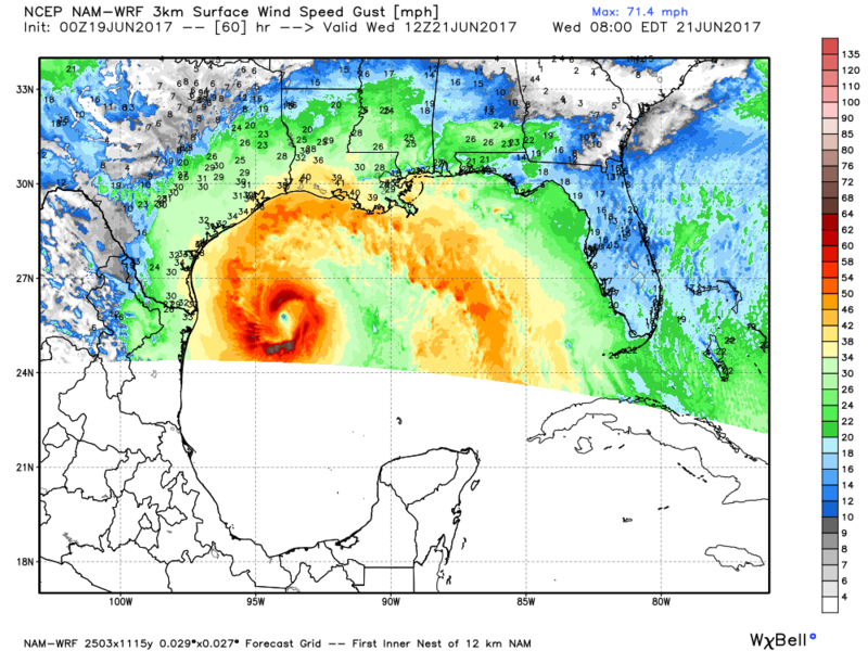
Rgv20 wrote:0zNAM 3KM develops a stunning cyclone by Wednesday morning.... :eek:

Image

And that's why NAM isn't used for tropical cyclones. It had Hermine as a Category 4 at landfall last year. :lol:

Point well taken. However, I think we may need to look at a reasonable chance of a June hurricane in the central-west gulf. Almost all models are showing a more significant storm now than they did three days ago. The GFS, which I think is too east has been hinting at a hurricane for a day or two. If higher pressure ridges in a little stronger over the SE US you could have very positive conditions for development.
0 likes   

Digital-TC-Chaser

Re: ATL: INVEST 93L - Discussion

#410 Postby Digital-TC-Chaser » Mon Jun 19, 2017 12:58 am

Aric Dunn wrote:
Digital-TC-Chaser wrote:To be fair on your local mets cimss shear atm is not supporting a storm.

well that depends on the initialization in the models..

No doubts the models are all showing a storm in the GOM. If those shear values hold up
there will be no anvils on the thunderstorms.
0 likes   

paintplaye
Category 1
Category 1
Posts: 380
Joined: Sun Jul 20, 2008 11:25 pm

Re: ATL: INVEST 93L - Models

#411 Postby paintplaye » Mon Jun 19, 2017 12:59 am

00z ECMWF is trying to develop the northern vorticity similar to the GFS. Still has a similar track though to 12z at 36H out.
0 likes   

Aric Dunn
Category 5
Category 5
Posts: 21238
Age: 42
Joined: Sun Sep 19, 2004 9:58 pm
Location: Ready for the Chase.
Contact:

Re: ATL: INVEST 93L - Discussion

#412 Postby Aric Dunn » Mon Jun 19, 2017 12:59 am

Digital-TC-Chaser wrote:
Aric Dunn wrote:
Digital-TC-Chaser wrote:To be fair on your local mets cimss shear atm is not supporting a storm.

well that depends on the initialization in the models..

No doubts the models are all showing a storm in the GOM. If those shear values hold up
there will be no anvils on the thunderstorms.


or a deepening hurricane lol ... still to early..
0 likes   
Note: If I make a post that is brief. Please refer back to previous posts for the analysis or reasoning. I do not re-write/qoute what my initial post said each time.
If there is nothing before... then just ask :)

Space & Atmospheric Physicist, Embry-Riddle Aeronautical University,
I believe the sky is falling...

User avatar
Hammy
Category 5
Category 5
Posts: 5849
Age: 41
Joined: Fri May 25, 2012 5:25 pm
Contact:

Re: ATL: INVEST 93L - Discussion

#413 Postby Hammy » Mon Jun 19, 2017 1:31 am

With those two massive blobs of convection going, where's the main circulation most likely to form at this point?
0 likes   
The above post is not official and should not be used as such. It is the opinion of the poster and may or may not be backed by sound meteorological data. It is not endorsed by any professional institution or storm2k.org. For official information, please refer to the NHC and NWS products.

Aric Dunn
Category 5
Category 5
Posts: 21238
Age: 42
Joined: Sun Sep 19, 2004 9:58 pm
Location: Ready for the Chase.
Contact:

Re: ATL: INVEST 93L - Discussion

#414 Postby Aric Dunn » Mon Jun 19, 2017 1:34 am

Hammy wrote:With those two massive blobs of convection going, where's the main circulation most likely to form at this point?

read what I wrote a few posts up .. :uarrow: :uarrow:
0 likes   
Note: If I make a post that is brief. Please refer back to previous posts for the analysis or reasoning. I do not re-write/qoute what my initial post said each time.
If there is nothing before... then just ask :)

Space & Atmospheric Physicist, Embry-Riddle Aeronautical University,
I believe the sky is falling...

USTropics
Professional-Met
Professional-Met
Posts: 2651
Joined: Sun Aug 12, 2007 3:45 am
Location: Florida State University

Re: ATL: INVEST 93L - Discussion

#415 Postby USTropics » Mon Jun 19, 2017 3:01 am

Aric Dunn wrote:
Hammy wrote:With those two massive blobs of convection going, where's the main circulation most likely to form at this point?

read what I wrote a few posts up .. :uarrow: :uarrow:


I think you're pretty much dead accurate. All signs point to any LLC forming off the northern coast of the Yucatan.
Image

700mb vort loop from the past 12 hours also has moved towards that location
Image

Current surface observations:
Image

Shortwave IR:
Image
2 likes   

USTropics
Professional-Met
Professional-Met
Posts: 2651
Joined: Sun Aug 12, 2007 3:45 am
Location: Florida State University

Re: ATL: INVEST 93L - Models

#416 Postby USTropics » Mon Jun 19, 2017 4:05 am

The 00z GFS solution is a reasonable one. 93L will most likely struggle to maintain an inner core, and multiple center reformations to the north/northeast is a likely outcome. You can clearly see this happening at 24 hours in the 850mb vort loop:

Image
0 likes   

USTropics
Professional-Met
Professional-Met
Posts: 2651
Joined: Sun Aug 12, 2007 3:45 am
Location: Florida State University

Re: ATL: INVEST 93L - Models

#417 Postby USTropics » Mon Jun 19, 2017 4:07 am

The 00z ECMWF run has landfall in Texas and is close to the 12z run from yesterday:

Image
0 likes   

User avatar
Kingarabian
S2K Supporter
S2K Supporter
Posts: 15980
Joined: Sat Aug 08, 2009 3:06 am
Location: Honolulu, Hawaii

Re: ATL: INVEST 93L - Models

#418 Postby Kingarabian » Mon Jun 19, 2017 4:59 am

GFS continues its shift west at 06z.
0 likes   
RIP Kobe Bryant

TheStormExpert

Re: ATL: INVEST 93L - Models

#419 Postby TheStormExpert » Mon Jun 19, 2017 5:03 am

Kingarabian wrote:GFS continues its shift west at 06z.

I don't see a shift west? Looks similar to yesterday's 18z run.
0 likes   

User avatar
NDG
S2K Supporter
S2K Supporter
Posts: 15446
Joined: Sun Jul 09, 2006 10:14 pm
Location: Orlando, FL

Re: ATL: INVEST 93L - Models

#420 Postby NDG » Mon Jun 19, 2017 5:23 am

TheStormExpert wrote:
Kingarabian wrote:GFS continues its shift west at 06z.

I don't see a shift west? Looks similar to yesterday's 18z run.


I agree, is exactly like yesterday's 18z.
0 likes   


Return to “2017”

Who is online

Users browsing this forum: No registered users and 3 guests