@EricBlake12
Agree with genesis chances- very consistent with long range guidance & https://twitter.com/nwscpc/status/889927767411879936 … (maybe late week 1 instead?)
https://twitter.com/EricBlake12/status/890600324427169792
2017 indicators: SST's / MSLP / SAL / Steering / Instability
Moderator: S2k Moderators
Forum rules

The posts in this forum are NOT official forecasts and should not be used as such. They are just the opinion of the poster and may or may not be backed by sound meteorological data. They are NOT endorsed by any professional institution or STORM2K. For official information, please refer to products from the National Hurricane Center and National Weather Service.
-
cycloneye

- Admin

- Posts: 149266
- Age: 69
- Joined: Thu Oct 10, 2002 10:54 am
- Location: San Juan, Puerto Rico
Re: 2017 indicators: SST's / MSLP / SAL / Steering / Instability
1 likes
Visit the Caribbean-Central America Weather Thread where you can find at first post web cams,radars
and observations from Caribbean basin members Click Here
and observations from Caribbean basin members Click Here
-
Hurricaneman

- Category 5

- Posts: 7404
- Age: 45
- Joined: Tue Aug 31, 2004 3:24 pm
- Location: central florida
Re: 2017 indicators: SST's / MSLP / SAL / Steering / Instability
Based on what is going on with th mjo and CCKW coming I believe the lid comes off between August 2nd and 10th and I believe week three will have some hurricanes and some major hurricanes which need to be watched as I believe that's when the best forcing comes into the Atlantic
1 likes


Re: 2017 indicators: SST's / MSLP / SAL / Steering / Instability
Something thats just a little disconcerting to me is that according to present MJO phase and current discussions of next week's advancing Kelvin wave, the Atlantic should right now be rather suppressed in terms of development (for at least a few days anyway). Contrary to that however is the complex ITCZ disturbance in the E. Atlantic that is looking rather healthy at the moment and likely to be tagged an invest later today.
Each year seems to have its quirks and persistent tendencies that underscore subtle climatic and hemispheric shift of conditions that are always taking place but sometimes less obvious to foretell. We're now seeing tendencies for quite a strong mid level ridge over the W. Atlantic to appear as at least one dominant characteristic moving forward. NWS long range modeling is projecting cooler than normal over the Great Lakes in the coming weeks perhaps indicating a further west shunted long wave pattern (as opposed to along or east of the CONUS). Further extended forecasts are calling for above average heat over nearly all of Eastern US (or perhaps the Eastern 2/3's of U.S.!). This would seem to project that there may be a pretty significant amount of ridging from the W. Atlantic and bridging westward. There are some years where convective blob after convective blob migrates westward within the easterly trades, yet some lacking of vorticity seems to be evident and those reasons vary from one year to another. This year however, it seems to me that convection in the tropics has been less diurnal and at least attempts at cyclonic development have been more frequent and more conducive than many other past years have exhibited. Its impossible to fully anticipate or "get into the weeds" about so many different factors that will play into each future developing storm or its forecast track at that moment in time but in general - "warning bells" are going off in my head. 'Course, that could just mean that I should see a doctor LOL but honestly, I'm simply echoing what a few others here have already begun to anticipate as well. I think this year is going to evolve to be quite a memorable Atlantic hurricane season in terms of overall activity, pace of development, and damage caused. I certainly hope i'm wrong about the latter.
Each year seems to have its quirks and persistent tendencies that underscore subtle climatic and hemispheric shift of conditions that are always taking place but sometimes less obvious to foretell. We're now seeing tendencies for quite a strong mid level ridge over the W. Atlantic to appear as at least one dominant characteristic moving forward. NWS long range modeling is projecting cooler than normal over the Great Lakes in the coming weeks perhaps indicating a further west shunted long wave pattern (as opposed to along or east of the CONUS). Further extended forecasts are calling for above average heat over nearly all of Eastern US (or perhaps the Eastern 2/3's of U.S.!). This would seem to project that there may be a pretty significant amount of ridging from the W. Atlantic and bridging westward. There are some years where convective blob after convective blob migrates westward within the easterly trades, yet some lacking of vorticity seems to be evident and those reasons vary from one year to another. This year however, it seems to me that convection in the tropics has been less diurnal and at least attempts at cyclonic development have been more frequent and more conducive than many other past years have exhibited. Its impossible to fully anticipate or "get into the weeds" about so many different factors that will play into each future developing storm or its forecast track at that moment in time but in general - "warning bells" are going off in my head. 'Course, that could just mean that I should see a doctor LOL but honestly, I'm simply echoing what a few others here have already begun to anticipate as well. I think this year is going to evolve to be quite a memorable Atlantic hurricane season in terms of overall activity, pace of development, and damage caused. I certainly hope i'm wrong about the latter.
4 likes
Andy D
(For official information, please refer to the NHC and NWS products.)
(For official information, please refer to the NHC and NWS products.)
-
weathaguyry

- Category 5
- Posts: 1273
- Age: 22
- Joined: Wed Jun 15, 2016 5:16 am
- Location: Long Island, NY
Re: 2017 indicators: SST's / MSLP / SAL / Steering / Instability
I really think we are getting very close to the lid coming off, with a favorable MJO and Kelvin wave moving in, it would make conditions ready to go to get a burst of activity.
0 likes
My posts are only my opinions and NOT official forecasts. For official forecasts, consult the National Hurricane Center or the National Weather Service.
Irene 11', Sandy 12', Fay 20’, Isaias 20’, Elsa 21’, Henri 21’, Ida 21’
Irene 11', Sandy 12', Fay 20’, Isaias 20’, Elsa 21’, Henri 21’, Ida 21’

Re: 2017 indicators: SST's / MSLP / SAL / Steering / Instability
I'm starting to think we could go until about the middle of August without anything forming given the models--and something that's been in the back of my mind for awhile, especially given the ITCZ pattern and steering flow, is could this year end up being a sort of 'what if' scenario of 2015 had El Nino not been present.
1 likes
The above post is not official and should not be used as such. It is the opinion of the poster and may or may not be backed by sound meteorological data. It is not endorsed by any professional institution or storm2k.org. For official information, please refer to the NHC and NWS products.


Re: 2017 indicators: SST's / MSLP / SAL / Steering / Instability
Hammy wrote:I'm starting to think we could go until about the middle of August without anything forming given the models--and something that's been in the back of my mind for awhile, especially given the ITCZ pattern and steering flow, is could this year end up being a sort of 'what if' scenario of 2015 had El Nino not been present.
Interesting idea! I had forgotten about the discussion that season about how the MDR seemed to be much more alive than previous years but was held down by the El Niño, relatively more favorable than the western half of the basin. Hard to tell at this point whether this year will feature a similar pattern (minus the El Niño) as we wait for Pacific activity to die down to give us a better glimpse into conditions in the Caribbean.
0 likes

Re: 2017 indicators: SST's / MSLP / SAL / Steering / Instability
Hurricaneman wrote:Based on what is going on with th mjo and CCKW coming I believe the lid comes off between August 2nd and 10th and I believe week three will have some hurricanes and some major hurricanes which need to be watched as I believe that's when the best forcing comes into the Atlantic
The Kelvin Wave is being over hyped here. Another SAL outbreak is coming as per the model thread
best forcing remains in the WPAC and may remain there for some time
0 likes
Re: 2017 indicators: SST's / MSLP / SAL / Steering / Instability
Hammy wrote:I'm starting to think we could go until about the middle of August without anything forming given the models--and something that's been in the back of my mind for awhile, especially given the ITCZ pattern and steering flow, is could this year end up being a sort of 'what if' scenario of 2015 had El Nino not been present.
re 2015: All you needed was the el niño to be slightly more west based for that year to have been a 1995 repeat for the islands of the eastern Caribbean
0 likes

Re: 2017 indicators: SST's / MSLP / SAL / Steering / Instability
Alyono wrote:Hurricaneman wrote:Based on what is going on with th mjo and CCKW coming I believe the lid comes off between August 2nd and 10th and I believe week three will have some hurricanes and some major hurricanes which need to be watched as I believe that's when the best forcing comes into the Atlantic
The Kelvin Wave is being over hyped here. Another SAL outbreak is coming as per the model thread
best forcing remains in the WPAC and may remain there for some time
It's a very strong Kelvin wave, but if the MDR is full of dry air you are correct that nothing notable will form.
Anyway, to those tracking the Kelvin wave, remember that frequency of TC genesis peaks 2 to 4 days AFTER passage. So if you were looking for development in the eastern Atlantic, the 6th to 12th would be more of the timeframe to watch. What will SAL look like then? We'll see.
0 likes
-
TropicalAnalystwx13

- Category 5
- Posts: 2109
- Age: 28
- Joined: Tue Jul 19, 2011 8:20 pm
- Location: Wilmington, NC
- Contact:
Re: 2017 indicators: SST's / MSLP / SAL / Steering / Instability
RL3AO wrote:Alyono wrote:Hurricaneman wrote:Based on what is going on with th mjo and CCKW coming I believe the lid comes off between August 2nd and 10th and I believe week three will have some hurricanes and some major hurricanes which need to be watched as I believe that's when the best forcing comes into the Atlantic
The Kelvin Wave is being over hyped here. Another SAL outbreak is coming as per the model thread
best forcing remains in the WPAC and may remain there for some time
It's a very strong Kelvin wave, but if the MDR is full of dry air you are correct that nothing notable will form.
Anyway, to those tracking the Kelvin wave, remember that frequency of TC genesis peaks 2 to 4 days AFTER passage. So if you were looking for development in the eastern Atlantic, the 6th to 12th would be more of the timeframe to watch. What will SAL look like then? We'll see.
For immediate development, yeah. Not to mention the boost it will give African waves that roll out into the Atlantic a week after its passage.
I referenced 2004 yesterday, so we'll go with 2010 today. Outside of brief, sheared TD Five and TS Colin, the year did not see Danielle until August 21. And then the cap popped off. People were whining about shear, dry air, and SAL then too. Patience people.
1 likes
Re: 2017 indicators: SST's / MSLP / SAL / Steering / Instability
On another note relating to CCKWs - Some research out of Albany (mostly Ventrice, Schreck, and Roundy) suggests that Kelvin waves can help amplify (and on occasion develop) easterly waves over Africa. If anything this strong wave may help intensify tropical waves over Africa in week 2 which then can take advantage of favorable conditions in week 3 once the primary MJO forcing and/or second Kelvin wave moves into the region. That's just a random thought and would match up more with an uptick in development during mid-August that many have predicted.
EDIT: It appears the poster above me had the same thought.
EDIT: It appears the poster above me had the same thought.
2 likes
-
Scorpion
Re: 2017 indicators: SST's / MSLP / SAL / Steering / Instability
Starting to remind me of 2013 here. All the discussion was very similar, just wait until August. Seeing nothing in the models at long range is alarming. Still think we might see a threat or two in September and October but doesn't seem to be an active season coming.
0 likes
-
AxaltaRacing24
- Category 5
- Posts: 1774
- Age: 25
- Joined: Wed Jul 27, 2016 11:14 am
- Location: Jupiter, FL
Re: 2017 indicators: SST's / MSLP / SAL / Steering / Instability
Scorpion wrote:Starting to remind me of 2013 here. All the discussion was very similar, just wait until August. Seeing nothing in the models at long range is alarming. Still think we might see a threat or two in September and October but doesn't seem to be an active season coming.
This has been repeated many times but that season was just as big of an anomaly as 2005. Several odd things from the pattern being stuck in spring to the SST's being reversed raising the pressures. This season does not have any of these issues. We are going to have hurricanes and there will be peak season action.
1 likes
-
AutoPenalti
- Category 5
- Posts: 4091
- Age: 29
- Joined: Mon Aug 17, 2015 4:16 pm
- Location: Ft. Lauderdale, Florida
Re: 2017 indicators: SST's / MSLP / SAL / Steering / Instability
Scorpion wrote:Starting to remind me of 2013 here. All the discussion was very similar, just wait until August. Seeing nothing in the models at long range is alarming. Still think we might see a threat or two in September and October but doesn't seem to be an active season coming.
Holy crap, it's still July! and the MDR was too
 for TC's
2 likes
The posts in this forum are NOT official forecasts and should not be used as such. They are just the opinion of the poster and may or may not be backed by sound meteorological data. They are NOT endorsed by any professional institution or STORM2K. For official information, please refer to products from the NHC and NWS.
Model Runs Cheat Sheet:
GFS (5:30 AM/PM, 11:30 AM/PM)
HWRF, GFDL, UKMET, NAVGEM (6:30-8:00 AM/PM, 12:30-2:00 AM/PM)
ECMWF (1:45 AM/PM)
TCVN is a weighted averaged
Re: 2017 indicators: SST's / MSLP / SAL / Steering / Instability
Scorpion wrote:Starting to remind me of 2013 here. All the discussion was very similar, just wait until August. Seeing nothing in the models at long range is alarming. Still think we might see a threat or two in September and October but doesn't seem to be an active season coming.
2013 was a global problem with the thermohaline circulation which caused the global weather pattern to remain in spring. For evidence this year is not 2013, just look at how the EPAC has been--four hurricanes which struggled to make low to mid-range Cat 1; this year so far has had a Cat 4, 3, and 2 already--and we were getting major outbreaks of cold air (and significant rainfall) in the southeast--something that's been largely absent this year. The reason people were wrong in 2013 was that nobody realized what was going on and didn't know how to read the signs--this year those signs simply aren't there. And many active seasons (especially during suppressive MJO phases) were inactive from the middle of July through the middle third of August.
That said, if anybody has any data on the thermohaline circulation it would be a welcome addition to the discussion.
And a reminder on the models: the GFS is more conservative than the previous model. Don formed with almost no model support, and we may end up having only 3-5 days notice before the next storm develops.
0 likes
The above post is not official and should not be used as such. It is the opinion of the poster and may or may not be backed by sound meteorological data. It is not endorsed by any professional institution or storm2k.org. For official information, please refer to the NHC and NWS products.
Re: 2017 indicators: SST's / MSLP / SAL / Steering / Instability
Scorpion wrote:Starting to remind me of 2013 here. All the discussion was very similar, just wait until August. Seeing nothing in the models at long range is alarming. Still think we might see a threat or two in September and October but doesn't seem to be an active season coming.
I know you can be more creative than that. How about 2006 instead? It was a perfectly fine near/below average season. Saying it's like 2013 is like saying it will be like 2005. Both of them are arguably a once in 40 to 80 years season.
1 likes
-
tolakram
- Admin
- Posts: 20178
- Age: 62
- Joined: Sun Aug 27, 2006 8:23 pm
- Location: Florence, KY (name is Mark)
Re: 2017 indicators: SST's / MSLP / SAL / Steering / Instability
We usually only have 3 to 5 days, something continually forgotten IMO. There are a few outliers, storms picked up by the majority of the models at the extended range and it ends up happening, but for the most part we won't know until around 5 days IMO.
The season generally doesn't pick up until school is back in session. I'm sorry.
The season generally doesn't pick up until school is back in session. I'm sorry.
0 likes
M a r k
- - - - -
Join us in chat: Storm2K Chatroom Invite. Android and IOS apps also available.
The posts in this forum are NOT official forecasts and should not be used as such. Posts are NOT endorsed by any professional institution or STORM2K.org. For official information and forecasts, please refer to NHC and NWS products.
Re: 2017 indicators: SST's / MSLP / SAL / Steering / Instability

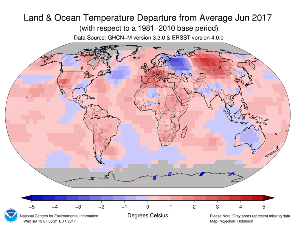
Global temperature profile of 2017 looks almost flipped from 2013. Even here you can see quite clearly that something was off.
1 likes
The above post is not official and should not be used as such. It is the opinion of the poster and may or may not be backed by sound meteorological data. It is not endorsed by any professional institution or storm2k.org. For official information, please refer to the NHC and NWS products.
-
TropicalAnalystwx13
- Category 5
- Posts: 2109
- Age: 28
- Joined: Tue Jul 19, 2011 8:20 pm
- Location: Wilmington, NC
- Contact:
Re: 2017 indicators: SST's / MSLP / SAL / Steering / Instability
People referencing 2013 are no different than people who reference 2005, just on the opposite extreme. The signs that 2013 would vastly under perform were well established by now (we just didn't take note until early September).
Last edited by TropicalAnalystwx13 on Thu Jul 27, 2017 8:01 pm, edited 1 time in total.
1 likes


Re: 2017 indicators: SST's / MSLP / SAL / Steering / Instability
Hammy wrote:2013 was a global problem with the thermohaline circulation which caused the global weather pattern to remain in spring. For evidence this year is not 2013, just look at how the EPAC has been--four hurricanes which struggled to make low to mid-range Cat 1; this year so far has had a Cat 4, 3, and 2 already--and we were getting major outbreaks of cold air (and significant rainfall) in the southeast--something that's been largely absent this year. The reason people were wrong in 2013 was that nobody realized what was going on and didn't know how to read the signs--this year those signs simply aren't there. And many active seasons (especially during suppressive MJO phases) were inactive from the middle of July through the middle third of August.
That said, if anybody has any data on the thermohaline circulation it would be a welcome addition to the discussion.
And a reminder on the models: the GFS is more conservative than the previous model. Don formed with almost no model support, and we may end up having only 3-5 days notice before the next storm develops.
A lot of that is hard to predict ahead of time and is easy to come up with signs or examples in hindsight. We don't have great skill in everyday weather beyond 7 days no less more than that. IF there is some reason the season under-performed it's not likely we'd predict it ahead of time besides the usual easy clues like shear or mid level dry air. That said, the good signs outnumber the bad signs thus far. There's a reason why thermohaline circulation data you won't find much on if at all, because it's not one that's easily forecast-able. A good place to start would be how slow 2013's arctic sea ice melt was, likely some effects of northern latitudes effecting salinity and overturning of currents as the thermohaline circulations starts in the polar regions.
0 likes
The above post and any post by Ntxw is NOT an official forecast and should not be used as such. It is just the opinion of the poster and may or may not be backed by sound meteorological data. It is NOT endorsed by any professional institution including Storm2k. For official information, please refer to NWS products.
Help support Storm2K!
Who is online
Users browsing this forum: dexterlabio, HurricaneRyan and 70 guests